All Activity
- Past hour
-
The 12z UK is a must check for shits and giggles for this region.

-
MAV is 30° at CON. That’s a little close for comfort for me. But I really don’t want to bring the plants in. Hopefully the waterlogged lawn keeps the temp up. The high was 62° and usually a good rad night is a 25° drop from that…so 37ish. I’ll be surprised if we go under 34°. 59.5/28 right now
-

Spring 2025 Medium/Long Range Discussion
Spartman replied to Chicago Storm's topic in Lakes/Ohio Valley
6-10 day: 8-14 day: Just in time for Memorial Day weekend :sarcasm: -
If nothing else - instability looks better than prior events so far this year. Still so far out - we'll see. (my famous two words)
- 485 replies
-
- 1
-

-
- severe
- thunderstorms
- (and 2 more)
-
A spectacular double-rainbow from last Sunday (May the Fourth Be With You Day!!!)

-
100 degrees up in the frozen tundra of northwest MN. Very early for that kind of heat.
-
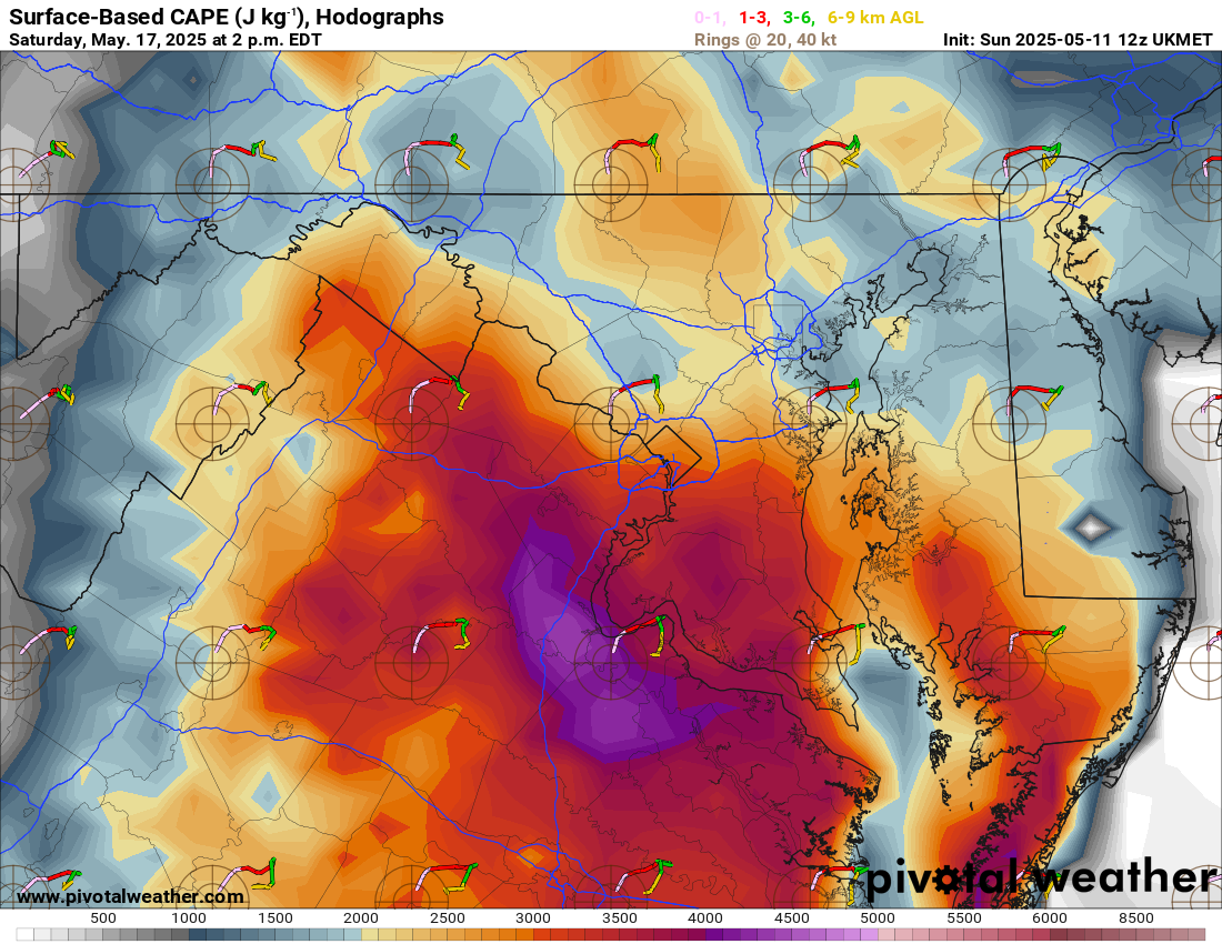
@Kmlwx @Eskimo Joe @high risk this sounds great for now lol (from the afternoon AFD from LWX) As we move toward the end of the week, a deep upper low and attendant strong surface low will slowly track eastward into the Upper Great Lakes. As this occurs, rich low-level moisture will be drawn north and east from the Gulf into the Ohio Valley and Mid- Atlantic. Simultaneously, a strong belt of mid-level flow (35-50 knots in the 700-500 hPa layer) will spread overtop that rich low- level moisture, advecting a remnant elevated mixed layer plume eastward as it does so. Rich low-level moisture, steeper than climatology mid-level lapse rates, and strong mid-level flow will result in an environment on Friday, and potentially even Saturday as well, characterized by both strong instability and strong deep layer shear. The EPS and GEPS ensemble means have 2000-3000 J/kg CAPE along with 35-50 knots of 0-6 km bulk shear. The GEFS show lesser instability and similar shear values, but have a well-know low bias when it comes to instability. This type of parameter space raises concerns for severe thunderstorms. While the parameter space being advertised at the moment by models is toward the higher end of what we typically see in this part of the country, we`re still at day 6 and 7, and there is plenty of time for things to change, especially when an upper level low is involved (which models notoriously struggle with in the long range). With an elevated mixed layer involved, there are also signs of stronger capping than we typically see, so that could complicate things as well. For now, the end of the week is a period to monitor for potential severe thunderstorms, with the expectation that the forecast can and will change this far out.
-
FFWs likely coming tomorrow SHORT TERM /MONDAY THROUGH TUESDAY NIGHT/... Monday will act as a day of transition ahead of a wet pattern setting up through around mid-week. The mentioned upper low swirling across the Deep South is part of a larger scale blocking regime (Rex Block). As a deep upper trough swings into the western U.S., this will help nudge the stalled downstream upper low. As this feature gains latitude in time, so will its immense moisture pool, strong jet forcing, and overall shift in sensible weather. Its slow poleward movement will carry some risk of flooding, particularly where upslope trajectories come into play (i.e., the eastern slopes of the Blue Ridge Mountains). Although the local area is in continued drought conditions, forecast rainfall amounts are high enough to cause some flooding concerns late Monday through at least Tuesday night. The latest forecast package calls for rain to arrive into the Potomac Highlands and central Shenandoah Valley by Monday morning. Amounts should initially be light, particularly in light of initial dry boundary layer conditions which may cause some evaporation to occur. However, eventual moistening of the column is expected which will gradually increase overall precipitation efficiency. The swath of showers is expected to track northeastward in time before reaching the I-95 metros by around the evening rush hour. Despite all of the increased cloud cover, high temperatures should still reach the low/mid 70s, with 60s more likely across the central Shenandoah Valley back into the Alleghenies. Conditions continue to deterioriate into the night with southeasterly moist advection further increasing. This moisture plume appears tied all the way down through the southern Gulf of America into the western Caribbean. Characterized by precipitable waters around 1.50 to 1.60 inches, this is easily 1.5 to 2 standard deviations above average for mid-May. Not surprisingly, forecast rainfall amounts are quite high, but are also variable due to uncertainies in the upper low track. By Tuesday morning, the main upper low is expected to lift across the Mid-South toward the southern Appalachians. The surface reflection of this system weakens as the upper low slowly begins to fill, but the quality of moisture remains intact. Tuesday will offer plenty of rainfall with 6-hour totals in the 0.25 to 0.50 inch range, locally higher toward the Blue Ridge. Given how spread out this event occurs over, much of this rain could prove to be beneficial in nature. However, this will less likely be the case along and east of the Blue Ridge where storm totals could be double the rest of the area. Current forecast storm totals are around 1.50 to 2.00 inches, but with 2.50 to 4.00 inches in the mentioned mountainous locations. While Flood Watches are not out yet, these will likely be considered during subsequent shifts.
-
-
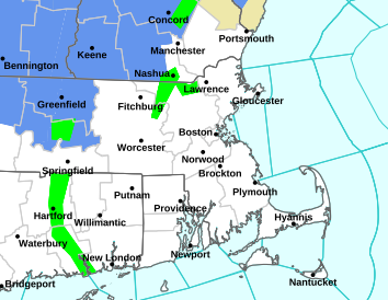
Another boring non event. Oh joy lol
- Today
-
I was a little surprised to see those clouds, is that storm ahead of schedule? Forecasts didn't have any clouds coming in here before tomorrow afternoon!
-
Got to 80, some high scattered wispy clouds from the system down in the southeast otherwise pristine today!
-

E PA/NJ/DE Spring 2025 Obs/Discussion
RedSky replied to PhiEaglesfan712's topic in Philadelphia Region
-
What Wiz said. You also have it in nonfilter mode so it’s showing the very low reflectivities. Radarscope has a color pallette to filter that out. You probably already know that because I think that’s the default.
-
One of the nicest Mother’s Day ever. Pristine weather. High temp of 78.4 on my station.
-
-
Beach day besides the 50 degree water temp lol
-

Spring 2025 Medium/Long Range Discussion
TheClimateChanger replied to Chicago Storm's topic in Lakes/Ohio Valley
Impressive heat in the upper Midwest. Up to 99F as of 1 pm at Grand Forks, North Dakota. Should have no problem clearing 100+, which would be the second earliest on record. The earliest 100+ reading occurred on April 21, 1980. There have only been 3 days in the month of May at or above 100F in recorded history at that location: 101F on 5/21/1964; 105 on 5/30/1934; and 100 on 5/30/1939. The monthly record high of 105F is probably safe, but I could see the high ending up between 102F and 104F with 2-3 hours of heating possible, so it could make a run for it. At Grand Forks, there have been a total of 62 days at or above 100F recorded since 1893. If it gets above 102F, that would be pretty rarified air for any time of the year. There have only been 20 days above 102F, of which 8 occurred during the summer of 1936, which was particularly harsh in that region. -
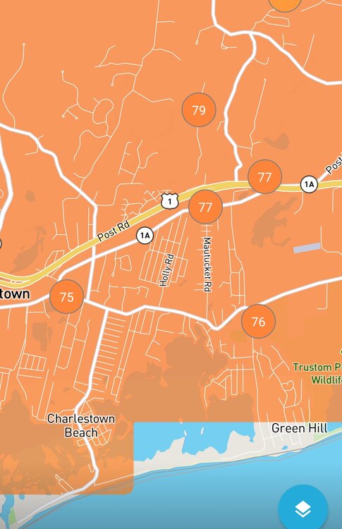
For South County RI this time of year I would consider this good beach weather. My truck hit 80 a few times along route 1. I think it's the sand in this area but right now it is one of the warmest according to the wunderground stations. It's even like 75-77 out on Pt Judith.
-
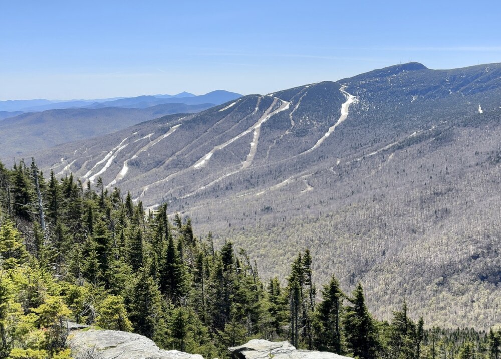
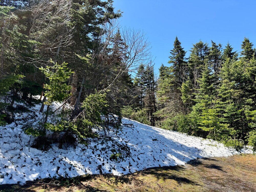
Nice day for sure. Still some drifts around and shaded snowpack.
-
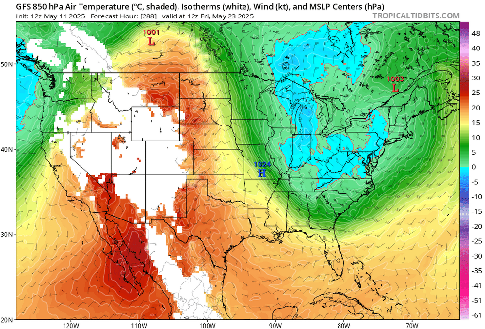
Though too early for any real certainty, somewhere between a weak Niña to weak Niño are the table at this point, with a La Nada of some sort favored imho. SOI has been dropping lately, fwiw, per attached. When you look at everything, there really are mixed signals on how winter goes in the east imho. But, admittedly, that ain't saying much other than equivoval, meteorological drivel. But I tried my best to sound good lol.
.thumb.png.96fd9ab6395fcdb12fb4272fcdfc74d2.png)
-
Not sure I’d call it a beach day but it’s nice out.
-
79 at 2.
-
E PA/NJ/DE Spring 2025 Obs/Discussion
RedSky replied to PhiEaglesfan712's topic in Philadelphia Region
GFS is hideous with 6 straight days of clouds and showers after tomorrow. Then a deep trough digs in... Hello May 2005 -
I believe with clear air mode the radar is more likely to pick up stuff like dust or even pollen


.png.1b0c00afd803ace9d30121601d20dd26.png)


