All Activity
- Past hour
-
Topped out at 92 yesterday.
-
In the next few years I will replace my 2018 CX-5. But it probably won’t be for the new one. What they did to that poor car…
-

Central PA Summer 2026 Discussion/Obs Thread
mahantango#1 replied to Voyager's topic in Upstate New York/Pennsylvania
-
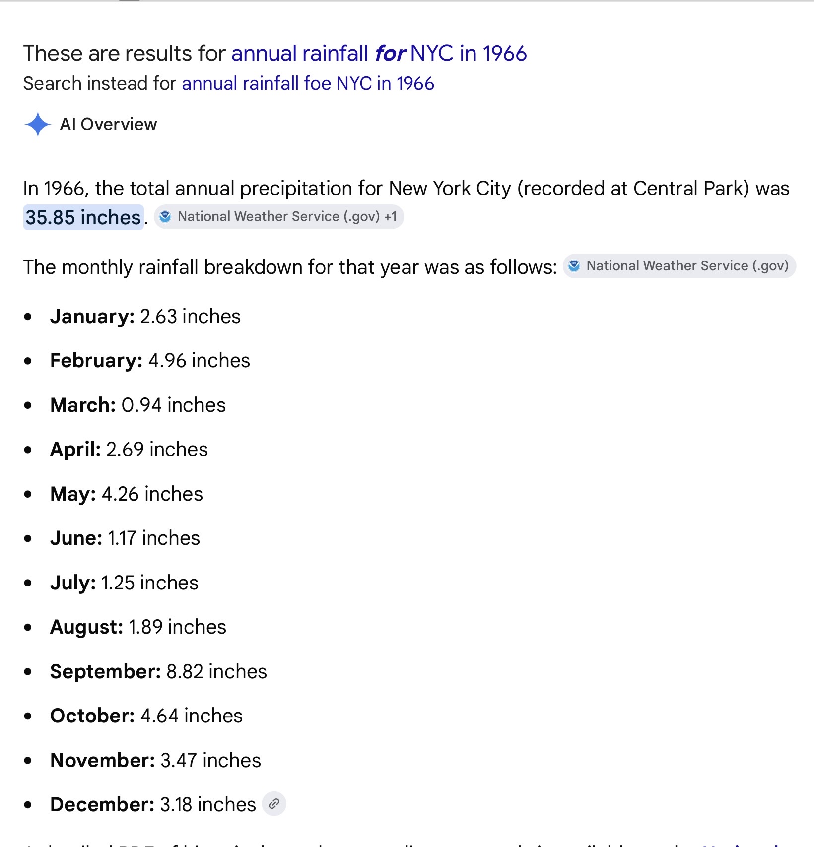
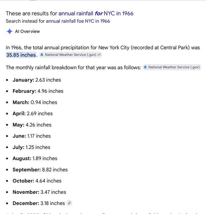
Good morning MANDA, FPizz. I was 19 that year. I remember water restrictions and people having wells dug in their back yards. I simple searched 1966 rainfall. For NYC, the summer was extremely dry. There may have been a tropical system involved in the September total, I just don’t recall. You need no correction, MANDA, about that summer. Stay well and hydrated. As always ….
-
Sometimes, despite the apparent talent, it just doesn't work collectively. Not aways easy to pin down, and in most cases there are multiple reasons. Look at the Mets the past 2 seasons. Absolute disaster. I think its time to make changes. Make some deals at the deadline but more for the future, not necessarily to try to win now. Trade Alonso. Get a couple good younger players, and jettison players like Mayo and Cowser. Busts.
-
The last month that my station had 5+ inches of rain was Aug 2024. The prior 14 months saw 7 of them exceeding the 5" mark. Really impressed with the suddeness of and now the longevity of this drought.
-
Home brew next week?
-
I take their sloppy leftovers of rain/light rain from what’s left of the complex
-
Storms Wednesday-friday look isolated at best. Maybe scattered Saturday, with far NW favored. Potentially widespread Sunday and Monday.
-

Central PA Summer 2026 Discussion/Obs Thread
Mount Joy Snowman replied to Voyager's topic in Upstate New York/Pennsylvania
Low of 66. Bring on the heat. -
NYC and other locations continuing the drought pattern which emerged back in September 2024. NYC hasn’t had a month with above average precipitation since May 2025. This will enhance the record heat potential around the area going into July. June 2026 MONTH TO DATE 3.39 4.41 -1.02 May 2026 NATIONAL WEATHER SERVICE NEW YORK, NY 635 PM EDT MON JUN 01 2026 ................................... ...THE CENTRAL PARK NY CLIMATE SUMMARY FOR THE MONTH OF MAY 2026... CLIMATE NORMAL PERIOD 1991 TO 2020 CLIMATE RECORD PERIOD 1869 TO 2026 WEATHER OBSERVED NORMAL DEPART LAST YEAR`S VALUE DATE(S) VALUE FROM VALUE DATE(S) NORMAL ................................................................ TEMPERATURE (F) RECORD HIGH 99 05/19/1962 LOW 32 05/06/1891 HIGHEST 93 05/19 MM MM 85 05/03 LOWEST 45 05/03 MM MM 47 05/23 AVG. MAXIMUM 71.5 71.4 0.1 69.5 AVG. MINIMUM 54.9 55.0 -0.1 55.2 MEAN 63.2 63.2 0.0 62.3 DAYS MAX >= 90 2 1.0 1.0 0 DAYS MAX <= 32 0 0.0 0.0 0 DAYS MIN <= 32 0 0.0 0.0 0 DAYS MIN <= 0 0 0.0 0.0 0 PRECIPITATION (INCHES) RECORD MAXIMUM 10.24 1989 MINIMUM 0.30 1903 TOTALS 3.05 3.96 -0.91 6.58
-
 LFG Wed Thu
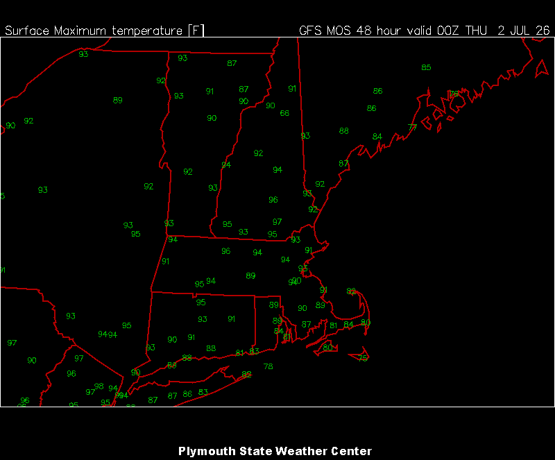

-
Exactly
-
Congrats NY and VT.
- Today
-
Wow
-
Let’s just hope these convective complexes make it to where 99% of this subforum actually live.
-
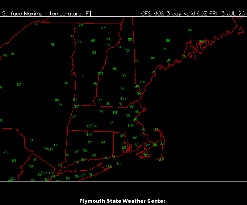
It's not scaling back. 105+ readings on the table Thurs-Fri
-
I was hoping to hold up a large metal pole as well. Is that a good idea?
-
It's been a pretty pleasant last two weeks with only one day touching 90° here... That's about to change me thinks, 70° low this am.
-

Central PA Summer 2026 Discussion/Obs Thread
anotherman replied to Voyager's topic in Upstate New York/Pennsylvania
This is what you’ve been waiting for! How exciting! -

Central PA Summer 2026 Discussion/Obs Thread
Voyager replied to Voyager's topic in Upstate New York/Pennsylvania
Even here, Thursday and Friday are 99 and 98 respectively. On top of that, I can't ever remember Schuylkill County being included in an Extreme Heat Warning, let alone for multiple days. Back in 2011, we hit 103, unofficially, on my weather station. It'll be interesting to see what I register with this one. -

Central PA Summer 2026 Discussion/Obs Thread
TheDreamTraveler replied to Voyager's topic in Upstate New York/Pennsylvania
God might be 99, 102, 102 and 98 here during this heat wave. The pool temp is already 80 degrees if it gets any warmer than that it's not even going to feel refreshing to be in lol -
Seems like the Euro loves throwing out outrageous temps just like it does during the winter only to scale back.
-
Hear=t advisories posted for virtually the entire LWX area. WWA Summary for Heat Advisory Issued by LWX
-

2026-2027 Super El Nino
Stormchaserchuck1 replied to Stormchaserchuck1's topic in Weather Forecasting and Discussion
I think the PDO may start to trend positive decadally when the Summer Arctic ice catches up with its previous trend or starts "evening out all this warm season cold anomaly". What do you think @40/70 Benchmark?