All Activity
- Past hour
-
Well if get anything later tonight it’s that complex developing over Michigan.
-

2026 Mid-Atlantic Severe Storm General Discussion
high risk replied to Kmlwx's topic in Mid Atlantic
Sorry. Bad wording on my part. The southeast PA reference was regarding where the complex heads as it moves out of western PA.- 2,404 replies
-
- 1
-

-
- severe
- thunderstorms
- (and 7 more)
-

E PA/NJ/DE Autumn 2026 Obs/Discussion
Newman replied to PhiEaglesfan712's topic in Philadelphia Region
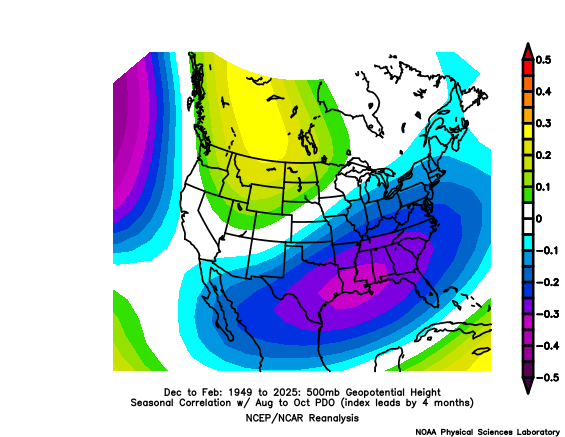
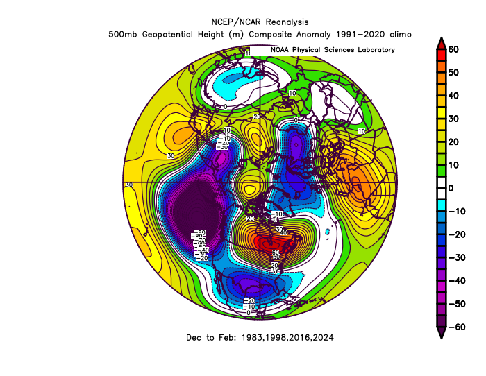
I've honestly not taken much of a long look into the upcoming 2026-27 winter prospects but did take a quick peek at it just now. First of all, as of right now, it seems like the tropical Pacific and North Pacific *appear* to be out of sync and not quite coupled. Obviously we have a super Nino ongoing and expected to peak this fall. We're coming off a very negative SOI in July, I think the lowest since the 1980s. When taking a seasonal correlation of DJF 500mb heights to ASO SOI, you get a pretty canonical look. Positive correlations between SOI and 500mb heights in the SE US, meaning the negative SOI usually correlates to negative heights across the southern US, and then positive heights across the northern tier. However, we may have a competing signal given there is (currently) a lag in response of the PDO to the developing Nino. August PDO is still negative, which is counterintuitive to what you'd expect during a strong Nino. In fact, I simply can't find any year at all that followed a typical ENSO progression to this year (strong to super Nino developing, peaking in the fall, then waning and eventually switching to Nina the following year) and also had a negative PDO. We still have time before winter for the North Pacific to respond, but for posterity, here is the correlation map between ASO PDO and DJF 500mb heights. It's actually a very impressive negative correlation in the SE US, one that is more statistically significant than the SOI signal. The negative PDO usually correlates to positive heights in the SE US (big ridge in the eastern US), and that is opposite to the map above. So that begs the question here... IF the PDO continues to lag into the winter and we have a Nina like North Pacific but Nino tropical Pacific, how will the winter turn out? I'm under the opinion that we will see a North Pacific "coupling" this fall with the tropics, but I'm cautious about it until I see it. We've seen this persistent negative PDO for so long, aided by the marine heat wave off Japan, so idk. Just for further posterity, here is the 500mb height anomalies of 4 super Nino winters we've seen recently, which looks like a pretty canonical Nino pattern in the mean. But with Nina effects lingering, will we see a similar pattern this year? Long winded thoughts, but my idea this winter is a pretty torchy start into December and early January. We might see some brief negative NAO spikes by late Jan and Feb which is when we'll need to time an active STJ storm with an arctic front that's pressed off the coast. Even if not, probably some chances for cold spells. I'm also not a long range forecaster so take everything with a grain of salt LOL @GaWx What are you thinking/seeing for this winter in the East?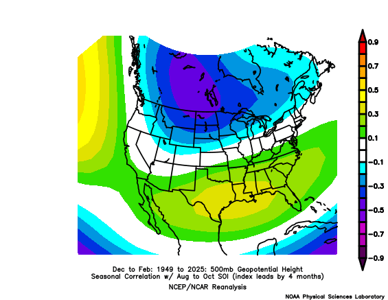
-
SVR warned for hail to ping pong ball size and winds to 60mph
-
0.01" here, woo hoo
-

2026-2027 Record-breaking El Nino
PhiEaglesfan712 replied to Stormchaserchuck1's topic in Weather Forecasting and Discussion
Do we now have a relative and a traditional PDO now (like we do with the ONI)? This one shows July as -2.14 and August as -1.84: https://www.ncei.noaa.gov/pub/data/cmb/ersst/v5/index/ersst.v5.pdo.dat -

Septorcher 2026 Discussion - Endless Summer
HoarfrostHubb replied to Damage In Tolland's topic in New England
A bit of a mixed bag. Not terrible for sure. We take. -
Yeah a pretty nice line between 1 and 2 am
-

Septorcher 2026 Discussion - Endless Summer
weatherwiz replied to Damage In Tolland's topic in New England
Some concerning guidance and trends for at least portions of the Hawaiian Islands regarding Lowell -
Currently 100 with a dew point of 72 giving me a heat index of 110… Brutal doesn’t even describe this well enough
-
I see HRRR hits us during the overnight hours. Who knows.
-

Central PA Summer 2026 Discussion/Obs Thread
Jns2183 replied to Voyager's topic in Upstate New York/Pennsylvania
best ring of fire action I've seen in years and it's quite delayed from normal Sent from my SM-S731U using Tapatalk -
84 here and feels hot with the dewpoint at 70.
-
https://www.spc.noaa.gov/products/outlook/day3otlk.html https://www.spc.noaa.gov/products/outlook/day2otlk.html SPC has marginal risk out for parts of East Tennessee for day two just for 5% damaging wind and also a marginal and slight risk out for day 3 5-15% probabilistic probabilities .
-
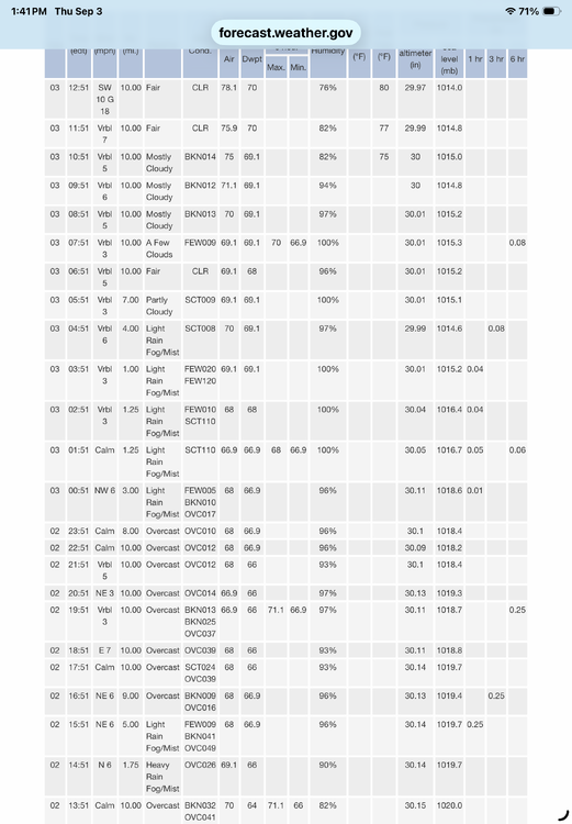
.39 for Central Park. ….. and I thought it was only South Brooklyn Italian. …. As always ……
-

Septorcher 2026 Discussion - Endless Summer
Damage In Tolland replied to Damage In Tolland's topic in New England
Will be plenty of time for that in January -
yikes....guy had init: august 26
-

Central PA Summer 2026 Discussion/Obs Thread
Itstrainingtime replied to Voyager's topic in Upstate New York/Pennsylvania
Forecast HI this afternoon: 102. Actual HI at 1:40pm: 87 -
we in midseason form or what?
-
That says August. The August forecast isn’t new. The Sept 1st forecast is the new one we’re waiting for. The monthly Euro forecasts are normally released on the 5th of the month.
-
Radarscope claims rotation with the storm out in W VA (near Broadway)
-
Getting the sun to destabilize is something we were missing the last few days. Could get interesting later .
-

Septorcher 2026 Discussion - Endless Summer
40/70 Benchmark replied to Damage In Tolland's topic in New England
Lets get cloudy, cool weekend afternoons with the sound of football filling the airwaves, and the scent of smoke in the nasal passage with rake in hand. -
Septorcher 2026 Discussion - Endless Summer
40/70 Benchmark replied to Damage In Tolland's topic in New England
If I had my way, it would be drizzle and 43 all weekend, so it's fine by me. -
About .4 from the stuff that woke me up overnight. Im still mowing every 5 days-ish and im ready to pour concrete over the whole damn thing and go bronx italian.