All Activity
- Past hour
-
Niña's don't always act like niñas, like last year.
-
 There are two typhoons, Neoguri and Ragasa. Neoguri as at 95 kt, and Ragasa is at 100 kt and heading toward the strait of Taiwan, eventually towards Hong Kong as a large storm. It is expected to reach peak intensity of 135 kt (category 5) at the strait of Taiwan, so I'd expect a large amount of rain is heading for Hong Kong. The WPAC has been very below normal ACE.
 -
Saw my first lantern fly in Deep Creek unfortunately. Stomped the fcker.
-

September 2025 OBS-Discussion centered NYC subforum
SACRUS replied to wdrag's topic in New York City Metro
Records: Highs: EWR: 92 (1983) NYC: 93 (1983) LGA: 90 (1983) JFK: 85 (1997) Lows: EWR: 44 (1979) NYC: 44 (1993) LGA: 46 (1979) JFK: 41 (1979) Historical: 1845 - A tornado traveled 275 miles across Lake Ontario, New York and Lake Champlain. (Sandra and TI Richard Sanders - 1987) 1909 - A large and deadly Category 3 hurricane made landfall near Grand Isle, Louisiana during the late evening hours. The states of Louisiana and Mississippi showed catastrophic damage resulting in 371 deaths and $265 million in damage 1909: A large and deadly Category 3 hurricane made landfall near Grand Isle, Louisiana during the late evening hours. The states of Louisiana and Mississippi showed catastrophic damage resulting in 371 deaths and $265 million in damage (2010 USD). 1926 - A hurricane which hit Miami, FL, on the 18th, pounded Pensacola with wind gusts to 152 mph. Winds raged in excess of 100 mph for four hours, and above 75 mph for 20 hours. (The Weather Channel) 1953: A strong upper level ridge was responsible for record highs across Texas & parts of Arizona. Midland set their all-time September record high with 107°. Other daily record highs included: Phoenix, AZ: 105°-Tied, Wichita Falls, TX: 103°, Dallas, TX: 102°, Dallas (DFW), TX: 102°, San Angelo, TX: 102°, Abilene, TX: 101°-Tied and Waco, TX: 100°-Tied. (Ref. Wilson Wx. History) 1961: Hurricane Esther, a Category 4 storm off of Cape Hatteras, NC began to slow down as it moved north-northeast well off the Jersey shore. The storm continued to weaken as it did a 5 day loop south of Cape Cod, MA then moved across Cape Cod and into Maine on the 26th. (Ref. Wilson Wx. History) 1967 - Hurricane Beulah moved into South Texas, and torrential rains from the hurricane turned the rich agricultural areas of South Texas into a large lake. Hurricane Beulah also spawned a record 115 tornadoes. (David Ludlum) 1969: On this date through the 23rd, heavy rain over several days brought extensive flooding to the Apalachicola River at Quincy, Havana, and Blountstown; and much of Franklin, Gadsden, Leon, Calhoun and Quincy Counties in the Florida panhandle. Havana 23.42", Quincy reported 18.41" of rain and Blountstown 10.41". Several funnel clouds and waterspouts were reported from northwest Florida to the Keys on the 22nd and 23rd. (Ref. Wilson Wx. History) 1972: Downpour in Duluth, MN with 5.50 inches of rain falling in ten hours. (Ref. AccWeather Weather History) 1980: Much of northwest Iowa received violent severe weather. In O'Brien, Clay, Monona, Crawford and Buena Vista counties, high winds and hail pounded crops and buildings. Winds of 70 to 75 mph blew trees down on power lines, houses and cars. Hail up to the size of baseballs severely damaged crops with over $10 million dollars in losses. In Ricketts, every north and west window was broken from the hail. The strong winds destroyed many farm structures in these counties. In addition, a strong tornado touched down in Spencer completely leveling several metal warehouse buildings in an industrial park. (Ref. Wilson Wx. History) 1983 - The temperature at West Yellowstone MT plunged to six degrees below zero, while the temperature at San Francisco CA soared to 94 degrees. (The Weather Channel) 1986: A slow moving quasi-stationary front produced flash flooding occurred in parts of central Illinois, primarily from near Peoria and Lincoln eastward to Bloomington, as rainfall amounts ranged from 3 to 7 inches. Bloomington reported 7.12 inches in 4 hours during the overnight, causing significant flooding. (Ref. Wilson Wx. History) 1987 - Afternoon and evening thunderstorms produced severe weather in Oklahoma and west Texas. In Oklahoma, a thunderstorm at Seiling produced three inches of rain in one hour, golf ball size hail, and wind gusts to 60 mph which collapsed a tent at the state fair injuring nine persons. (The National Weather Summary) (Storm Data) 1988 - Showers and thunderstorms produced locally heavy rains in central Wyoming, and snow in some of the higher elevations. Casper WY reported 1.75 inches of rain in 24 hours, and a thunderstorm north of the Wild Horse Reservoir produced 1.90 inches of rain in just forty minutes. 1989 - Hugo jilted Iris. Hurricane Hugo churned toward the South Atlantic Coast, gradually regaining strength along the way. Tropical Storm Iris got too close to Hugo, and began to weaken. A cold front brought strong and gusty winds to the Great Basin and the Southern Plateau Region, with wind gusts to 44 mph reported at Kingman AZ. (The National Weather Summary) 1995 A strong late summer storm brought the season’s first snow to parts of the Rockies. Denver, CO reported 4 to 8 inches of heavy wet snow that damaged millions of trees and downed power lines into Boulder leaving 100,000 people without electricity. It took a week to fully restore power to all areas. Total insured losses in the Denver area was $6.5 million dollars. Record cold followed the storm as the low at Denver dropped to 27° the next morning followed by an afternoon high of 36°. Further north, 2 to 8 inches of snow was reported at Cheyenne, WY. Record cold accompanied the storm. Record lows included: Glasgow, MT: 20°, Great Falls, MT: 24°, Havre, MT: 24°, Grand Island, NE: 32° and Pueblo, CO: 32°. Viroqua, WI set their all-time record low for September with 20°. (Ref. Wilson Wx. History) 1998: Hurricane Georges reached its top strength of 155 mph sustained winds when it was 420 miles east of Guadeloupe early this morning; top winds were 115 miles an hour at landfall on Puerto Rico on the PM of the 21st. 28,005 homes were destroyed but only 12 deaths were reported in Puerto Rico due to preparedness. (Weather Guide Calendar with Phenomenal Weather Events 2007 Accord Publishing, USA) Georges' Track - Weather Underground (Ref. AccWeather Weather History) 2000: An F4 tornado devastated some of the same portions of Xenia, OH that were damaged in the April 3, 1974 twister. No tornado warning was issued when the storm struck, raising the ire of local residents. Record heat prevailed across parts of the southwest courtesy of a large upper level heat ridge. Record highs included: Death Valley, CA: 116°, Palm Springs, CA: 115°, Borrego Springs, CA: 110°, Victorville, CA: 104°, Stockton, CA: 101 °F. (Ref. Wilson Wx. History) 2002: A F2 tornado touched down WNW of Washington, IN. It destroyed/damaged several homes. The tornado lifted/tossed a vehicle 1/8th mile; the conservation officer inside survived. (Ref. Weather Guide Calendar with Phenomenal Weather Events 2011 Accord Pub. 2010, USA) 2005 - Hurricane Rita tracked through the Florida Straits and just south of the Florida Keys. Winds were sustained at tropical storm force at Key West, where peak winds gusted to 76 mph. -

September 2025 OBS-Discussion centered NYC subforum
Stormlover74 replied to wdrag's topic in New York City Metro
And hopefully some rain Tuesday night -
Ensembles are well into Octorcher
-
Hey
-

September 2025 OBS-Discussion centered NYC subforum
winterwx21 replied to wdrag's topic in New York City Metro
Mid 70s with the dewpoint in the high 40s and not a cloud in the sky ..... as perfect as it gets today. We'll be going back to summer on Tuesday though with highs in the mid 80s and dewpoints in the mid 60s. -

September 2025 OBS-Discussion centered NYC subforum
donsutherland1 replied to wdrag's topic in New York City Metro
That's now a fairly common outcome. The combination of site changes in Central Park (overgrowth of trees), increasing urbanization in the vicinity of the LGA/JFK sites (growing heat island, especially at LGA), and more frequent abnormally warm SSTAs off JFK have contributed. The latter two factors are more prominent during the winter months e.g., last winter was a prominent example where JFK had a warm seasonal temperature anomaly while Central Park had a cold one relative to the 1991-2020 baseline. Summer 2025 provides a strong example of the impact of Central Park's trees where Central Park could not reach 100° during the region's hottest June air mass on record.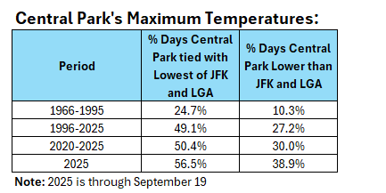
-
Regarding TCs that hit Conus, the latest TCG date on record E of 50W is Sep 25 (1893).
- Today
-
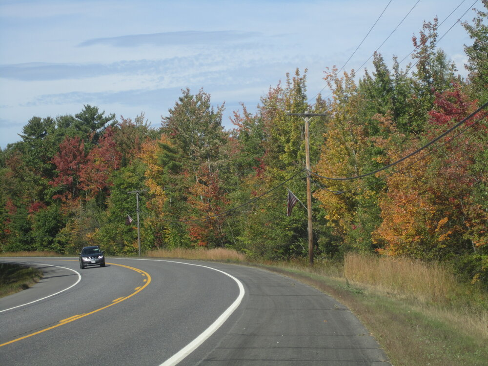
Color has popped here.
-
I’m sort of hoping it does. Less pressure on ground water supplies, though I’m not sure if that would actually help all that much.
-
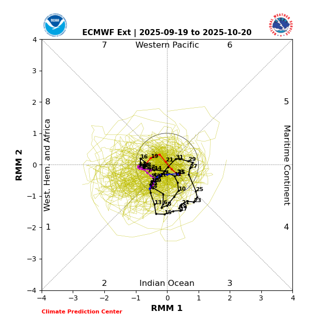
MJO forecasted to stay in the null phase...if that verifies a strong finish to the hurricane season may not materialize.
-
Overall, it's looking like we'll at least have a normal winter in general. Something we really haven't seen in several years. At least in Southern New England.
-

September 2025 OBS-Discussion centered NYC subforum
LibertyBell replied to wdrag's topic in New York City Metro
deep blue skies are the best!! tomorrow won't be as good with high clouds coming in early -
September 2025 OBS-Discussion centered NYC subforum
LibertyBell replied to wdrag's topic in New York City Metro
High clouds coming in tomorrow morning so it won't be as nice as it is today. I noticed that SST have already started dropping and are in the mid to upper 60s now, even along the Jersey shore? -
September 2025 OBS-Discussion centered NYC subforum
LibertyBell replied to wdrag's topic in New York City Metro
The funny thing is NYC and LGA bringing up the rear in temperatures. NYC seems to have the lowest temperatures no matter the wind direction lol. -
"Early Corner" in New Sharon, along US Rt 2 about 1/2 mile west from the Sandy River bridge. The soil there is somewhat poorly drained, almost a forested wetland, which causes the early change. It's about a week earlier than average, probably due to drought, though the 5 mornings in the 30s last week might've helped. This morning's 30 and tomorrow's frost/freeze will push the changes along, though there's an abnormal amount of leaf drop already, in that area and all over, especially ash, birch and red maple.
-

2025-2026 ENSO
PhiEaglesfan712 replied to 40/70 Benchmark's topic in Weather Forecasting and Discussion
Three of those years rank among the 11 hyperactive (180+ ACE) seasons, with 2 of the Top 3 overall: 1 2005 247.65 3 1893 231.0738 11 2020 180.3725 -
Homegrown storms will be the thing moving forward. The Atlantic basin should be closing shop soon.
-
I think this validates what I said-no longer east based but more basin wide and weak. Probably will be less of a factor in terms of predictability of the season this year.
-
Please stay warm for a while.
-

September 2025 OBS-Discussion centered NYC subforum
steve392 replied to wdrag's topic in New York City Metro
Gorgeous out! 70 in Dumont, nj. Not a cloud in sight. -

2025-2026 ENSO
Daniel Boone replied to 40/70 Benchmark's topic in Weather Forecasting and Discussion
Enso is always their main source for their Seasonals, as we all know. -
I’m not sure there’s going to be much color.


