All Activity
- Past hour
-
-
Wow, actually looks like 2012 at times. People should be happy as we'll finally be moving on to spring. Y'all had a great winter, no one should be complaining about this.
-
So for the dedicated snow weenies here, what is your take on when ASOS reports UP? I always thought it was IP, but can it be a mix of R/S/ or R/IP or S/R/IP? Never ZR?
-
Wow it’s nice out, might have to take a break and wash the car
-
Ayer MA SNOINCR 8! Bright-banding was not melting snowflakes aloft, it was giant dendrites making to the surface! This was a watershed event in a way b/c it was then recognized how important the DGZ was (not all snowflakes created equal!) Seriously, DGZ and flake type was not a thing prior, and least in mainstream forecasting. Pretty MEH sfc low as well for this event. Not much wind either.
-
IF this occurs, we’d be looking at the realistic possibility for the 2nd warmest March on record in places like Atlanta. Currently, their warmest on record is the 64.5F of 2012. That appears out of reach. However, their 2nd warmest is the 61.8 of 1945. As it is now, a record warmest first 1/2 of March near 64.5 is looking likely there assuming I haven’t missed any warmer ones. But then it’s looking to cool down significantly to ~50 for 3/16-22. That would bring the MTD down to ~60 as of March 22. Then March 23-31 would need to average 66.2 to get the full March average to 61.8. That’s ~8 AN for 3/23-31. I suppose there’d be a chance for it to be that warm although that’s 2-3 weeks away, too far to be able to predict.
-
Looks like it The warmth will finally be winning out. First time all winter. Not shocking since its near spring.
-
-

Occasional Thoughts on Climate Change
TheClimateChanger replied to donsutherland1's topic in Climate Change
-
Occasional Thoughts on Climate Change
TheClimateChanger replied to donsutherland1's topic in Climate Change
-
-
Snow or no snow, the cold is going to wipe out all these early blooms
-
Cant wait for lower 20s late next week killing everything
-

2026 Mid-Atlantic Severe Storm General Discussion
high risk replied to Kmlwx's topic in Mid Atlantic
As I noted earlier, I was down on the chances, because I'm not sure what would trigger storms during peak heating. The HiResW FV3, RRFS, and ECMWF do all suggest cells in our area, however, Wednesday afternoon in an overall somewhat favorable environment, so I can't ignore that. -
Beautiful blue skies here and nice and warm outside. Just brought something out to my client's car and it's gorgeous
-
You had your epicosity…be appreciative.
-
Yup..it’s beaut Clark. Feels like mid May. 70 is doable here too if we keep the breeze at bay.
-
Clouds can F off
-
There was a brief period of UP at the ASOS that may have been sleet, but we’ll never know.
-
Not going to happen .
-

-
F00king beautiful outside. 63 and full sunshine. Thank god it's Spring.
-
Ya hate to see it
-
Maxed at 60.8° about 10 min ago - now down to 57.2°
-
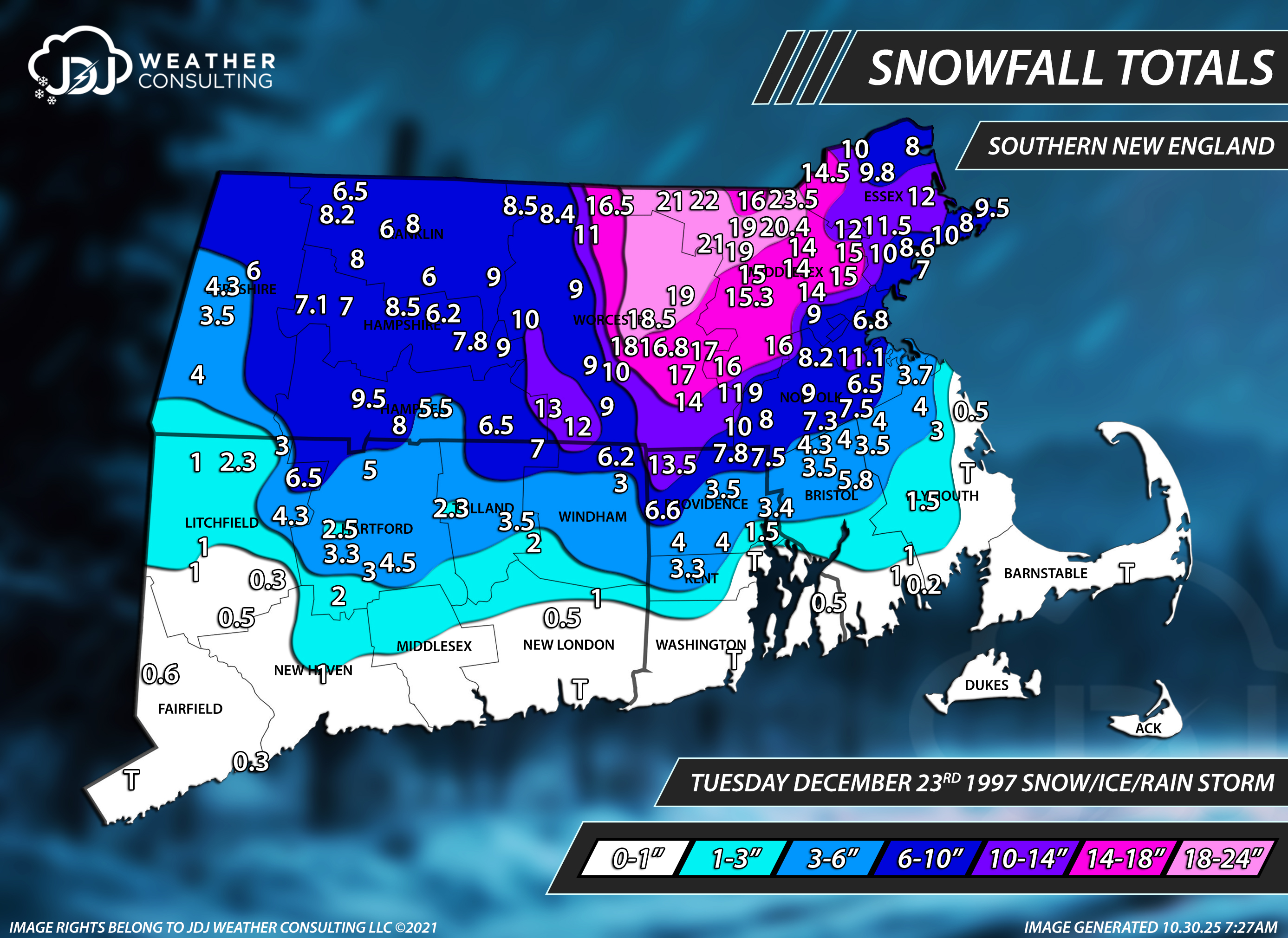
Most anomalous in terms of weirdness set up I have ever seen for a biggie snowstorm for SNE. Sfc low 600 mi SE of ACK when the big S+ kicked in late night on the 7th and turned the AM commute in a disaster b/c schools were not closed and the area was not prepared. I think the fcst the night before was a general 3-6" in ern MA. IIRC, the ECMWF had the most fcst for the event at 4-8", but even that was 3x too low! Biggest modern day bust for so much snow for a storm in the region. Another one that stands out was 12/23/1997. Fcst was 4-8" at best and we ended up w/ 12-24" for the event. BOS Herald cover the next day, "THEY BLEW IT!" and showed mug shots of all local OCMs! I still have the paper. Also, another big bust 12/5/2005. The CoastalWx special, he recalls that vividly in GHG. Woke up to this wind roar all of sudden from the NW and then when to S+. Small nor'easter very tight but wicked! One of the few times a nor'easter in New England product 100+ mph gusts (I can count on one had the number of times that has happen in the last 5 years). Usually, only hurricanes here give gusts that high! SNOINCR 9 reported in Andover MA area from a reliable source.