All Activity
- Past hour
-

E PA/NJ/DE Summer 2025 Obs/Discussion
MGorse replied to Hurricane Agnes's topic in Philadelphia Region
It has been that way for many years. -
Modest (at best) shear but a lot of cape and some downdraft cape. I guess it’s worth a SLGT, but right now, it’s a low- end SLGT.
-
But not in Atlanta, where they had a ~4.5” (major) snowstorm in early Jan, the biggest since the 3/1993 blizzard.
-
.thumb.png.4150b06c63a21f61052e47a612bf1818.png)
July 2025 Obs/Disco ... possible historic month for heat
HIPPYVALLEY replied to Typhoon Tip's topic in New England
I’ve been hanging at the town swimming area for the past hour and the breeze with mostly cloudy conditions is delightful. 84°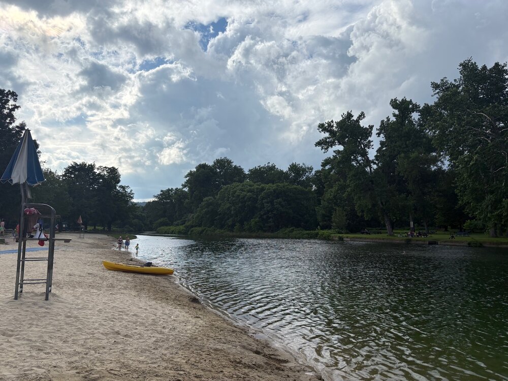
-

2025-2026 ENSO
Stormchaserchuck1 replied to 40/70 Benchmark's topic in Weather Forecasting and Discussion
^Man what a horrible SSTA map, lol Best thing is northern Indian Ocean isn't that warm. -
i see them right here in the local park. they are in all counties in nj now; you can spot them in raritan near the landfills too.
-
 Looks like another temperature Ghost Station with the Coatesville 1E precipitation only station....generating high and low daily temps without the observer doing so!
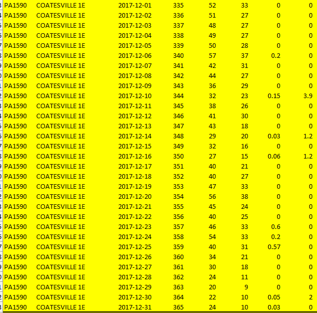
-
July 2025 Obs/Disco ... possible historic month for heat
HIPPYVALLEY replied to Typhoon Tip's topic in New England
Crazy fast! -
-
Hmmm I guess that's why there's all those mostly flat, easy to build on FLOODPLAINS along those bigger rivers. I guess that got away from them.
-

July 2025 Discussion-OBS - seasonable summer variability
Brian5671 replied to wdrag's topic in New York City Metro
True-any storm will be slow moving... -

July 2025 Discussion-OBS - seasonable summer variability
SnoSki14 replied to wdrag's topic in New York City Metro
It's a steambath out there. The right trigger and we could easily see massive flooding -
It’s stifling out.
-
The air conditioning is broken in my car and I got heat exhaustion on my way home from work.
-

July 2025 Discussion-OBS - seasonable summer variability
gravitylover replied to wdrag's topic in New York City Metro
I got over 2" that one day last week, I wasn't here for it, but other than that I've gotten it a few hundredths at a time. Today is at .1 (so far). -

Spring 2025 Med/Long Range Discussion
KakashiHatake2000 replied to John1122's topic in Tennessee Valley
yes john we are apparently supposed to get a lot of rain chances this week in this unsettled pattern with percentages really increasing by a lot by mid week and starting today and tomorrow according to reading my afds from meg ohx mrx and hun -

July 2025 Discussion-OBS - seasonable summer variability
Santa Claus replied to wdrag's topic in New York City Metro
i don’t think this is physiologically true but 80/78 feels worse to me than 102/80. my body is a nucleation point, i am becoming a giant drop of water. i am setting my apple watch workout to Outdoor Swim -

July 2025 Obs/Disco ... possible historic month for heat
Snowedin replied to Typhoon Tip's topic in New England
This is heaven..embracing every moment of the atmospheric sauna while the mosquitoes latch on to my ultra manly scent! Ya love to see it.. -
I'll warn @Rjay
-

July 2025 Discussion-OBS - seasonable summer variability
steve392 replied to wdrag's topic in New York City Metro
Sussex and NW Passaic counties for the win again. Just can't catch a break for rain now in se Bergen County. -

E PA/NJ/DE Summer 2025 Obs/Discussion
RedSky replied to Hurricane Agnes's topic in Philadelphia Region
The damage is being limited to southern Bucks, Montco and Philly -

July 2025 Discussion-OBS - seasonable summer variability
donsutherland1 replied to wdrag's topic in New York City Metro
Tomorrow will be very warm with highs reaching the upper 80s to perhaps 90° in New York City and the lower and middle 90s in Newark. Wednesday through Friday will be turn cooler with increased clouds. Highs will mainly reach the lower 80s on Wednesday and upper 70s to near 80° through Friday. Each day could feature the risk of some heavy thunderstorms. The rainfall amount could be enhanced somewhat by some of the moisture from Chantals remnants. No widespread excessive heat appears likely through mid-July. The ENSO Region 1+2 anomaly was +0.4°C and the Region 3.4 anomaly was 0.0°C for the week centered around July 2. For the past six weeks, the ENSO Region 1+2 anomaly has averaged +0.58°C and the ENSO Region 3.4 anomaly has averaged +0.03°C. Neutral ENSO conditions will likely continue through the summer. The SOI was -4.00 today. The preliminary Arctic Oscillation (AO) was +1.160 today. Based on sensitivity analysis applied to the latest guidance, there is an implied 58% probability that New York City will have a warmer than normal July (1991-2020 normal). July will likely finish with a mean temperature near 78.5° (1.0° above normal). -

July 2025 Discussion-OBS - seasonable summer variability
SnowGoose69 replied to wdrag's topic in New York City Metro
Windhoek Nambia broke their all time record low 2 times over for June in a span of a week but its fairly mild now in SA and southern Africa after it had been cold for a couple of weeks -

July 2025 Obs/Disco ... possible historic month for heat
SJonesWX replied to Typhoon Tip's topic in New England
86/75. Yuck. at least we had a bit of a breeze to make it a little easier to be outside -
I wasn't prepared for it either. I knew it was going to be humid but I didn't realize how uncomfortable it was going to be.


