All Activity
- Past hour
-
ehhh I'm more looking at there's a difference between drought and just abnormally dry. But drought can certainly be relative to a location (particularly a region). I just think the word drought is just being hyped up and tossed around like crazy. No doubt many places have been quite dry and have had some local impacts, but those impacts haven't been dire to the point where there is critical concern (sure we've seen some restrictions at times and recommendations on water usage) but save the word drought for if/when things are truly dire.
-
WTTTE
-
Isn't drought relative to a location? While not being like the Atacama, last summer and fall definitely had impacts on agriculture, people's wells, surface water and some municipal water systems.
-
fascinating ... you can kind of see the weakening - don't have to wait for this to rotate away per se, it's seems to be losing identity at the same time.
-
Mid 90s for some Tuesday... similar Wednesday?
-
Finally turning the corner for good tomorrow. This spring has kind of sucked. My mom has pics from this time last year and it looked like deep summer out there. Definitely behind
-

2026-2027 Strong/Super El Nino
bluewave replied to Stormchaserchuck1's topic in Weather Forecasting and Discussion
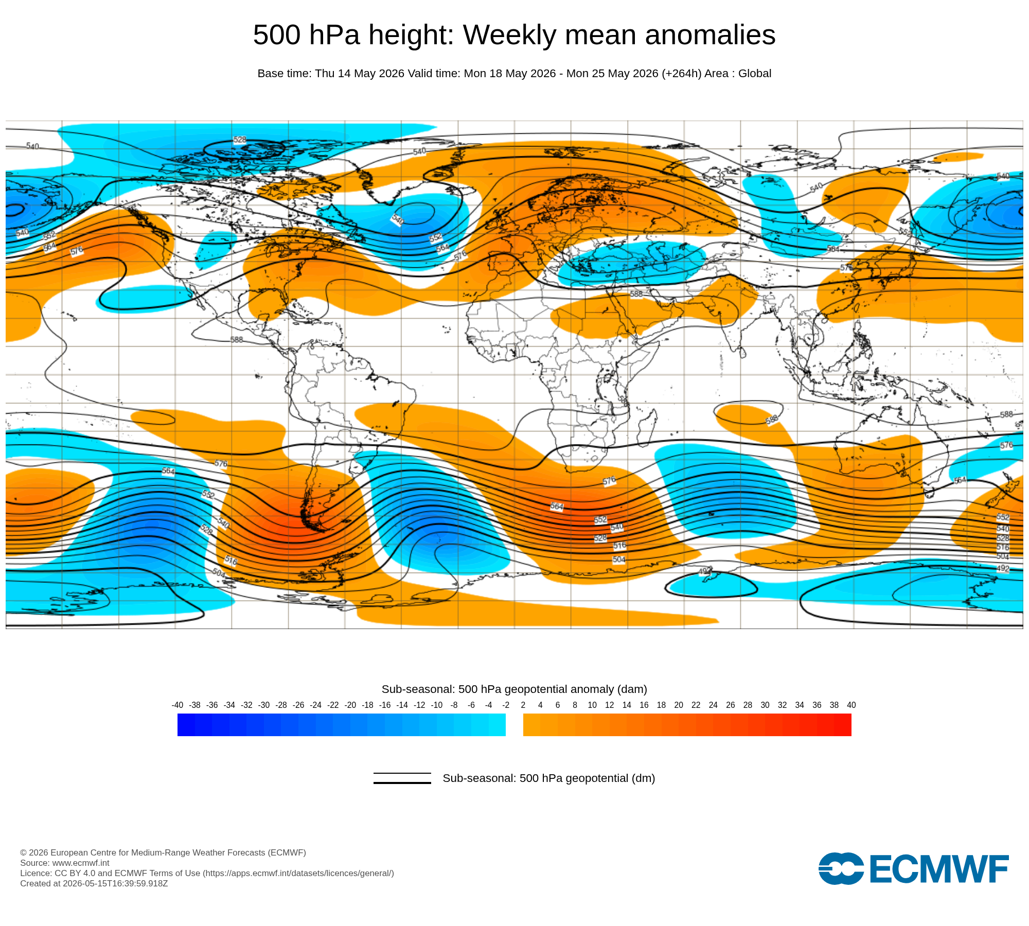
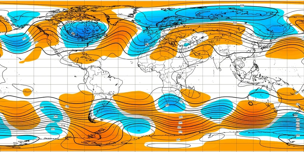
You can see the general outline of the May El Niño 500 mb composite taking shape with alterations probably due to the competing marine heatwaves. The coming near to record May heatwave forecast for the East next week is much warmer than we typically see with such strong developing El Niños. Stronger Southeast ridge could be a function of the weaker RONI relative to ONI and more general subtropical ridging adding a more Niña-like flavor to the mix. The May Western North America El Niño ridge is located a little further SW than usual with the weaker Baja trough than they typically see. May 4th to 11th strong Nino ridge in SW Canada and Aleutian low north of Hawaii Forecast May 18th to 25th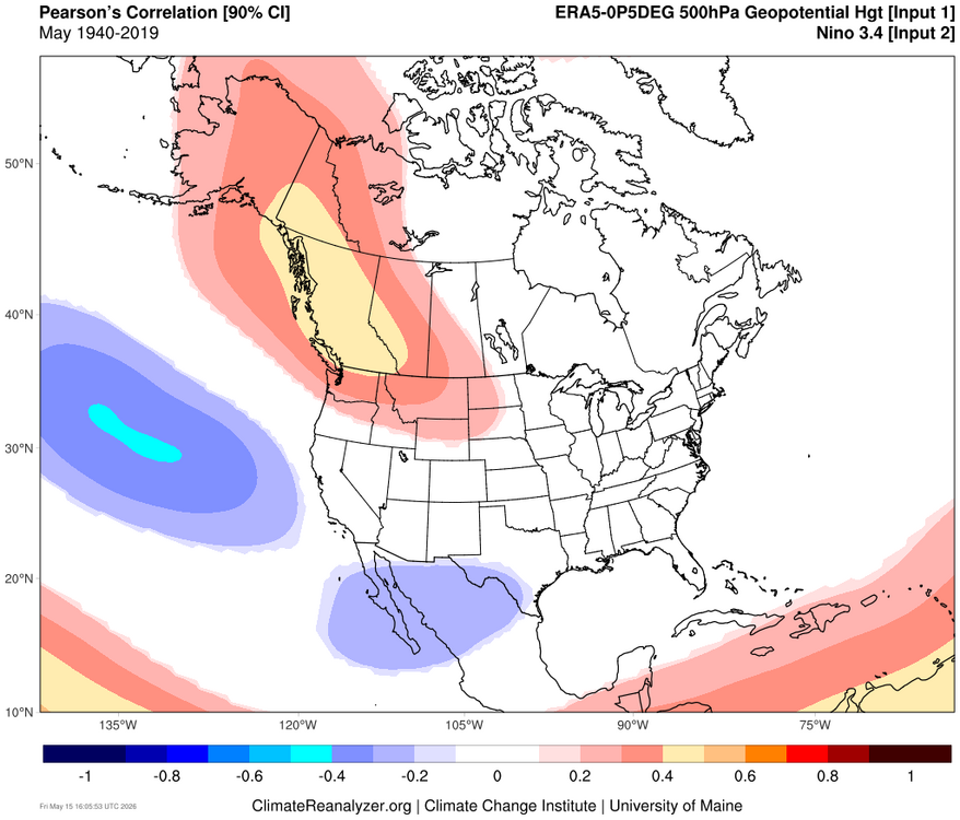

-
GFS has backed off a lot, but still has a few inches for the Palmer Divide and foothills. NAM also has it. Waiting for the 12z Euros to kick off.
-

Central PA Spring 2026 Discussion/Obs Thread
TheDreamTraveler replied to Voyager's topic in Upstate New York/Pennsylvania
Main thing that sucks about it hitting 95 for 2 days straight this early is the pool water is nowhere near warm enough to even take a dip in lmao especially with how cold its been it hasn't had much time to heat up -

Winter 25-26 (All Snowfall Maps & Season Total)
Sey-Mour Snow replied to The 4 Seasons's topic in New England
Pretty cool site thanks! - Today
-
Sun
-
Low of 48 today. Had to wear a jacket on our dog walk. Might be the last 40's we see this spring.
-

2026-2027 Strong/Super El Nino
snowman19 replied to Stormchaserchuck1's topic in Weather Forecasting and Discussion
^ “#ElNiño is taking over the global atmosphere. We're gonna get a brief spat of trade winds over the East Pacific due to an Equatorial Rossby Wave, followed by another large WWB as the MJO traverses back into the Pacific. Models are showing low-frequency forcing setting up over the East/Central Pacific. Looking like a very strong, classic, coupled, canonical +ENSO event starting.“ -

E PA/NJ/DE Spring 2026 Obs/Discussion
RedSky replied to PhiEaglesfan712's topic in Philadelphia Region
That was an anomalous heavy frost i hit 32F There's a big difference between 32F and 25F low -
What's the latest you've seen snow there? I don't think I've seen it more than a day or two after Mother's Day here.
-
2.04"
-

2026-2027 Strong/Super El Nino
A-L-E-K replied to Stormchaserchuck1's topic in Weather Forecasting and Discussion
get ready 2 torch -

2026-2027 Strong/Super El Nino
LakePaste25 replied to Stormchaserchuck1's topic in Weather Forecasting and Discussion
My cool/wet summer for the great lakes will go up in flames unless we start seeing this -
The other day was nuts with gusts near 50mph for a few hours. The resulting sandstorm will keep people off the beach regardless. When the sand is dry and winds are over 40 you have to be insane to be on the beach. .
-
You definitely value heat more than me, so I understand your reasoning. I hate the heat. I only like 90+ when I'm at the beach. Otherwise, it's annoying. I do wish we could have more cool and sunny days, but this time of year, cooler weather usually indicates broad troughing or shallow cool from back door fronts. Can't have the cake and eat it too, so I get it. Alas, we also need rain, so getting warm and humid can at least open the door for convection. On to summer I suppose!
-
The one big event, Jan 25-27, parlayed a modest 0.77" LE into 19.6" of fluff, ratio 25:1. Next biggest was 8.5" on Christmas Eve. Only once before have I recorded a storm of 15"+ with ratio above 16:1, at Fort Kent in December 1981 - 15.5"/0.68" for 23:1
-
Brutal
-
-

Central PA Spring 2026 Discussion/Obs Thread
WmsptWx replied to Voyager's topic in Upstate New York/Pennsylvania
Dear Christ I hope that was the end of the gloomy weather. Seeing the clear sky this morning when waking up lifted my spirits, but also made signing into work difficult. -

2026-2027 Strong/Super El Nino
Stormchaserchuck1 replied to Stormchaserchuck1's topic in Weather Forecasting and Discussion
It will probably go Super, I just don't think it will be an all time record breaking event on the RONI. Were also not seeing a +PNA, or -NPH in the next 15 days.