All Activity
- Past hour
-

January 2026 Medium/Long Range Discussion
nw baltimore wx replied to snowfan's topic in Mid Atlantic
Just a thought, and although I’m not superstitious, but jokes about Uccellini may bring bad karma. I mean, why risk it? -
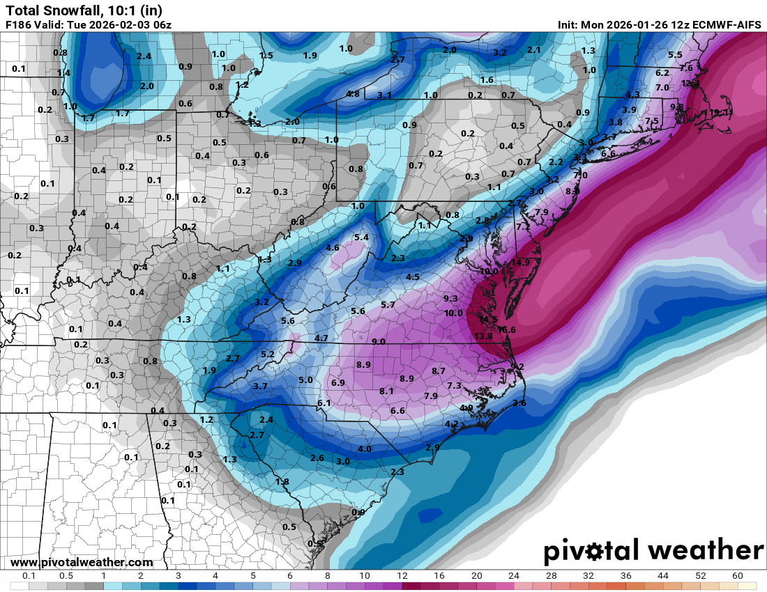
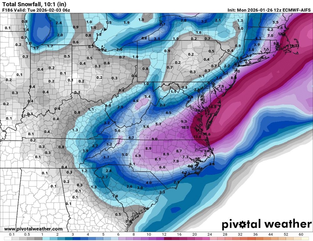
Here's AIFS verbatim. Probably add 50% to the totals to account for extremely good ratios.
-
Man you walk slow
-

E PA/NJ/DE Winter 2025-26 Obs/Discussion
Newman replied to LVblizzard's topic in Philadelphia Region
The storm almost becomes warm core secluded with intense CAA/N winds on the western side of the system. Plus when it becomes vertically stacked, it occludes and you lose that mid-level WAA. Such an intense system would have an intense thermal contrast and there'd be a CCB/fronto band on the western side that helps to cool the column as well. -
Gonna do a temp breakdown along with confirmation for my HMP Weather Central location 5pm-25 7pm-20 9pm-17 11pn-14 1am 11 Overnight low-6
-
I'm expecting the fam up north to get another dumping while we get nothing so I'll be pleasantly surprised if anything happens.
-
WB 12Z EPS compared to 0Z; east shift but we have time to reek back in.

-

Pittsburgh/Western PA WINTER ‘25/‘26
Burghblizz replied to Burghblizz's topic in Upstate New York/Pennsylvania
This presentation tells the story a little better than that other one they had -
It’s so lol
-
Its a miss to the east.
-
Any AI models posted? For 12z -maybe I missed it but I'm reading through and I don't see anything about AI models
-

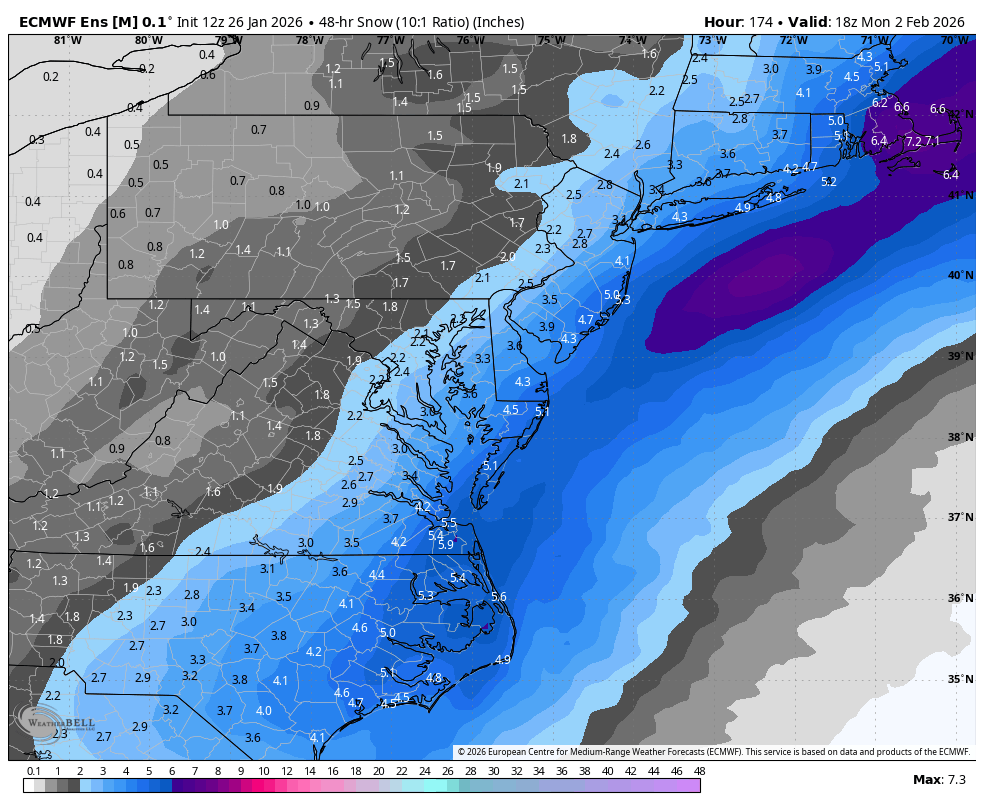
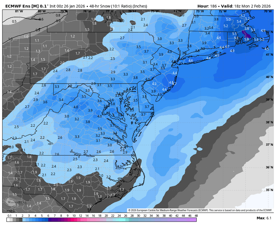
Possible coastal storm centered on Feb 1 2026.
ORH_wxman replied to Typhoon Tip's topic in New England
24h QPF on ensembles....the total would actually be a bit more though since the timing isn't the same on all the members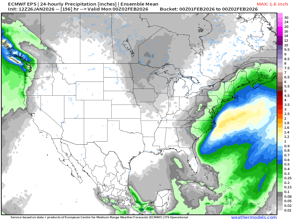
-
He’s probably right, but also is a weenie. His post for the last storm were unbearable.
-

The “I bring the mojo” Jan 30-Feb 1 potential winter storm
BornAgain13 replied to lilj4425's topic in Southeastern States
Model waffles will continue for the next couple of days before honing in on a scenario. -
 I wonder why the outerbanks got so little? Warm air or dry slot? I thought the 80 storm was SUPER cold?? I was only 4 and lived in Wilson...I slightly remember it.
 -
Went out and there are tree limbs down all over. You can walk on the top of the snow without going through. Governor of Maryland put out for people to stay off the roads.
-
Csnavywx, Is this a Triple Phaser? To my untrained eyes it sure looks like one. If it walks like a duck, talks like a duck...
-
The 12z GEPS is further back w/ the surface high pressure over TX than it was at 12z. The 12z Euro is further east w/ the surface high pressure over TX than it was at 6z. That seems to be a pretty significant difference. The amount of hp over the top in New England is also important. The 12z Euro had more there than compared to 6z...and that may well have shunted the moisture to the coast.
-

January 24-26: Miracle or Mirage OBS Thread!
Snowciopathic Snow Bro replied to Jebman's topic in Mid Atlantic
Amen. Using a spade here to jackhammer from the top, then get underneath to lever up the ice blocks, some of which are 3" thick. There's powder underneath, so the regular snow shovel does come in handy for that. A broom takes care of the remaining pixie dust layer to ensure that anyone walking on it doesn't compress leftovers to ice. Amazingly, the asphalt and concrete surfaces are totally dry underneath all of this stuff! Definitely a multiday project for us geezers, lol. -
(002).thumb.png.6e3d9d46bca5fe41aab7a74871dd8af8.png)
E PA/NJ/DE Winter 2025-26 Obs/Discussion
ChescoWx replied to LVblizzard's topic in Philadelphia Region
All I look at is the ensembles and the latest European indeed shows accumulating snows back through our area....that is all that matters not any one operational run. Suspect another busy tracking week ahead! Stay warm my friends!! -
12.1” here in Williamsburg Brooklyn 23.7” year to date
-
Major west lean on the EPS
-

Richmond Metro/Hampton Roads Area Discussion
overcautionisbad replied to RIC Airport's topic in Mid Atlantic
Sure, no ill will, but jealousy for sure as this will be God knows how many times now since 2000. My gut here is congrats to Tidewater once again... At the end of the day I'm just happy the freezing rain didn't pan out yesterday, honestly -

1/24-1/25 Major Winter Storm - S. IL, IN, and OH
Roger Smith replied to A-L-E-K's topic in Lakes/Ohio Valley
May have been two calendar days like an overnight storm? Toronto has never had a 20" calendar day storm (I have not had time to check the latest on yesterday) but it has three or four overnight 20 to 23 inch storm totals. I recall doing a study on all 8.0" two day totals for Toronto (hundreds of data points) and about half of them had a significant amount on a second consecutive day. So only about half of all snowstorms there manage to occur all within one calendar day, or mostly if we eliminate the 0.1 and 0.2 add-ons. A few storms require three calendar days to play out to their totals but I never did a census on those because in a fast-moving pattern there can easily be two separate events contained in three days of snowfall data. -
 12.1” storm 23.7” season