SleetStormNJ
-
Posts
764 -
Joined
-
Last visited


-
We've had good/bad with both patterns, lot of correlative/impact factors at play really.
-
Getting spoiled or no mas for a snowpack refresher in late February/early March. Oh the winter.
-
They are doing official measurements. Measuring after hours of compaction is not accurate.
-
Indeed - they also met it again this morning I believe - so technically a two day blizzard verification.
-
Take it easy and stay safe. Its a wet base/powder mix really. Need to heed my own advice, I'm due for back/neck surgery on Thursday. Just glad this monster came before and not during/right after.
-
HRRR looks like it may have nailed this big outer band placement.
-
We will have to see if the HRRR depiction of that moderate band til 1pm holds to fruition.
-
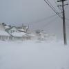
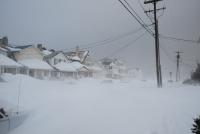
I am in Union County and we've been in moderate snow with heavy bursts pretty much all morning. Most locations are going to push 20-26 in the Essex, Union, Middlesex, Monmouth corridors.
-
Makes sense - I'm just to SW in Union County, updated reports as of 8:50am have between 16-22 inches in most spots.
-
I don't see anyway EWR doesnt get past 2 feet clean based on their 18-ish report around 630-7 - maybe even 26-ish.
-
Most locales in Central/Eastern Union County have anywhere from 14-20 inches already.
-
Best fronto banding still to come once the low explodes off Jersey/LI.
-
We're seeing some drifting now so will be tough to stay on the board measurements, and I have to be on call for work, so this might be measuring call-out duty - hopefully some other folks in the Monmouth/Middlesex, Union, Essex crew can manage. I think we are in for a snow-pile night still by us - think we end up with 16-22 across the area.
-
I don't know how you have 3.5, when I am right by and already have just over 5 inches - 5.2 actually to be exact.
-
It was locked in on 2016, off a bit with the Euro on the 2015 one year prior.