All Activity
- Past hour
-
https://x.com/wxmvpete/status/2079688400559345958?s=20
-
Tornado on the ground near Youngstown right now
-
Holy shit
-

2026-2027 Super El Nino
mitchnick replied to Stormchaserchuck1's topic in Weather Forecasting and Discussion
Especially considering the quality forecasts they can get on this Board. -
I think all of wake is over 4” for the month with Raleigh-north over 8”
-
Houston better look out for lots of rain. Buda, not so much. Bertha's center of circulation is now progged to pass well east of me. This means no rain and highs around 108 degrees ambient, not counting humidity. Better build a lot of Arks Houston and Louisiana! You're gonna need 'em! Not to worry. We got us a record Nino on tap and strengthening and I'll get plenty of flooding rains between now and May 2027.
-

2026-2027 Super El Nino
GaWx replied to Stormchaserchuck1's topic in Weather Forecasting and Discussion
Hasn’t it been the case just about every year for a good while that there are numerous clickbait mets on YouTube calling for a snowy winter in the E US for whatever reason they come up with that year? They always seem to do this. What’s extra funny is that the bulk of them usually also have mild and limited snow in the SW US because they don’t live out there. By having mild/snowless on their maps, they probably think that makes them look objective as opposed to having cold/snowy just about everywhere lmao. The whole thing is laughable. -
After having a pop up earlier today over here we have seemed to landed in a rain hole. Did just have that waterspout going into Cape May that prompted the warning. Glad we decided to take our trip to Cape May on Thursday as it looked to be going right into the Ferry terminal over there. Checking in at home though and getting some decent storms rolling through again. Station showing .67” with more to come. Will help the younger Ms. J not have to water my deck plants as much.
-
Tornado Warning up BULLETIN - EAS ACTIVATION REQUESTED Tornado Warning National Weather Service Baltimore MD/Washington DC 638 PM EDT Tue Jul 21 2026 The National Weather Service in Sterling Virginia has issued a * Tornado Warning for... Southwestern Hampshire County in eastern West Virginia... * Until 715 PM EDT. * At 638 PM EDT, a severe thunderstorm capable of producing a tornado was located 8 miles southwest of Romney, moving east at 30 mph. HAZARD...Tornado. SOURCE...Radar indicated rotation. IMPACT...For those in the direct path of a tornado touchdown, flying debris will be dangerous to those caught without shelter. Damage to roofs, siding, and windows may occur. Mobile homes may be damaged or destroyed. Tree damage is likely. * This tornadic thunderstorm will remain over mainly rural areas of southwestern Hampshire County, including the following locations... Augusta, Frenchburg, Kirby, Junction, Shanks, and Purgitsville. PRECAUTIONARY/PREPAREDNESS ACTIONS... TAKE COVER NOW! Move to a basement or an interior room on the lowest floor of a sturdy building. Avoid windows. If you are outdoors, in a mobile home, or in a vehicle, move to the closest substantial shelter and protect yourself from flying debris. && LAT...LON 3931 7858 3913 7865 3925 7895 3931 7891 3933 7889 3933 7886 TIME...MOT...LOC 2238Z 288DEG 24KT 3927 7888 TORNADO...RADAR INDICATED MAX HAIL SIZE...<.75 IN
- 1,400 replies
-
- 1
-

-
- severe
- thunderstorms
- (and 7 more)
-
 All falling apart as it gets up here. 0.70” month to date here and 1/3 of that was to start the month.
 -

2026 Mid-Atlantic Severe Storm General Discussion
AlexD1990 replied to Kmlwx's topic in Mid Atlantic
It's also got a pretty good couplet -

2026 Mid-Atlantic Severe Storm General Discussion
George BM replied to Kmlwx's topic in Mid Atlantic
June 5, 2024 in northern MD.- 1,400 replies
-
- 1
-

-
- severe
- thunderstorms
- (and 7 more)
-
Storm right behind it (near Romney) just got svr warning with tor possible tag
-

E PA/NJ/DE Summer 2026 Obs/Discussion
The Iceman replied to PhiEaglesfan712's topic in Philadelphia Region
Hyped severe weather underdelivers like 99% of the time in this area. Our best severe events are always like a random marginal or slight risk that over performs. -
.67" today, 8.62" for the month.
-

Central PA Summer 2026 Discussion/Obs Thread
Mount Joy Snowman replied to Voyager's topic in Upstate New York/Pennsylvania
A complete dud down this way with respect to any type of meaningful rain or severe. -

2026 Mid-Atlantic Severe Storm General Discussion
NorthArlington101 replied to Kmlwx's topic in Mid Atlantic
Germantown-area TOR 2 years ago, maybe? Not sure I’ve got the year right- 1,400 replies
-
- 1
-
-
- severe
- thunderstorms
- (and 7 more)
-

2026 Mid-Atlantic Severe Storm General Discussion
SnowenOutThere replied to Kmlwx's topic in Mid Atlantic
Think I'll get to the herndon metro tower as my chase spot. Looks to get a good view as it comes in.- 1,400 replies
-
- 3
-
-
- severe
- thunderstorms
- (and 7 more)
-
2026 Mid-Atlantic Severe Storm General Discussion
AlexD1990 replied to Kmlwx's topic in Mid Atlantic
Confirmed large and dangerous tornado- 1,400 replies
-
- 1
-
-
- severe
- thunderstorms
- (and 7 more)
-
Now a PDS warning Severe Weather Statement National Weather Service Baltimore MD/Washington DC 629 PM EDT Tue Jul 21 2026 VAC069-212245- /O.CON.KLWX.TO.W.0017.000000T0000Z-260721T2245Z/ Frederick VA- 629 PM EDT Tue Jul 21 2026 ...A TORNADO WARNING REMAINS IN EFFECT UNTIL 645 PM EDT FOR SOUTH CENTRAL FREDERICK COUNTY IN NORTHWESTERN VIRGINIA... At 629 PM EDT, a confirmed large and extremely dangerous tornado was located near Star Tannery, or 10 miles west of Winchester, moving east at 20 mph. This is a PARTICULARLY DANGEROUS SITUATION. TAKE COVER NOW! HAZARD...Damaging tornado. SOURCE...Radar confirmed tornado. IMPACT...You are in a life-threatening situation. Flying debris may be deadly to those caught without shelter. Mobile homes will be destroyed. Considerable damage to homes, businesses, and vehicles is likely and complete destruction is possible. Locations impacted include... High View Manor and Wilde Acres. PRECAUTIONARY/PREPAREDNESS ACTIONS... To repeat, a tornado is on the ground. To protect your life, TAKE COVER NOW! Move to a basement or an interior room on the lowest floor of a sturdy building. Avoid windows. If you are outdoors, in a mobile home, or in a vehicle, move to the closest substantial shelter and protect yourself from flying debris. && LAT...LON 3918 7819 3907 7827 3915 7841 3918 7839 TIME...MOT...LOC 2229Z 291DEG 18KT 3915 7837 TORNADO...OBSERVED TORNADO DAMAGE THREAT...CONSIDERABLE MAX HAIL SIZE...<.75 IN $$ DHOF
-
2026 Mid-Atlantic Severe Storm General Discussion
NorthArlington101 replied to Kmlwx's topic in Mid Atlantic
PDS -
2026 Mid-Atlantic Severe Storm General Discussion
SnowenOutThere replied to Kmlwx's topic in Mid Atlantic
PDS warning issued. When is the last time we've had that -

2026 Mid-Atlantic Severe Storm General Discussion
wxmeddler replied to Kmlwx's topic in Mid Atlantic
Very obvious TDS west of Winchester. LWX has gone radar confirmed.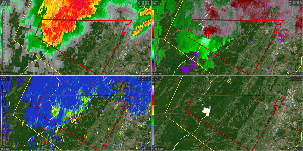
-
Um uh oh Severe Weather Statement National Weather Service Baltimore MD/Washington DC 629 PM EDT Tue Jul 21 2026 VAC069-212245- /O.CON.KLWX.TO.W.0017.000000T0000Z-260721T2245Z/ Frederick VA- 629 PM EDT Tue Jul 21 2026 ...A TORNADO WARNING REMAINS IN EFFECT UNTIL 645 PM EDT FOR SOUTH CENTRAL FREDERICK COUNTY IN NORTHWESTERN VIRGINIA... At 629 PM EDT, a confirmed large and extremely dangerous tornado was located near Star Tannery, or 10 miles west of Winchester, moving east at 20 mph. This is a PARTICULARLY DANGEROUS SITUATION. TAKE COVER NOW! HAZARD...Damaging tornado. SOURCE...Radar confirmed tornado. IMPACT...You are in a life-threatening situation. Flying debris may be deadly to those caught without shelter. Mobile homes will be destroyed. Considerable damage to homes, businesses, and vehicles is likely and complete destruction is possible. Locations impacted include... High View Manor and Wilde Acres. PRECAUTIONARY/PREPAREDNESS ACTIONS... To repeat, a tornado is on the ground. To protect your life, TAKE COVER NOW! Move to a basement or an interior room on the lowest floor of a sturdy building. Avoid windows. If you are outdoors, in a mobile home, or in a vehicle, move to the closest substantial shelter and protect yourself from flying debris. && LAT...LON 3918 7819 3907 7827 3915 7841 3918 7839 TIME...MOT...LOC 2229Z 291DEG 18KT 3915 7837 TORNADO...OBSERVED TORNADO DAMAGE THREAT...CONSIDERABLE MAX HAIL SIZE...<.75 IN
-

2026 Mid-Atlantic Severe Storm General Discussion
canderson replied to Kmlwx's topic in Mid Atlantic
29 right past E City is partially underwater. Ask me how I know.