All Activity
- Past hour
-

2026-2027 Super El Nino
bluewave replied to Stormchaserchuck1's topic in Weather Forecasting and Discussion
Big shift to a negative tendency last few days as we see a more Niña-like pattern again for a time near the end of the month.
-
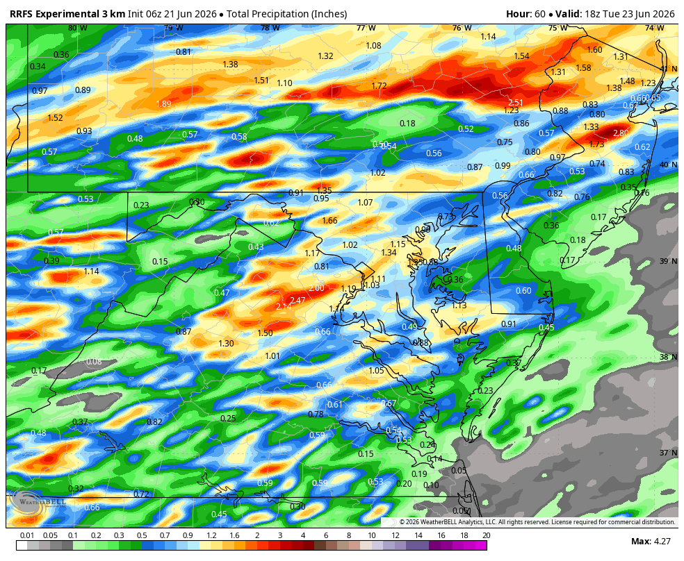
00z HRRR is wetter for many, but no severe. I'll take it.
-

Central PA Summer 2026 Discussion/Obs Thread
mahantango#1 replied to Voyager's topic in Upstate New York/Pennsylvania
US National Weather Service State College PA Favorites ·teSdronops6g5606i21i856gif3im7269a1u63t2cff0aa30mluai700ih91 · Sun - June 21, 2026 @ 6 AM EDT: We'll have pleasant weather to end the holiday weekend with comfortably warm temperatures, low humidity and plenty of sun. Humidity will significantly increase late tonight and Monday as a strong southerly flow develops ahead of low pressure headed our way from the Midwest. In additional to periods of steady rain, the risk for severe thunderstorms will develop across the Southeastern half of the state. There will also be a tornado threat with the stronger storms. A more southern track to the area of low pressure would decrease the region where severe thunderstorms are possible. -
Mesos are way north up here….globals SNE. Interesting.
-
The wait is over. After today, shorter days until late December. One thing I'm noticing is, despite chances for AN temps among some models, I'm not seeing any all out furnace runs...not yet at least. Happy Fathers Day to all the fathers out there.
-
Happy Summer! Actually, daylight starts to shorten less than a second today as sun angle heads back toward winter.....sunrise: 5:42am; sunset 8:40pm in Frederick.
-
Looks wet tomorrow.
- Today
-
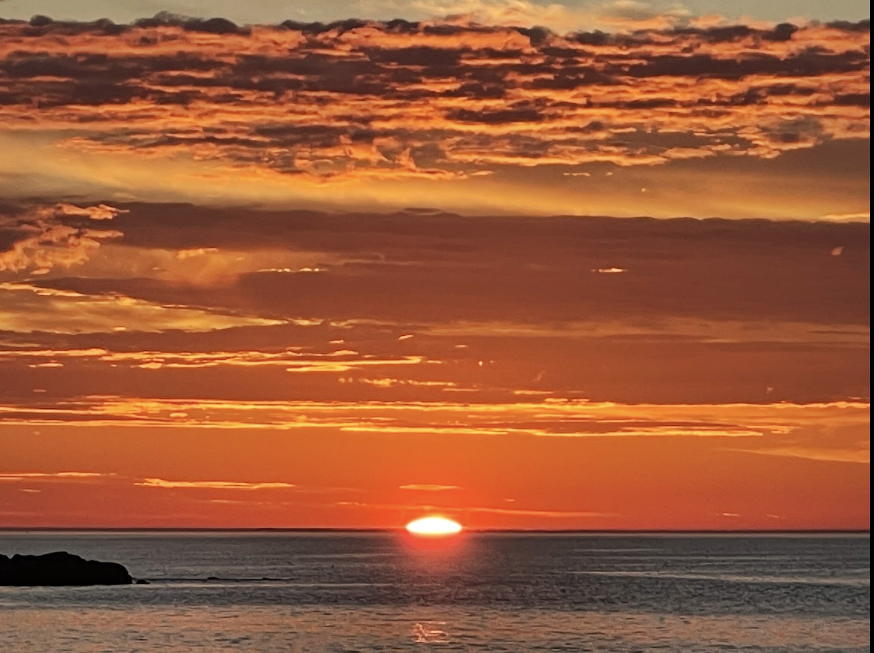
Father’s Day / Solstice sunrise this morning in Rye, NH

-
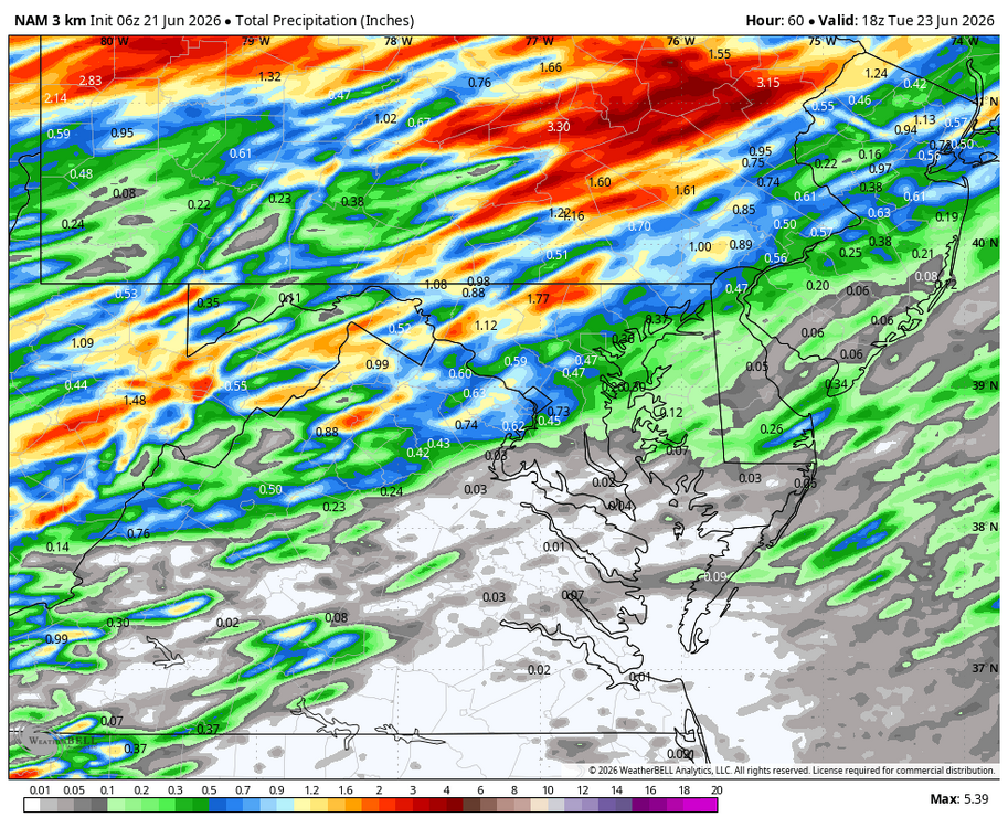
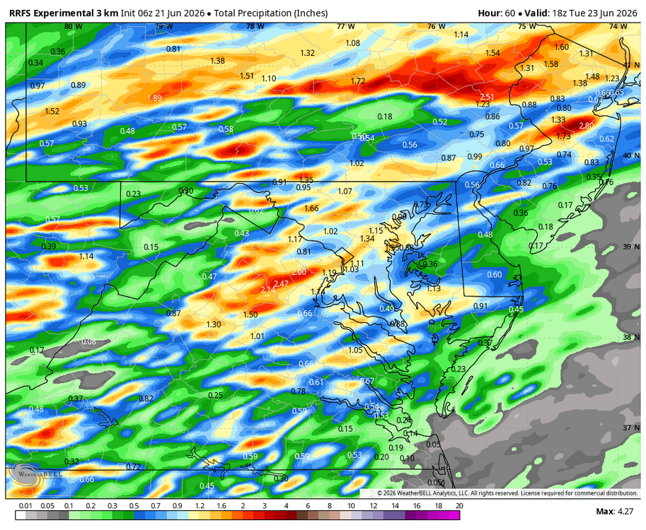
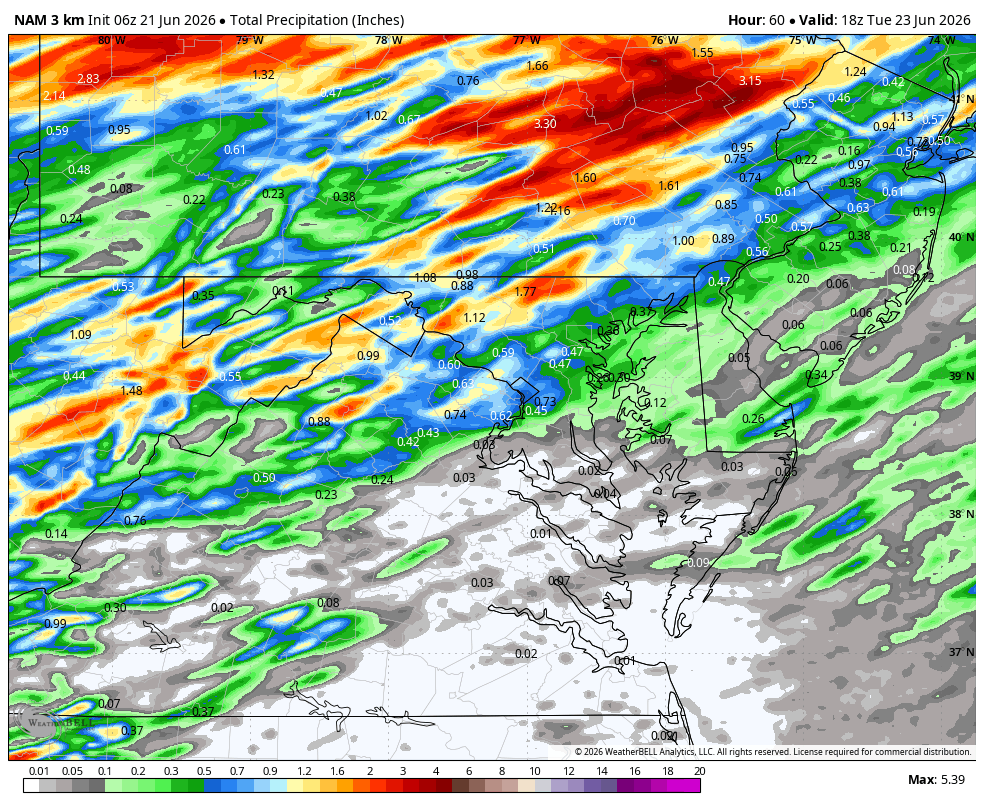
WB 6Z 3K NAM and RRFS
-
Not for long
-
NAM trended south over our area for heavy rain tomorrow. 1-2" across the area. Fingers crossed
-

2026-2027 Super El Nino
mitchnick replied to Stormchaserchuck1's topic in Weather Forecasting and Discussion
Great post! Averaging out Dec-Feb, it doesn't really look too much different from the NMME in the east. I don't care about its forecast for the rest of the world. -
0Z Canadian and GFS- as we move closer to the event once again the trend is dryer
-

2026-2027 Super El Nino
40/70 Benchmark replied to Stormchaserchuck1's topic in Weather Forecasting and Discussion
I'm not really using 1986-1987 per se, but like that overall progression......mild December prior to mid season shift colder. -
2026-2027 Super El Nino
40/70 Benchmark replied to Stormchaserchuck1's topic in Weather Forecasting and Discussion
Nice post, raindance. I'm not sold on a non-winter, either. -

2026-2027 Super El Nino
raindancewx replied to Stormchaserchuck1's topic in Weather Forecasting and Discussion
The only year that has cold ENSO-->warm ENSO, very +NAO, very -WPO in March is 1986. For winter, that's - +NAO & AO early (Oct-Dec), -NAO late (Jan-Mar) -WPO early (Oct-Dec), +WPO late (Jan-Mar) +PNA (Dec-Mar) -EPO (Jan-Feb), +EPO (Mar) Signal Oct Nov Dec Jan Feb Mar NAO + + + - - - AO + + + - - - PNA + - + + + + EPO + + ? - - + WPO - - - + + + That's a good pattern for storms nationally, volatile but warm for temps for most of the USA. +NAO - For Oct, warm Plains and East. Neutral West & Deep South for Oct. Warm signal strongest over Missouri. For Nov, warm signal strongest SE US, warm signal eastern 1/3 of the USA. Weak cold signal TX to WA state. +AO is similar in Oct-Nov, but a broader warm signal for the Midwest in October. -NAO/AO in Jan-Mar - cold everywhere. Strongest in March. +PNA - very warm signal for the Western US in October. Weak cold signal in the Eastern US. Netural Plains. -PNA Nov - cold signal Western and Northern US, warm signal Southern & Eastern US. Strong signal Northwest and Deep South. +PNA Dec-Mar. Broadly cold for the South and East in Dec, Jan, Feb, Mar. But strongest signal and widest significant spatial correlation in Nov-Jan. +EPO is a cold signal for the entire US east of the West Coast in Oct-Nov. Strongly so east of the Rockies. -EPO is a strong warm signal for the US outside the Southwest in Jan-Mar, especially in Jan/Mar. Weak cold signal in the SW Jan/Mar, strong in Feb. -WPO Oct is very cold in the middle 2/3 of the US, neutral coasts (think Oct 2020). Cold east for Nov - weak. Strong cold signal NE US in Dec. +WPO is a weak cold SW/warm NE signal in Jan, and then much stronger for both components in Feb/Mar. These are the years with the 1986-87 projection for the main signals. Oct: +NAO, +PNA, +EPO - WPO, El Nino: 1957, 1963, 1965, 1969, 1976, 1986, 1987, 2015, 2018 Nov: +NAO, -PNA, +EPO, -WPO, El Nino: 1982, 1986, 2019 Dec: +NAO, +PNA, ?EPO, -WPO, El Nino: 1986, 2014 Jan: -NAO, +PNA, -EPO, +WPO, El Nino: 1957, 1986, 1991, 2002, 2009, 2015 Feb: -NAO, +PNA, -EPO, +WPO, El Nino: 1951, 1963, 1976, 1986, 1997, 2009 Mar: -NAO, +PNA, +EPO, +WPO, El Nino: 1957, 1986, 1987, 2023 Honestly looks...plausible? Something like this overall - it'd be a 0-1F colder nationally for Jan-Mar v. Dec-Feb but very similar. -
When the cell was maxing near S Wey. earler
-
.thumb.jpg.6a4895b2a43f87359e4e7d04a6fa0d14.jpg)
Central PA Summer 2026 Discussion/Obs Thread
Yardstickgozinya replied to Voyager's topic in Upstate New York/Pennsylvania
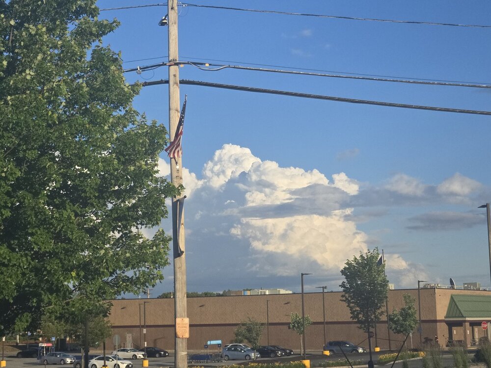
I can smell the rain , but I'm left high and dry at home so far. The ground was still wet when I left Mechanicsburg, but it was completely dry when I got home. I'm pretty sure that I heard one rumble of thunder while out in my shed about 25 minutes ago, but I didn't see any lightning and nothing was detected. Some rain before the wild raspberries start to abort and lightning bugs peak, sure as hell would be nice. Some of the main things that I grade my summer on are convection, heat, humidity, frogs, lightning bugs and raspberries all are in danger of being extremely lackluster, this summer, and it's really starting to f****** p*** me off. -
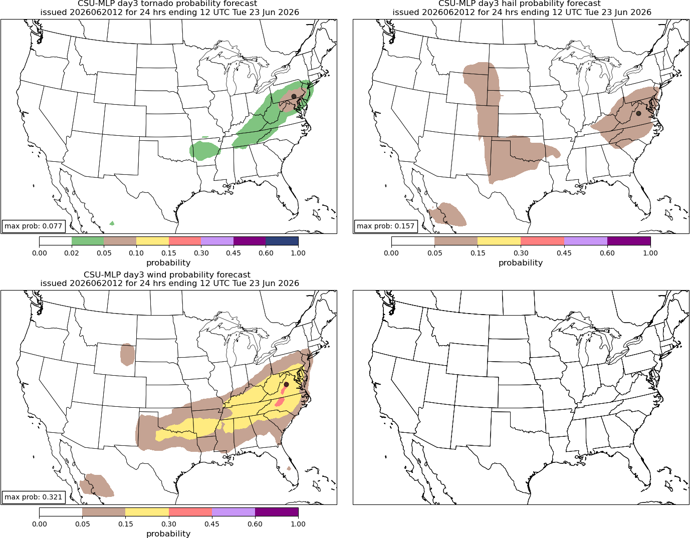
Probabilities of all severe hazards seemed to go up significantly between the 6z and 12z runs. Definitely worthy of a watch for the next couple of days.

.thumb.png.77c9dc49b2ce92bc38e4f31af79c039f.png)
- 808 replies
-
- 2
-

-

-
- severe
- thunderstorms
- (and 7 more)
-
My somewhat suspect PWS gauge has 2.66” this week. Stein would be welcome to visit for a short time up here.
-
Another 90F at DCA today.
-
same here. Everything is crunchy.
-

Central PA Summer 2026 Discussion/Obs Thread
canderson replied to Voyager's topic in Upstate New York/Pennsylvania
Brb gonna go buy a lottery ticket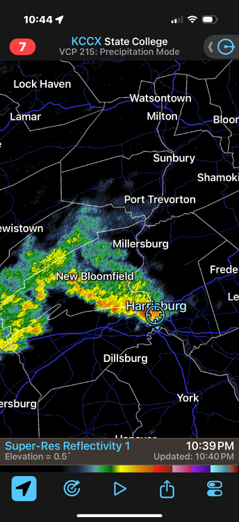
-
Central PA Summer 2026 Discussion/Obs Thread
canderson replied to Voyager's topic in Upstate New York/Pennsylvania
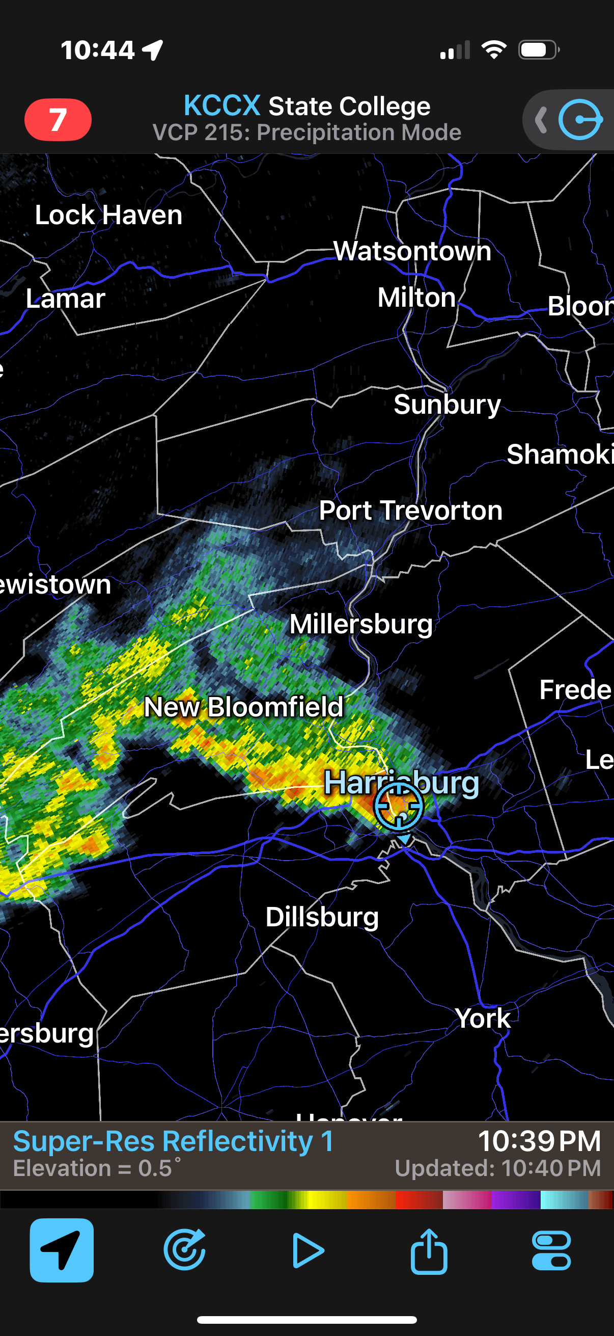
Holy smokes - some actual rain! -

Central PA Summer 2026 Discussion/Obs Thread
TheDreamTraveler replied to Voyager's topic in Upstate New York/Pennsylvania
Okay nevermind it came back pouring again lol


.thumb.gif.f92b16c631a1d15d405ed77b33f0710d.gif)


.png.5b3b1af0e77188154c10940bebb58281.png)