All Activity
- Past hour
-
Yeah you’re teasing, but knowing the climo and the track of the storm at this time of year and with antecedent frigid air, I’d take my chances with a 979 off the coast in a heartbeat.
-

Rise of the Machines: January 18-19 Winter Storm Obs Thread
Go Kart Mozart replied to WxWatcher007's topic in New England
Damn we're close. I am dead nuts center of Trumbull. -
The suppression is overdone.
-

Rise of the Machines: January 18-19 Winter Storm Obs Thread
EastonSN+ replied to WxWatcher007's topic in New England
I am about 1 mile north of the Merrit. About half mile west of Trumbull. -

Rise of the Machines: January 18-19 Winter Storm Obs Thread
WinterWolf replied to WxWatcher007's topic in New England
Especially 8-9 days ago it looked like there was nothing in the pipeline but dry. Nice turn around from that idea. Not too shabby at all. -

First Legit Storm Potential of the Season Upon Us
weathafella replied to 40/70 Benchmark's topic in New England
RIP Messenger -

Rise of the Machines: January 18-19 Winter Storm Obs Thread
amarshall replied to WxWatcher007's topic in New England
Flipped to rain on the coast ugh . -

First Legit Storm Potential of the Season Upon Us
ORH_wxman replied to 40/70 Benchmark's topic in New England
Not very good in short term. It def kicked the operational’s butts though in that D3-5 period. -

January 18th Back Door NW Trend Snow OBS Thread
Kevin Reilly replied to Mikeymac5306's topic in Philadelphia Region
Looks about right I I think if you are looking at the current radar. Let's just see what pops but obviously the favored areas are Northeast towards the North Jersey coast that will be the best mix of cold air coming southeast meeting up with the storm scrapping the coast. -
The 12z GFS is nightmare fuel for mby. Fortunately it's the worst model on the planet currently.
-

January 2026 Medium/Long Range Discussion
StormyClearweather replied to snowfan's topic in Mid Atlantic
-
Rise of the Machines: January 18-19 Winter Storm Obs Thread
Go Kart Mozart replied to WxWatcher007's topic in New England
In what geographic part of Easton are you? -
That's a barrage of hits at day 6/7 and beyond today,coming in from all sides all models.
-

Pittsburgh/Western PA WINTER ‘25/‘26
colonel717 replied to Burghblizz's topic in Upstate New York/Pennsylvania
More snow showers breaking out.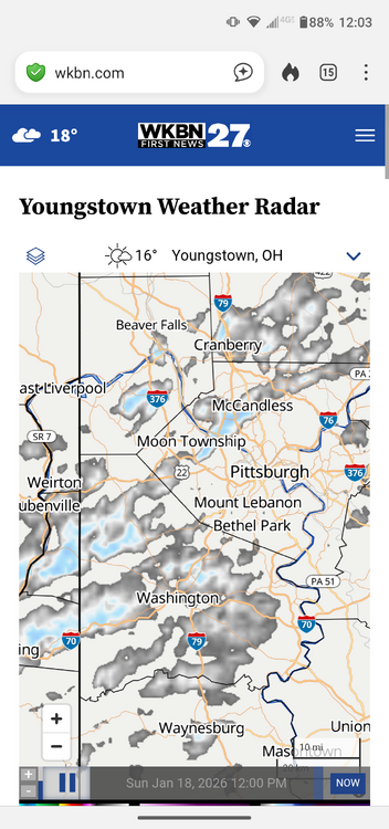
-

January 2026 Medium/Long Range Discussion
nw baltimore wx replied to snowfan's topic in Mid Atlantic
Everyone is a little frustrated by lack of snow. Welcome to the forum. -

E PA/NJ/DE Winter 2025-26 Obs/Discussion
Duca892 replied to LVblizzard's topic in Philadelphia Region
Suppression depression now on 12z GFS for next weekend -
Now bigger flakes too. All snow.
-

Storm potential January 17th-18th
NorthShoreWx replied to WeatherGeek2025's topic in New York City Metro
Gotta like Uncle Joe's! -
Storm potential January 17th-18th
EastonSN+ replied to WeatherGeek2025's topic in New York City Metro
They likely got 0.5 to 1 inch but don't think they measured so it would have melted by the time they do. So in reality 0.5 to 1 inch but they will not count it. -

Storm potential January 17th-18th
sussexcountyobs replied to WeatherGeek2025's topic in New York City Metro
Really? Don't worry. Colder air is seeping in very slowly. Down to 30.8 here, and snow is picking up. It never actually stopped here. Just got real light with tiny flakes for 90 minutes. -
Gfs has ridiculous cold air . Not sure if its overdoing it
-

First Legit Storm Potential of the Season Upon Us
dendrite replied to 40/70 Benchmark's topic in New England
Last 4 runs of the AIFS ENS for the 18z-18z period beginning today. Not that any model has done well, but do we consider this a good performance?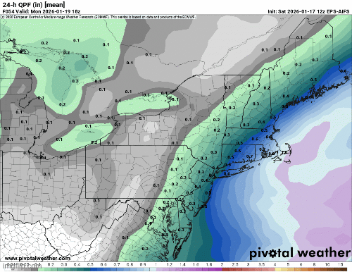
-
Bingo
-

January 2026 regional war/obs/disco thread
Typhoon Tip replied to Baroclinic Zone's topic in New England
Hopefully this happens barely 3 days after the deepest season defining arctic nadir pattern...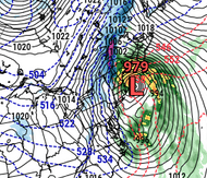
-
I guess you haven't been following the models this winter.


