All Activity
- Past hour
-
No idea just surprised nobody posted.
-

Jan 24-26 Weekend Snow and Sleetfest Model Thread Part Tres
MN Transplant replied to H2O's topic in Mid Atlantic
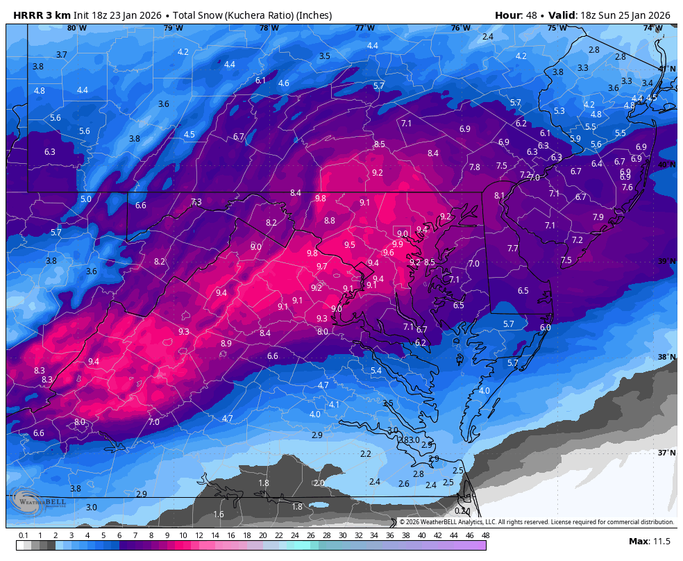
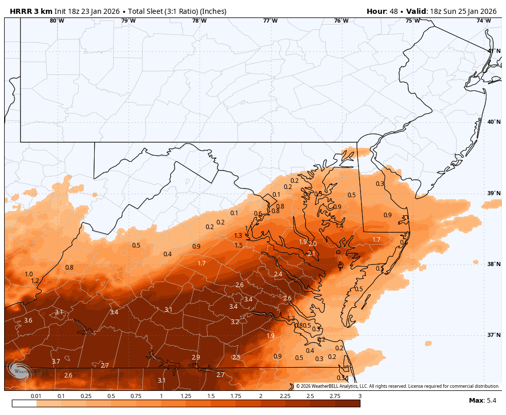
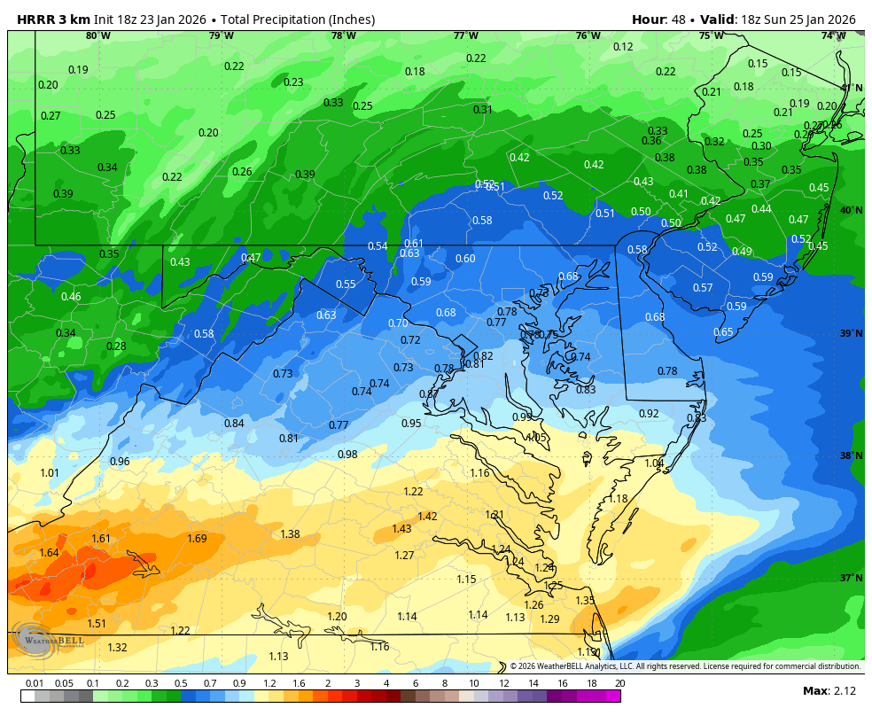
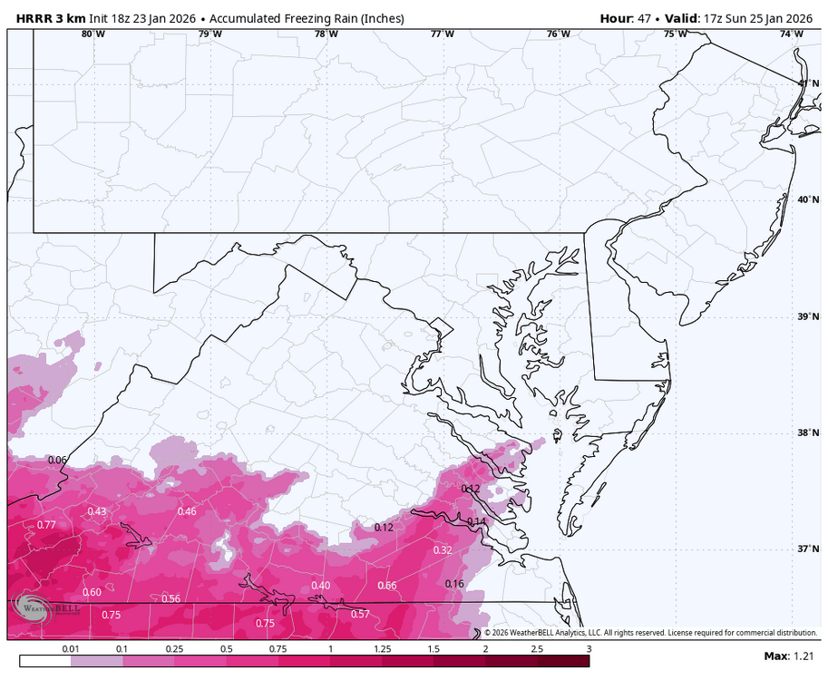
Lord help us all for looking at the HRRR at range, but it is a good 0.70" QPF before the flip in DC. Nice run. -
One of the reasons this is being detected early is probably because the primary shortwave is already an entity over the Pacific east of Japan.
-

Jan 24-26 Weekend Snow and Sleetfest Model Thread Part Tres
SnowGolfBro replied to H2O's topic in Mid Atlantic
And likely 6-12 hours of something frozen falling after the end of the run heh -

Jan 24-26 Weekend Snow and Sleetfest Model Thread Part Tres
Weather Will replied to H2O's topic in Mid Atlantic
HR 48 WB 18Z HRRR, great start!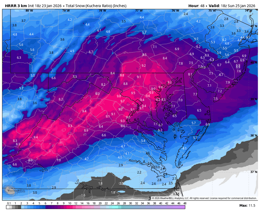


-

Jan 24-26 Weekend Snow and Sleetfest Model Thread Part Tres
Eskimo Joe replied to H2O's topic in Mid Atlantic
18z HRRR is a great run from I-70 north. -

Jan 24-26 Weekend Snow and Sleetfest Model Thread Part Tres
Terpeast replied to H2O's topic in Mid Atlantic
Love the HRRR run. Probably out of its range, but see its trying to start a coastal. -

Central PA Winter 25/26 Discussion and Obs
AccuChris replied to MAG5035's topic in Upstate New York/Pennsylvania
Long range HRRR looks great for 18z Sunday . -

Jan 24-26 Weekend Snow and Sleetfest Model Thread Part Tres
yoda replied to H2O's topic in Mid Atlantic
Yes I know its the 18z HRRR at the end of its run, but note 700-800mb. Doesn't go positive aka above 0c. This is the sounding at DCA -
Of course the HRRR looks like it has some weird low that goes from the Apps to the midstate.
-

January 25-26 Winter Storm Potential
Hurricane Agnes replied to Ralph Wiggum's topic in Philadelphia Region
AmWx WAS EasternWx until 2010 when they re-did the site. I remember the years of the routine of "changing the snow tires" in spring and fall (on 2 different station wagons over the years in the '60s - late-'70s) and keeping a set of chains in the back of the station wagon. Except for the '66 storm, none of that was really needed. The snow drought literally "broke" the year my mom bought a brand new Mercury Zephyr after getting rid of the old station wagon and then a few months later, having some cop car doing a chase on the snowy street, and T-boneing it while it was parked in front of the house. Thank goodness for "all-weather tires" (at least around these parts - the snow zones in the northern U.S. still have those snow tires as I understand). -

Central PA Winter 25/26 Discussion and Obs
Mount Joy Snowman replied to MAG5035's topic in Upstate New York/Pennsylvania
18z HRRR at the end of its run at 1pm on Sunday, with roughly 7-9" on the ground. -

“Cory’s in LA! Let’s MECS!” Jan. 24-26 Disco
HoarfrostHubb replied to TheSnowman's topic in New England
CoastalJr hacked their site -
“Cory’s in LA! Let’s MECS!” Jan. 24-26 Disco
HoarfrostHubb replied to TheSnowman's topic in New England
Probably noon-ish. Might get going quickly -

Possible Record Breaking Cold + Snow Sunday 1/25 - Tuesday 1/27
Stormlover74 replied to TriPol's topic in New York City Metro
Looks great. Snowing nicely at 18z and the mix line still several hours away -

January 25-26 Winter Storm Potential
zenmsav6810 replied to Ralph Wiggum's topic in Philadelphia Region
I'm not sure if frequency of Nor' Easters are exactly a solid metric of climatology. There's so many confounding variables such as ENSO, oscillations factors, not to mention storm subtype classifications that would have to be controlled for to make sense of the data. The occurrence of a snowstorm in CHESCO is too rare and random an event to really make any sort of statistical analysis out of. The one study that once got my attention on a similar matter used a statistical method called bootstrapping (to show an eastward shift in Tornado Alley). This got around the meta-factors and stochastic principle. Its also worth noting that its a much larger area with many more data points than IMBY MECSes. -

Jan 24-26 Weekend Snow and Sleetfest Model Thread Part Tres
Stormchaserchuck1 replied to H2O's topic in Mid Atlantic
18z Hrr again looks like all snow Baltimore-north. Might stay that way for the duration as it looks like it transfers the coastal fast/south again. The RAP and Hrr specialize as short term models, better accuracy within 24-36 hours, but it looks like 12"+ Baltimore north. -
Mid and western areas are just a disaster area most likely if it's correct.
-
-

Jan 24-26 Weekend Snow and Sleetfest Model Thread Part Tres
bncho replied to H2O's topic in Mid Atlantic
What a prolific THUMP on the HRRR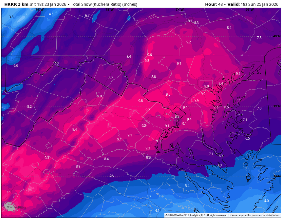
-
GSP disco is out. Man, they are really struggling with this one https://forecast.weather.gov/product.php?site=NWS&issuedby=GSP&product=AFD&format=CI&version=1&glossary=0&highlight=off
-

Possible Record Breaking Cold + Snow Sunday 1/25 - Tuesday 1/27
RU848789 replied to TriPol's topic in New York City Metro
I think everyone knows we have warnings up for everyone covered by the NWS-Philly and NYC offices. A summary is bulleted below, as I find wading through the full text to be tedious; the first 4 bullets are the counties under the NWS-Philly, while the last 2 are under NWS-NYC. One can argue that these numbers are a bit aggressive vs. other forecasters, but the NWS hasn't wavered, really, other than knocking down snowfall forecasts a bit south of 78 due to some sleet and adding in some ZR. There are also some models that show 10"+ amounts given good ratios (like 12-15:1), so it's not like the forecast is crazy, just higher than most; their latest map s arebelow. With temps below 20F for most and some wind, it'll be frigid and salt won't work as well, plus there will be some wind (20-25 mph) so some drifting is possible. For counties S of 276/195 in SEPA/SNJ/N DE, the warning is for 8-12" of snow/sleet plus about 0.3" of freezing rain (ZR) For Atlantic/Cape May counties and southern DE, the warning is for 6-10" of snow/sleet plus about 0.1" ZR For Sussex/Warren/Poconos/Lehigh Valley, the warning is for 12-18" of snow plus a light glaze of ZR For Morris-Hunterdon-Somerset-Middlesex-Monmouth-Mercer-Ocean-W Montco and Bucks, the warning is for 10-15" of snow/sleet, plus about 0.1" of ZR For W. Passaic, the entire Hudson Valley and the coastal CT counties, the warning is for 12-16" of snow For NENJ (Union/Essex/Hudson/Bergen/E Passaic), NYC and LI, the warning is for 10-14" snow/sleet plus a light glaze of ZR https://forecast.weather.gov/wwamap/wwatxtget.php?cwa=PHI&wwa=winter storm warning -

January 2026 regional war/obs/disco thread
codfishsnowman replied to Baroclinic Zone's topic in New England
I wasn't thinking quite as lofty as 20, moreso just widespread ten plus back to back but .....these big numbers being thrown out with the overrunning on steroids for later in the weekend seem slightly ambitious even with an inch of qpf widespread. I am old enough to have seen plenty of 10 to 1 snow in frigid temps. Remember the end of the party in 2/11 everyone except you Scott and a couple others reigning in the numbers with that overrunning event....Some places in central New England and northern Southern New England were forecasting up to 20 inches!! -

Possible Record Breaking Cold + Snow Sunday 1/25 - Tuesday 1/27
eduggs replied to TriPol's topic in New York City Metro
No noteworthy changes between the 18z and 12z HRRR through 41 hours outside typical noise. 850mb heights look a tiny bit flatter. -
That would give me something to do after surgery .