All Activity
- Past hour
-
UTC time takes some getting used to but memorize these #s. Daylight savings moves them forward one hour but during winter it looks like this: 0z = 7pm 6z = 1am 12z = 7am 18z = 1pm
-

1/24-1/25 Major Winter Storm - S. IL, IN, and OH
michsnowfreak replied to A-L-E-K's topic in Lakes/Ohio Valley
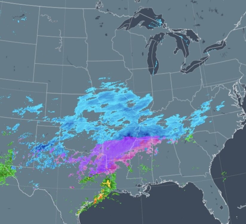
NWS issued a winter storm warning for monroe co for 5-8". Advisory for wayne for 4-6" isolated 7". Advisory for Oakland and macomb for 2-4" isolated 5" -

January 24-26: Miracle or Mirage JV/Banter Thread!
Kay replied to SnowenOutThere's topic in Mid Atlantic
Reached?? Armchair psychology is second only to weather tracking here haha. I'm still hoping for a 6" floor as I have been for days (yes, including sleet). I am in the Baltimore-North snow drought hole with Maestro, Towson, Rick, BaltoSquid etc and I wanted a bigger, snowier storm and get anyone who is bummed BUT I refuse to spend the storm all cranky. Not reading hundreds of cranky posts either, it will be ignore time and get off the forum time. Here's to frozen precip, health, happiness, and hopefully some laughs as it plays out! -
Weather forecasting has become an absolute joke. It’s 2026, and they often can’t even predict the low/high temperatures with any reasonable degree of accuracy. I’m not sure what has happened in the meteorological science field, but something is wayy off.
-

Jan 24-26 Weekend Snow and Sleetfest Model Thread Part Tres
Ralph Wiggum replied to H2O's topic in Mid Atlantic
Not sure that it means anything, but the freezing rain aspect is overperforming in the deep south -

Extreme Cold, Snow & Sleet: SECS 1/25 - 1/26
Winterweatherlover replied to TriPol's topic in New York City Metro
It's all a matter of perspective, the NAM likes the storm for central and northern NE a lot lol -
zulu (z) time is 5 hrs behind est during standard and 6 hrs behind during daylight savings
-

Jan 24-26 Weekend Snow and Sleetfest Model Thread Part Tres
baltosquid replied to H2O's topic in Mid Atlantic
Hmmm, however the UKMET is more aggressive with temps later and flirts with outright rain in the metros. I don't think that will happen at this point given pretty much everything else but probably means more of a FZR event in reality. -
 Hows it looking out your way guys. Is the cold and snow overperforming?
 -
 Dusting of snow near Crossville and has been snowing steady for an hour or two. I notice TDot must've added cameras at 304mm (near Monterey on Putnam/Cumberland line) and 333mm (near Crab Orchard) recently, which is helpful for travel conditions on the plateau.
 -

Jan 24-26 Weekend Snow and Sleetfest Model Thread Part Tres
Terpeast replied to H2O's topic in Mid Atlantic
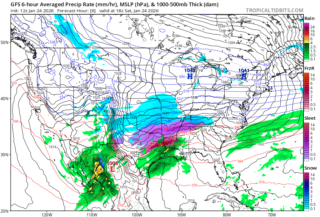
Comparing gfs forecast for 18z today with current radar Seems faster? Sleet line a bit south
-

Jan 24-26 Weekend Snow and Sleetfest Model Thread Part Tres
alexj7 replied to H2O's topic in Mid Atlantic
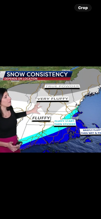
Every 6 hours I check back in and the mixing is earlier and earlier. I’m seeing now around 9 AM. Unfortunately, that will really limit the ability for people to enjoy the storm. We’ll have kids home for likely two days stuck inside, and going out in sleet and freezing rain isn’t a good time. I’d much rather be on the northern fringe and get 4” of powder. -

Jan 24-26 Weekend Snow and Sleetfest Model Thread Part Tres
mitchnick replied to H2O's topic in Mid Atlantic
.thumb.png.6ee49da7de8c9e6f113e5ed521ab6ad4.png)
-

January 25/26 Jimbo Back Surgery Storm
Brick Tamland replied to Jimbo!'s topic in Southeastern States
HRRR -

Central PA Winter 25/26 Discussion and Obs
WmsptWx replied to MAG5035's topic in Upstate New York/Pennsylvania
It me. (Probably not. Probably Coudersport lol). -

E PA/NJ/DE Winter 2025-26 Obs/Discussion
MJO812 replied to LVblizzard's topic in Philadelphia Region
Op gfs is closer -

January 25/26 Jimbo Back Surgery Storm
Leesville Wx Hawk replied to Jimbo!'s topic in Southeastern States
It’s not over yet but the trend continues to be less of a prolonged ZR situation. Looks also like there won’t be much snow/sleet accumulation in the Triangle region. . -
I've been keeping my eye on that. It appears we get a little Coastal enhancement once it rounds the base.
-

1/24-1/25 Major Winter Storm - S. IL, IN, and OH
ILSNOW replied to A-L-E-K's topic in Lakes/Ohio Valley
for chicago peeps from Milwaukee NWS Confidence is increasing that a lake effect snow band will come onshore early Sunday morning into Sunday afternoon. If the snow band comes ashore, moderate to heavy rates are possible from Milwaukee southward. Alek is going to clean up -

Extreme Cold, Snow & Sleet: SECS 1/25 - 1/26
SACRUS replied to TriPol's topic in New York City Metro
1/24 12z GEFS Total QPF Total snow /sleet (10:1) -
I pray this storm is a bust, and that the public is mad because they didn't lose power for a week and people didn't die because of no heat.
-

“Cory’s in LA! Let’s MECS!” Jan. 24-26 Disco
Damage In Tolland replied to TheSnowman's topic in New England
-

Extreme Cold, Snow & Sleet: SECS 1/25 - 1/26
North and West replied to TriPol's topic in New York City Metro
It’s not the storm it hates, it’s us. . -

Central PA Winter 25/26 Discussion and Obs
Mount Joy Snowman replied to MAG5035's topic in Upstate New York/Pennsylvania
The Ukie holds with 10+ for the forum but to be honest I think it's struggling with the sleet depiction and underdoing it a bit, unfortunately. Has a decent primary into western PA and displays a weird orientation of the sleet axis. But I would be thrilled with its result at this point. -

“Cory’s in LA! Let’s MECS!” Jan. 24-26 Disco
moneypitmike replied to TheSnowman's topic in New England
If I really squint, i can see a tinge of pink on mi casa on the GFS qpf map. keep nudging.


.png.2b562ed19da2e67e4cfae509e9e57ae4.png)


