All Activity
- Past hour
-
It’s definitely warmer than modeled. But this is stale cold. The cold should start to dump in after 4pm. Enjoy the warmer temps while you can lol
-

Possible Record Breaking Cold + Snow Sunday 1/25 - Tuesday 1/27
SI Mailman replied to TriPol's topic in New York City Metro
I’m being conservative and going 6 to 10 for my backyard. I’ll bump it up if the sleet line keeps shifting south -
Pitching from the windup
-

1/24-1/25 Major Winter Storm - S. IL, IN, and OH
Stevo6899 replied to A-L-E-K's topic in Lakes/Ohio Valley
Can you please update this to show since 2000. -
Regarding the comments about S shore jacks by Marshfield etc...got to watch temps there. It may tick above 32 there for 3-5 hrs Monday morning....even perhaps close to here. Just something to keep in mind. We lose the deeper lift too so you'll need more OE assist.
-

Jan 24-26 Weekend Snow and Sleetfest Model Thread Part Tres
Maestrobjwa replied to H2O's topic in Mid Atlantic
What a crazy stretch of winter we seem to be heading into! And I never remember having a warning-level snow followed by an Arctic plunge like this. True deep winter stuff indeed! -

1/24-1/25 Major Winter Storm - S. IL, IN, and OH
sbnwx85 replied to A-L-E-K's topic in Lakes/Ohio Valley
Catching up this morning — too bad most guidance showing the drying trend on the north side of this system. Hopefully ratios make up for lack of QPF but 3” of system snow seems like a lock here. We’ll see what the lake can deliver on Monday. -

January 24-26: Miracle or Mirage JV/Banter Thread!
Shane M. replied to SnowenOutThere's topic in Mid Atlantic
You could create an account on the COMET ucar website and take a look at this: https://learn.meted.ucar.edu/#/online-courses/43c003e8-0c3d-4cba-bfa0-467845c88b40 -

January 25-26 Winter Storm Potential
The Iceman replied to Ralph Wiggum's topic in Philadelphia Region
Yeah I came of age in the warmer years, it’s always been this sleet crap for me -

“Cory’s in LA! Let’s MECS!” Jan. 24-26 Disco
Damage In Tolland replied to TheSnowman's topic in New England
Please no subtle undertones -
48 now. Where the fuck is this cold air?
-
FYI - Goodman, Kasper and DT will be special guests tonight on The Joe and Joe Weather Show at 7:30 on You Tube.
-

Central PA Winter 25/26 Discussion and Obs
Mount Joy Snowman replied to MAG5035's topic in Upstate New York/Pennsylvania
Almost forgot: RRFS - Sleet barely enters Y/L late afternoon but is beaten back, 12-15" totals. Tonight and tomorrow's runs will be very telling with regard to any warm air intrusion between 850 and 700mb, but I am liking the general trends and leaning towards the colder solutions winning out. -
Moneypitmike may break something because PWM is getting 1.5" more then him.............
-

January 25-26 Winter Storm Potential
Birds~69 replied to Ralph Wiggum's topic in Philadelphia Region
I know what you're talking about. I78 was never mentioned years back...Iceman is a younger lad. -

“Cory’s in LA! Let’s MECS!” Jan. 24-26 Disco
bristolri_wx replied to TheSnowman's topic in New England
What a sneaky bugger that warm nose at around 800mb! Still snow, but mutha-fooka...

-

Jan 24-26 Weekend Snow and Sleetfest Model Thread Part Tres
pazzo83 replied to H2O's topic in Mid Atlantic
Got down to -21F at MSP, and O'Hare -11F. Cold. -

Jan 24-26 Weekend Snow and Sleetfest Model Thread Part Tres
clskinsfan replied to H2O's topic in Mid Atlantic
Euro is below freezing until February 7th when it finally hits 35 degrees. -
January 24-26: Miracle or Mirage JV/Banter Thread!
Maestrobjwa replied to SnowenOutThere's topic in Mid Atlantic
Well that's funny...3 other people in here responded graciously and it's not started a convo and sharing of information. And all you had to do is share the links, not with the passive-aggressive "Was that so hard??" thing. Totally unecessary. Nah--you just naturally go at people like that. Adults ask other adults about crap they don't know. And lo and behold...and H5 video that demonstrated what I was talking about I did not find. -

Possible Record Breaking Cold + Snow Sunday 1/25 - Tuesday 1/27
wthrmn654 replied to TriPol's topic in New York City Metro
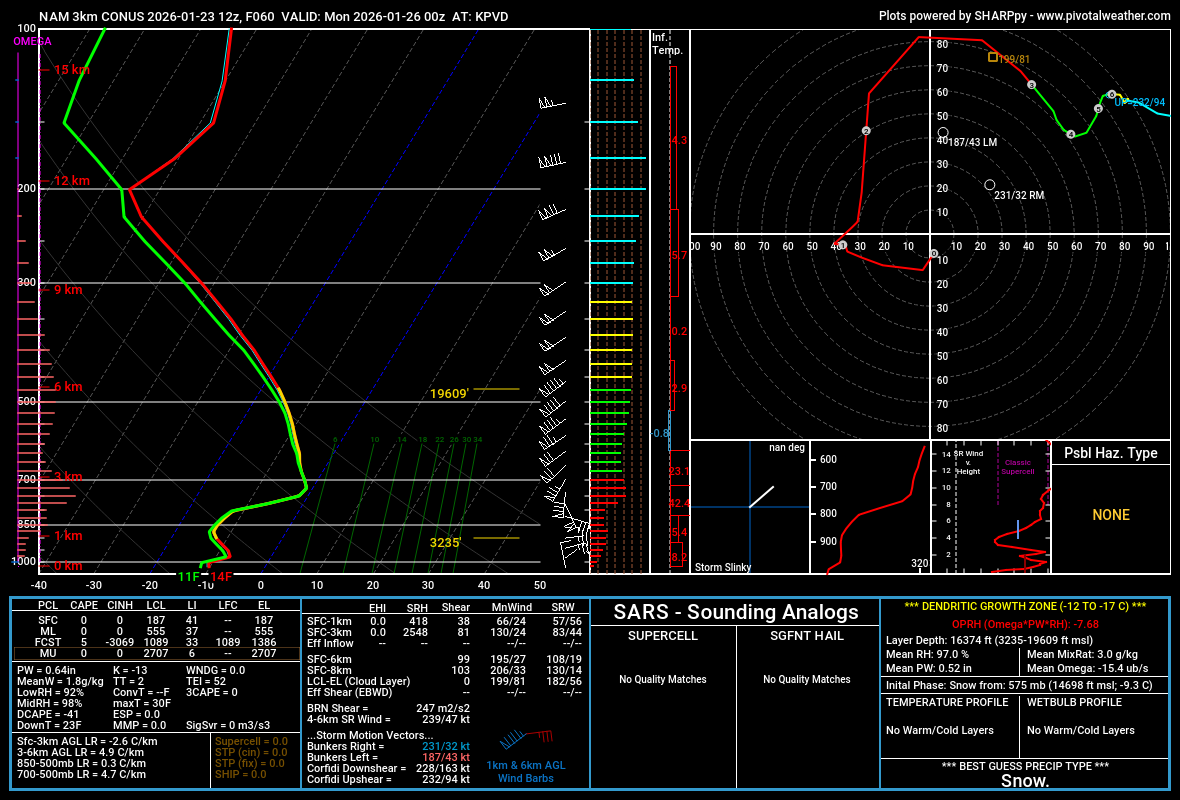
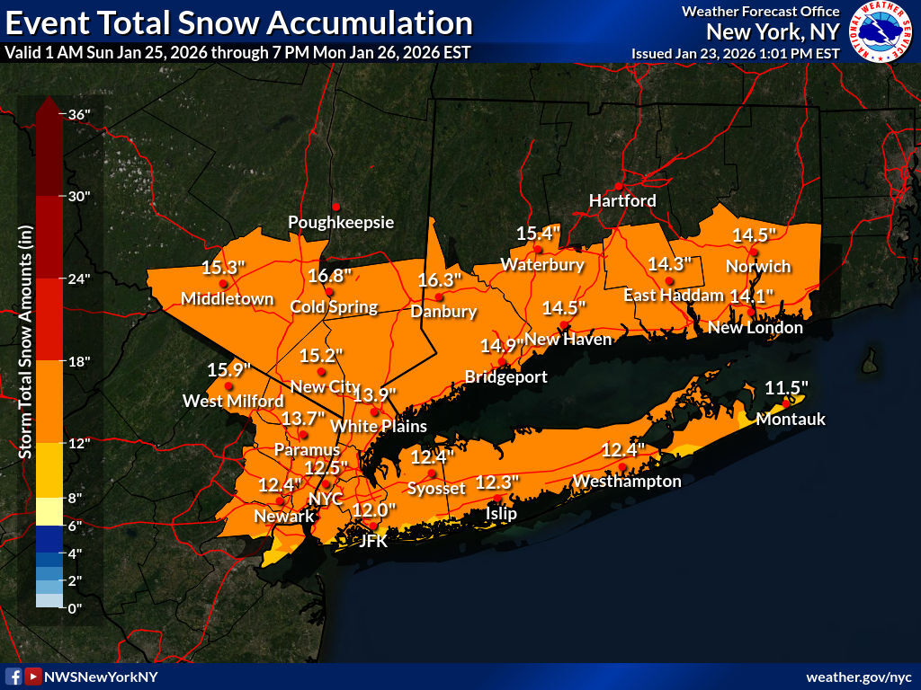
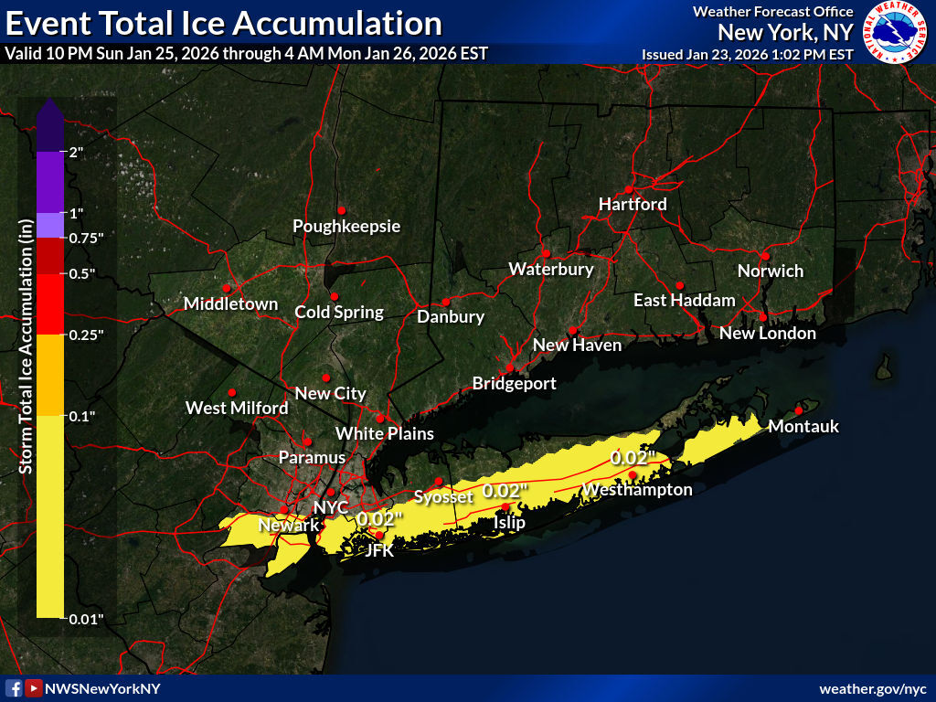
Latest snowfall forecast updated below, along with upgrades to winter storm warnings for the entire area from early Sunday through much of Monday. Totals have increased a bit across the interior and decreased slightly southeast portions of the area. We've also introduced some light ice accumulation for LI and southern parts of NYC for the potential mixing late Sunday/early Monday. Full briefing out in a bit. For those looking for weather information adjacent to our area of coverage, check out the latest winter weather forecasts from our colleagues at Boston/Norton, Philadelphia/Mt Holly, Albany, and Binghamton.

-

Pittsburgh/Western PA WINTER ‘25/‘26
RitualOfTheTrout replied to Burghblizz's topic in Upstate New York/Pennsylvania
Keep em coming! -

Possible Record Breaking Cold + Snow Sunday 1/25 - Tuesday 1/27
weatherpruf replied to TriPol's topic in New York City Metro
at least we don't have the dreaded coastal flood watch....usually indicating a flip to rains.... -
I caught a reference to this in the cle discussion The past several model cycles have seen a NW shift in the track of the surface low and resultant axis of heaviest snowfall, and there is still time for further refinements to the track as model guidance resolves the aforementioned phasing. Northern and southern stream jet phasing is known to pull systems farther NW than models initially indicate, so this NW trend has not been surprising
-

Texas 2026 Discussion/Observations
aggiegeog replied to Stx_Thunder's topic in Central/Western States
Ice storm warning now for East Texas along and south of I-20. I still think I have a chance to get lucky and be more on the sleet side but its cutting it real close. -

January 2026 regional war/obs/disco thread
CoastalWx replied to Baroclinic Zone's topic in New England
Euro suite says we need to move that trough axis more west.