All Activity
- Past hour
-
Hm...perhaps the stj waking up could help with that?
-
Unclear if the 25th is the big one or 29th, or both. But 25th can hit followed by an Archabault near the 29th as the NAO briefly flips positive. Loving the loaded pattern. Sometimes the last in succession when a tellie flips is the one we do the this hobby for, so we'll see.
-
Has anything really changed though? We still lack an established cold high. We're still relying on cold air chasing moisture. I guess higher qpf allows more dynamic cooling?
-
GGEM waves hello
-

First Legit Storm Potential of the Season Upon Us
WxWatcher007 replied to 40/70 Benchmark's topic in New England
Really only get one shot at this given how close we are to onset. Folks won’t pay attention to numerous evolving maps imo. Makes sense to take the time to get it right. -

Storm potential January 17th-18th
Stormlover74 replied to WeatherGeek2025's topic in New York City Metro
Fwiw ukie is pretty light for tomorrow. Just an inch or two outside eastern LI -
I could see another 1" - 3" for Carroll, northern Baltimore/Harford/Cecil tomorrow.
-

E PA/NJ/DE Winter 2025-26 Obs/Discussion
MGorse replied to LVblizzard's topic in Philadelphia Region
Impressive! -

Storm potential January 17th-18th
SnowGoose69 replied to WeatherGeek2025's topic in New York City Metro
Yeah, no high to the north as I said. I don't really love this setup but I do think that the air mass might be just cold enough that we get accumulation. I'd just go lower than snow maps though. I don't think anyone is seeing 5 or 6 inches. -

Storm potential January 17th-18th
NorthShoreWx replied to WeatherGeek2025's topic in New York City Metro
Nice day here. 42⁰ It looked for a while like the sun might peak through the clouds. -
GFS says surface temps here are 12 degrees when the precip begins. Then 1.5" of QPF falls before temps rise above 20 degrees. Acceptable.
-

Storm potential January 17th-18th
winterwarlock replied to WeatherGeek2025's topic in New York City Metro
Yep giant flakes. The last half hour 1/2 inch -

Central PA Winter 25/26 Discussion and Obs
WmsptWx replied to MAG5035's topic in Upstate New York/Pennsylvania
I will take that -

Central PA Winter 25/26 Discussion and Obs
canderson replied to MAG5035's topic in Upstate New York/Pennsylvania
That’s crazy the diff between you and I. Congrats! And safe travels. -

Storm potential January 17th-18th
BoulderWX replied to WeatherGeek2025's topic in New York City Metro
Definitely over 2” and still under heavy returns for what looks like the next hour. 3” is looking likely. And maybe a couple inches tomorrow. Great winter weekend. -

Storm potential January 17th-18th
SnoSki14 replied to WeatherGeek2025's topic in New York City Metro
Heavy stuff right now. Very strong thermal gradient driving these rates. -
How much is from today?
-
Wantage NJ 8 s High Point: 1135AM 1/2 per hr rates continue. Now at 2.8 for the day. Beautiful straight down snow... everything covered. 27.7F
-
GFS is likely too amped with the storm idea. I am more worried about suppression problems overall than being too far north
-
At least you have precip. The ridiculous drought continues here.
-
1.5" now on the hill.
-

First Legit Storm Potential of the Season Upon Us
The 4 Seasons replied to 40/70 Benchmark's topic in New England
prob waiting to digest full 12z suite and coordinate with other offices on WSWs (WSW is watch/warning/adv) before making wholesale changes. that would be my guess. -
Yup. You were right. Was trying to get shit out and while sv maps showed us below 0 on junk maps, soundings had that warm layer in.
-

E PA/NJ/DE Winter 2025-26 Obs/Discussion
blackhound replied to LVblizzard's topic in Philadelphia Region
Glen Mills, Middletown Township. 32.6F/DP 30.0F. Hearing pingers on the skylights intermittently. Cars are topped and driveway barely covered with an icy snow mix of a scant 1/2 inch but intensity has picked up dramatically as well as the flake size. -
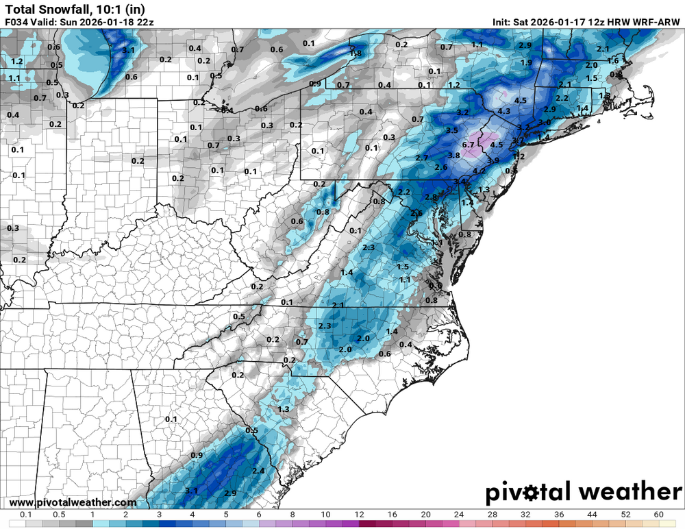
WRF-ARW on board as well for tomorrow