All Activity
- Past hour
-
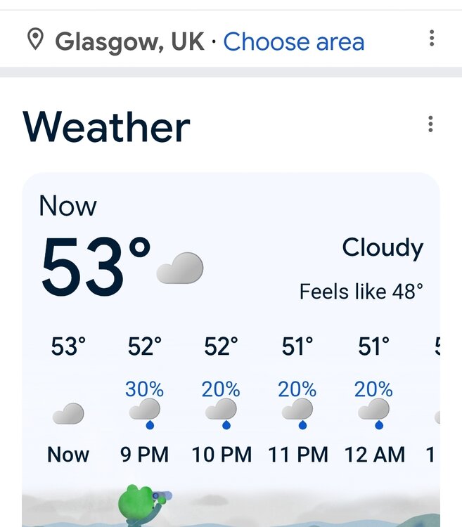
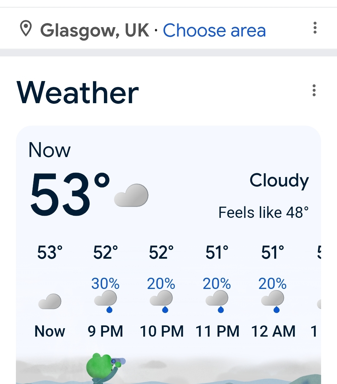
I do not get these impressive temp where my weather station is located... but where I lack in temp, I make up in DP. 88.9/76.9 FL 101.5
-
It was quick... .12
-
It seems like ever since 2018 the hottest weather of the season is in June. Severe thunderstorm watch
-
Definitely agree. Maybe not so far north in Illinois into West and Southern Cook county, maybe South Eastern Cook?, but the rest is spot on to me. Skilling was back on WGN yesterday mentioning the lakes influence for more intense and long trek tornadoes in northern Indiana.
-
96/73
-

2026 Mid-Atlantic Severe Storm General Discussion
SnowenOutThere replied to Kmlwx's topic in Mid Atlantic
Noticing a tall CU cloud shooting up near Dulles. Seems to have hit the LFC and keeps rising.- 599 replies
-
- 1
-

-
- severe
- thunderstorms
- (and 7 more)
-
Didn't realize this thread was here. I've been over the main Enso thread fighting the warmanistas with no help from @Stormchaserchuck1. Honestly, the Cfs2 does have historic potential written all over it for February and March. Coincidentally, latest 500mb runs for December looked similar at times to Euro seasonal fwiw.
-
old outdated roads with too few lanes/turning lanes sucks
-
Finally made it. Traffic sucks. Hate driving anymore
-
Ended up having a supercell quickly develop over DuPage County last evening, which then moved through ORD. There was a transient wall cloud at times with it as it approached from the southwest, as the storm interacted with an OFB and briefly tried to be interesting.
-
holy shit DCA hit 100F.
-
Blessed really
-
Imagine the sunburns. These folks have probably never seen the Sun.
-
this is going to be another "pop up" storm day radars showing activity east of Allentown and other areas widespread through the region
-
I'm kinda bustin balls. Truth be told, not sure what the convective temp/sequencing is. We may just need another hour of heating, which can happen at this time of year until 5:30 really. I tell you what, on a separate note high heat a day after severe convection anywhere around here is definitely a Gretta effect -
-
Another year where the hottest weather will be in June
-
yeah not sure what we get today after being hammered yesterday but that area is a bit west and missed out yesterday so maybe they get it today?
-
Eyeing next weds for a severe threat here in IL/IN/OH, longwave trough moving into the region, should be a great shear profile. funnily enough, biggest question IMO is how far east the best instability makes it.
-
boring and hot nothingness chasing ? ooh, make sure to get some videos
-
Severe Watch Issued For Metro WWUS from KWNS WOUS from KWNS
-
Again ... Brian's sarcasm is well placed and probably needed as a dose of reality, but I contend that the image of the pattern as a skewing force. The constant bombardment of model engagement is tinting perceptions perhaps. As I've been pointing out, there's a bit of a disconnect that's been evolving over particularly the last 20 years, where the pattern and the temperature results seem unmatched. Take next week on the GFSX machine. All SNE sites, BDL-MHT, are between 81 and 84. That's climo resulting from a pattern that looks below normal. Add to that, as we get out to D3..4, those numbers get increasingly weighted by climatology, so... any 84 next Thursday could very well actually be upper 80s... Now we're talking above normal in a below normal looking pattern. But people are only remembering the pattern at the end of the months. This is how perception divorces reality - or at least one way in which the observer is kind of manipulated.
-
URGENT - IMMEDIATE BROADCAST REQUESTED Severe Thunderstorm Watch Number 321 NWS Storm Prediction Center Norman OK 245 PM EDT Fri Jun 12 2026 The NWS Storm Prediction Center has issued a * Severe Thunderstorm Watch for portions of District Of Columbia Maryland Virginia Eastern West Virginia Coastal Waters * Effective this Friday afternoon and evening from 245 PM until 900 PM EDT. * Primary threats include... Scattered damaging wind gusts to 70 mph likely Isolated large hail events to 1 inch in diameter possible SUMMARY...Clusters of storms will form in Virginia and Maryland this afternoon, and will spread eastward from West Virginia. The storm environment will favor damaging downbursts with winds up to 60-70 mph, while the strongest storms could produce isolated large hail near 1 inch in diameter.
-
Yeah, I hear ya. Fact of the matter is...we also have not yet to experienced a synergistic/resonant feed-back heat scenario in this region of continent. They're actually studied in climate as "synergistic heat waves" world over. I may be that we can't. We might just have too many goephysical traits that make that less able to happen here, but like western Europe and Australia, the steppe of the Urals and over in Russia ... Chinese Asia... The Pacific NW in 2020 is an example of that, where carried on for 10 days at some 35+ for high temps.
-
Last night was weird - the gust front produced winds of at least 50-55 mph and put numerous branches down all over the yard, including a few big ones, and snapped one of my potted plants. Then it did not rain a drop
-

Junorch obs and discussion 2026
Damage In Tolland replied to Damage In Tolland's topic in New England
It seems there’s only one person frustrated and that person will have some of the hottest temps next week with West flow DSD


.thumb.jpg.ad3a2e31d30aff035044689b311a0540.jpg)

