All Activity
- Past hour
-

2026 Mid-Atlantic Severe Storm General Discussion
Eskimo Joe replied to Kmlwx's topic in Mid Atlantic
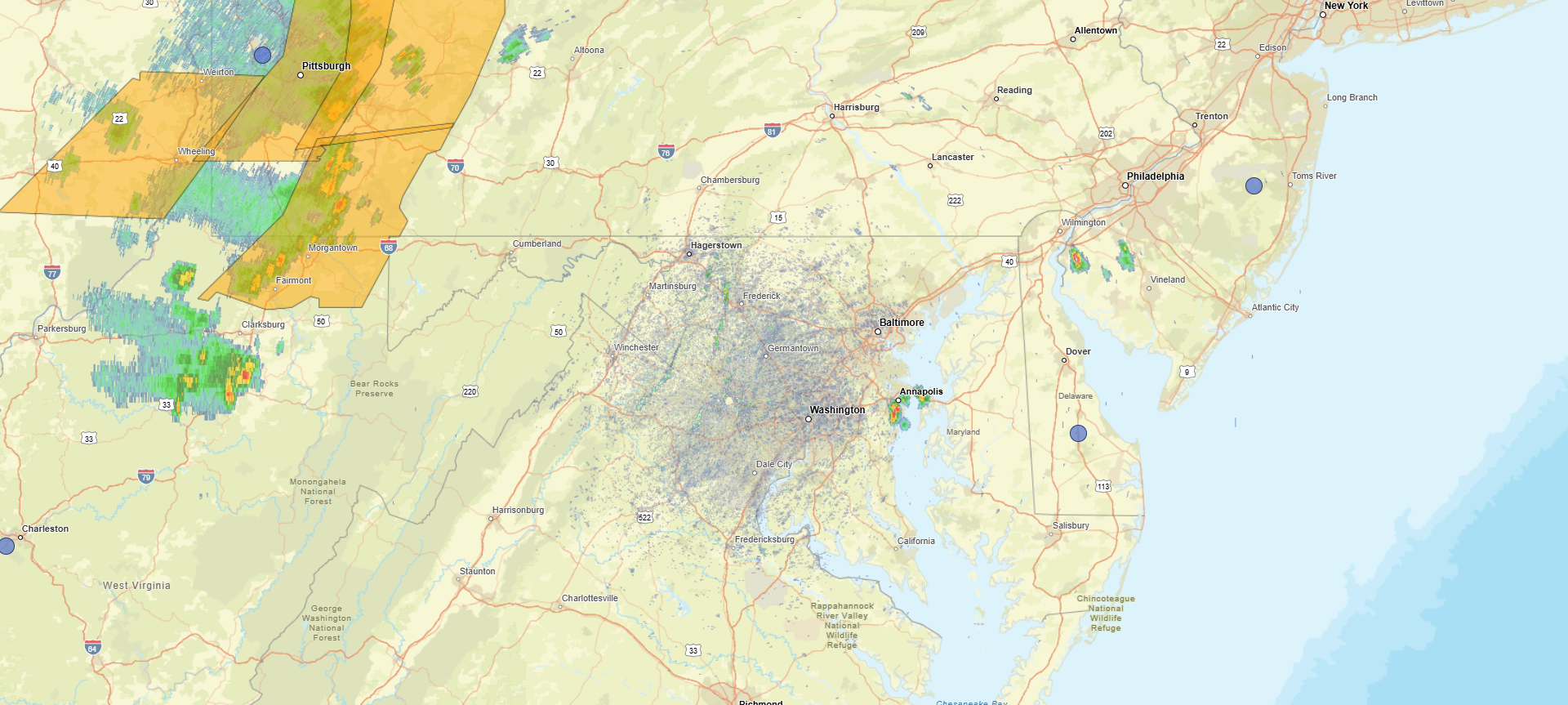
Pretty incredible storms near Pittsburgh. Radar showing 60-65kt winds about 1,000 foot off the surface just north of the city. -
Several cells popping up already.

-

Junorch obs and discussion 2026
Damage In Tolland replied to Damage In Tolland's topic in New England
Models have virtually nothing tomorrow -
97 for a high so far. They “benefitted” from getting very little rain yesterday.
-
Yep
-
actually these don't appear that impressive. there's not much shear organization. More pulse variety.
-
Pittsburgh PA Summer 2026 Thread
Eskimo Joe replied to TheClimateChanger's topic in Upstate New York/Pennsylvania
Looks like they lost power in the terminal. -
It sucks out there for sure. I am staying in the house.
-
Cheshire Village area down there
-
Pittsburgh PA Summer 2026 Thread
Eskimo Joe replied to TheClimateChanger's topic in Upstate New York/Pennsylvania
Very impressive velocity signatures across Allegheny County. 911 centers probably pretty busy right now. That second line coming through Ohio is getting beefier. -
90/75, HI 99
-
94 with heat index of 108
-
sangamon county is in the watch. springfield can't be in the watch if sangamon county isn't.
-
Junorch obs and discussion 2026
Damage In Tolland replied to Damage In Tolland's topic in New England
Wiz should head to Meriden -
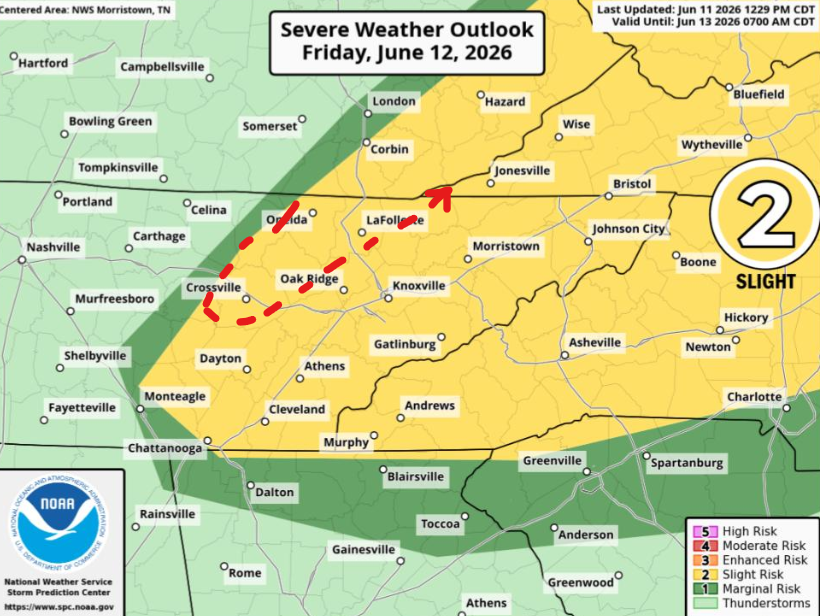
Friday is kind of Slight or nothing with that CAPE. Where it goes it'll go fast. Only reason for a marginal is placement of initiation; otherwise, should go from shower to severe quickly. Wind will be the main threat though. MRX has some concern about a boundary draped across the region. Winds will mostly be veered off which keeps the threat straight. However any boundary cooking in June can do things right where the SRH is locally higher. Then if the boundary is on the Upper Plateau, we know what can happen. While SPC omits 2% MRX leaves the door cracked. (AFD not map) Red line is mine. Keep it broad north of Tenn. I'm less familiar with the terrain.
-
In the last 10 min we broke 100 at my house and peaked at 100.1 currently fluctuating between 99.4 and 99.9. First 100 reading of the year and I fear it won’t be the last
-

Pittsburgh PA Summer 2026 Thread
Mailman replied to TheClimateChanger's topic in Upstate New York/Pennsylvania
53mph at the airport, I see. -
True ...I haven't heard any news breaking out of that area tho so it might not have resulted as awesome as that scabby bowed radar looked. These rad products...I swear they're getting goosed for marketing click bate. That thing's rad Rembrandt looked like an atmospheric tsunamis of hail, rain ... leaves and roofing shingles on the leading edge of a-bomb p-wave.
-

2026 Mid-Atlantic Severe Storm General Discussion
midatlanticweather replied to Kmlwx's topic in Mid Atlantic
Mesoscale Discussion 1091 NWS Storm Prediction Center Norman OK 0202 PM CDT Thu Jun 11 2026 Areas affected...the Mid-Atlantic into southern New York and southwestern New England Concerning...Severe potential...Watch possible Valid 111902Z - 112100Z Probability of Watch Issuance...40 percent SUMMARY...Scattered thunderstorm development is expected this afternoon across the mid-Atlantic northward into southern New York and southwestern New England. Severe wind gusts and hail are possible with the strongest storms. DISCUSSION...Some deeper convective attempts are underway this afternoon across portions of the mid-Atlantic, particularly in southern New York as of 1900z. This development is occurring in a warm, unstable airmass with surface temperatures in the upper 80s and lower 90s F and MLCAPE values around 2000+ J/kg. The 18z ALB/Albany, NY sounding sampled the northern periphery of this airmass (along the CAPE gradient) with 0-6-km shear of 24 kts. This has supported some sporadic, more organized thunderstorm development recently. As the afternoon progresses, diurnal heating should support additional thunderstorm development across the region. Furthermore, a mid-level impulse in eastern OH -- influencing the ongoing convection in WW312 -- will continue moving eastward and should provide additional support for convective initiation and maturation. Bulk shear is expected to remain generally in the 15-25 kt range which, amidst forecast large MLCAPE around 2500-3000 J/kg, will promote strong updrafts capable of producing wind gusts and hail. Uncertainty remains as to how much convection will develop and coalesce/strengthen in the short term, but trends will continue to be monitored for possible watch issuance this afternoon. ..Flournoy/Gleason.. 06/11/2026 ...Please see www.spc.noaa.gov for graphic product... ATTN...WFO...OKX...ALY...PHI...BGM...AKQ...CTP...LWX... LAT...LON 39937855 42097738 42657579 42777436 42337326 41237290 40177310 37717495 37397648 37777765 38937842 39937855 MOST PROBABLE PEAK WIND GUST...55-70 MPH MOST PROBABLE PEAK HAIL SIZE...1.00-1.75 IN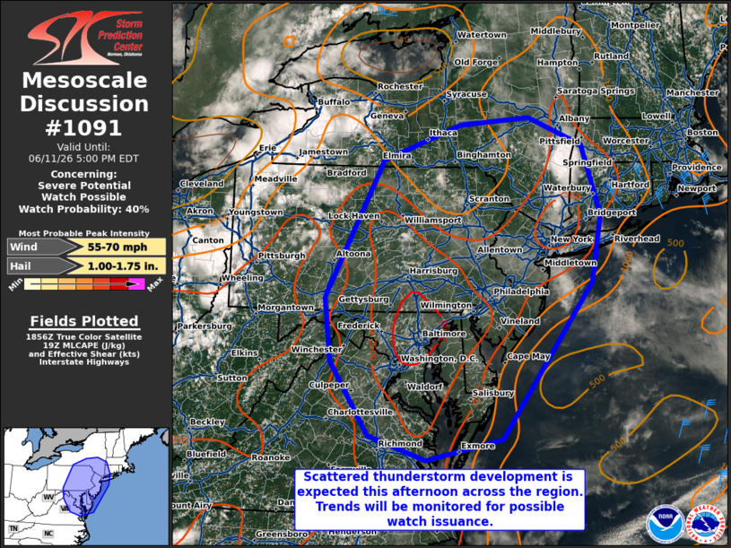
- 492 replies
-
- 1
-

-
- severe
- thunderstorms
- (and 7 more)
-

E PA/NJ/DE Summer 2026 Obs/Discussion
JTA66 replied to PhiEaglesfan712's topic in Philadelphia Region
93F/DP 76F -
Pittsburgh PA Summer 2026 Thread
Mailman replied to TheClimateChanger's topic in Upstate New York/Pennsylvania
No action to report in the metro? -
It’s amazing how well Iowa does derecho
-
Junorch obs and discussion 2026
Damage In Tolland replied to Damage In Tolland's topic in New England
Yes I’ve been thinking Steiner here today and tomorrow. This is a west of 91 deal. It was this areas turn to Stein this summer after getting so much rain last summer while others missed .35 MTD -
looks like my high's 91 ... but with 72 DP it's definitely the highest HI of summer so far. We did get that 97 F day back in the heat wave early in May, but the DP in that was like 53 or something parched.
-
Good call on including Springfield in the watch even though none of Sangamon County falls within the watch box. (Same with Morgan and Scott counties as well). Especially after what happened on the north side of the city and in eastern Sangamon County last night. It was probably going to eventually get locally extended here too so might as well get it out of the way. But interesting how the rest of the counties where I-72 goes through--all containing big population centers--were omitted for now barring a later local extension--even though the south edges of the watch box were closer to those counties than Sangamon? (Macon--Decatur; Piatt--Monticello; and Champaign--C/U--plus although 72 ends at C/U you have Danville and Vermilion county excluded from the watch at this time. Unless SPC in cooperation with ILX is seeing something that I'm not?