All Activity
- Past hour
-
 As always one of the best products to watch as an event is ongoing (besides radar)
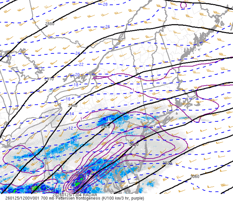
-
Probably warming aloft from the primary low to your west. Once the coastal gets going and tracks inside the benchmark, I'll be fucked lol.
-

January 25-26 Winter Storm Potential
RU848789 replied to Ralph Wiggum's topic in Philadelphia Region
As of 8:00 am 2.6" otg at 11F, so 0.6" the last 30 min - can't imagine not making it to at least 8" with at least 5 hours of >1"/hr rates before any changeover (and hopefully the changeover is after that and rates are more than 1" per hour until then). Started around 5 am. -

Central PA Winter 25/26 Discussion and Obs
Mount Joy Snowman replied to MAG5035's topic in Upstate New York/Pennsylvania
Good morning everyone! 8am Obs: sitting at 10/8 with moderate to heavy snow and 3.7" accumulation. Real heavy stuff on the doorstep. These next several hours are the business down here because honestly I don't like the sleet trends at all from overnight. I think most of our afternoon is going to end up being squandered with pingers down here and it looks like it may in fact extend well into dauphin/lebanon counties. Even the models that were keeping the sleet totally at bay now bring it up this way. IN any case, big front-end thump looks glorious. Let's all enjoy this sweet powder. Good luck to all! -

January 25-26 Winter Storm Potential
BlueDXer75 replied to Ralph Wiggum's topic in Philadelphia Region
Great news! Eyeballing about 3-4 inches OTG in Spring Twp -
 I found a 60 near Townsend:
 -

January 25-26 Winter Storm Potential
Fields27 replied to Ralph Wiggum's topic in Philadelphia Region
Hopefully those rates can slow down that warm nose. That mix line is knocking on Baltimores' door and racing N. Sent from my SM-S938U using Tapatalk -
I do have an older phone actually. Switched my gf to my phone plan so she got a new phone and gave me her older one. I just have to finish setting it up. Will be great for storm chasing because I can have one phone for radar and one for recording.
-
Extreme Cold, Snow & Sleet: SECS 1/24 - 1/26
RU848789 replied to TriPol's topic in New York City Metro
As of 8:00 am 2.6" otg at 11F, so 0.6" the last 30 min - can't imagine not making it to at least 8" with at least 5 hours of >1"/hr rates before any changeover (and hopefully the changeover is after that and rates are more than 1" per hour until then). -
Aleet! It’s sleet. And it’s better than rain in Georgetown.
-
First flakes here at around 4:30 am. One inch by 6 am, at 11 F. 2 1/2" here at 8 am. With a good one inch per hour rate presently. 13 F. Fine "cold" looking flakes, a very wintry look, Coldest snowfall here since PD II, February of 2003!
-

Extreme Cold, Snow & Sleet: SECS 1/24 - 1/26
CPcantmeasuresnow replied to TriPol's topic in New York City Metro
5.9 degrees with heavy snow. A phrase more commonly heard from somewhere in the Adirondacks. -
Heavy band moving through now with big flakes- might be about to mix with sleet. Still 15
-

Historic Tennessee Valley Cold, Snow, and Ice Events
Jed33 replied to Carvers Gap's topic in Tennessee Valley
I saw this on FB this morning and thought I’d post it here. This article is about Morristown in general, but it sounds like it was quite the snowstorm for E TN. I didn’t live here then, but I know that was some kind of winter for sure, even in N MS where I was at the time.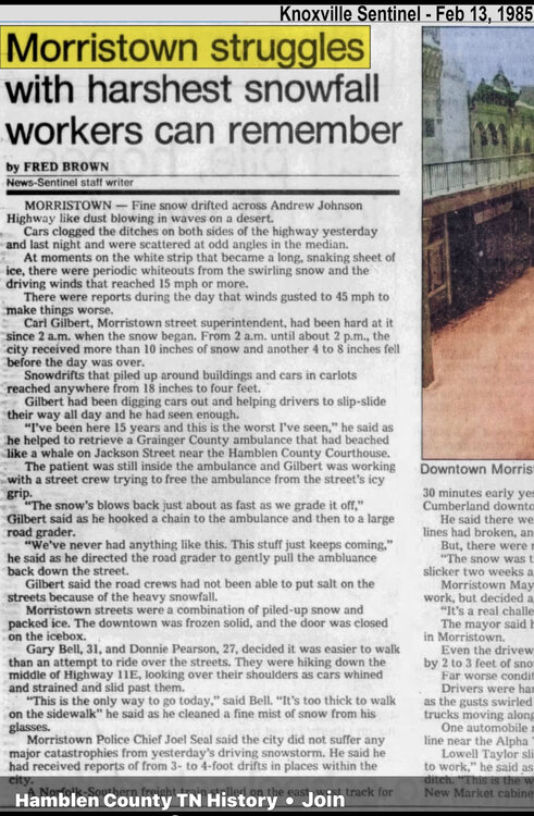
-

Southern Crippler - Get well soon Jimbo Storm Obs
Coach McGuirk replied to BooneWX's topic in Southeastern States
Well. I guess this is an ice storm. lol -
(002).thumb.png.6e3d9d46bca5fe41aab7a74871dd8af8.png)
January 25-26 Winter Storm Potential
ChescoWx replied to Ralph Wiggum's topic in Philadelphia Region
3.3" as of 8am here in EN temp down to 8.7 above -
I grew up in EC. Really miss that place for snow. Excellent location on that little hill.
-
4.2" at IAD, 4.1" at BWI, and 3.3" at DCA as of 7am
-
 mod snow now, looks like nws pegged from RT 44/6 north with 20+, and there is thunder snow in the deep south, hopefully get to see that later, always a treat, not like catore elevations of estaticism but awesome nonetheless
 -

January 24-26: Miracle or Mirage OBS Thread!
EastCoast NPZ replied to Jebman's topic in Mid Atlantic
Lol. How are you snowing still and ive been sleet more than an hour. -
Gaithersburg 5.5" of snow, SN+ right now. No sleet. Some mix between rimed snow and regular snow. We'll definitely get above 6, may even reach for 7-8 depending on how long that sleet can be held at bay.
-
 Will be flirting with sleet penetration here towards the tail end 10pm-1am.
 -
One place I've been wondering about is one of the few wunderground weather stations in the New River Valley in the Cumberland mountains about half way between me and John I was thinking they might hold on to cold air for a long time, but nope:
-

2025-2026 Fall/Winter Mountain Thread
Maggie Valley Steve replied to Buckethead's topic in Southeastern States
47 with light rain. I dodged a bullet and never lost power overnight. -
 Steady snow coming down, 7f.


