All Activity
- Past hour
-

Junorch obs and discussion 2026
CT Valley Snowman replied to Damage In Tolland's topic in New England
Another complex of storms to the SW. The rich get richer. -
Are you allowed to write about globar warning again?
-
There was a CC drop right over Calumet City a few min ago on that tor warned storm
-
93 today.
-

Winter 2026-2027 Seasonal Outlook
Upstate Tiger replied to WinstonSalemArlington's topic in Southeastern States
So we have officially entered El Niño phase. Most agree it will be strong and possibly super El Niño. The strongest El Niño on record was the super El Niño of 1877/1878. It actually started in late 1876 and was fully established in spring 1877. The winter of 1877/1878 was known as the year without winter, especially in the Midwest and eastern US. Farmers actually planted in February. This El Niño is starting a little later and no two are the same but at this point, an above average temp winter would be a good bet. -

2026 Mid-Atlantic Severe Storm General Discussion
SnowenOutThere replied to Kmlwx's topic in Mid Atlantic
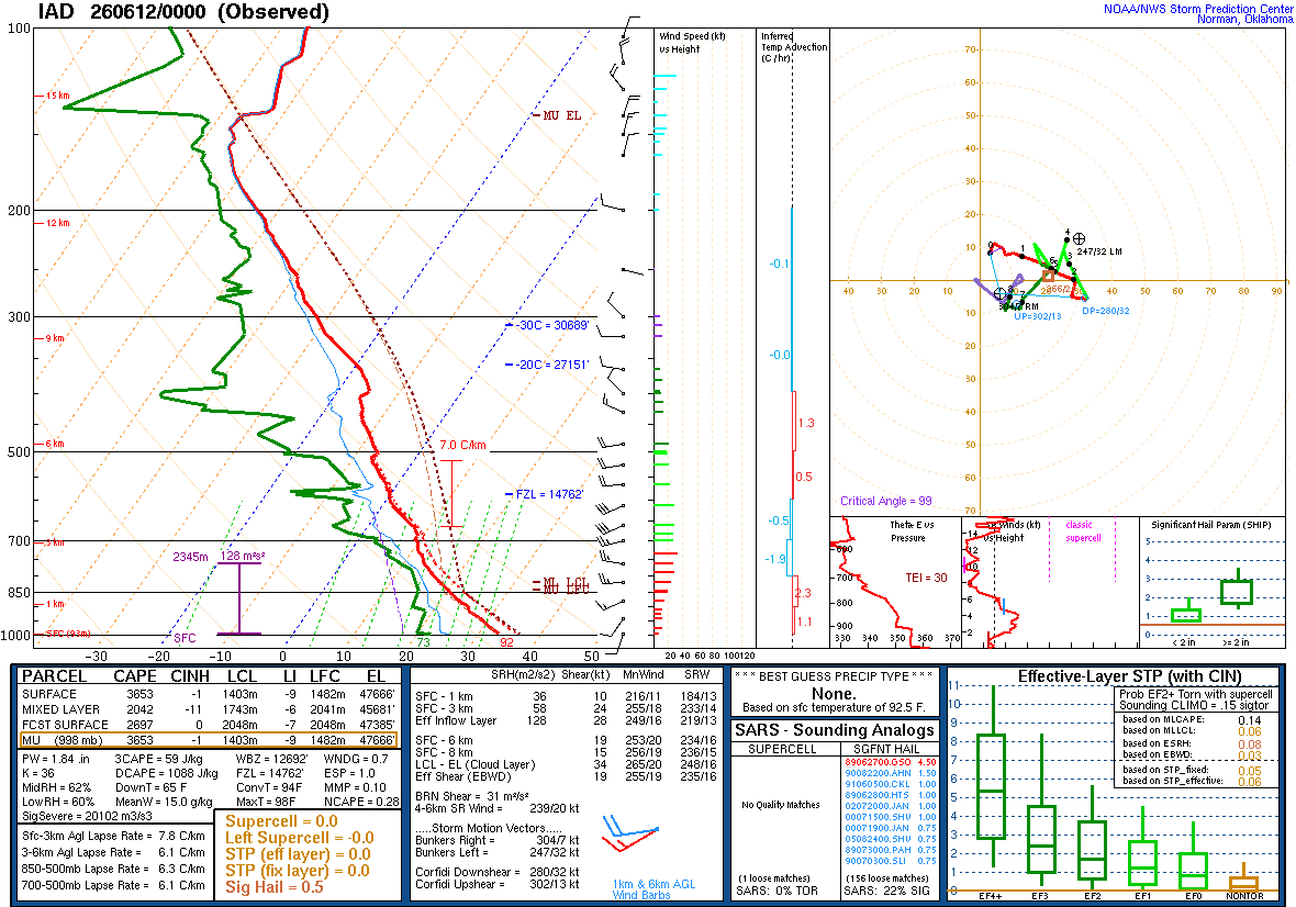
From my 3000 course Atmosphere and Weather the only thing that fully stands out is the slight rightward nudge between 500mb and 300mb. Seems odd that’d prevent a mature thunderhead considering the abundant cape still present. Maybe the other piece is the hodograph which only has unidirectional shear up to sounding point 2? Will page some of our smarter friends to help out @high risk @CAPE @MillvilleWx- 570 replies
-
- 1
-

-
- severe
- thunderstorms
- (and 7 more)
-
Junorch obs and discussion 2026
CT Valley Snowman replied to Damage In Tolland's topic in New England
Friends of mine moved from Palmer, MA to Canton, IL about 30 miles SW of Peoria last year. They've been learning the whole Midwest severe thing firsthand. i was updating them today as sirens were going off. -
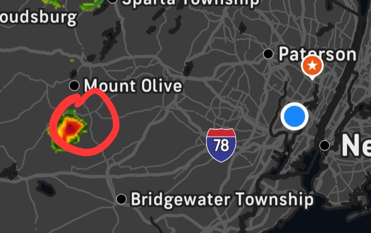
Another "Pop Up" storm is developing in between 287 and 78 north of Westfield alot of cloud to cloud lightning SVR from KOKX
-

2026 Mid-Atlantic Severe Storm General Discussion
George BM replied to Kmlwx's topic in Mid Atlantic
Sounding is in. Experts?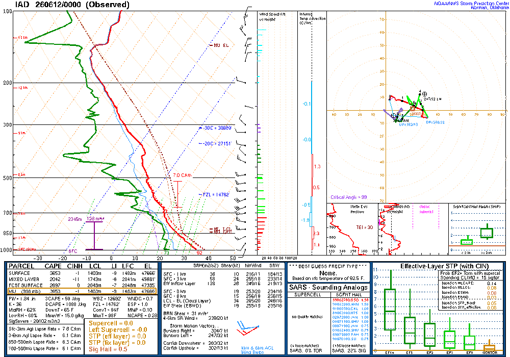
- 570 replies
-
- 1
-
-
- severe
- thunderstorms
- (and 7 more)
-
it even got its own little warning SVR from KPHI
-
2 tors likely otg SW of grand rapids
-
Indeedsnow SEZ otherwise! Just ignore the NW flow supercell in CT today. How about that 5.47" in Albany NH ydy?
-
Many members of this subforum under tornado warnings currently.
-
The lightning show that is being put on right now to my wsw of Kearny is amazing. Just non stop flashes lighting up a towering storm cloud. Has to be the single cell outwest not the main system
-

E PA/NJ/DE Spring 2026 Obs/Discussion
Birds~69 replied to PhiEaglesfan712's topic in Philadelphia Region
A little something to the W. Whatever happens it won't last long...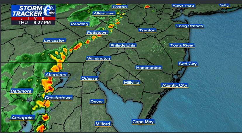
-
2026 Mid-Atlantic Severe Storm General Discussion
SnowenOutThere replied to Kmlwx's topic in Mid Atlantic
The lack of lightning does indicate how these storms were relatively low topped. Just seems odd as forecasted soundings showed a high enough EL point and we had big CAPE throughout the layer. I’m sure something caused it though.- 570 replies
-
- 1
-
-
- severe
- thunderstorms
- (and 7 more)
-
Southern and SW neighborhoods of Chicago getting hit pretty good.
-
Small cell out in this part of south west Morris County doing work… heavy rain, constant lightening and rolling thunder.
-
Epicosity between Northern Illinois and Southern Michigan One contiguous line of tornado and or severe thunderstorm warnings from Grand Rapids Michigan to Springfield, Illinois, actually all the way down to Texas
-
Lightening strikes are way down in the past few radar loops as is precip intensity. I have lightening off to my north from that cell over pike/northern sussex county, but other than that, the main show is over.
-
Absolutely insane velocity scans on that cell.
-
yeah we used to call that "heat lightning" quite a bit of it now on Union/Middlesex border being caused by a little storm that popped up near Tewksbury just north of Rt. 78
-
I honestly don't know if I've seen that color orange on a velocity sig before
-
A smidge over 0.2”.
-
100mph+ inflow from both KLOT and IWX radars. That's a yikers


.thumb.jpg.ad3a2e31d30aff035044689b311a0540.jpg)