All Activity
- Past hour
-

Central PA Summer 2026 Discussion/Obs Thread
AccuChris replied to Voyager's topic in Upstate New York/Pennsylvania
Since midnight, picked up 2.85” of rain, in the last 24 hours 3.89” and month to date its 4.58” here in Lebanon. Amazing. Anything else today will be just pure trouble . -

2026 Mid-Atlantic Severe Storm General Discussion
Eskimo Joe replied to Kmlwx's topic in Mid Atlantic
You must be new here. -
0.16 yesterday, looking like a stinker today! I'm looking forward to the nicer temps this weekend. September is my favorite summer month
-

Septorcher 2026 Discussion - Endless Summer
512high replied to Damage In Tolland's topic in New England
60/ .17" Davis/ Shop Davis 2-3 miles away .08" lol -
Yet another exceptionally unpleasant, sunless, stiflingly muggy morning. I can't WAIT for real fall.
-

Septorcher 2026 Discussion - Endless Summer
dendrite replied to Damage In Tolland's topic in New England
0.14” -
I laugh everytime they issue a flood watch for me. Lucky to get 1” of rain here most times. Crazy how it be that way sometimes. I mean feel like we used to get training storms all the time a few years back and hammered but not the past 2 years.
- 2,382 replies
-
- 1
-

-
- severe
- thunderstorms
- (and 7 more)
-
 The under is still holding strong.
 -

Septorcher 2026 Discussion - Endless Summer
tunafish replied to Damage In Tolland's topic in New England
Ha if I get more than 0.01" today I'll eat my hat. -
1.11” here yesterday. Then another 0.35 since midnight with the thundershowers.
-

2026 Mid-Atlantic Severe Storm General Discussion
dailylurker replied to Kmlwx's topic in Mid Atlantic
Absolutely! I haven't even had a real thunderstorm this year. Watching PA get crushed all summer has been frustrating. Some places up there had almost 7" of rain just last night. That's on top of 3-4" they had yesterday. Hrrr has nothing today for our area. Don't worry though. The same places in pa looked to get crushed again this afternoon. We do humidity and heat. -
Always breaks apart right before my house haha
-

Septorcher 2026 Discussion - Endless Summer
Baroclinic Zone replied to Damage In Tolland's topic in New England
About 1/2”. Heard it coming down pretty good around 4am. -
It’s not gonna make it lol
- 2,382 replies
-
- 1
-
-
- severe
- thunderstorms
- (and 7 more)
-
Seems been that way for a while south central pa into Maryland been a bust zone but western pa, northern pa and especially eastern pa been getting whacked
- 2,382 replies
-
- 1
-
-
- severe
- thunderstorms
- (and 7 more)
-

Central PA Summer 2026 Discussion/Obs Thread
mahantango#1 replied to Voyager's topic in Upstate New York/Pennsylvania
US National Weather Service State College PA As the overnight's storms push to the southeast, another round is beginning to move in from the northwest. The environment doesn't look very supportive, so this is anticipated to weaken as it pushes southeast. All hazards threat for activity later in the afternoon/evening -

E PA/NJ/DE Summer 2026 Obs/Discussion
pl0k00n111 replied to PhiEaglesfan712's topic in Philadelphia Region
I felt like I woke a ton last night from the thunder. Tired! -

Septorcher 2026 Discussion - Endless Summer
Lava Rock replied to Damage In Tolland's topic in New England
Gutner says more to come, but not holding my breath Sent from my SM-S921U using Tapatalk -
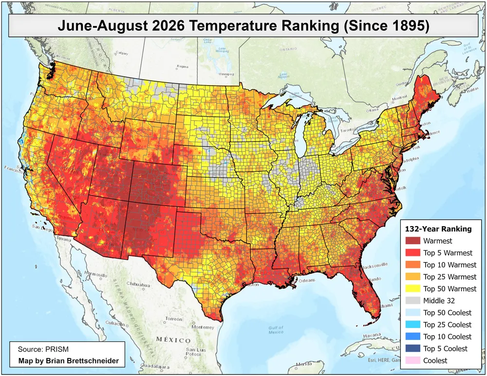
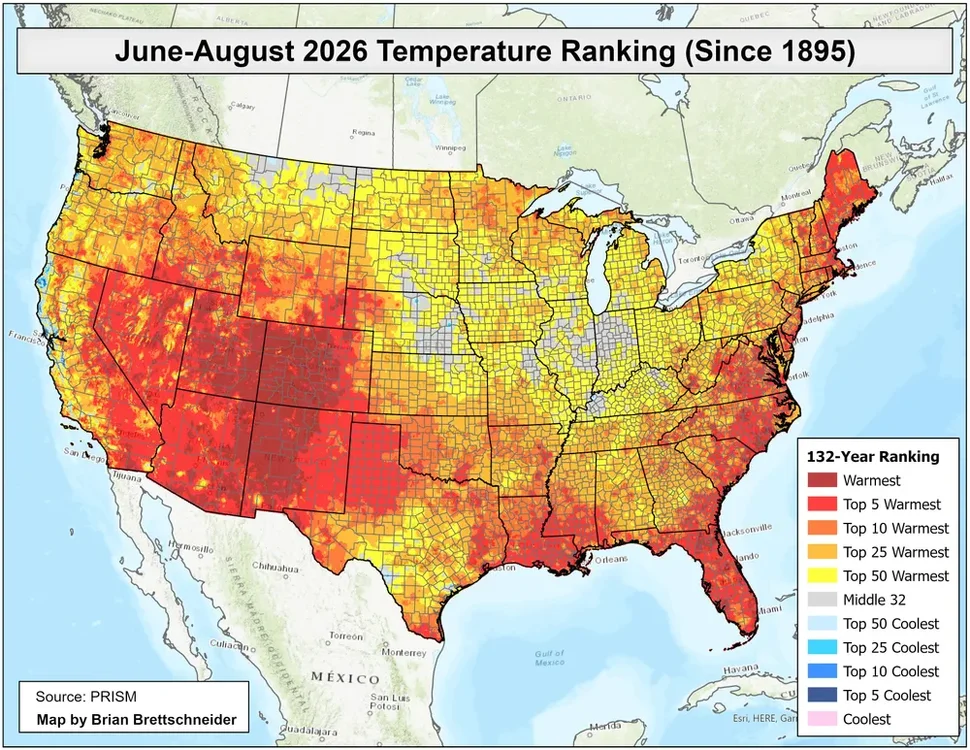
While the heat will be focused to our west, it will be the warmest September 1st to 15th for the CONUS. We’ll have to see if a piece of that heat can come east in mid-September. Models have been waffling back and forth with how far north the 90s come. Generally a continuation of the summer pattern.
-
Septorcher 2026 Discussion - Endless Summer
tunafish replied to Damage In Tolland's topic in New England
0.09" what the actual fuck. -

Septorcher 2026 Discussion - Endless Summer
kdxken replied to Damage In Tolland's topic in New England
At the very last second - Today
-
Hearing rumors that new euro is very snowy
-
Sub severe storms inbound
-

Septorcher 2026 Discussion - Endless Summer
CoastalWx replied to Damage In Tolland's topic in New England
Kind of failed -
Septorcher 2026 Discussion - Endless Summer
CoastalWx replied to Damage In Tolland's topic in New England
Of Course i caught the weakest part and it lasted 30 seconds.