All Activity
- Past hour
-
Flood Watches are up .
-
Probably our last 40s for lows until mid-late September coming up. Models transition into full summer mode after this weekend
-
The record high pressure east of Japan in association with the record warmth has shifted the timing of the rainy season there.
-
Looks COCY
.thumb.png.299de5fd39a6bd08201d3c0c91c888b7.png)
-
I would imagine after several landslides and seeing that plug in the upper valley everyone would get out fast. The before and after is nutz

-
GFS is still trying to push 90° in S NH Wed. GGEM is hot too.
-
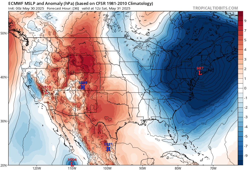
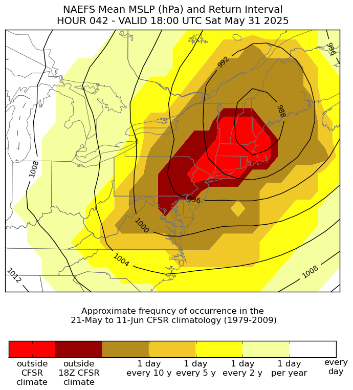
NYC metro will approach the lowest late May pressures on record tomorrow. We will probably come in about 5mb above the all-time May and June lows. 987 mb is a record for May 31st and just above the monthly lows in the low 980s. So people will be looking at their home barometers and asking what month is this.


-
Nice moisture slug down in south Jersey. Trajectory looks to be eastern Li.
-
It rained between midnight and 5 in hunt valley area I think / there’s puddles in the parking lots over here by the light rail
-
Well, THIS caught me off guard this morning.... Tonight: Showers and thunderstorms likely before 11pm, then showers and possibly a thunderstorm between 11pm and 2am, then showers after 2am. Low around 53. Light north wind. Chance of precipitation is 100%. New rainfall amounts between 1 and 2 inches possible.
-
Euro says cutoff back north again. Meh.
-
"Looking at Tuesday through the end of the week there remains a good deal of uncertainty with the mid-level pattern. Model guidance is not handling the evolution of the departing weekend system. As the cut-off low becomes more of an open trough in eastern Canada, isn`t able to easily move eastward because of the mid-level ridge across the North Atlantic. To the west of southern New England an amplifying mid-level ridge spills northeastward. Does it shift the trough out to sea or does it pinch off the trough into another closed low. If we can shift it out to sea likely a rather nice forecast with dry weather and warming temperatures. The other scenario, it becomes a closed low/cut-off and is stuck east of New England and may result in cooler temperatures and spotty shower activity. As there is a good deal of uncertainty, leaned heavily on the NBM. Which is leaning toward the first outcome, dry conditions and summer warmth. Highs in the upper 70s to low 80s and nighttime lows in the 50s." You've got to ask yourself one question: 'Do I feel lucky?' Well, do ya, punk?"
- Today
-
Yep, getting hit currently. Tropical downpour, extremely heavy rain.
-
It's been pouring early this morning here in the lowlands. Getting primed for the flooding tonight.
-
Also, zones now say sunny and hot with highs around 90 for next Wednesday and Thursday
-
Flood Watch National Weather Service Baltimore MD/Washington DC 317 AM EDT Fri May 30 2025 .A wavy slow moving frontal system will meander about the area on Friday evening into the night. Anomalous moisture coupled with high rainfall rates should increase the risk of flash flooding over portions of this watch area. DCZ001-MDZ004>006-008-011-013-014-016>018-503>508-VAZ036>040-050-051- 053>057-501-502-505-506-526-527-301530- /O.CON.KLWX.FA.A.0008.250530T2300Z-250531T0800Z/ /00000.0.ER.000000T0000Z.000000T0000Z.000000T0000Z.OO/ District of Columbia-Frederick MD-Carroll-Northern Baltimore- Cecil-Southern Baltimore-Prince Georges-Anne Arundel-Charles-St. Marys-Calvert-Northwest Montgomery-Central and Southeast Montgomery-Northwest Howard-Central and Southeast Howard- Northwest Harford-Southeast Harford-Nelson-Albemarle-Greene- Madison-Rappahannock-Orange-Culpeper-Fairfax-Arlington/Falls Church/Alexandria-Stafford-Spotsylvania-King George-Northern Fauquier-Southern Fauquier-Western Loudoun-Eastern Loudoun- Northwest Prince William-Central and Southeast Prince William/Manassas/Manassas Park- 317 AM EDT Fri May 30 2025 ...FLOOD WATCH REMAINS IN EFFECT FROM THIS EVENING THROUGH LATE TONIGHT... * WHAT...Flash flooding caused by excessive rainfall continues to be possible. * WHERE...Portions of DC, including the following , District of Columbia, Maryland, including the following areas, Anne Arundel, Calvert, Carroll, Cecil, Central and Southeast Howard, Central and Southeast Montgomery, Charles, Frederick MD, Northern Baltimore, Northwest Harford, Northwest Howard, Northwest Montgomery, Prince Georges, Southeast Harford, Southern Baltimore and St. Marys, and Virginia, including the following areas, Albemarle, Arlington/Falls Church/Alexandria, Central and Southeast Prince William/Manassas/Manassas Park, Culpeper, Eastern Loudoun, Fairfax, Greene, King George, Madison, Nelson, Northern Fauquier, Northwest Prince William, Orange, Rappahannock, Southern Fauquier, Spotsylvania, Stafford and Western Loudoun. * WHEN...From this evening through late tonight. * IMPACTS...Excessive runoff may result in flooding of rivers, creeks, streams, and other low-lying and flood-prone locations. Flooding may occur in poor drainage and urban areas. * ADDITIONAL DETAILS... - As a slow-moving frontal system tracks across the area, multiple rounds of showers and thunderstorms are possible. While initially posing a severe weather threat, a shift to a slow moving complex of moderate to heavy rain unfolds into the evening and night. Storm totals could reach 2 to 3 inches, locally nearing 4 inches in spots. - Please visit www.weather.gov/safety/flood for flood safety and preparedness information.
-
It does now for most Flood Watch National Weather Service Baltimore MD/Washington DC 317 AM EDT Fri May 30 2025 .A wavy slow moving frontal system will meander about the area on Friday evening into the night. Anomalous moisture coupled with high rainfall rates should increase the risk of flash flooding over portions of this watch area. MDZ003-VAZ025>031-503-504-507-508-WVZ050>053-055-501>506-301530- /O.EXA.KLWX.FA.A.0008.250530T2300Z-250531T0800Z/ /00000.0.ER.000000T0000Z.000000T0000Z.000000T0000Z.OO/ Washington-Augusta-Rockingham-Shenandoah-Frederick VA-Page-Warren- Clarke-Western Highland-Eastern Highland-Northern Virginia Blue Ridge-Central Virginia Blue Ridge-Hampshire-Morgan-Berkeley- Jefferson-Hardy-Western Grant-Eastern Grant-Western Mineral- Eastern Mineral-Western Pendleton-Eastern Pendleton- 317 AM EDT Fri May 30 2025 ...FLOOD WATCH IN EFFECT FROM THIS EVENING THROUGH LATE TONIGHT... * WHAT...Flash flooding caused by excessive rainfall continues to be possible. * WHERE...Portions of north central Maryland, including the following area, Washington, Virginia, including the following areas, Augusta, Central Virginia Blue Ridge, Clarke, Eastern Highland, Frederick VA, Northern Virginia Blue Ridge, Page, Rockingham, Shenandoah, Warren and Western Highland, and West Virginia, including the following areas, Berkeley, Eastern Grant, Eastern Mineral, Eastern Pendleton, Hampshire, Hardy, Jefferson, Morgan, Western Grant, Western Mineral and Western Pendleton. * WHEN...From this evening through late tonight. * IMPACTS...Excessive runoff may result in flooding of rivers, creeks, streams, and other low-lying and flood-prone locations. Flooding may occur in poor drainage and urban areas. * ADDITIONAL DETAILS... - As a slow-moving frontal system tracks across the area, multiple rounds of showers and thunderstorms are possible. While initially posing a severe weather threat, a shift to a slow moving complex of moderate to heavy rain unfolds into the evening and night. Storm totals could reach 2 to 3 inches, locally nearing 4 inches in spots. - Please visit www.weather.gov/safety/flood for flood safety and preparedness information.
-

2025 hurricane season forecast contest -- enter by June 1st
vpbob21 replied to Roger Smith's topic in Tropical Headquarters
15/7/4 -
So my week total is 2.27 with a monthly total of 9.47. With the potential of the rains tomorrow night will most likely go over 10” for the month.
-
Yeah, forecast soundings along the warm front certainly support at least transient supercell structures. The question is where the warm front will reside, as there isn't good model agreement. If there is a weak consensus, it's for the warm front to set up just south of DC. Saturday could be a hail threat throughout the area, as very cold temperatures aloft will be in place, and the secondary front looks to move through at a favorable time of day.
- 777 replies
-
- 3
-

-
- severe
- thunderstorms
- (and 2 more)
-
Maybe, but in fairness people evacuate (or not) based on complex factors and circumstances.
-
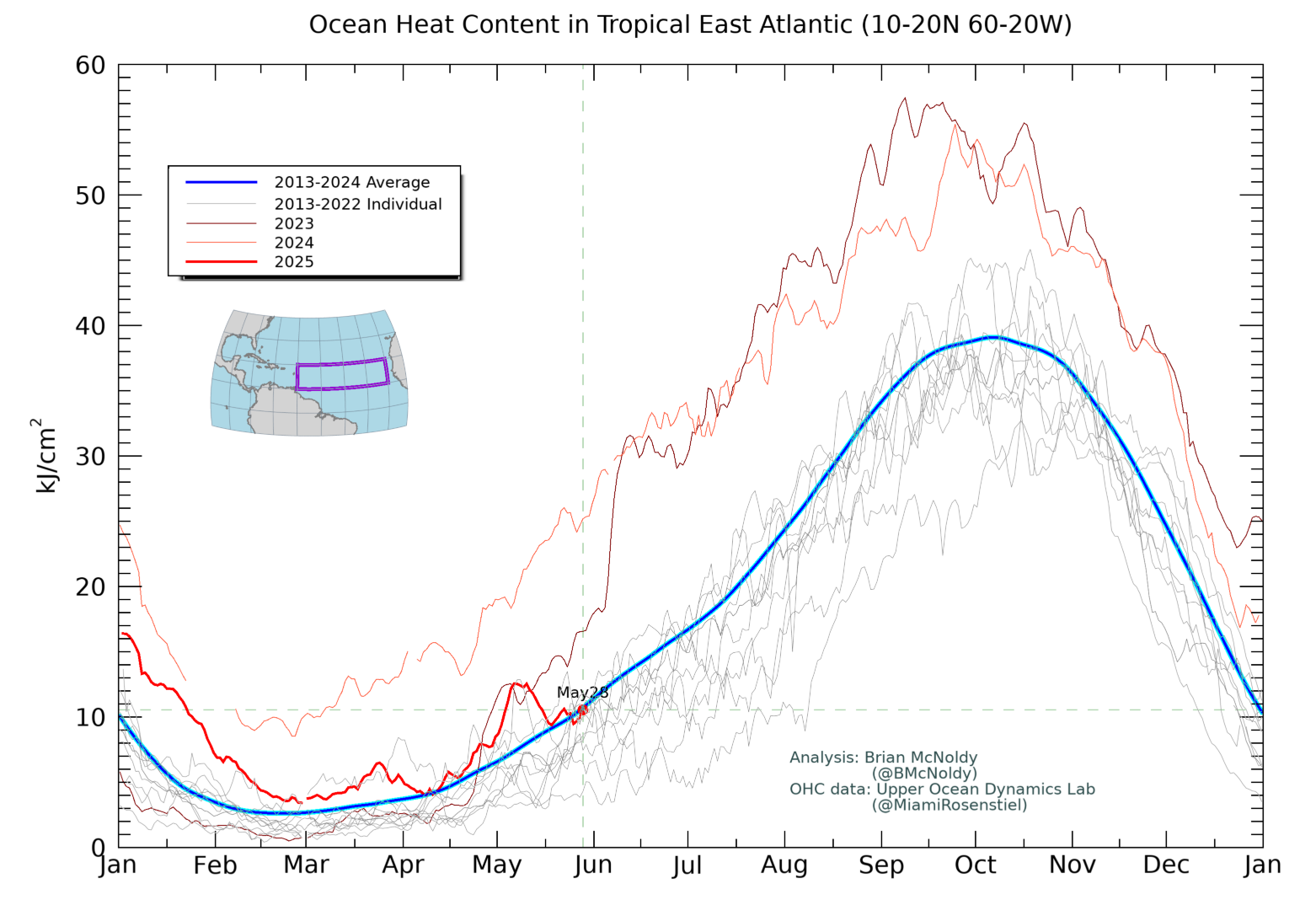
As of May 28th, OHC for the area of the tropical Atlantic east of the Caribbean (20W-60W) is down to near the 2013-24 average. That’s still quite warm, but it’s not nearly as warm as 2024 and is even a bit cooler than 2023. I’ll be interested to see where it is in a couple of weeks:
-
Every time it’s halfway decent out, our course seems packed. You can never make up full for bad days but it’s been good to be busy when you can.
-
In my house, any husband who didn't call yesterday like he promised would be sent packing. I don't mess around with not having air conditioning.
-
00z NAM Nest looks interesting... granted the storms weaken by the time they get up here... but those look nasty in the SW parts of the LWX CWA


.png.250711152973cacc1c15816ac27241bd.png)