All Activity
- Past hour
-

January 2026 regional war/obs/disco thread
dendrite replied to Baroclinic Zone's topic in New England
Eagles? -
Pardon my ignorance but to get such an overrunning event don't we need a negative (or neutral) PNA since the wave is from the southern stream and tracks eastward across the country? Wouldn't a positive PNA block it's path or force it to be significantly weaker/disjointed as part of it goes over the ridge and part goes under?
-

Central PA Winter 25/26 Discussion and Obs
pasnownut replied to MAG5035's topic in Upstate New York/Pennsylvania
Yeah I knew Kutch would look better than run of the mill 10:1, but didnt want to sound like I was hypin somethin up -

Winter 2025-26 Medium/Long Range Discussion
sbnwx85 replied to michsnowfreak's topic in Lakes/Ohio Valley
Incredible run. Put it in the Hall of Fame. While we obviously don't expect 40+" of snow, it's worth keeping an eye on if the signal for a massive storm is still there by the end of the week. Could be something special. -
Temps just above freezing, but it's night, so maybe stickage on a few surfaces? That said, the CAM suite consensus is for just a little bit of snow at the end, with the area of snow expanding after crossing the Bay. One thing to watch for all of us is that any wet spots could freeze early Thursday as temps drop quickly behind the front.
-
Late January looks interesting.
-
I hope it trends in our favor in the coming days. Because right now even though the ensembles look cold, that system looks like it wants to cut as the PNA dips well into negative territory. Maybe the PNA will trend toward neutral and we get better cold press to keep the wave just south of us.
-
44” for me by the end of the month? I will go for the under on 6” for the balance of the month.
-

Central PA Winter 25/26 Discussion and Obs
MillvilleWx replied to MAG5035's topic in Upstate New York/Pennsylvania
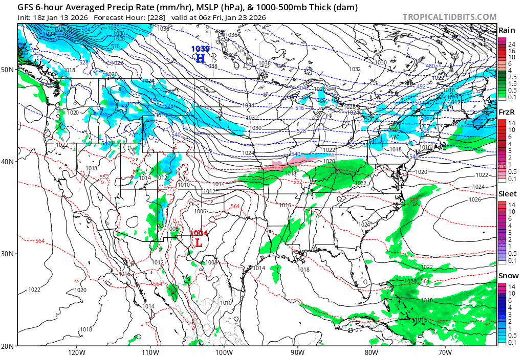
Hey y'all!! Wanted to drop by and say we are looking closely at that time frame between the 23rd thru the 30th this month for active weather potential. SWFE type pattern that tends to have good promise for the state. Obviously where the baroclinic zone ends up is the key in all this, but the pattern shaping up seems to be trending in that direction. This has been on many Met's radar's for the past week or so and seems to be holding weight. GFS run was obviously the most extreme fantasy you'll ever see for the pattern (Not happening), but the type of setup is certainly plausible given the confluent area to the north and a weakening SER to our south. For now, just some clipper and squall type snows as the troughing pattern returns for a period. -

January 2026 regional war/obs/disco thread
WinterWolf replied to Baroclinic Zone's topic in New England
I know…it was just that at 12z…not one of them came close to getting us with anything, the entire 384 hrs. -

2025-2026 ENSO
donsutherland1 replied to 40/70 Benchmark's topic in Weather Forecasting and Discussion
I suspect that the recent EWB had an impact. La Niña is still exerting an influence. -
Glad you enjoyed that pic, Wait until i do a photo dump after the next 2 days, Banter on!
-
Unless it’s a Modoki Niño
-

Pittsburgh/Western PA WINTER ‘25/‘26
colonel717 replied to Burghblizz's topic in Upstate New York/Pennsylvania
3K and FV3 show 1-3 for tomorrow. Cut back some. -
January 2026 regional war/obs/disco thread
WinterWolf replied to Baroclinic Zone's topic in New England
Maybe he’ll drive down and join him in the same locked room even… -

2025-2026 Fall/Winter Mountain Thread
Maggie Valley Steve replied to Buckethead's topic in Southeastern States
Source: Peakbagger.com https://share.google/hKp2XlFoHugG7B0pL -
Now I know why the digital snow thread is making a comback.
-
Central PA Winter 25/26 Discussion and Obs
str8liner replied to MAG5035's topic in Upstate New York/Pennsylvania
Please baby Jesus, just one time lol. Heck I would be happy to have enough to even get the snow blower out. -

Pittsburgh/Western PA WINTER ‘25/‘26
MikeB_01 replied to Burghblizz's topic in Upstate New York/Pennsylvania
That’s what I see when I dream at night . -
Exactly...what if
-
Looks like a weenie hacked into the models.
-
Pittsburgh/Western PA WINTER ‘25/‘26
colonel717 replied to Burghblizz's topic in Upstate New York/Pennsylvania
EURO had a huge one last Feb for Upper OHV thru Michigan, but not as much widespread as this one. -
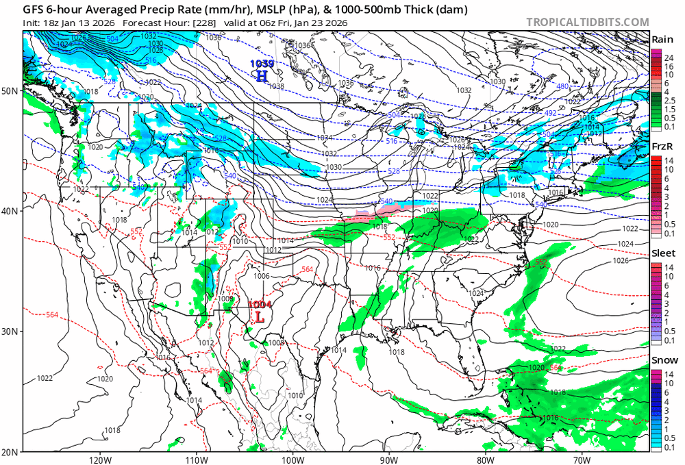
The 18z GFS output verbatim is an extreme fantasy. However, the pattern shaping up around that time absolutely screams some type of SWFE type event that could involve a large areal coverage. Something we are keeping an eye on at range. For now, it's not real life, it's just fant-....oh, you get it.
-
If the -AO is for real that’s being shown. The MJO may have no say so in the matter. One thing even the wx office here in Nashville has said in the past. “A -AO almost always means it’s going to get really cold here.” So we have a -EPO -NAO -AO. That’s a heck of a trio for us to have.
-

Pittsburgh/Western PA WINTER ‘25/‘26
RitualOfTheTrout replied to Burghblizz's topic in Upstate New York/Pennsylvania
Just putting this here for posterity.