All Activity
- Past hour
-

Pittsburgh/Western PA WINTER ‘25/‘26
Ecanem replied to Burghblizz's topic in Upstate New York/Pennsylvania
Hrrr 0z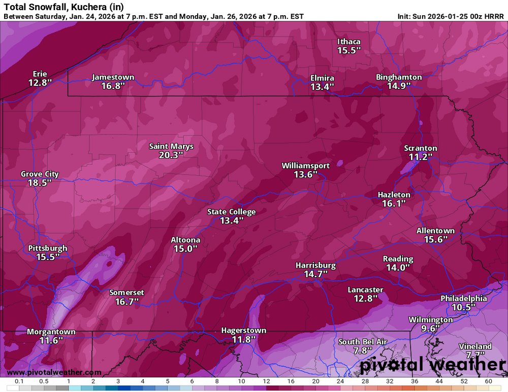
-
 esoscale Discussion 0049 NWS Storm Prediction Center Norman OK 0746 PM CST Sat Jan 24 2026 Areas affected...Northern Louisiana into eastern Arkansas...northwest Mississippi...and far western Tennessee Concerning...Winter mixed precipitation Valid 250146Z - 250645Z SUMMARY...Another round of freezing rain and sleet is expected to spread out of northern Louisiana into eastern Arkansas and northwest Mississippi. Freezing rain rates upwards of 0.05 inch/hour appear likely for some locations. DISCUSSION...Recent radar mosaics show a developing plume of precipitation across central to northern LA - likely associated with strengthening warm advection between 925-850 mb. Over the next several hours, an uptick in low-level winds should promote further augmentation of isentropic and frontogenetical ascent across the lower MS River Valley. Regional 00z RAOBs from SHV and LZK sampled a stout (4-12 C) warm layer between 850-700 mb that will melt hydrometeors as precipitation spreads north/northeast. Sub-freezing surface temperatures will promote some degree of re-freezing near the surface, though locations with temperatures at or near/below 15 F will likely be sufficiently cold (and have a sufficiently deep sub-freezing layer) to promote sleet as the predominant precipitation type. Warmer locations will likely observe freezing rain (with freezing rain rates up to 0.05 inch/hour) with periods of sleet possible. Based on latest surface observations, freezing rain appears most probable across southeast AR into northwest MS with sleet more likely for locations further north into east-central AR and far western TN.
 -

Extreme Cold, Snow & Sleet: SECS 1/24 - 1/26
jm1220 replied to TriPol's topic in New York City Metro
They could still be right. We’ll see what they say at 0z then I’d say it’s time to look at radar trends and start to buy more into the short range models. -

Extreme Cold, Snow & Sleet: SECS 1/24 - 1/26
Snowlover11 replied to TriPol's topic in New York City Metro
Nam is on its own currently pushing the mixing that far north. Lets see the rest of 0z before bridge jumping here. -
 Holding steady at 30.4. I’d guess and say I have .20 accumulated. My willow has branches already on the ground, Bradford pear has branches sagging. Road conditions don’t look that bad. .
 -

January 24-26: Miracle or Mirage JV/Banter Thread!
snowfan replied to SnowenOutThere's topic in Mid Atlantic
Ha....I always need to downsize them so I can upload them here. So I snap the Pic, load into an app I use and the bw conversion is just a personal preference sometimes. -
Let the NAMs go.
-
Can’t believe it but I have sleet mixed with snow right now
-
3k nam said I would have nothing by 9pm and I'm just shy of an inch. Also show my temp @ 19 and I'm still 14. 3k could have the sleet timing correct but it missed an inch of snow already
-
Pittsburgh/Western PA WINTER ‘25/‘26
Ecanem replied to Burghblizz's topic in Upstate New York/Pennsylvania
It’s for one frame and goes away.
-

January 24-26: Miracle or Mirage OBS Thread!
SnowenOutThere replied to Jebman's topic in Mid Atlantic
Sounds like middle earth -

Extreme Cold, Snow & Sleet: SECS 1/24 - 1/26
Winterweatherlover replied to TriPol's topic in New York City Metro
I know the NAM has nailed warm tounge events well, on the contrary has it had any significant fails in this situation in the past? -

Southern Crippler - Get well soon Jimbo Storm Obs
Regan replied to BooneWX's topic in Southeastern States
Yep. Sleet and freezing rain mix near Angus Barn in Raleigh. There’s a thin glaze on everything. -

Central PA Winter 25/26 Discussion and Obs
Jns2183 replied to MAG5035's topic in Upstate New York/Pennsylvania
In Arkansas it was best model for snow. The GFS, euro were close. Sent from my SM-S731U using Tapatalk -
Really hoping this storm doesn’t Nam me
-

2025-2026 Fall/Winter Mountain Thread
Buckethead replied to Buckethead's topic in Southeastern States
Wow. I've climbed to 29 now with a strong SW wind. Sent from my Pixel 10 Pro using Tapatalk -
My area seems to be close to where the transition could reach (discounting the NAM), but it should also be poundtown for a while before then. A solid 12+ is what I’m thinking for just west of MMU.
-

Pittsburgh/Western PA WINTER ‘25/‘26
colonel717 replied to Burghblizz's topic in Upstate New York/Pennsylvania
Also if it's real it's towards end of storm not early on. Also hope it's sleet and not frz rain. -

Richmond Metro/Hampton Roads Area Discussion
Conway7305 replied to RIC Airport's topic in Mid Atlantic
Radar filling ion nice. Some heavy stuff out West. Maybe it’s just me but the rain snow line seems way down in North Carolina. -

Southern Crippler - Get well soon Jimbo Storm Obs
Berlin1926 replied to BooneWX's topic in Southeastern States
16 down from 19 an hour ago and moderate snow in Midlothian, VA -
I hope so, because the NAMs sure as hell ain't.
-

“Cory’s in LA! Let’s MECS!” Jan. 24-26 Disco
Damage In Tolland replied to TheSnowman's topic in New England
Monday looks even better then 18 zed -

January 25-26 Winter Storm Potential
Ralph Wiggum replied to Ralph Wiggum's topic in Philadelphia Region
1z hrrr coming in colder again. Hmmm. -
Central PA Winter 25/26 Discussion and Obs
Jns2183 replied to MAG5035's topic in Upstate New York/Pennsylvania
It's driving me nuts. Something is there but after how I saw it do so far, a pixel analysis correlation of .18 vs every model being 2.5x-3.5x higher because of how bad it screwed up the changeover line Sent from my SM-S731U using Tapatalk -

January 24-26: Miracle or Mirage OBS Thread!
EastCoast NPZ replied to Jebman's topic in Mid Atlantic
Good luck, everyone. May God and fortune be with us.


