
All Activity
- Past hour
-
Thunder… probably from the cell near Bel Air
-
It got sunny as soon as those stormed moved thru, which was nice
-
light rain starting here
-

Central PA Summer 2026 Discussion/Obs Thread
canderson replied to Voyager's topic in Upstate New York/Pennsylvania
Another day, another day of storms where you have to be S of Rt 30 to score. -
severe watch just got expanded WAY west, covering i think all of ILN's FA now. pretty surprising, given neither the hrrr or rrfs develop much (if any) convection here through sunset.
-
Bark is worse then the bite right now north of Harrisburg -no warnings north of Harrisburg - many warnings below Harrisburg Severe Weather Warnings Page
-
I havent looked but are we dealing with some smoke again?
-
90 / DP : 67
-

2026 Mid-Atlantic Severe Storm General Discussion
SolidIcewx replied to Kmlwx's topic in Mid Atlantic
A bust would almost be as bad as smoking cirrus when a low passes to far to the east in winter. -

2026-2027 Record-breaking El Nino
bncho replied to Stormchaserchuck1's topic in Weather Forecasting and Discussion
@40/70 Benchmark@BlizzardWx @bluewave @Ephesians2 Thanks for the informative responses! Your points all make sense and continue to help me learn. -

Spring/Summer 2026 Pattern Discussion Thread
dwagner88 replied to Carvers Gap's topic in Tennessee Valley
Interesting point forecast for Friday.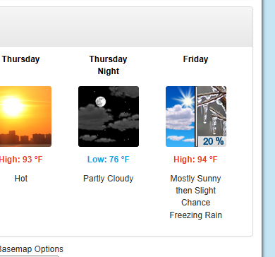
-
be tough to bust at this point (famous last words)
-
Weather Underground is not that reliable some of those stations have crazy low or high numbers. Seems like the line in central - eastern PA is splitting no warnings in the northern half above Harrisburg
-

2026 Mid-Atlantic Severe Storm General Discussion
wxmeddler replied to Kmlwx's topic in Mid Atlantic
You've recovered nicely. The area is still 5-7 degrees cooler than south of I-70 but it's recovered a lot faster than I expected. -
STW just issued for 80 mph gusts and golf-ball sized hail. Warning box is 1/2 mile to my north.
-
Yeah my area a little west of NYC usually has one of the lower dewpoints in the tri-state. Newark has a dewpoint of only 65 right now too.
-

E PA/NJ/DE Summer 2026 Obs/Discussion
RedSky replied to PhiEaglesfan712's topic in Philadelphia Region
SEVERE THUNDERSTORM WATCH OUTLINE UPDATE FOR WS 556 NWS STORM PREDICTION CENTER NORMAN OK 210 PM EDT MON AUG 10 2026 SEVERE THUNDERSTORM WATCH 556 IS IN EFFECT UNTIL 900 PM EDT FOR THE FOLLOWING LOCATIONS PAC011-017-025-029-045-077-089-091-095-101-110100- /O.NEW.KWNS.SV.A.0556.260810T1810Z-260811T0100Z/ PA . PENNSYLVANIA COUNTIES INCLUDED ARE BERKS BUCKS CARBON CHESTER DELAWARE LEHIGH MONROE MONTGOMERY NORTHAMPTON PHILADELPHIA -
I see a lot of ice storms for the interior.
-
Cold and snowy is my call Historic El Nino. NYC will see 100 inches of snow.
-
is the dew point from your weather station ? I looked on Weather Underground and there is a wide range of dew points from 65 up to 75 area wide
-
17z run of the HRRR hits us pretty good around 7-8pm. We shall see.
-
 CPC disregarding it completely. The CANSIPS has looked like the 2 years in a row, and the last 2 Winters did verify like that. I remember in July last year though it had a 0.0 month lead in the Midwest of -4 to -6 for the month and it ended up being like +2 to +4 lol.
 -
Gun to head a similar progression to 2016 is my thinking. Probably a not so great start to winter transitioning colder as it goes along. People forget how close we were to more snowstorms in Feb and March in 2016. It didn’t come together but the pattern was decent from Jan 15 on
-
I think the model is overestimating the NAO: We aren't going to get extreme cold in the east with the N. Pacific looking like that.
-
88 with a dewpoint of 65 here right now. At least the humidity isn't terrible today.


.thumb.jpg.ad3a2e31d30aff035044689b311a0540.jpg)









