nrgjeff
-
Posts
4,251 -
Joined
-
Last visited
Content Type
Profiles
Blogs
Forums
American Weather
Media Demo
Store
Gallery
Everything posted by nrgjeff
-
Nice evenings and mornings make warm afternoons in the 80s easy going this week. Except Friday could hit 90 which will feel hot. Prefrontal warming strikes before a cool weekend. Looking out a week the next warm up is weaker, as one would expect deeper into September. Great Lakes trough will take a couple short-waves to cool down our region. See Friday prefrontal heat. Later next week after the Great Lakes mean trough fills, 500 mb heights should remain at or below normal in the Southeast. Midwest warmth should get into the Mid-South at times but it should be brief.
-
2010-2011 winter had the White Christmas in Chattanooga, storybook with 3-4 inches of snow that morning. Then we got hammered 8-10 inches mid-January. I think one other true accumulating snow happened (Dec 13 or 14). Then we got a few little dustings. IIRC it was a good year from the Mid-South to the Great Valley.
-
I'm split on that. Do we need crazy cold source regions? Probably for sustained retro cold. Doubtful for quick intense shots like we get. Long as the AO flips cold will get delivered somewhere in the mid-latitudes. Other teleconnections help forecast exactly where, but as we've discussed it gets nebulous in the last decade or two. One thing to note is a marine heat wave across much of the northern Pacific Ocean. Parts of the Atlantic are similar. Mercifully it's not all in the Tropical Atlantic. Some hypothesize, and after some success we could say theorize, warmer oceans up north create conditions favorable for blocking. I'm talking general blocking -AO not necessarily cold air destination. So while warm oceans could promote a mild fall, warm SSTs could also set up some winter blocking. Current situation is an example of how it can be warmer than normal in Western Canada, while the Southeast is cool. Well that's an old teleconnection too, but for sustained cold the source does need to reload.
-

Fall/Winter Banter - Football, Basketball, Snowball?
nrgjeff replied to John1122's topic in Tennessee Valley
The flow Wednesday night into the weekend, and the system Thursday, would be really great in the winter, esp after the Sunday then Tuesday fronts to put cool air in place. Well somebody had to say it. I have done my duty! -
Disrespectful is a good way to describe foul weather. I'll have to remember that! Yeah the worst heat should break for the season after today (Wednesday). Some folks I-40 north are already in the new airmass. Still cookin' south of the front! As usual I forecast this first CF to be weaker than progged. NAM 2m is too cool. MOS and NWS are on that with average highs (aggregate region) 88-90 through Sunday. Some will enjoy 80s esp up on the Plateau and near Kentucky. The rest of us will have to wait for front #2. Clark she's a beaut! -Cousin Eddy First front is mostly low levels behind Erin with only modest Td improvement. Second front for Monday has true upper air support with trough over GL even OV. That'll deliver for our Tenn Valley including scouring some dews. Then the trough pattern seems to hold for a week to 10 days from Monday. Looks like it might warm up again after Labor Day but we're talking around 90 with lower humidity and ever lower sun angle. That'd doable.
-
Fortunately we all got home before all the flash flooding in Hamilton County. Usual trouble spots got bad, and few new problem areas showed up. So far it's the second highest daily rainfall at KCHA. First was around Labor Day 2011 but that was over a longer period all day. Today was pretty much all in a few hours. Others in the Chattanooga area and also Bradley County, please check in when you have a chance. Today was intense.
-
Eastern Valley has more chances to get rain especially Tuesday. Not everyone got it the past 7 days but more chances are coming. I'm happy the Eastern Valley heat got pushed back a few more days. With any amount of luck the heat this weekend, book-ended by similar weekdays, could be the last of the worst of summer. Depending on how any tropical cyclone behaves the heat ridge could either be augmented or chipped at. Either way prolly a few hot days here. Toward the end of August we might be able to trim dewpoints even temps creep back up. Late August fronts don't help temps much past 1-2 days* but they and chip away at dews. Either way the sun angle gets noticaby lower which takes the edge off midday too. Late August sun angle is the same as mid-April. LOL the temps part! *Apparently early August fronts set record low maxes though.
-
I'm back after recovering from end of summer family trip and beginning of school. @Carvers Gapmy delayed response to the ECMWF monthlies pretty much sums up my enthusiasm. SSTs could help blocking, but I can't beliee it. Plus we could run into meh cold in the source regions. Clusters each month are about 50/50 with a warm cluster of course each month. I figure one of those months could come in colder than normal. Feels like either Dec or Feb. January thaw seems popular recent years. In this case it's flat ridgy under the Midwest cold. Too early for a real forecast so I like what @*Flash* posted. Sorry Dallas Cowboys fans! Texas was the first thing I really noticed. Midwest and Plains are funny too.
-
Lightning was impressive both times here in Chattanooga. Today it was vivid enough to be noticeable during daylight along with crashing thunder. Wednesday night was the more traditional summer evening light show and (mostly) rolling thunder. We had one crash boom last night too that made the normally oblivious cat jump!
-
Of course we have to pay our dues before that front the first of August. As the hot ridge compresses (Midwest to South) the heat will crank up all over the Valley. This week was Mid-South focused; next week will get all the way east - and probably more intense everywhere. I figure we will enjoy that break the first of August. Even normal temps will feel refreshing esp. with lower dews. I suspect we're not done with heat though. Usually takes multiple pushes to break the pattern. That said next week should be the peak of summer. Slight above later in August is my feel. Nothing horrible, but the typical slow transition to football weather. Tropical CAVEATs: East Coast phase could help a milder pattern settle in. Western Gulf landfall would just amp up the ridge and add humidity (pulling dews inland) in Aug.
-
John I'm sorry for your loss. Cancer took both my parents. Thinking of you and all of your family. This community also misses your dad. Yeah he was solid on the weather side and insightful in politics. I remember great weather discussions for the Southeast though I'm Tennessee Valley.
-
Same story. Storms just kept coming Monday. Turning over the atmo didn't matter. Storms seemed to redevelop on a boundary. Well the extended forecast calls for more heat, humidity, and suffering. The mild start to summer was nice, but it's ancient history now. First thought the July heat might break for August. Looks more like low key heat continues after the true heat wave breaks. Wake me up in September. Prolly still be hot, but likely less humid, and definitely a lower sun angle. Football too.
-
The Split was real on Tuesday. However, MBY did fine the previous several days. After the hot temps July 4-8/9 the benign weather pattern is still forecast for a good chunk of July. Forecast looks seasonably hot but temps not much if any above normal. Greater anomalies should be north. CFS has the GL mild but it's an outlier. EC and GEFS weeklies have a hot Midwest, but that's OK. AN heights north leaves ours near normal, which will allow scattered pm t-storms. The latter two weekly products also line up with most teleconnections. Very end of July is still up in the air. The PNA pattern may get stale by then which would let in more heat, but not necessarily for long. We'll see.
-
Torandoes after June 1. Yes they used to happen even in the South. Recent years we cannot hardly buy action after May 15. This year it went later into May with that southern stream south of the AN heights North. Plains actually had a June season this year too. But the last several years the season either ended early or moved north quickly. Anyway it's July. Our next chance of anything more than downbursts would probably be hybrid tropical remnants. Jax our posts would flow fine without a quote.. except it's a new page!
-
4th of July front is a couple days early this year, but yes it seems almost obligatory recently. Could be hot again on the 4th though. While temps will be above normal Friday through early next week, the humidify will not be what it was last week. I call it hot but not a bad heat wave. Starting around July 10 temps may settle to seasonable (hot but doable). PNA and GWO are friendly to the Southeast. Two paths are offered. CFS is weak heights Great Lakes, but Texas ridge could pulse into the Mid-South at times. Euro is AN heights North which can sometimes ooze South. Either pattern is friendly for less sustained heat here, perhaps even normal temps.
-
Yeah @Matthew70 more flooding is a verified trend. Makes sense with greater average Theta-E in the Atmo warmer and with more water vapor. Guess the rest of this discussion is over in climate wars, lol! Climate Change in the General thread section. I remember Alaska had a hot week. That's why social media is not great for breaking weather. Love seeing week old warnings. Even phones give week old stories in notifications. Like yeah, I already know I missed the Northern Lights last week! Anyway let's talk July. We get more t-storms through the weekend into Tuesday when a weak Fropa is forecast. Per usual in July the one day of nice high press evolves into hot high press. Might be hot again starting around the 4th of July, but not as nuts as this week. Indeed, another hot spell (trying to avoid heat wave language) is forecast around the July 4-6 weekend into the following week. Atmo appears to be working off this heat wave still, with a lingering ridge sloshing around Texas and the Mid-South early next week. If all goes well the rest of July looks closer to seasonable. Highs around 90 instead of into the 90s would feel great now. Most teleconnections and GWO / GLAMM etc want to trend to heat North and West with normal Southeast. Euro weeklies does less Great Lakes ridgy which would better ensure reasonable temps here. CFS connects 'em which leaves us open to heat spikes. We've had years before that got hot early and then went near normal. 2012 comes to mind as one that truly went normal later in summer, vs lingering slight AN. We'll hope for the 2012 version.
-
Alaska does not have any Heat Advisory. NWS website does not show any heat products in effect up there. Just a flood for snow-melt near Fairbanks. High temps 70s inland 60s coast, lots of rain forecast. The sun can shine all day, but it's at a low angle for many of those morning hours and evening hours. Then it still goes to dusk no sun below the Circle. From the wrong high temps to the sensational sun quip, the social media post is detached from reality. Meanwhile looks like our heat will ease up East later this week with t-showers. West gets to suffer more. Then showers and t-storms cover more ground this weekend. Models have a minor fropa next week. More precip. While it drops temps only a few more degrees, it prevents any upswing. Hopefully the previous wet not too hot trend flexes and the current heat wave is just one of a couple surges this summer. Just say no to prolonged heat.
-
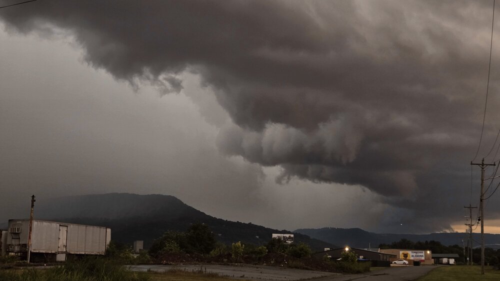
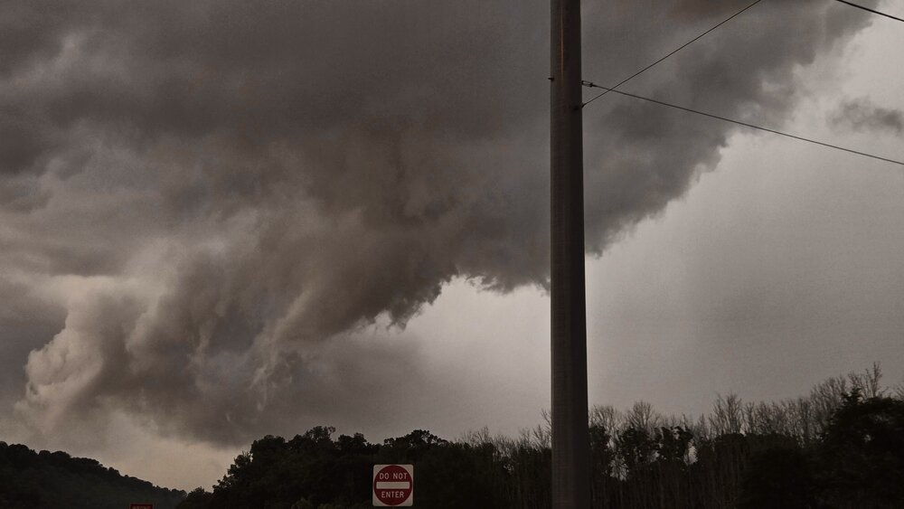
Chattanooga got it Saturday! Several thousand power outages were reported, something like 12K+ I estimate about 50 mph gusts at my location. Other parts of the city, instruments measured 60-70 mph. Saturday in Chattanooga and surrounding areas was a classic bow echo.
-
Mid-range models are hinting at Friday Hoosier Alley. Wrong Region? Nah, ours is the best region and it's close, ha! Also unruly outflow boundaries south of progged could push that closer to our Mid-South, though probably not anything rotating. Better shear is Hoosier Alley. SPC hints at it in their 4-8 day text but I agree it's a bit early for a 15% valid Friday. I just gotta talk weather. Ventured into the off-topic toilet bowl this morning. SOS!
-
Yes this weather is unusually comfortable for the beginning of June now. Too bad we're smoked out. While social media argues about the +/-Bz and Aurora Sunday night, we can just go to bed early. No chance with the smoke anyway. So, enjoy the mild temps and low RH.
-
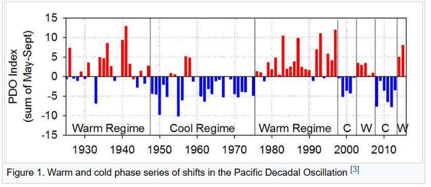
Given the PDO is erratic, their study may be valid. Who knows if the Atlantic will ever cool off? Scientific consensus across all Journals is evolving. Or, we lack understanding to model the causation. Either way, the historical record may be useful. What's North American 2m temperature do with different states of the Atlantic and Pacific (and combos)? Instead of treating them as predictable oscillators, just take the Ocean temps at face value during this or the upcoming season. Both negative is going to be a cold possibly snowy winter for many. Both positive is going to be grill out and drink for many. If I was going to pick on oscillator to quit, I'd punt the QBO. It's rate of change could be useful, but its steady state has not been useful since George Bush was president.
-
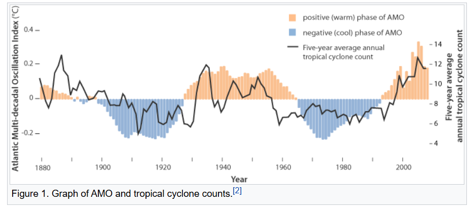
Soon we are due to go negative AMO. Keep in mind soon is measured in years. Here is a smoothed chart from an energy climate page. Yes, some energy companies acknowledge it. We better, if our demand forecasts are going to be worth anything. Then the PDO has been a little flaky. It faked out cool phase a few times since 2000. Will it be able to hold? Perhaps the warmer background makes it harder to stick. So, I'm very curious how the AMO goes in the coming decade. Both negative could be epic winters!
-
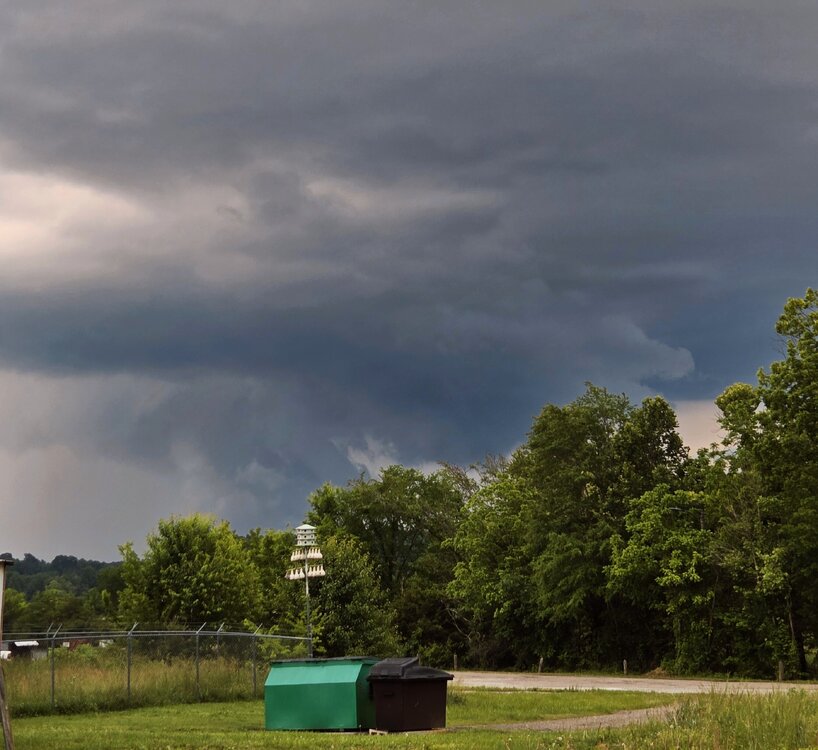
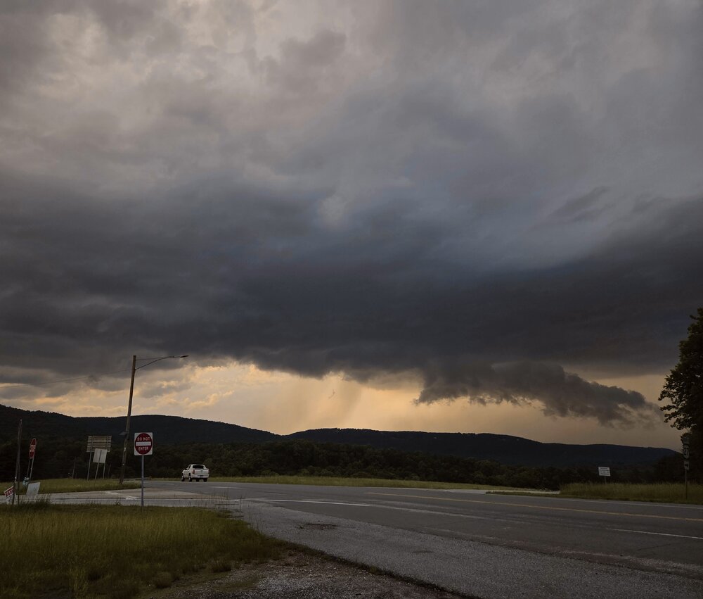
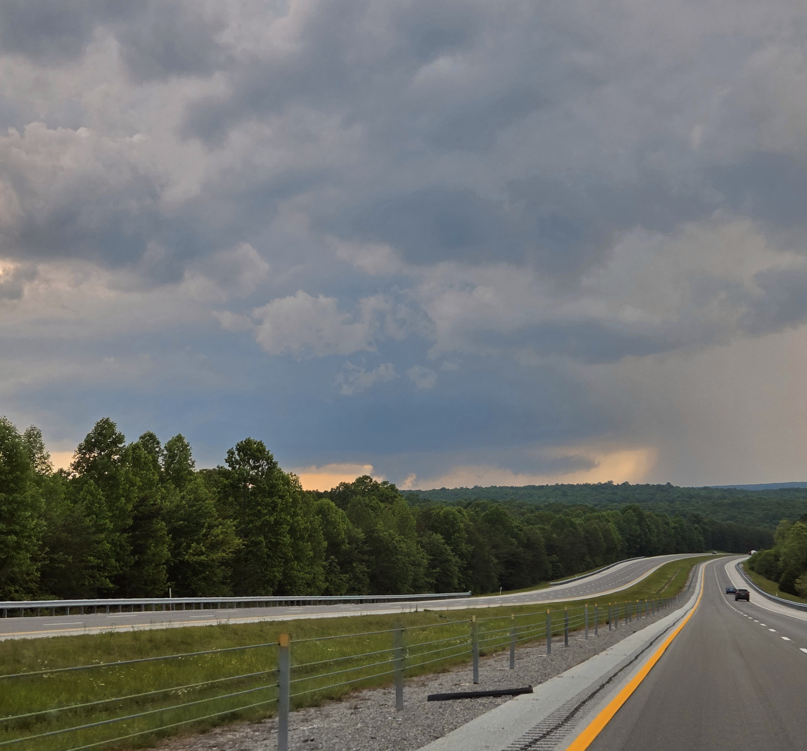
I took a little Sunday drive to South Pittsburg, Tenn. No it's not far. South Pittsburg shelfies! Separately thank you to all Veterans to who serve(d). Especially we remember those who are fallen for our freedom.
-
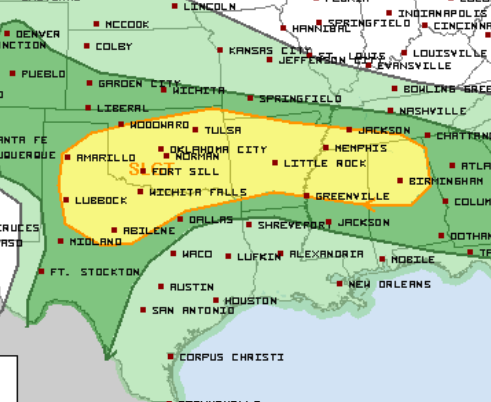
SPC is talking outflow boundary isolated tornadoes both Saturday and Sunday. The Saturday boundary and outlook is south of most of us, as expected with a morning through midday MCS. Sunday is below. Smaller morning MCS is forecast, and it could break up and allow redevelopment Sunday afternoon. Monday could be similar. While it's 3 days in a row it's Marginal-Slight, so not a huge deal. Still I find it quite interesting so late in the season. Sunday is below, updated Friday afternoon.
-
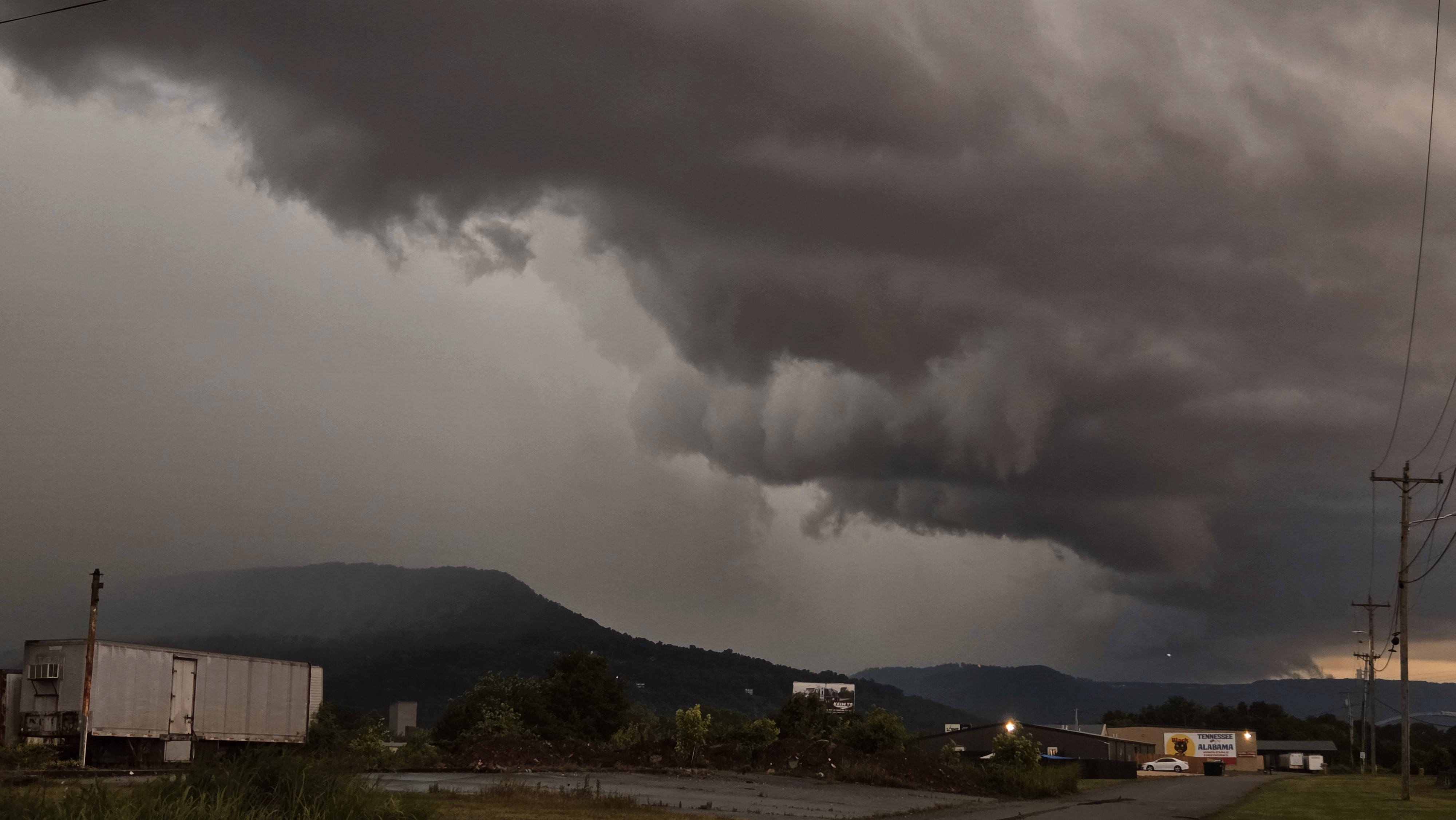
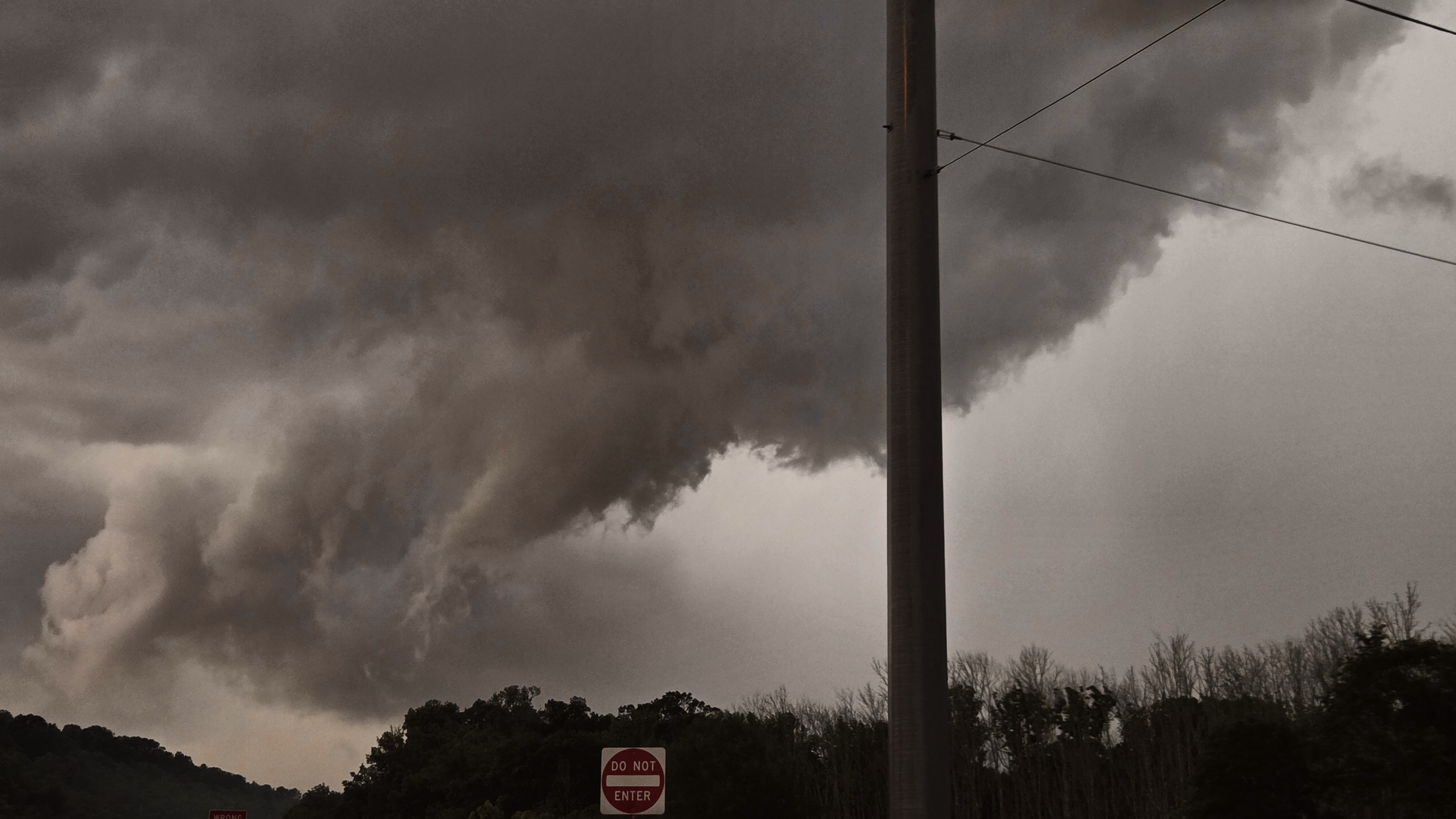
Unfortunately lots of scattered but significant damage is reported in North Alamba. James Spann posted. Also saw text reports from EMs. Sad deal more like an April event. Haven't heard much from the Nashville 'burbs. Meanwhile sups split Chattanooga so we lucked out here. I was unable to truly chase on Tuesday due to work requirements. However during a lull between the Cherokee, AL / Pickwick Reservoir tornado and evening trouble I was able to get out locally. A severe warned cell (actually the Cherokee cell hours later) tracked from Monteagle, to Dunlap, to Soddy Daisy all Tennessee. I-24 is a no-fly zone for me at rush hour, so no Monteagle, but I was able to track it from Dunlap to Soddy just north of Chattanooga. It was between 6-7 pm EDT before the Madison, AL and Huntsville stuff got really ugly. Here are my low-lights. While the first is arguably structure out of the spotter's guide, less crisp but good for East Tenn... the rest is scuddy crap. Oh well! At least I got out of the house. So while the Cherokee cell stopped producing tornadoes, it retained supercell characteristics for several hours. I believe it was on the intersection of the outflow boundary and a prefrontal trough. Evening cells were associated more with the main surface trough - enhanced by the same outflow boundary.