nrgjeff
-
Posts
4,251 -
Joined
-
Last visited
Content Type
Profiles
Blogs
Forums
American Weather
Media Demo
Store
Gallery
Everything posted by nrgjeff
-
Bah Humbug! This fits better in severe than general December, where we have one more clipper / frontogenesis north of I-40. Warm themes could lead to severe. Please don't share commercial, but it's not a huge surprise. Everyone can see the weekly models. Straight North American pattern recognition.. forget all the teleconnections TCs.. Pineapple Express ends mild downstream. Current Pac NW firehose is why our Sunday cold front will be history by Tuesday afternoon. But the TCs are going to the dogs too. North Pac ridge going to the Aleutians not eastern Alaska. -PNA +EPO torch regardless of the WPO. Guess Jax and I are going to end up chasing the OV Midwest.
-

December 2025 Short/Medium Range Forecast Thread
nrgjeff replied to John1122's topic in Tennessee Valley
Snow for Hanukkah. Severe for Christmas. Checks out! Getting off my torch horse.. The following teleconnections reveal something like the chart below Days 16-20 which is Christmas and the following weekend. Maybe delay to New Year. Maybe the other way, shallow cold airmass brings a colder verification in Tennessee. Who knows? Cold air supply in Canada MJO tracking back through 7-8 colder phases WPO ride still rex blocking North Pac, if we can boot any Alaska trough Strato is still active / warm Do not share for any commercial purposes. This was posted yesterday afternoon, so I feel like it's OK to share just here.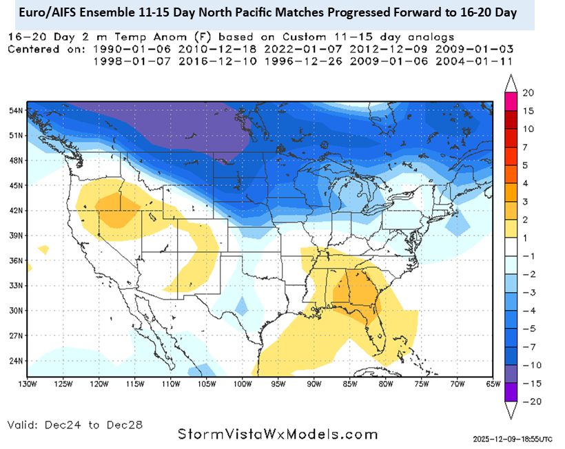
-
December 2025 Short/Medium Range Forecast Thread
nrgjeff replied to John1122's topic in Tennessee Valley
This system will probably do more than Monday night Tennessee north of I-40. Not everywhere, but more places esp northeast Tenn. More I mean snow. Fortunately the ice looks trace again. Regrettably I don't have time to write more. Good luck up there! -
Fall/Winter Banter - Football, Basketball, Snowball?
nrgjeff replied to John1122's topic in Tennessee Valley
I have Tennessee to win the SEC. I think it's regular season, that's what I intended lol! Lots of tough teams in the SEC. It's gonna be a fun season. However I'm not buying Florida or Kentucky. Tennessee has as good a chance (or better) than anyone. Big 12 Houston will probably live up to the hype. I'm not expecting much from Kansas. No conference title is considered a failed season. -
December 2025 Short/Medium Range Forecast Thread
nrgjeff replied to John1122's topic in Tennessee Valley
Ope! Two more posts came in while I was deliberating. RAP looks juicier. Otherwise my sports malaise creeps into weather... Thursday night looks similar to Monday night. Little bit of ice (trace) northwest of I-40 in the Mid-South. Light snow north of that, but probably less for northern Kentucky. Any light mix or ice area will get slick roads. Not enough QPF to mess with trees and power lines. Let's keep those themes all winter! Wake me up with Chattanooga can get below 40 deg during precip. January? Ah hell, let me get back into the severe thread and chew on Jag's post. That's what I'm talkin' about! Chatty rants aside, the cold pattern seems to want to stick around longer than initially forecast. While the MJO wants to complicate things, colder teleconnections are forecast to win out (on models). Even as the pattern relaxes (only somewhat) day 11-15 a possible reload awaits the weekend of Dec. 19 or going into the week of Dec. 22 which we'll call the 16-20 day. I'll throw in some gems from the Physical Science Lab. Keep that comin'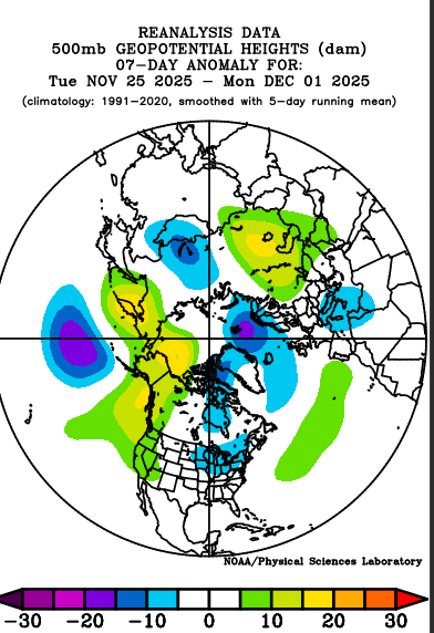
-
Fall/Winter Banter - Football, Basketball, Snowball?
nrgjeff replied to John1122's topic in Tennessee Valley
Good grief both Tennessee and Kansas lost last night. Tennessee almost caught 'Cuse multiple times - like stranding baserunners. Kansas simply had a blown save - arguably the most frustrating thing in all of sports. Indeed, the most frustrating thing in all of meteorology is cold air in place and the system goes south. Truly PUKE inducing! -
Fall/Winter Banter - Football, Basketball, Snowball?
nrgjeff replied to John1122's topic in Tennessee Valley
Thank you @Carvers Gap and @John1122 I thoroughly enjoyed the game because I really like Tennessee too. Unfortunately only one can win. Frankly we should have been the championship game. Gonzaga? Then Michigan is just annoying! Kansas lost to Duke in Chicago and UNC there. KU may have righted the ship now. Tennessee looks good. They probably got tired 3rd day in a row with Houston in the mix too. I like Tennessee in the SEC! Happy Thanksgiving y'all! -
December 2025 Short/Medium Range Forecast Thread
nrgjeff replied to John1122's topic in Tennessee Valley
Deterministic models are pure chaos. Ensembles are flopping around but one can at least find some reasoning for that. After the Thanking cold a brief warmer episode is likely because of a little -PNA. However the Alaska ridge persists, so warmth probably won't. In fact by day 15 the EPS and somewhat GEFS hint at cross polar flow. Some support for return to cold mid-December, and perhaps lasting, comes from a retrograding Rossby wave. Since that's a 500mb feature we don't need to debate the SSW. Strato heights are well AN and want to reflect at 500mb. While I don't believe SSW wrecks cold patterns, it doesn't always favor North America. SSW signal is best for Eurasia. Things like the Rossby wave can turn odds for North America. The weekly charts may be picking up on all this. They go with the warmer week before settling into a colder regime with less back and forth. We'll see. Stuff changes every day. Who knows if all the background forecasts verify? At least the results make some sense this afternoon. -
December 2025 Short/Medium Range Forecast Thread
nrgjeff replied to John1122's topic in Tennessee Valley
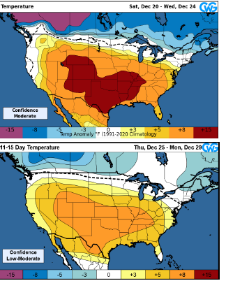
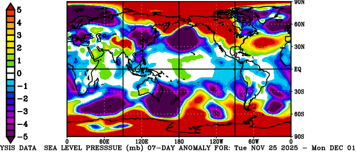
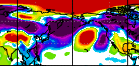
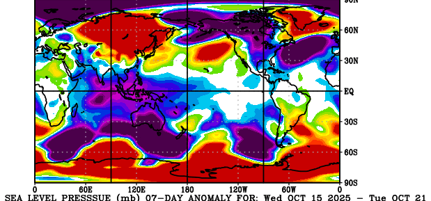
Glad 2005-06 came up. December got nutty cold. Snow blanketed much of the country. Then it got warm. December cold broke around Christmas in KCMO, which was a little disappointing. January thaw was torch. For this year, operational models are of course all over the place. Thanksgiving weekend cold front CF may actually be faster on Thanksgiving rather than the weekend. Then a few milder days are forecast before the next CF. Weekly products the CFS gets cold established for the first week of Dec, fading during the second week of Dec. The ECMWF weekly doesn't seem to acknowledge the Thanksgiving weekend CF but starts the cold west to east trek the first weekend of Dec. Putting it all together, I think the first 1-2 fronts could be brief cold intrusions. Thanksgiving weekend and then middle of the first week or weekend of December. ECMWF weekly struggles to discern the fronts that week. CFS may lock in cold a week early. Perhaps after a couple fronts chip away at the warm pattern, by December 10 give or take a couple weeks can average truly below normal temps. See if we could get that through Christmas for a third week. Siberia continues to set the table.. for after we work through the North America warm week to 10 days. Temperature anomalies, blue is cold Sfc Press anomalies, red is higher
-
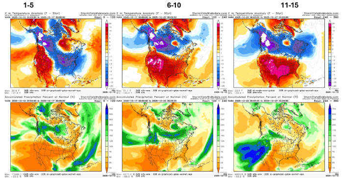
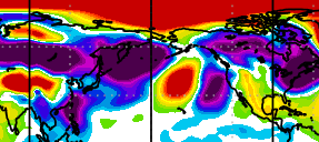
Most ensembles have cold in here by the weekend after Thanksgiving. EPS is slowest end of that weekend. Some AI versions have it by Black Friday. Weekly products have the cold pattern lasting 2-3 weeks now, a marked change from the quick hit shown last week. Strato situation is trying to reflect at 500 mb which is also a cold signal. MJO actually comes around about Dec 1st, but will then line up with other signals for cold. Check of the Physical Science Lab PSL Map Room: Global Circulation (Quick Menu): NOAA Physical Sciences Laboratory shows the table being set after we get past the warm North America (here late week, early next week). True Arctic surface press is quite high. Part of Siberia is getting cold north of the Kazakhstan warmth. Eventually we'll look for higher pressure into Siberia from the Arctic, and for it to get into more of Alaska. Note a small cold patch is already in western AK. 7-day surface press anomaly red is high 7-day temp anomaly blue is cold
-
The SER can probably arrange that. I should be careful about what I joke. Edit: latest ensembles are slower. Otherwise a bird in the hand sooner is always nice. If we get a Jan. thaw maybe February gives a winter encore. Kind of the Carvers Cossgrove hybrid winter. While La Nina is notorious for west first SER, the hemispheric pattern variability should deliver bouts of cold to the Southeast too.
-
Just today the CFS and GEFS weeklies join the colder forecast for December. ECMWF weekly had been consistent which added confidence even before others joined the chorus. Agree it will take about a week (2nd or 3rd front) to chip away at the SER that builds next week through early Thanksgiving week. CFS and extrapolating mid-range ensembles points to right after Thanksgiving. Same for some AI stuff. GEFS and ECMWF weeklies are slower more like 1 Dec. While the MJO promotes the slower timing, a Strato warming event could promote the faster timing. SSW is normally the slower process but it's already in progress. MJO has to tee up the warmer phases first. Physical Science Lab Asia pressure and temps has not really set up yet, no surprise with the MJO. North America has a ways to go. Eastern Siberia shows very early signs. Rest of Russia and China no signal (bearish or bullish) so overall those charts are not set up yet. PS @Carvers Gapyou'd prolly love this site given your post about pressure / temps on the winter spec. Maps won't load for me, so maybe you're already looking there. PSL Map Room: Global Circulation (Quick Menu): NOAA Physical Sciences Laboratory
-
Fall/Winter Banter - Football, Basketball, Snowball?
nrgjeff replied to John1122's topic in Tennessee Valley
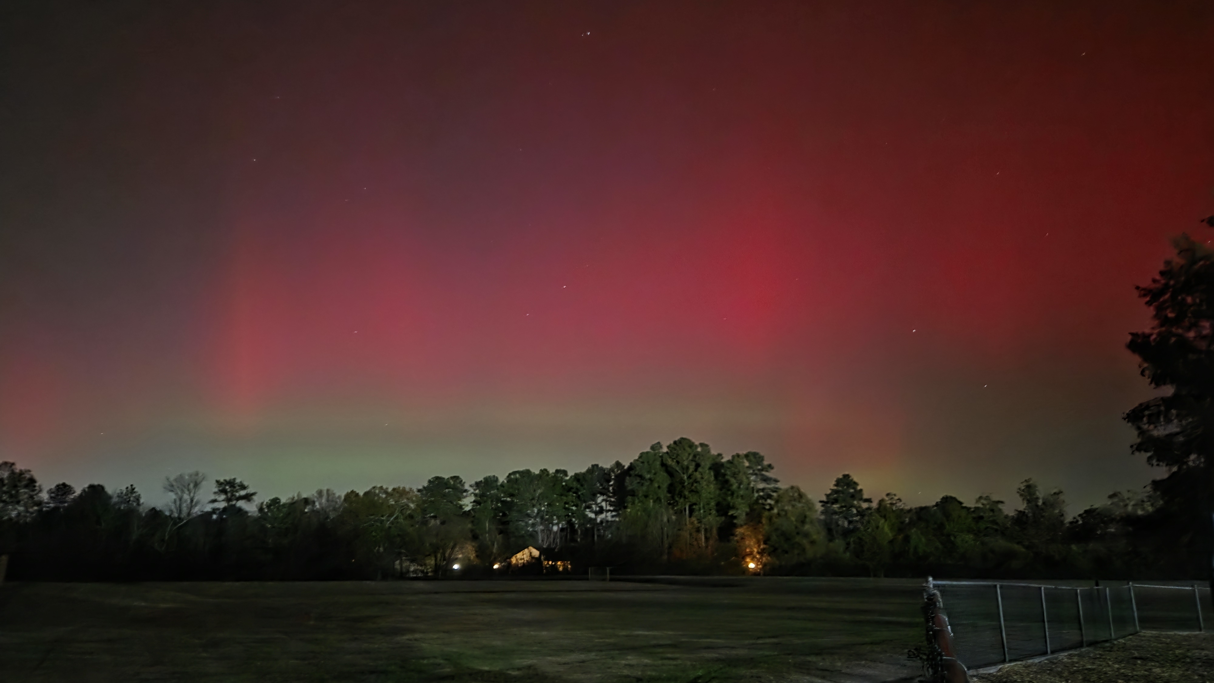
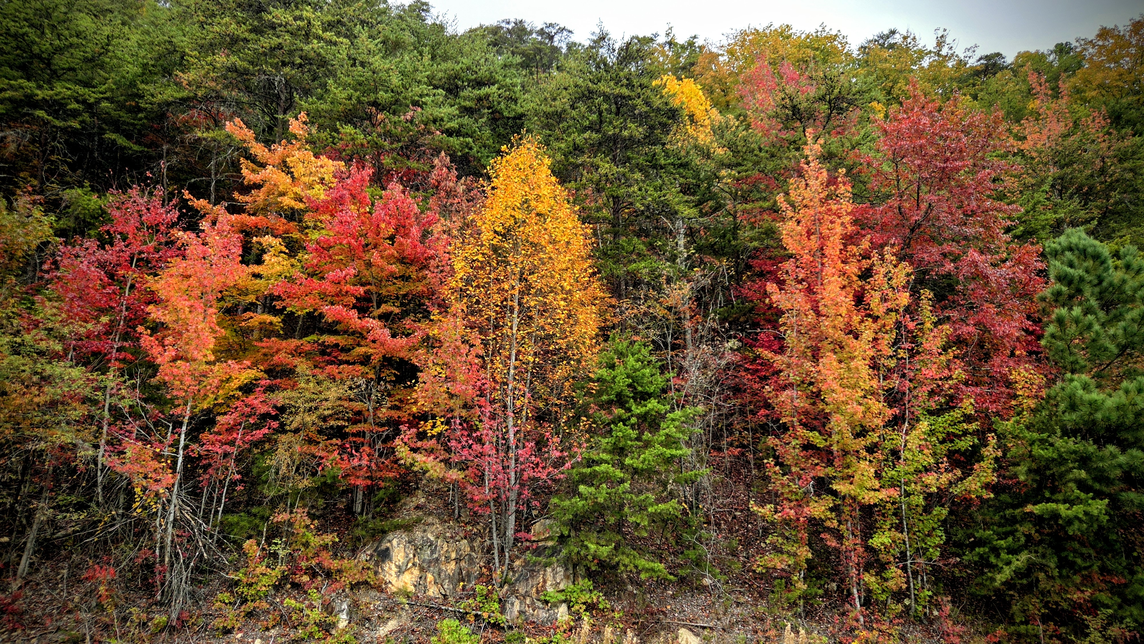
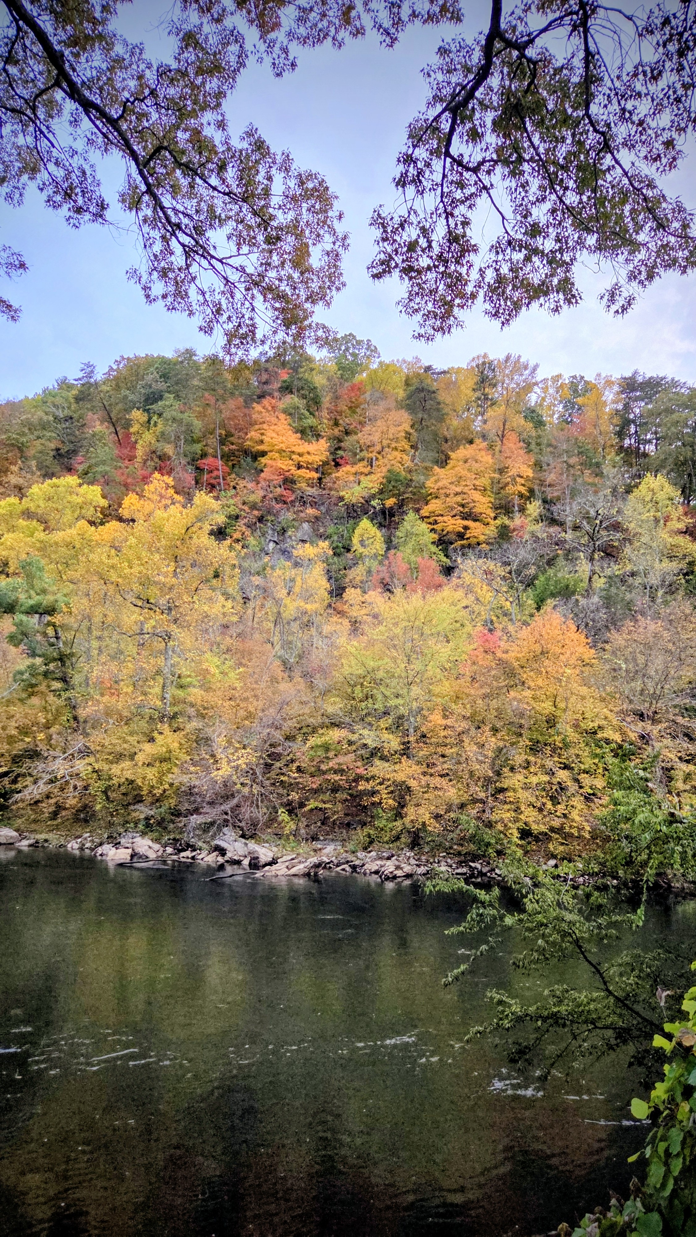
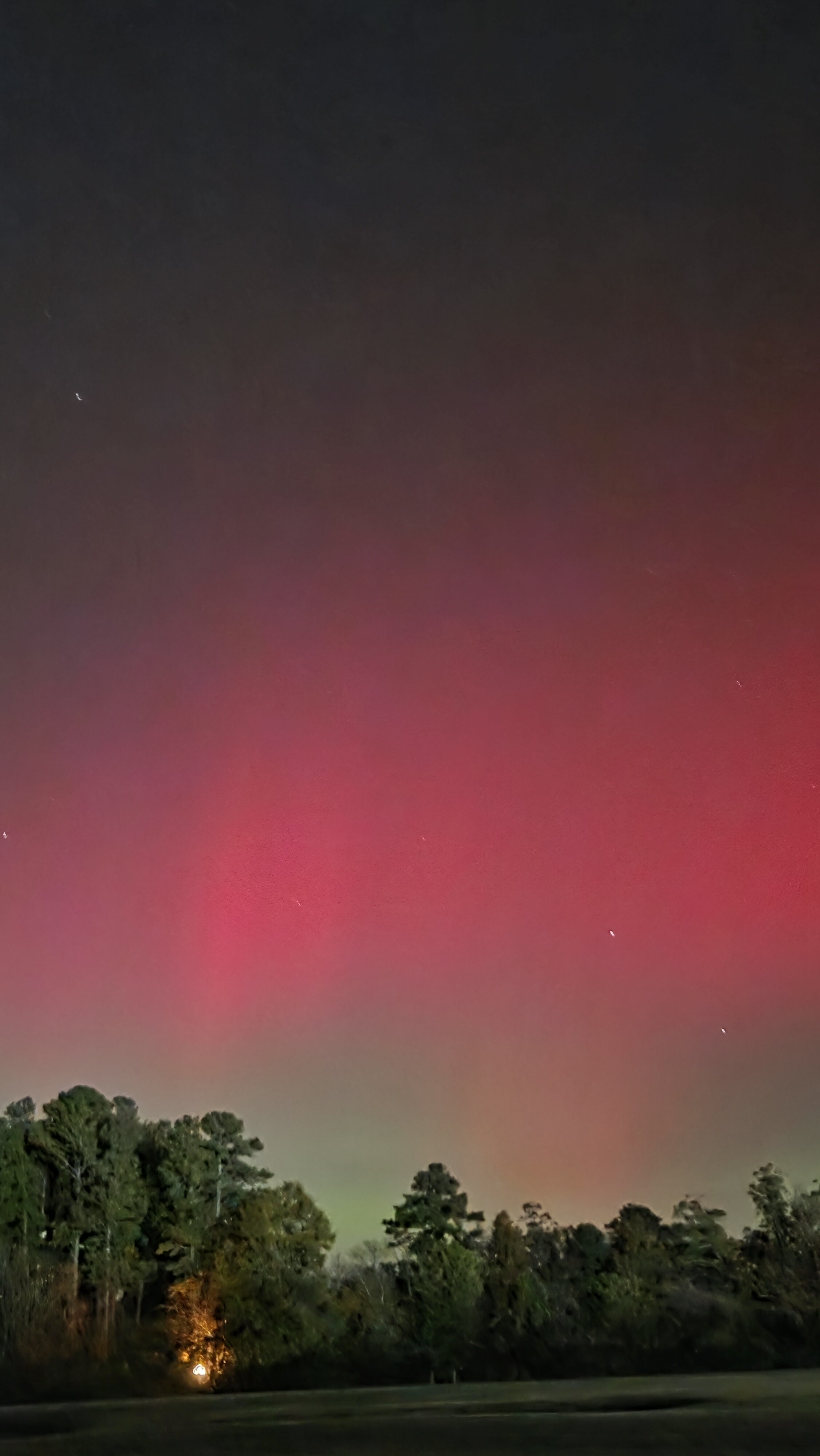
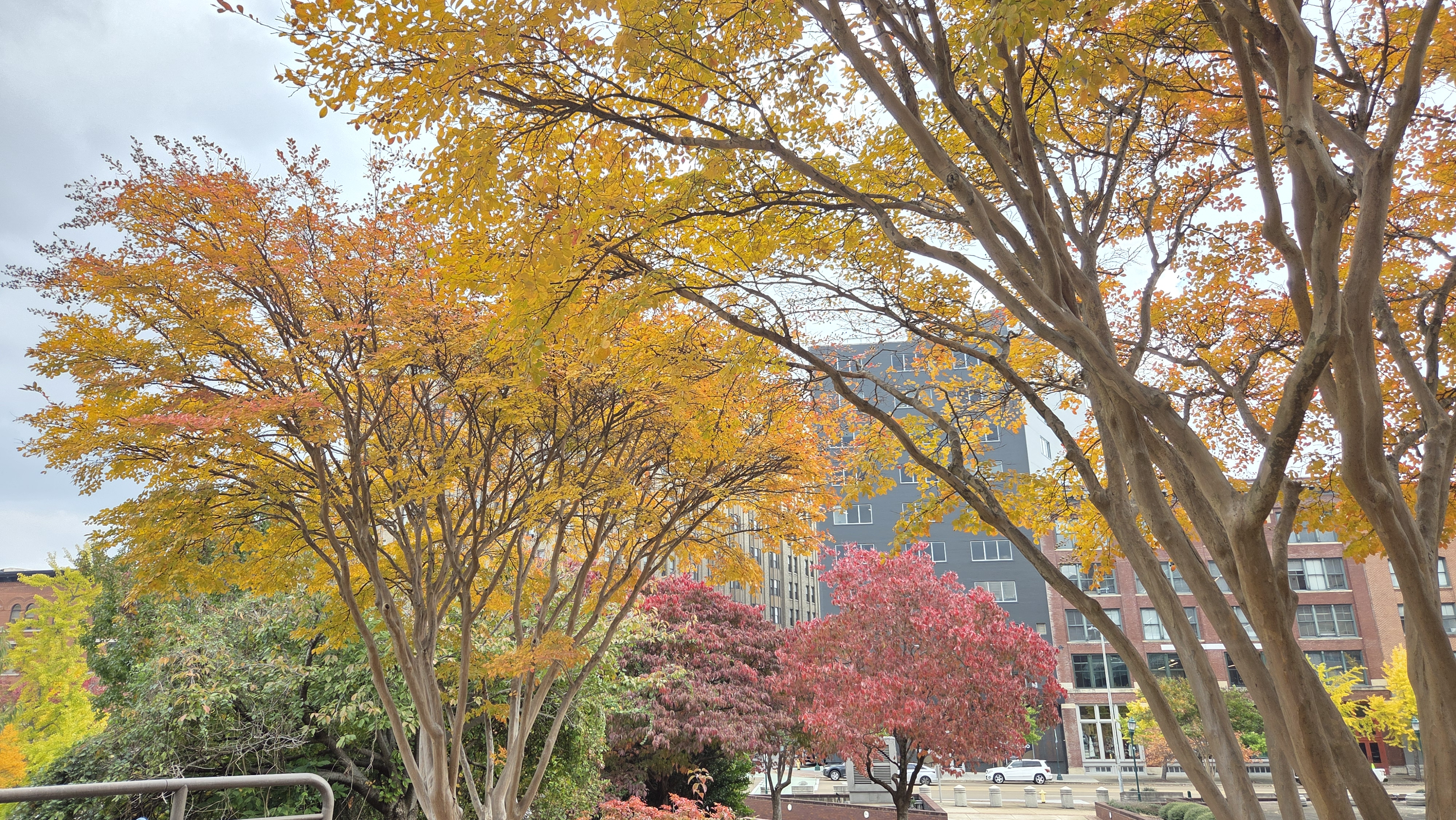
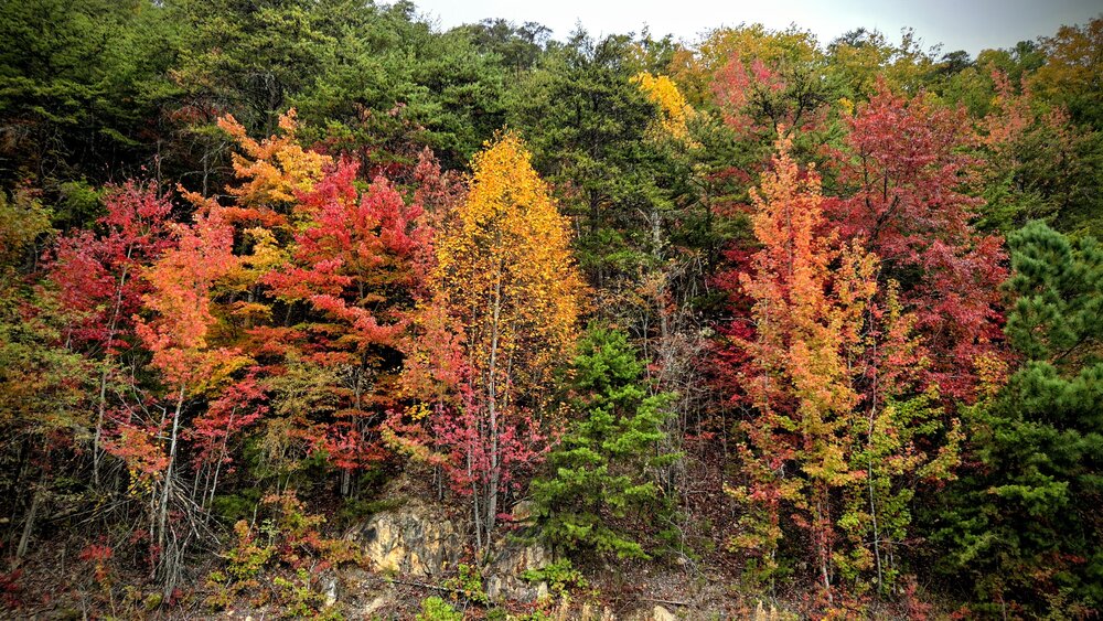
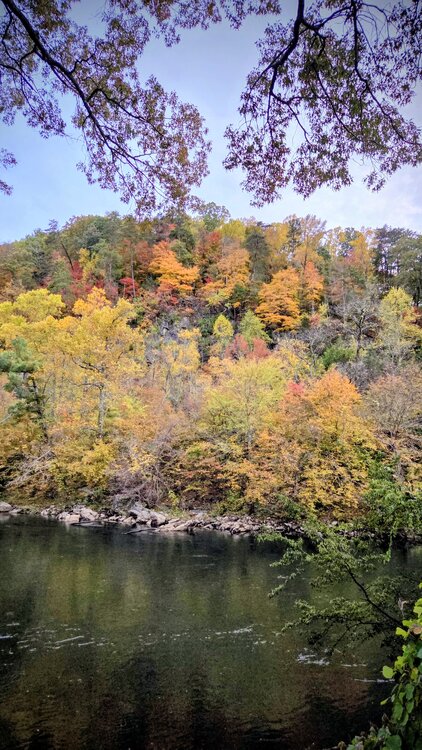
Here is my take from Tuesday night. Northern Lights display for Southern Veterans! Then some fall foliage highlights from Ocoee a couple weeks ago.. And downtown Chattanooga showing off last week. Finally vertical bonus photos. Quite a colorful fall!


-
Maybe so. Getting close to a thread worthy event maybe short-term forecast and obs combo thread. Might not need two for this one though. Thank you for all the ground truth! Fun to see how everyone is doing and I find it useful for work too. Indeed another short wave is coming in behind for this afternoon. Bubbly satellite loops show it coming out of Kentucky. Plateau and Mountains should continue going. Maybe some Great Valley North. I don't expect much in Chatty. Still I'm happy for y'all and will enjoy it vicariously.
-
Strato is active but might struggle to reflect to the 500 mb for a bit longer. For now we can enjoy the cold snap early next week. Even if it does get mild again, my gut says more cold beginning of Dec. Snow cover is increasing again on the Rutgers chart after a pause. Physical Sciences Lab checks out for Siberia, China, Alaska pressure and temps. Nothing screams like what I shared a couple weeks ago, but it's leaning the right (cool / cold) direction. At least I don't discern warm torchy signals there. PSL Map Room: Global Circulation (Quick Menu): NOAA Physical Sciences Laboratory charts update despite the red banner top. Prolly automated.
-
Fall/Winter Banter - Football, Basketball, Snowball?
nrgjeff replied to John1122's topic in Tennessee Valley
Kansas at North Carolina tonight. Football season pauses until Saturday. This Friday night lights, we shoot hoops! -
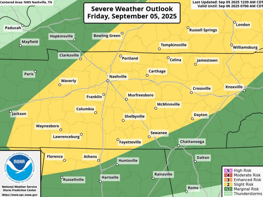
Here we go. NexLab updates before SPC. Free for All Friday!
-
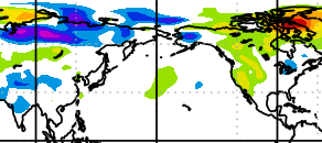
Apparently the Physical Science Lab is updating charts. Maybe they are automated. Red banner (no updates) might refer to articles and the like. Snow cover (not shown, see Rutgers) in Siberia and East Asia is running above normal as noted in previous posts this thread. Mongolia snow is building. If it was stormy low pressure that would not be particularly bullish. However - good for snow fans - Siberia surface pressure is way up (Chart is below). Press is lower in far eastern Russia into the Aleutians; however, that's an overall strong high press signature for Siberia. Temps (not shown) are below normal Mongolia to Manchuria and normal up in the Siberian high (also cold). It is a good signature for the snow cover too. If one wants a cold North America later, one wants Siberia high press (not stormy) and colder temps into China (not locked north). SSTs are already well covered earlier in this topic / thread. I still favor a slightly mild winter for our Region from the Mid-South to the Valley, but that's colder than recent years. Gulf Coast warmth (La Nina) should spread up here occasionally. Colder Midwest air could / should get in here a few times, esp if the above background state holds.
-
Two to three weeks, maybe more, may average cooler than normal now. Models are pretty consistent. Appears that some western North America ridging is somewhat anchored by a trough in far eastern Siberia and the western Aleutians. Related to the East Asia pattern, Siberia and Mongolia snow is running at/above normal per Rutgers snow map. Unfortunately, my observed / historical pressure anomaly charts for the last 7 and 30 days is not updating with the gov shut-down. NOAA Physical Sciences Lab is not immediate forecasts like most NWS sites that update. Without recent history pressure I can't put the snow cover into context. Hence, I post in the fall thread rather than winter. SST discussion in the winter thread is good though. EDIT: Charts do update on the site above. Winter thread time! In night sky news I saw Comet Lemmon Wednesday pretty clearly through binoculars. Could not make it to darker sky Tuesday when it was closest to Earth, but another observer said Wednesday was just as good. First try Sun/Mon was inconclusive. Anyway tonight Thursday may be the last chance before greater cloud coverage and / or moon.
-
Fall/Winter Banter - Football, Basketball, Snowball?
nrgjeff replied to John1122's topic in Tennessee Valley
Seems like Tennessee is back on track. Come from behind on the road in a conference game is always a big W. Elsewhere in the SEC I think Alabama has righted their ship. Georgia should still be fine though. Ole Miss should get a big ranking boost. In pro we Chiefs fans can breathe a little easier. L. Jackson was in for 3Q so Baltimore what a good test. D has improved significantly. Offense may be finding its form, though Ravens D gave up a lot to Buffalo too. Do you know what's really crazy? Late Night for basketball programs is just around the corner. Overlap of college sports is the most wonderful time of the year! -
This discussion is hawt! I'd like all the posts but then I'd run out of reactions for the day. Yeah the QBO trending down is important. I'm not a subscriber to buried negative in autumn. Give me the down trend. Rate of change could be far more useful than a deep negative snapshot. Siberian snow I also prefer a corollary over just the coverage anomaly. Why is coverage AN? A stormy start to the season drops a lot of snow, but might not be the path to -AO. A COLD start up there with high press, snow driven by temps not stormy, might be better for an eventual -AO. PSL Map Room: Global Circulation (Quick Menu): NOAA Physical Sciences Laboratory is where I go to look. Unfortunately I see BN surface pressure in Siberia. I prefer AN Siberia with lower mean press in China. Ditto temp anomalies; I'd prefer they trade places. I use words like could be, might be for the QBO and Siberian Snow because neither has as solid a track record as was advertised 15 years ago. I still think they are useful as one tool in the tool belt. I also write from the good/bad perspective of want Southeast snow. The PDO could promote +PNA episodes which are cold in the Southeast. Wavelength matters though. And we need the WPO to cooperate with the EPO; otherwise, congratulations Great Plains! All that said, source region matters. 10 year trend matters. I lean mild for winter. However I don't have the torchy vibes I've had several recent winter forecasts. We may in the battle zone between temp regimes.
-
Well hopefully this is our last warm spell. I've been off the board for a while, but all is well. With tropical cyclones staying offshore it allows warmth through the middle of the week. Still might get some Mountain t-storms. I'm hoping for some Tropical high clouds Monday evening to set up a gorgeous sunset but that might be only a Carolina thing. Looks like some new members, or back after a while. Woo-hoo! Welcome @midwoodianand @louise.caison233to the best Region on the Forum. Yeah Signal Mountain forecasting is a whole other animal. Slips under the model radar, yet big enough to make an impact. Then there's the ol' 2 inches of snow on Signal with lovely brown ground in the Valley! Somebody asked me about fall foliage, about which I have no clue but somehow I always make a guess. My thinking is the August rain saved southeast Tennessee from a dull autumn. Northeast Tennessee seems to find a way no matter what. Elsewhere might have drought stress from July and August. Recent dry is less of an issue since trees start to go to sleep even while they're still green in Sept. However it goes the other way; recent Sept. rain might not help much. We'll see. Fall foliage is like a box of chocolates!
-
Yeah if winter is going to be warm, might as well tee up a severe wx buffet line! The monthly charts are hideous for snow. SER might be overdone. Surface cold might do better than progged. However the precip charts (AN Mid South) scream cutters.. and severe! for Snow I prefer AN precip to my south (the rain). low Liquid content snow should be near normal north of the rain. Even BN qpf can work for snow in colder regimes. AN qpf is almost always rain. Should I move that last paragraph to winter topic? Nah, because I don't think it'll actually be that bad. North Pac is warm. Here I'm just jawboning severe.
-
Looks hot the next two weeks through maybe Wed. Sept. 25 but mercifully humidity should be low to moderate. Only drawback with low RH is the drought will get worse in the Mid-South and western half of our region. Drought might even spread east. Not as hot east, but still dry. -GLAAM favors the warm pattern. While the ECMWF weekly is warm forever (what's new?) the CFS drops a Great Lakes trough at the end of the month, somewhat helped by a slight +PNA. Even with the GLAAM situation even a slightly +PNA can allow the said trough. CFS makes sense to get our region's temps back to normal. Euro weekly has a similar 500 mb pattern with a Midwest trough. It's west of the CFS trough axis; so, the Euro keeps the Southeast warm. Gonna have to disagree though. With normal heights, surface cool fronts should make it. Sure it'll be a day later than progged, but FROPA will happen. Bottom line: I have to go with the CFS milder late Sept. Hard spot: I figure drought could expand east more than CPC shows. We'll see. Little NW flow surprises like today might mitigate such a thing.
-
See if we can tee up some more super structures today.. or just be an after thought relative to Thursday. I always like the Upper Plateau. Just a bit more upper level wind support per SPC text, plus the topography.