nrgjeff
-
Posts
4,261 -
Joined
-
Last visited
Content Type
Profiles
Blogs
Forums
American Weather
Media Demo
Store
Gallery
Everything posted by nrgjeff
-
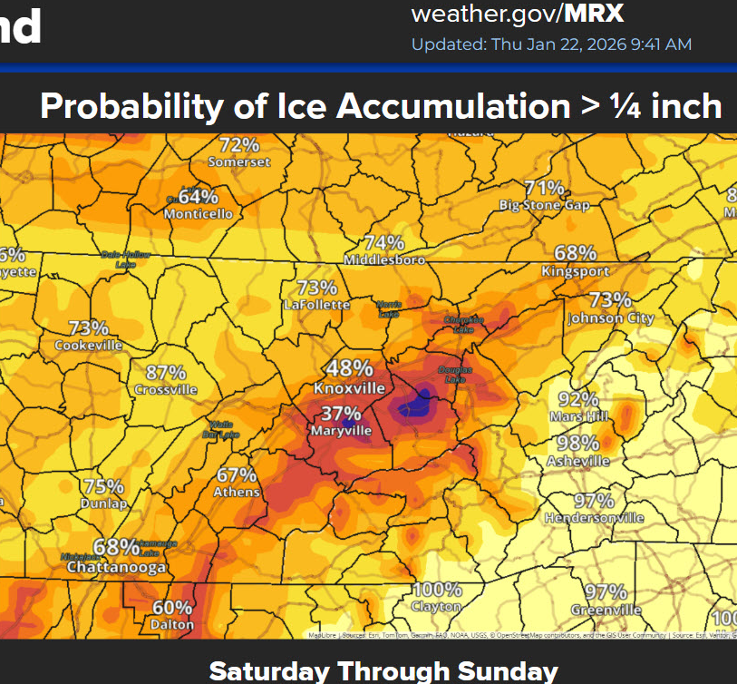
Bless BAMS heart, there is no chance of an inch of ice in Chattanooga proper. Signal might get a half inch if they stay below freezing, but that's clickbait in town. Human should have QC'd it. Obviously it's the Mountain, but it seems a bit much even there. Downtown to East Brainerd, I have basically no concern about life. Yeah prolly some power outages Sat. Hopefully not my house. Roads should break up on Sunday.
-
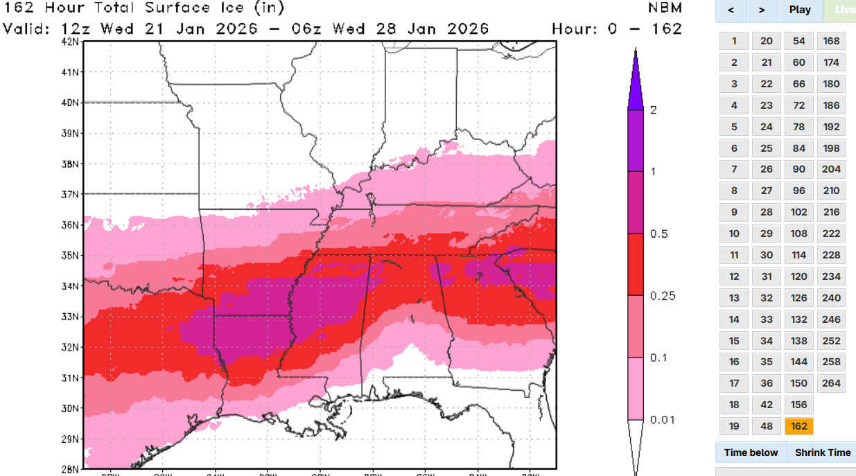
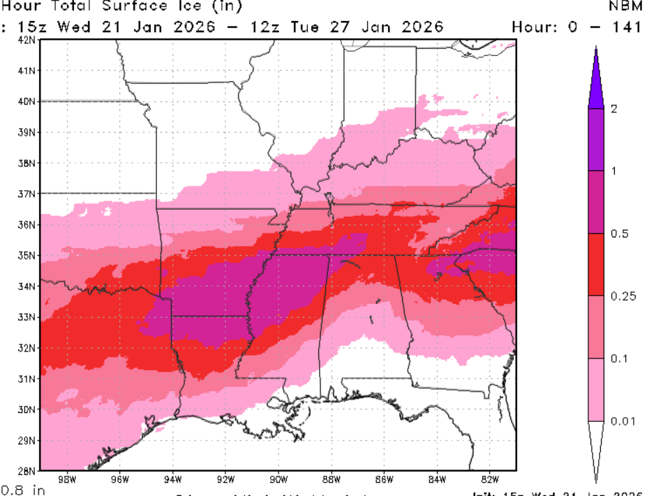
HRRR is doing that also Mid-South to Mid-Tenn. If that MEM forecast sleet manifests itself at FZRA they are looking at 1994. Some of the rest of North Mississippi is Quebec 1998. OK I'm out. Work intensity rivals that leading up to 4/27/11.
-
It needs to cut like the 12Z GFS. Hammers Chatty all snow Day whatever that is.
-
Been up since this morning. I missed it on the Public page. Looks considerably better than some of the lighter (blowtorch) charts I've seen. Mostly lines up with national WPC stuff too. I'd still back off for KCHA (use those lower charts) but I like this one points northeast in the Great Valley. Crazy downslope still shows in the foothills, while keeping the other side of the Valley locked. And those elevations are in the warm layer.

-
Yeah the early charts were a little light on snow and ice for northeast Tenn. Euro is in line with the national charts from WPC. MRX will update accordingly. I still feel relatively safe in Chattanooga. I see trouble from Knoxville northeast. Relative in Chattanooga means some ice but not crushing. Knox to TRI needs to watch that cold lock more. Separately, lol I was just kidding about the AI. Guess it's so.
-
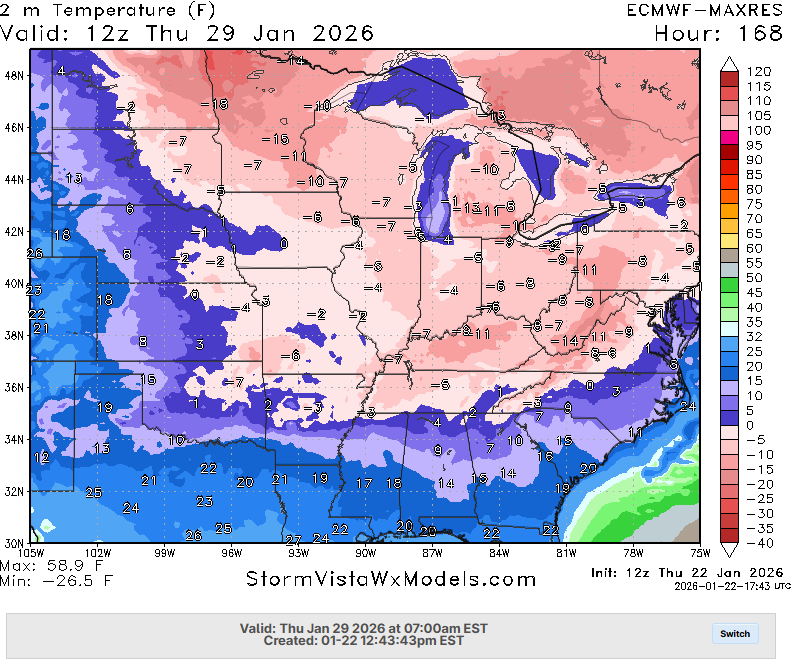
This would be a huge problem across the entire Eastern Interconnect. Temps go all the way to the Coast from NYC to New England. GFS (not shown) has a gem of a Miller A very end of January.
-

Fall/Winter Banter - Football, Basketball, Snowball?
nrgjeff replied to John1122's topic in Tennessee Valley
Well this did start out as a heavy rain outlook on the CPC 8-14 day And now we have CAPE and some shear in South Bama on Sunday. -
AI read your posts on the Internet. OK I'll let @Scottie16 answer for real.
-
Duration of extreme cold for areas without power and heat will be concerning. Mid-South to perhaps Mid-Tennessee are at risk. Then Mississippi is a whole other level of ice storm forecast.
-
Sweetwater could be that line in the sand for the Great Valley. I'm pretty sure the warm nose wins south of there. Sweetwater and Athens are a slightly elevated area relative to CHA and TYS. Could be less certain north of there. Chattanooga local notes: Signal, Lookout, and Flatop are not going to get as warm as KCHA. Could stay <32 deg for the duration. They are all still locked in for Warning criteria ice. Downtown to maybe East Brainerd, I'm much less concerned - except Saturday. Then Sunday may cut.
-
Pattern recognition is why I'm standing down Chattanooga. Yeah we'll get 1/10 to 1/4 inch ice, and hit Warning criteria, but that's not crippling at all. Yeah I see the ICON wrap around the CAD, but even it eventually breaks for CHA. That can happen in spring to crush severe wx chances. Winter the warm nose usually wins out for Chatty. Even the GFS brings into CHA >32 deg. NBM and other ensembles are modest to moderate ice here. They all drop the Quebec hammer on the Mid South. Memphis to Nashville are a 50 mi path jog or sounding change away from major impacts too. Finally the ol' 1/3 of liquid QPF (during sub-freezing temps) still works to forecast ice accretion. Checks out all of the above.
-
Memphis just dropped the hammer in their EM briefing. I don't think it's public for North Mississippi ice totals. So I'll just share a Quebec flag (1998 ice storm). If this comes even close to verifying, you're reading my last post of the event. due to work. I believe things in Chattanooga will not get too bad. Mid South though, is going to be Hoth.
-
Oh goodness that's right! He was fading the South and cold. Well I think natural gas already crushed him if he's short. Storm track might be another story, but it won't fix their trading account.
-
Chattanooga exit ramp is regular rain. Sure as hell isn't snow with these trends. NBM, EC and implied Euro AI is now less ice in Chatty. Looking at above freezing temps during the heaviest QPF. I'm looking hard locally for personal and work staffing decision. Now, the rest of work by way of the rest of the service territory, looks pretty awful somewhere. Worst areas will be determined by lack of sleet (all FZRA) and of course QPF under the ice soundings. Some of Tenn could get some help from sleet. North Mississippi ice is lookin' rough. I will log off before 00Z runs arrive. Might be up but I'll be watching basketball. Thursday morning I hope to add a last post. From there work will escalate.
-
AIFS / Euro AI doesn't have a direct ice chart, but here is what I discern from QPF and time the sounding is ice for KCHA. Might start as sleet but goes FZRA pretty quickly. Through Saturday night 1 to 1.5 inches QPF is over 1/3 inch ice and possibly a half inch ice accretion here. Anything greater than that (and it's definitely on the table) gets historic. Points to my northwest (Middle Tenn not necessary BNA) have over 2 inches of liquid rain locally 2.5. Some of that has to come as sleet. Still could be well over a half inch of FZRA with plenty of 3/4 inch reports. Question above, @WinterWonderland yeah the NAM is probably too far north. Euro path is stubborn though, and the GFS is trending that way. The jogs are usually 4-5 days out. We are within 3 days. Ice invasion is imminent.
-
Ukie convection. More of that please! We just need a severe outlook to go with everything. I kid of course. If the Euro starts doing things like that this will get more complicated. My guess is models are trying to figure out the two waves. Stay the course, which is unfortunately icy awful.
-
Some of y'all on I-40 could get bailed out by sleet vs several hours of freezing rain. We'll see. Problem farther south is that the warm nose is strong and thick; so, that's freezing rain.
-
NAM cuts and blasts the warm nose. Anyone surprised? Punt that still 60-84 hour fcst. Euro seems too amped too. GFS is too optimistic for snow lovers though. I am afraid the middle ground will verify. In this case the middle ground is bad because it's lots of ice. Personally, I've experienced only two ice storms as bad as what's forecast. One was right in the middle of it 1984. Other was forecasting 2004. A once in 20-year event is possible. Guess what else moved north. Selfish solution for Chattanooga: Punt snow wishes and reel in all rain. However that would be a devastating ice storm for just about all the rest of this Region.
-
Speaking of the NBM, it keeps spitting out crippling ice forecasts. Its snow is robust north of there, but more like a foot than these 18-24 inch forecasts. Ensemble could dampen out the heaviest snow band, so there's upside. Just this ice. wow once in 20 years.

-
Easy to post clickbait out of market. They'd be held accountable in market. Though speaking of model consistency, there was a storm a long time ago modeled a week out.. Even with those much less advanced weather models. March 1993. Let's NOT do that again though, and hell no to the ice version!
-
Models lost the Jan 29 storm. Hints are there around Feb 1. Maybe they'll find that Miller A again. Weeklies look cold most of Feb. -AO is noted but Europe will get a break. Fine, we'll take it over here. Just not ice!
-
Those few hours of 700 mb and 850 mb at/above freezing, but only by a degree or so, spells sleet not freezing rain. Partial thickness charts also show the shenanigans. Fine line between staying sleet, and a half inch of freezing rain. I wonder how amped the NAM will be when it comes in range. Prolly Quebec us. Let's hope the Euro trends colder for snow.
-
Those ice amounts check out with the ol' school divide liquid QPF by 3. It would be devasting. MEM ice probs in Mississippi are 33%+ of a HALF inch which is quite high for Day 5. BNA has high six-inch snow probs. That's what I'd rather see. Model agreement on this promotes such bullish NWS comms.
-
Yup! TVA sent big transmission line crews to help with the distribution system. Some of these models is that, but over a much wider area. I remember Chatty snow a year ago had ice questions, but I think more than one model had the more snow solution. Need to see that Wednesday, Thursday at the latest - or it's game over.
-
Yeah the Valley warm nose in the last 15 years rescues Chattanooga (above freezing) but might ice Knox. This one the cold is too deep. If the mid levels stay warm, Chatty's luck has ended. Then the Upper Plateau has that same risk. Instead of elevation helping with snow, it only adds to the cold vs the Lower Valley. Then both are warm aloft. I would like to see one other model besides the GFS get less ice. For now, weekend concerns continue to mount.