nrgjeff
-
Posts
4,251 -
Joined
-
Last visited
Content Type
Profiles
Blogs
Forums
American Weather
Media Demo
Store
Gallery
Everything posted by nrgjeff
-
That could happen if we get a Rockies trough and Mid Atlantic ridge. All 3 major weekly products have AN heights in the Mid Atlantic, but normal out West. Would be enough if a system or two pass through that flow. Until then I don't see much exciting. Might get wind/hail outlooks (like Day 3 Sunday from Friday) but the WNW flow should keep tornado outlooks in check for 10+ days. We'll see what April brings.
-
Hey @jaxjagman I have no idea. How was the wind at your location? UPDATE to my posts: UAH sounding shows about half the forecast 0-1 km shear. Time to check the college basketball schedule.
-
Surface temps are pushing 80 which primes the Valley. Storms coming in from Middle Tennessee have meant business. We'll see how they hold across the Plateau. Not much action yet in North Mississippi. I believe it's a local area of subsidence (or at least less rising) in the wake of the Tennessee stuff. Another upper wave lurks, making quick progress from the Ark-La-Tex. Good thing the low levels are veered off all crazy. If those winds were backed and/or had better convergence on a mesoscale boundary it'd be trouble. As it is, just the synoptic front and its orientation should favor mainly straight-line wind. The hatched 2% remains valid and legit. Still this is mainly gonna be straight wind. No chase plans.
-
SPC site is slow. Anything going on? Couple models juice up the southern stream and get cells going ahead of the line in MS/AL. Otherwise this whole thing is mainly a line from Tennessee to the Deep South. I lean toward the latter mainly straight winds.
-
You got it! I think of the Mid-South starting with the MEM CWA, then add West Kentucky. Might some add to the halfway point of KY/TN. Sometimes for chasing I'll fudge it to northwest Alabama. Vague boundaries help hedge forecasts, to be honest haha. Note that all of Mississippi and all of all of Alabama are considered Deep South too. East Tennessee into northeast Alabama I'll often refer to as the Tennessee Valley. Of course the River goes on downstream curling north into the Ohio River, but at that point I'm talking Mid-South. Speaking of all this.. Mid-month cold could start Mid-South. However it should eventually have a little longer stay in the Valley. Keep in mind cold in March is nothing like cold in Feb. Shouldn't be too bad. At the same time, Mountains could get late season snow showers a couple times. Moderator / Admin: Feel free to move this and/or copy to one of the resources threads.
- 373 replies
-
- 3
-

-
- severe
- mountain snow
- (and 1 more)
-
I hope you enjoyed the Skywarn talk! I'm down in Chatty so I was not there. However, I attended an NWS emergency manager talk in Chatty on Monday that covers the new SPC products. As for the rest of March seems like we might get into a couple cooler weeks starting mid-month. That's more valid East or upper half of the Tennessee Valley. Mid-South could remain warmer. Such a pattern leaves the door open for Mountain snow showers. First we have to get through the mid-term blowtorch. I don't see a reason to forecast a cool depressing spring though. Some back and forth like Carvers mentions seems reasonable. Warm weeks, I'd like to add side orders of southwest flow aloft and CAPE.
- 373 replies
-
- 4
-
-
- severe
- mountain snow
- (and 1 more)
-
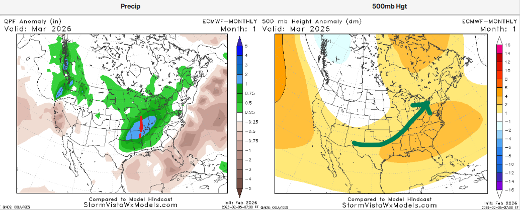
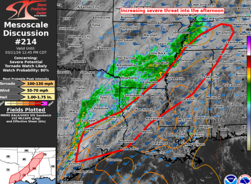
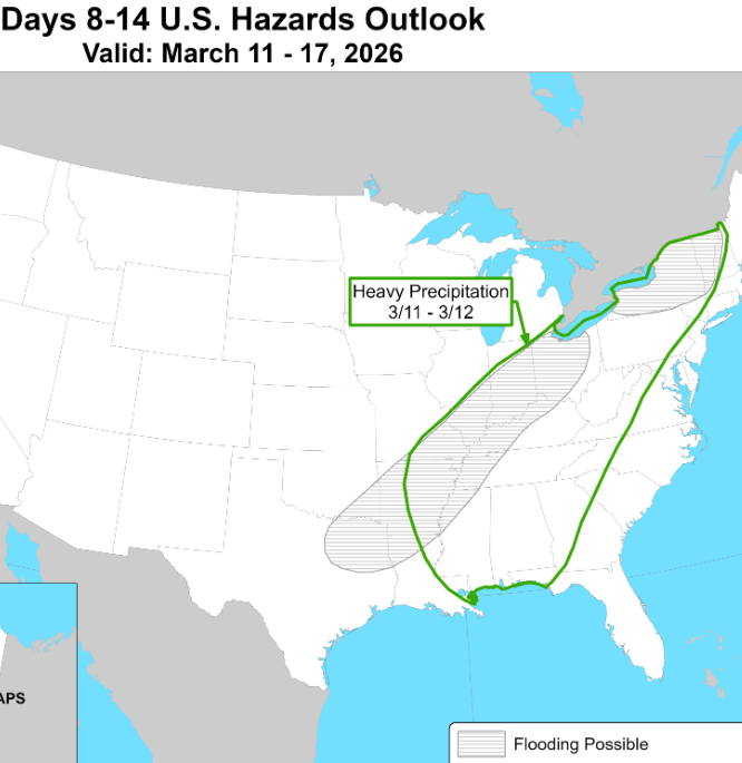
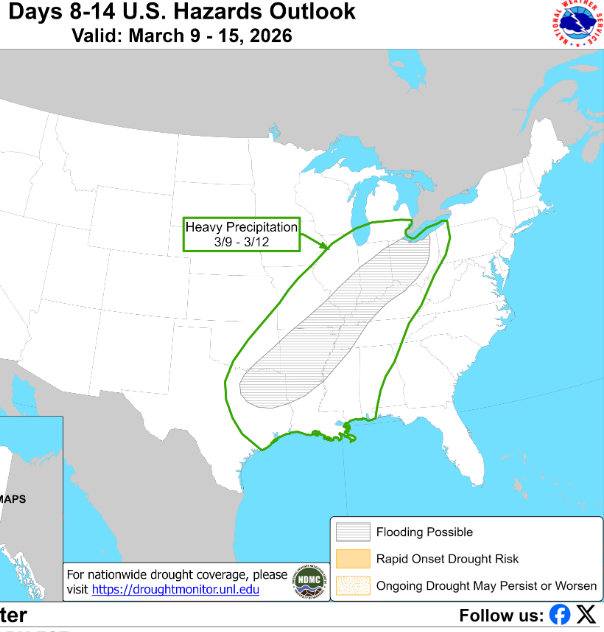
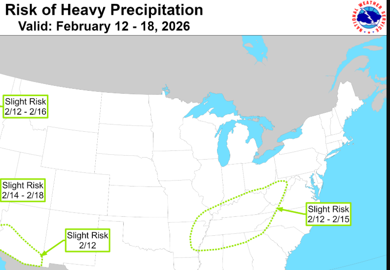
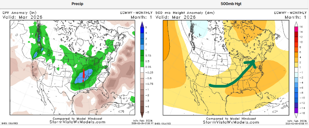
Good to see more severe weather interst this season. Not everyone digs it, but a few of us are down! If Tuesday gets going in the Southern Plains and Ozarks then pattern recognition calls for sloppy seconds our way. See Day 7 a few posts back for Tuesday. More recent quoted 8-14 day post is six days old and the chart is way out of date. Heavy precip made it into the WPC 3-7 day but no severe. Next Wednesday Mar. 11 the the door is open for continuing severe, even if no new development. Continuing is of course a messy outcome. Alas, it could all just be heavy rain. See below. Their hatched flood risk has not changed much for the Mid-South (just expanded) since the flooding hatch is a hybrid River and snow melt outlook too. CPC chart from Wed. Mar. 4
-
probably a decent approx. Severe Wx doesn't get outlooks so far out. Rest of this week prolly hangs up to our west. Next week could get scrappy. Either way heavy rain may become a risk. s
- 373 replies
-
- 4
-
-
- severe
- mountain snow
- (and 1 more)
-
I give winter an B in southeast Tennessee. Snowfall was slightly above normal IMBY which lifts it above C. A is reserved for a six inch thumper. B means I'm not complaining. I'm actually quite satisfied. Fighting the trend is hard too, so really a C would be a win. Temperatures are about half-way between the coldest and the warmest in Earth's history. Warm periods include tropical forests on Greenland and Arctica. Ice Ages oscillate between glaciation periods (what the public refers to ice ages) and interglacial periods which we are in right now (within the broader Ice Age). Will we glaciate, hold, or climb out of the Ice Age? If the latter it would be an order or two magnitudes SLOWER than the current trend of warming. What has happened in the last 150 years and what is very likely in the next 150 years is 10 to 100 times faster than natural warming driven by Milankovitch Cycles. Rate is the problem, and why we assign the cause to human activity. I'm not calling for extreme action since cheap energy is the fastest route to end poverty, but I want to acknowledge the research. That's probably enough outside of the specific Climate forum, but that place is a hornet's nest. From this point forward, look for me in the Severe Weather topic of our Regional forum.
-
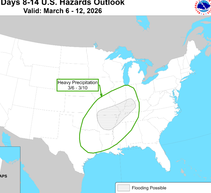
Appears that the first third of March could be active for severe. We have a remarkable signal for west trough and east ridge, with a strong jet stream driven by the still cold Arctic. SPC already has Wednesday in their Day 6, and that's probably just the beginning. Sometimes it's easier to infer long-range things from the heavy rain outlook(s). Grey flooding is pretty much the 3-7 day outlook from WPC, but this is the long-range from CPC. Period below could feature record high temps from the Mid-South through Tennessee to the Mid-Atlantic. Heights look particularly anomalous over the Mid-Atlantic. Less extreme heights over the Mid-South with still near record surface temps could open the door for severe. Surace details are always TBD, especially a week out. In this situation one can be more confident than usual about week two moisture with the temps (CAPE) thanks to pattern recognition. Several troughs pass without driving the surface front south. That's a recipe for building moisture. All that said, those severe weather anxious should not worry 10 days out. Storm chasers though, need to get ready to roll. Both can be true. Chance of one place being hit is low. Chasers can go to the forecast area though. My spring mode is activated.
-
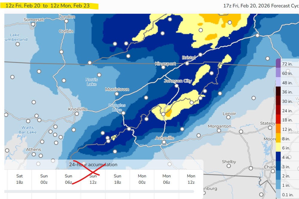
We live vicariously through the Sierra Nevada cement snow. Also we're spoiled by a good season in most areas. Some years we'd be salivating over this weekend. Let's have some fun with the upside potential 10% chance from WPC experimental probabilistic precip. portal from the Winter tab. 72-hr fcst ignore the 24 hr. Note that 50/50 most likely model forecast consensus lines up with the main WPC front page and winter page. Probably not much snow south of MRX in the Valley. Let's see if the Tri Cities can surprise.
-
AIFS is on board from northeast Tennessee and points north and east. Upper Plateau would still need more help. Euro gins it up farther east, but I think it tried that with Giannis. While I don't see Chattanooga involved this time, I'm hoping for something like the GFS (or overall blend). Still need to get some ski runs in up at elevation. WPC has minor impacts probs already for Sunday and Monday. I like the same areas.
-
We are at the point in the season where I'm more interested in severe than snow. Of course I'm in Chattanooga. If I was up I-81 I'd have a better attitude. Great thing about next week is that little lead trough through the Great Lakes. Our southern trough is not the first; so, moisture return will already be in progress.
-
That one really pissed me off! Especially after the Burrowhead crap in KC the week prior. Fortunately KU won a natty several weeks later. Weekend of the 22nd has F U Chattanooga vibes all over it. Could snow along I-81. Other solutions are rain everywhere - winter over. I'm a little salty because I haven't gotten the kids up on skis yet this year. Perhaps the MJO coming around by early March will give the Mountains another chance or two.
-
The really cold classic winter pattern is probably over. However bowling balls and other vigorous systems can still bring snow for another month, especially I-40 north. Indeed the torch does not last forever and the 16-20 day trends back toward normal temps.
-
My guess is that level of damage is why Mississippi is slow to get restored. NES is close to fully restored. @Carvers Gap my charts above are just as likely to be fulfilled by the polar jet as the STJ since it's still early season. I'm agnostic as to which. I just want action, ha! All, if we transferred some of the CAPE from the February thread we'd have a decent shot at severe. Sorry it's Free for All Friday!
-
Welcome to the land of Nada this weekend. You're a week late, ha! Yea the clipper has some gumption on clouds physics. Separately, we need to re-open Politics over in Off-Topic to let off some steam. Better there than here!

-
Ice storm started as a heavy rain outlook from CPC. Let's not do that again! Instead, how about severe weather?
-
Chase early. Chase often!
-

Jan 30th-February 1st 2026 Arctic Blast/ULL Snow OBS Thread.
nrgjeff replied to John1122's topic in Tennessee Valley
Few flurries in Chattanooga Sunday evening. I did a double take. Hoarfrost is as beautiful as ice, with zero impacts. Winner! The moonlight pix? Those have 99% solar eclipse vibes. Only 19 more years! -
Jan 30th-February 1st 2026 Arctic Blast/ULL Snow OBS Thread.
nrgjeff replied to John1122's topic in Tennessee Valley
Above was a layup forecast with this low-level profile and upper level cold. -
Jan 30th-February 1st 2026 Arctic Blast/ULL Snow OBS Thread.
nrgjeff replied to John1122's topic in Tennessee Valley
Regarding Chattanooga proper, we're just not a northwest flow town. I'm quite happy with the event though. Signal Mountain may restart if it hasn't already. Might as well be another Universe. As for Florida, ever since the Gulf of America, lol! -
Jan 30th-February 1st 2026 Arctic Blast/ULL Snow OBS Thread.
nrgjeff replied to John1122's topic in Tennessee Valley
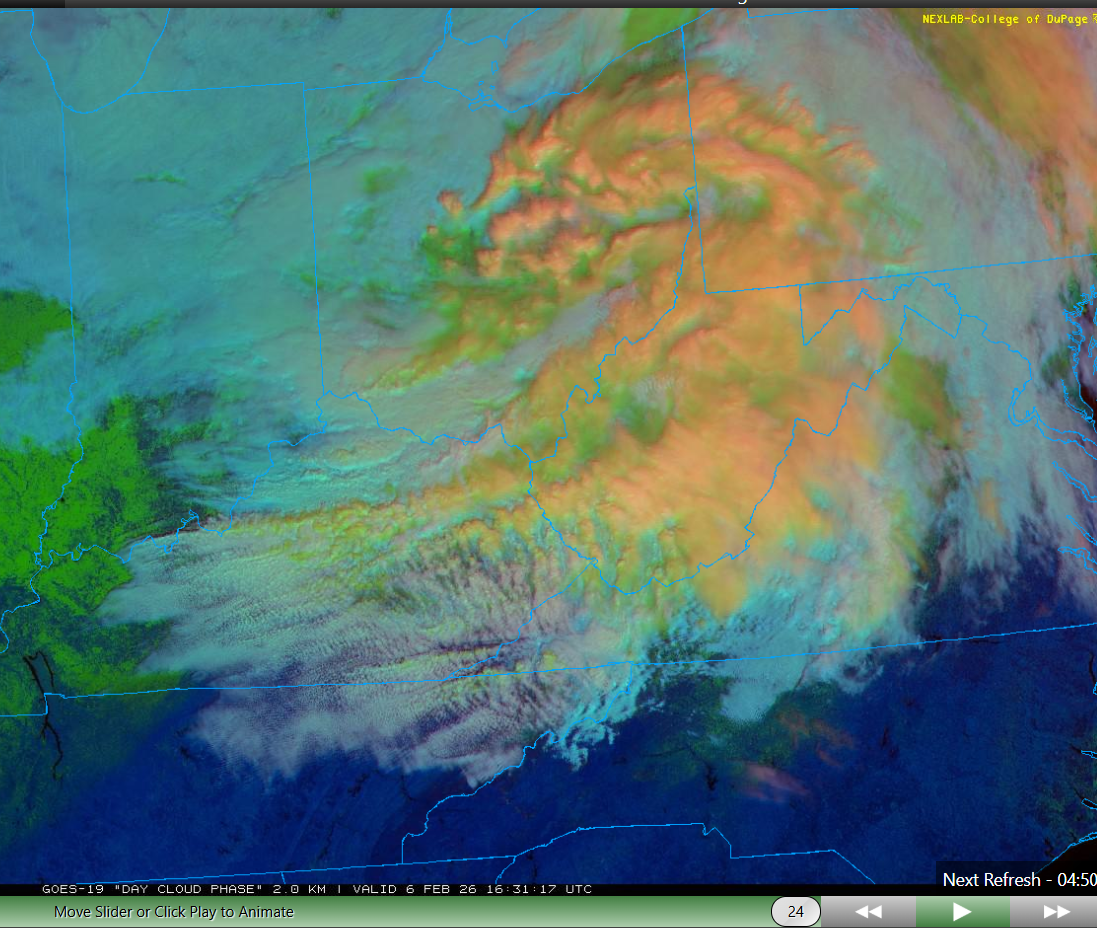
Hytop looks like an elevation map west of Chatty. Y'all enjoy! Then northeast Alabama drew a winter wx advisory. Where are or North Bama crew? Separately @Holston_River_Rambler lee of the Lakes had to be producing at the time of your image. RGB at the time had the orange tint to clouds.
-
Jan 30th-February 1st 2026 Arctic Blast/ULL Snow OBS Thread.
nrgjeff replied to John1122's topic in Tennessee Valley
We are officially past doubling down in blackjack. We have achieved a Hard Way in craps. Pays more. Two inches East Brainerd. Light snow continues. -
Jan 30th-February 1st 2026 Arctic Blast/ULL Snow OBS Thread.
nrgjeff replied to John1122's topic in Tennessee Valley
Definitely a Midwest type of snow. Minnesota, KC, whatever. It is unusual in Chattanooga. We're enjoying it! I may be closing in on two inches. Definitely 1.5 blowing around.