nrgjeff
-
Posts
4,251 -
Joined
-
Last visited
Content Type
Profiles
Blogs
Forums
American Weather
Media Demo
Store
Gallery
Everything posted by nrgjeff
-
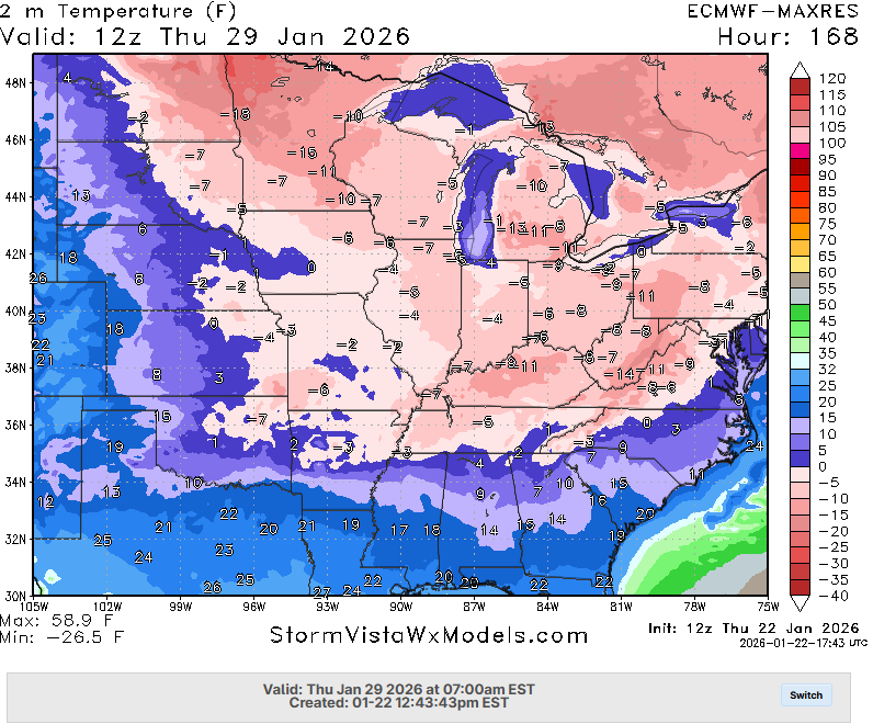
End of the month system still shows up on GFS and AIFS Euro AI. Other ensembles are of course all over the place. That'll also have implications on the High Risk for much below normal temps from CPC.
-
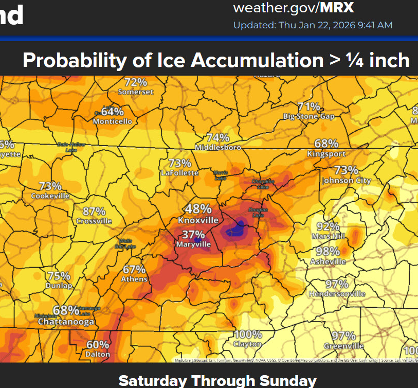
Memphis looks to keep mostly snow and sleet this first wave. Concerns remain on Sunday. Reliable models are split between more sleet or a slug of freezing rain. Nashville is of course subject to everything running cold. Several hours of all rain off ramp is in jeopardy. Sleet remains an exit ramp. Otherwise, major ice storm there - continuation of North Miss to southern Mid-Tenn. Chattanooga will stay ice longer than forecast into tonight. CAD is c0ck blocking the warm nose.
-

Fall/Winter Banter - Football, Basketball, Snowball?
nrgjeff replied to John1122's topic in Tennessee Valley
I want to make sure that's not Barrons Wx. Their official page is good. They were a major pioneer in weather radar display for commercial use. Much respect! I'm just struggling with his forecasting lane. -
Chattanooga is all freezing rain. Light at the moment - mercifully. No more sleet. Radar above confirms it's all rain aloft. QPF is going to be all ice until sometime this evening. Temps are way under forecast and cooler models keep it below freezing until later in the evening.
- 618 replies
-
- 3
-

-
- observations
- obs thread
- (and 1 more)
-
Yes @Knoxtron that's the line, but keep in mind it's aloft. Surface manifestation can vary. Also with ice it's not a clear rain/snow line. Otherwise all snow north of it right now. Mixed variations of pain south of it. My driveway in east Chattanooga mostly thawed thanx to apparently enough solar radiation coming through the clouds. Temp is 30. Couple hours ago I thought my glacier of the week had started. Plenty more frozen precip is incoming though. BTW is this gonna be the obs thread? We have a pinned forecast thread.
- 618 replies
-
- 6
-
-
- observations
- obs thread
- (and 1 more)
-
Fall/Winter Banter - Football, Basketball, Snowball?
nrgjeff replied to John1122's topic in Tennessee Valley
Bless BAMs heart the Euro, NBM and everything else knew also. If they think nobody knows about other models.. shit! Meanwhile I'm up for jinx post of the year.. CAD never wraps around in winter (CHA). Only when I want to chase storms it stabilizes things. Revised rules. CAD wraps around only when I don't want it; kills storm chances, promotes ice. When I want help for snow it fails. KCHA is running a couple degrees (or more) below guidance. Still think we'll thaw Sunday, but I'm gonna need power through Saturday for college hoops on TV!
-
Could be in places on the bubble, re sleet vs FZRA. Love the Bon Jovi reference. Rock on!
-
00Z follows 18Z colder than earlier runs. Damn! Hoped 18Z was just a blip. Perhaps I jinxed Chattanooga several pages back with.. I'm not too worried locally. CAD only wraps around when I want to chase storms! Welp. We'll see about that on Saturday. Joking aside, all this does is increase confidence in a devastating ice storm from the Mid-South to Mid-Tenn. This is a truly upper end event. Models are split on the sleet vs FZRA question in MEM. Most reliable short-term ensemble favors sleet. Same NAM. Couple of the newer hi-res models FZRA. Then for BNA the colder temps simply boost FZRA amounts. MEM is living on the edge between damaging and truly catastrophic. BNA is just living on the edge I guess. Then up in northeast Tennessee, y'all in the microclimates gotta take it from here. Good night and be safe.
-
Broadly, the case for the warmup is a robust southern flow. This is much stronger than a usual winter system. Column is TOTALLY saturated up to 400 mb or higher, offering little chance for evaporative cooling regardless of how strong the lift. Recon actually helped models key in on the kinetic strength and moisture depth. I don't wanna be the downer, but we always knew it could go either way. Went warmer. Also remember in the day 8-14 range CPC highlighted this as a Heavy Rain event. Well, we're almost full circle.
-
MRX ice chart looks reasonable to me. I have not looked at microclimates north of say Cleveland, Tenn. Generally seems to get the downslope foothills and cold stuck a little north side of Great Valley. I like it a lot around Chatty and surrounding mountains. GFS is too far south. I am not at all concerned about its local ice forecast. RAP might as well plant a Quebec flag in North Mississippi. Quebec basically has the North American ice storm of record from 1998. No I don't believe that's in the cards, but MEM 1994 (displaced south) could be.
-
Bigger problem for North Georgia. In spring (when I wanna chase) it curls around and stabilizes everything. In winter the warm nose usually wins. Hey @jaxjagmanwe do have Day 3 Marginal in South Bama and text mentions tornadoes!
-
Yeah the model ice forecasts are not great this set-up. One has to manually look at QPF and dissect which of those periods are below freezing. I get lower ice in Chatty than NWS. I get higher Knox northeast. Lee side foothills downslope? I give up!
-
That scenario makes a lot of sense in Chattanooga. Knox and points north could have more light precip. Sunday night. In this business anything is possible for both locations. We'll know Monday morning.
-
It is harder than the Plains; and, that's a high bar. When someone in the Northeast says they got it hard I laugh in their face. Y'all been looking at it for 3-4 days inside the US! Models got it onshore those same days ahead. I will concede the coastal front is hard - and has crushed many a snow lover hearts.
-
GFS is consistent with another storm signal in a week. One run warm nosed - apparently always a possibility. The rest are all snow. Euro will find it again. Random cold air thoughts. Being from the Plains we ALWAYS locked in shallow cold harder than models. I tried that a few times in East Tenn. Learned real quick I'm not in Kansas anymore. Warm nose wins in the Great Valley. Then east of the Apps right back to cold wins, bigly CAD right up there with Denver. Amazing.
-
Bless BAMS heart, there is no chance of an inch of ice in Chattanooga proper. Signal might get a half inch if they stay below freezing, but that's clickbait in town. Human should have QC'd it. Obviously it's the Mountain, but it seems a bit much even there. Downtown to East Brainerd, I have basically no concern about life. Yeah prolly some power outages Sat. Hopefully not my house. Roads should break up on Sunday.
-
HRRR is doing that also Mid-South to Mid-Tenn. If that MEM forecast sleet manifests itself at FZRA they are looking at 1994. Some of the rest of North Mississippi is Quebec 1998. OK I'm out. Work intensity rivals that leading up to 4/27/11.
-
It needs to cut like the 12Z GFS. Hammers Chatty all snow Day whatever that is.
-
Been up since this morning. I missed it on the Public page. Looks considerably better than some of the lighter (blowtorch) charts I've seen. Mostly lines up with national WPC stuff too. I'd still back off for KCHA (use those lower charts) but I like this one points northeast in the Great Valley. Crazy downslope still shows in the foothills, while keeping the other side of the Valley locked. And those elevations are in the warm layer.

-
Yeah the early charts were a little light on snow and ice for northeast Tenn. Euro is in line with the national charts from WPC. MRX will update accordingly. I still feel relatively safe in Chattanooga. I see trouble from Knoxville northeast. Relative in Chattanooga means some ice but not crushing. Knox to TRI needs to watch that cold lock more. Separately, lol I was just kidding about the AI. Guess it's so.
-
This would be a huge problem across the entire Eastern Interconnect. Temps go all the way to the Coast from NYC to New England. GFS (not shown) has a gem of a Miller A very end of January.
-
Fall/Winter Banter - Football, Basketball, Snowball?
nrgjeff replied to John1122's topic in Tennessee Valley
Well this did start out as a heavy rain outlook on the CPC 8-14 day And now we have CAPE and some shear in South Bama on Sunday. -
AI read your posts on the Internet. OK I'll let @Scottie16 answer for real.
-
Duration of extreme cold for areas without power and heat will be concerning. Mid-South to perhaps Mid-Tennessee are at risk. Then Mississippi is a whole other level of ice storm forecast.
-
Sweetwater could be that line in the sand for the Great Valley. I'm pretty sure the warm nose wins south of there. Sweetwater and Athens are a slightly elevated area relative to CHA and TYS. Could be less certain north of there. Chattanooga local notes: Signal, Lookout, and Flatop are not going to get as warm as KCHA. Could stay <32 deg for the duration. They are all still locked in for Warning criteria ice. Downtown to maybe East Brainerd, I'm much less concerned - except Saturday. Then Sunday may cut.