nrgjeff
-
Posts
4,251 -
Joined
-
Last visited
Content Type
Profiles
Blogs
Forums
American Weather
Media Demo
Store
Gallery
Everything posted by nrgjeff
-
Wednesday would be a lot more interesting if low level winds were going to back. NW flow with modest dewpoints could give some nice, sculpted updrafts though. Wed might be decent for photography. Then early next week we'll see if we can get a system into the Mid-South. Current forecasts have it weakening as it moves out of the Plains into the Midwest. Just scattered showers for the Mid-South.
-
Latest drought monitor is out. Chipping away at the extreme drought in Middle and West Tenn. Rainfall tally ended Tuesday so East doesn't have what just fell. I figure North Mississippi improved too. We have another week or so of a somewhat active pattern. Then it wants to shift back to the Midwest - which could still clip the Mid-South. East Tennessee needs more help before that shift. Some mid-range guidance has rain chances again in the 11-15 day period, so the week of May 18. Models try to bring one more trough through the Great Lakes that period. We'll see. Climo is gonna start favoring the Plains in late May.
- 373 replies
-
- 1
-

-
- severe
- mountain snow
- (and 1 more)
-
Today has potential if it's close. Who cares if it's sloppy, low visibility, full of trees and hills? In the South we go mess or we go home, lol! Worst case you get a country drive, and get back in time for the NBA playoffs. Yeah that overcast is a real problem south of the boundary. It'd be acceptable north of the boundary until early afternoon. South of the boundary really needs some heating soon to start destabilizing. Lapse rates are there above the low-level crud. Yeah the LLJ is weakening and retreating north. However upper-level winds remain stronger than what is necessary. Absolutely need the outflow boundary to locally back winds and create favorable SRH. 10% is probably right for just the boundary*. Otherwise looks like messy storm modes. Even on the boundary storm interaction could be a problem. What's new in the South? * I see two boundaries. Yes along I-20 is the coastal front or some other dewpoint differential. It lumbers north more in Alabama thanks to less overcast (still I-20). Agree that's the one for the best chance of discrete sups and tor. Synoptic lumbering front is in North Mississippi and North Alabama (almost Tenn border). It'll have storms, but more interaction and more problems. Also if one overlays the hatched hail with the hatched tornado, indirect way of looking for sups, it favors Miss. 10% in Bama could be messy mode. Again, they all could be messy. If I'm in JAN or BHM I'd plan on wrapping up work a few minutes early to chase. If it looks like crap enjoy a rainy evening watching sports at home. As for me, no plans to depart Chatty.
-
Wednesday is another outflow boundary special. May might feel late for the Deep South but early May is still prime time climo down there. LLJ is gonna be veered off quite a bit; but, strong upper-level winds will create robust speed shear and decent directional shear right on the outflow boundary. Said boundary will be key. Away from that locally higher low-level shear the storm relative shear won't quite support tornadoes. I think the narrow 10% is the right call for Wed. Otherwise it's straight wind and perhaps hail from hotter cells. Storm mode looks like a mix of segments and blobs, with a few sups. Valid Wed. May 6
-

Fall/Winter Banter - Football, Basketball, Snowball?
nrgjeff replied to John1122's topic in Tennessee Valley
Well it's Facebook. Some of that looks like La Nina like the central Rockies and OV. Though the immediate West Coast and much of the Great Lakes checks out. Who knows the model or methodology? I just learned Tennessee basketball picked up the #1 offense thanks to transfers and the like. What? Football comes first. It's always basketball season in my head! -
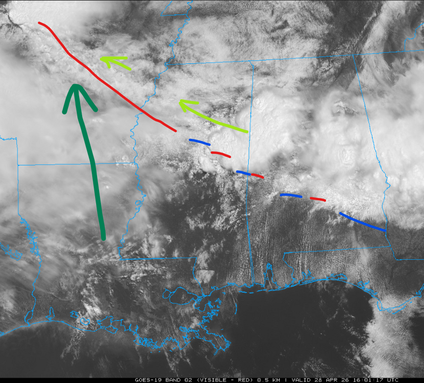
Today is a textbook outflow day. Synoptic boundary is up on the Ohio River but cut off from greater instability. Outflow boundary OFB is highlighted. Stuck in the Deep South. Lifting north in the Mid-South. Northwest Arkansas has hailers going on, just north of the boundary. If that roots, it could ride down the OFB with a vengeance. Other storms in Texas (off this chart) are rolling east. That'll put 'em in the open warm sector and/or crossing the OFB. If they latch on and turn right, ope! So I like the 5% hatched for now. Need to see where the OFB ends up, which storms interact with it, and where. Small 10% tornado would not shock me later, probably in Arkansas. Continue 5% hatched MEM metro into North Mississippi. Then a bunch of wind rolls into our Region. Looks like initial sups quickly congeal into clusters or 1-2 lines. At first I was gnashing my teeth that I can't chase this. Turns out it'll probably be messy. Keep a vigilant eye out in the Mid-South.
-
Drought breeds more drought. Yeah we had the somewhat elevated storm issue with the thunder. Sound waves love to bend down when the boundary layer is cooler. So the bottom line is that we got crappy sleep for a poor trade off with not enough rain. We have another chance tonight. Probably come with booms and bangs again. Might come with some straight wind. I'm not at all worried about rotation in East Tenn. However, I will have some sabre rattling in the Severe Thread for West in about an hour.
- 373 replies
-
- 2
-

-
- severe
- mountain snow
- (and 1 more)
-
Monday 16:30 Day 1 update looks similar to 13Z. Moderate looks good. Our Mid-South will has almost as great a risk with prefrontal convergence and outflow left from this morning. The latter is a little diffuse but as of Noon Central Time had lifted just north of Dyersburg. Everything from the Missouri synoptic boundary to the convergence zones in Arkansas should light up this afternoon. Initial afternoon tornado threat West Tennessee and West Kentucky should evolve into straight winds this evening. This is the western third of our forum - not much east but thunderstorms tonight. Tuesday looks volatile enough to justify Enhanced in Arkansas with the update here in a few minutes. CAMs are nearly unanimous with outflow from today lifting north out of the Deep South into the Mid-South. Models have a clear boundary from the wind shift to the temps and dews. Synoptic boundary may be up on the Ohio River. Boundary I'm eyeing may be as far south as Memphis into Arkansas; otherwise, north of I-40 by Tue afternoon. Wind shear all levels will be robust that far south. In this case, on Tuesday, I'm much more interested in the cooking outflow boundary than the cooler synoptic one.
-
Hey @jaxjagman thank you for checkin yeah @vortexse93 is safe but he got a hell of a show! Monday looks late and west. Oh joy* , late is a Southern tradition in spring like football is in the fall. One of those is not like the other. In fact with my MLB team(s) so far, how long until fall football? Tuesday is my main interest. SPC notes the MO/KY boundary which is more the sinking synoptic front. It looks active; could be messy; and, could be nasty. However I'm a lot more interested in Arkansas. Well I would be if I was free. Tuesday Arkansas should be home to a farther south outflow boundary OFB from Monday. That OFB could be draped from GA/AL/MS curling back up into Arkansas, and intersecting the synoptic boundary in western Arkansas. Said OFB is currently forecast to get free of rain early in the day - and cook well into Tuesday afternoon. Unlike some previous scenarios, the wind shear is present in the South. Speed and turning are noted from the LLJ to the upper jet. Storm motions might not be crazy either. We'll see. Oh yeah Arkansas isn't technically our state. Well, the whole mess of clusters, blobs and discrete supercells will roll into Tennessee on Tuesday night. Joy!* *Sarcasm part of my signature is very relevant for overnight severe.
-
Drought breeds more drought. Monday continues to look like a Midwest shift. Sure they'll be some wind in the Mid-South and probably Mid-State, but I'd put the tornadoes in eastern Missouri, southeast Iowa and of course Illinois. Tuesday now looks more interesting in the Mid-South. Jet stream truly shifts south. LLJ looks a bit veered, but with the upper jet from nearly straight west that's plenty of turning with height. Tuesday much more moisture will be in place vs kind of JIT on Monday. Finally Tuesday outflow will be all around after Monday. If temperature forecasts are correct, those cooking boundaries will be ready to go Tuesday afternoon with their inherent locally higher storm relative parameters.
-
Yeah Monday is coming into focus in the Mississippi Valley. Worst severe may be just north of most of us up in Illinois. Then we'll see if STL can double down on Missouri as the Show Me State. For the storm anxious around here.. Exit ramp now looks more like warm mid-levels than MCS washout. Guess it doesn't matter either way if you don't like tornadoes. Either way if NWP holds, should be some wind west Monday night. Other hazards are TBD; much can change either direction until then. Fairly solid upper level winds remain over the Deep South the rest of next week. Could be another chance or two. However a dry dewpoint push after Monday could mitigate rapid moisture return. We'll see.
-
I notice sometimes northeast TN (Tri cities especially east of MRX) can get going in the early afternoon on what's otherwise a Carolina day. That's mainly later in the season. Carvers may be talking about other examples. All I know is that it frustrates me to no end. I'm not going to chase east initiation, because it creates a long drive home. Euro came in a little hotter Monday. Nothing major but definitely supports a severe weather D6 outlook. Winds from 850 to 500 turn pretty well nearly 60 degrees vs say 45 deg. LLJ is still shown weakening / lifting north. That latter detail and/or any midday rain keeps Monday off the crazy train. Definitely watch it though.
-
Yeah @jaxjagman Tennessee overnight is one of the highest state proportions in the Union. @Runman292 I was gonna say that's just since I moved here, lol! But Jax is right. Living in East Tennessee reminds me of living in eastern Kansas. Things get rockin' in the western part of the state, sometimes middle. Then the leftovers roll through at night. Occasionally it does start east and we get tornadoes too. Otherwise just like I now drive southwest to North Alabama, I used to drive southwest toward Wichita. Which brings us to Monday. Still looks possible Mid-South. Euro has the ol' east crap-out. Fresh 12Z GFS keeps it going. A lower scenario option is always the classic midday MCS shut-down. We'll see.
-
With 5 of the next 8 days in outlooks, I was hoping chaser drama on X would cease, and people would concentrate on the forecast. Silly me! What was I thinking? We shall refer to Monday as Monday or whatever day outlook it is (as time passes) and omit the date which shall not be named. Same for that year. Possible another day crops up next week too. That still doesn't make it that year. It makes it spring in the South!
-
Friday through Sunday looks like a heavy traffic circus in the Plains. Saturday and sometime late Sunday looks like left-overs from the Friday and Saturday Plains come through the Valley. Should be just showers, not severe, as upper energy and LLJ all eject north and/or weaken this way. Monday could be more interesting, especially if the GFS is closer to the truth. Morning wave will create complications with the instability forecast. However by Monday evening the LLJ is forecast to recover over the South with a back wave. That'd be fireworks. ECMWF is less convincing with the second wave but does have some LLJ recovery. Both have adequate speed shear and turning. Questions remain at the surface and also if the second wave is real or trash. SPC has Day 7 into the South for Monday. Even with all my concerns, late April temps often find a way to recover. (I also recall a couple times the Georgia cool wedge oozed west and cut off even Alabama). They are prudent to outlook Monday just in case.
-
Yeah we got rain last two fronts, which is some encouragement. QPF came in under, not a surprise in drought - but at least it's raining. See if we can accomplish more this weekend into next week. Even poorly timed waves (see my severe rant) can bring rain. Seems like a decent bet. Then we'll see how long we can milk the southern jet stream next week. Could it be a drought breaker? Could it just add humidity before the SER gets on steroids? I don't believe the CFS or Euro weeklies. Check back in June!
-
We're not doing watches and warnings. Season's canceled. That's not commentary on the system. That's angry storm chaser venting. This weekend into early next week I would bet a stack of chips on poorly timed waves. Well, that's good for the storm anxious. Note it's a week out. I'm being a pessimist more than a scientist today.
-
Most of that QPF comes in the 11-15 day period, which is of course the least accurate. I've seen so many CPC 8-14 day heavy rain outlooks bust. True they are mostly slight risk, which don't even make the composite chart, but the SER just won't break.
- 373 replies
-
- 1
-

-
- severe
- mountain snow
- (and 1 more)
-
Severe season in the South is captured in the classic John Candy Vacation quip. Sorry folks park's closed. Cannot find the GIF on any source. Must be licensing BS. Anyway the cancellation is good news for those with storm anxiety. CFS wants to get into more active phases, but the EC and GEFS weeklies don't seem interested. We'll see.
-
Fall/Winter Banter - Football, Basketball, Snowball?
nrgjeff replied to John1122's topic in Tennessee Valley
Two years ago we were all reflecting on the second total solar eclipse in seven years. Now I look up and see boring. Only 19 more years until the next big total solar eclipse in the South. August 2045 will offer six minutes of amazing! -
Rain Saturday night was an Easter miracle. I don't see much more for a couple weeks. Might be able to get some quality precip late April but delays would not surprise me. Gotta chip away at what will become a significant SER and Mid-Atlantic ridge. Then getting into May (note weeks 3-5 are notoriously awful forecasts) charts show WNW flow and only normal precip. Meh. Weeks 3-5 are considered the un-sweet forecast range beyond daily extended forecasting yet not covered by reliable seasonal signals. Hope for all our yards is El Nino signal kicks in quickly in June. Normal heights and seasonable moisture would open the door for summer thundershowers. We'll see if / how the drought impacts dewpoints though.
-
Memphis Pyramid Effect.. or the Great Wall of the Mississippi River.. or a stubborn Southeast Ridge. My chips are on the latter. Frustrating!
-
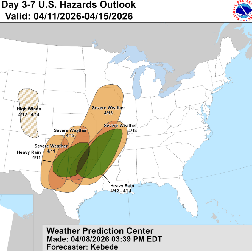
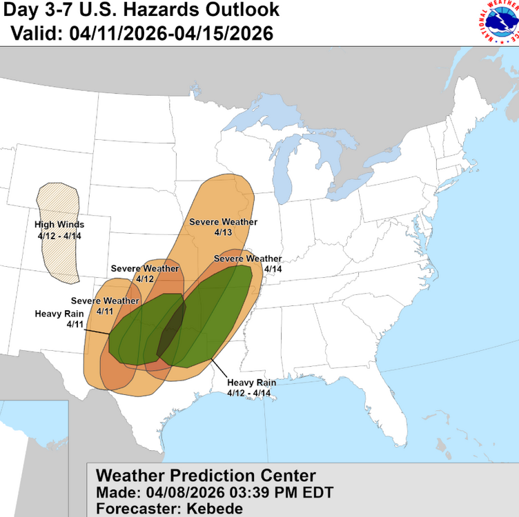
The Great Plains may have a good week. First we have this Tuesday trouble in Illinois, which may relaod on Thursday. The real Alley is up on Wednesday and perhaps again on Friday. There's no place like Kansas - except both the tornadoes and the Jayhawks have been in a coma the last 4 seasons. Looks like the early week Illinois system never sends a front our way. After Plains / Midwest system number 2 we should have thunderstorms in the Mid-South on Saturday. Timing and weakening LLJ limit severe chances IMHO. Then on Sunday we'd like to see skies quickly clear for Easter. Cool trough is forecast early next week. Next system is forecast late next week into that weekend. April 12th anyone? Oh my!
-
Mountains were pretty! We got a few runs up at Sugar. After hitting 80 in Chatty last week, driving up and seeing snow before reaching the Tri Cities was a trip. Great time with family spring break. So looks like the AC will be humming this weekend. Then back to slightly below normal temps next week (except midweek). Should even get cool and cozy nights and mornings a few days next week. WNW flow in early spring is a wild ride! Appears that the last few days of March will usher in a warm early April. Mid Atlantic ridge may not be centered over the Valley. See if it'll let in some April showers.
- 373 replies
-
- 1
-
-
- severe
- mountain snow
- (and 1 more)
-
Fall/Winter Banter - Football, Basketball, Snowball?
nrgjeff replied to John1122's topic in Tennessee Valley
Well here in the South I'd have said the same thing, lol! Tennessee, Kentucky, Alabama, Kansas and Auburn (NIT) all play today. My Wichita State is also in the NIT. Could be a fun day. Could be heartburn. What happened to Georgia? STL opened up a can of General Sherman. Not a huge upset 8v9 but an epic blowout!