nrgjeff
-
Posts
4,251 -
Joined
-
Last visited
Content Type
Profiles
Blogs
Forums
American Weather
Media Demo
Store
Gallery
Everything posted by nrgjeff
-
GFS has missed the system every run since the one posted above. Meanwhile the ECMWF and every other ensemble or AI model has it. So.. the GFS is trash. ECMWF is centered around Tuesday night around our region. Could be late Tuesday could be early Wednesday. First week or March is well within climo. It's not often but it happens.
-
Per the severe wx thread, got chances both week 2 and week 3. But, a big thing here, could get cold again in between. Can we do the snow and thunder thing? I'm half serious. Models are all over the place with a muddled MJO. Are we doing Maritime Sub or West Pac?
-
Thank you @jaxjagman re KU but I got Auburn winning it all. If so hopefully Pearl pulls out an Israel flag too. Can I say that in Weather? Cut down the nets while singing War Eagle and Am Yisrael Chai! Alright to the severe. Yeah next week still has the signal. MJO and others may not stick in the same phase for long. That said it's possible to reload week 3 per @vortexse93 chart. Temps could really swing around. Maybe snow in between? Just kidding!
-
It's 10 days out but most models have a Mid-South and Midwest banger (maybe even into Bama) the first week of March. Climo would support such a system if the wx pattern lines up. March madness starts early in the South. Since Kansas looks irrelevant this year (despite the yuge win today) my semi-moratorium on pre-Final Four chasing is not valid this year. Chase early and often - especially after the time change. However the system in question is still before any change. Plains may struggle later in the year too. All signals point to attempt the South. Patience is not a virtue this year. Chase early.
-
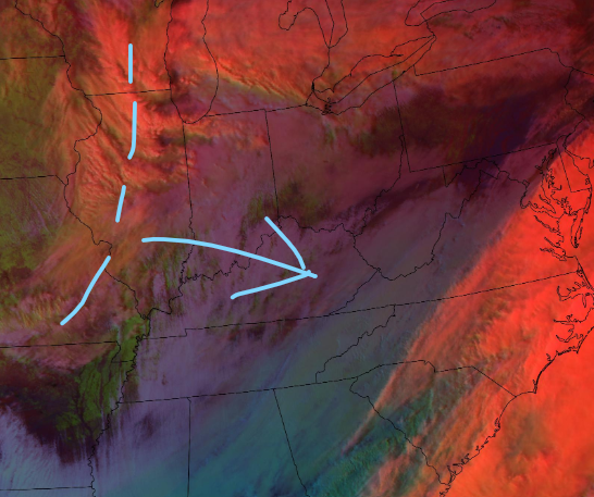
Nice to see the satellite meteorology trend is holding here. Mine was just from UCAR/NCAR. Satellite page: RAP Real-Time Weather And here's the northern stream energy for tonight. Looks juicier on RGB than vis or even IR. We go with what we like!
-
Yea and @John1122 will get six inches of Upper Plateau magic. Really light and fluffy feathers.
-
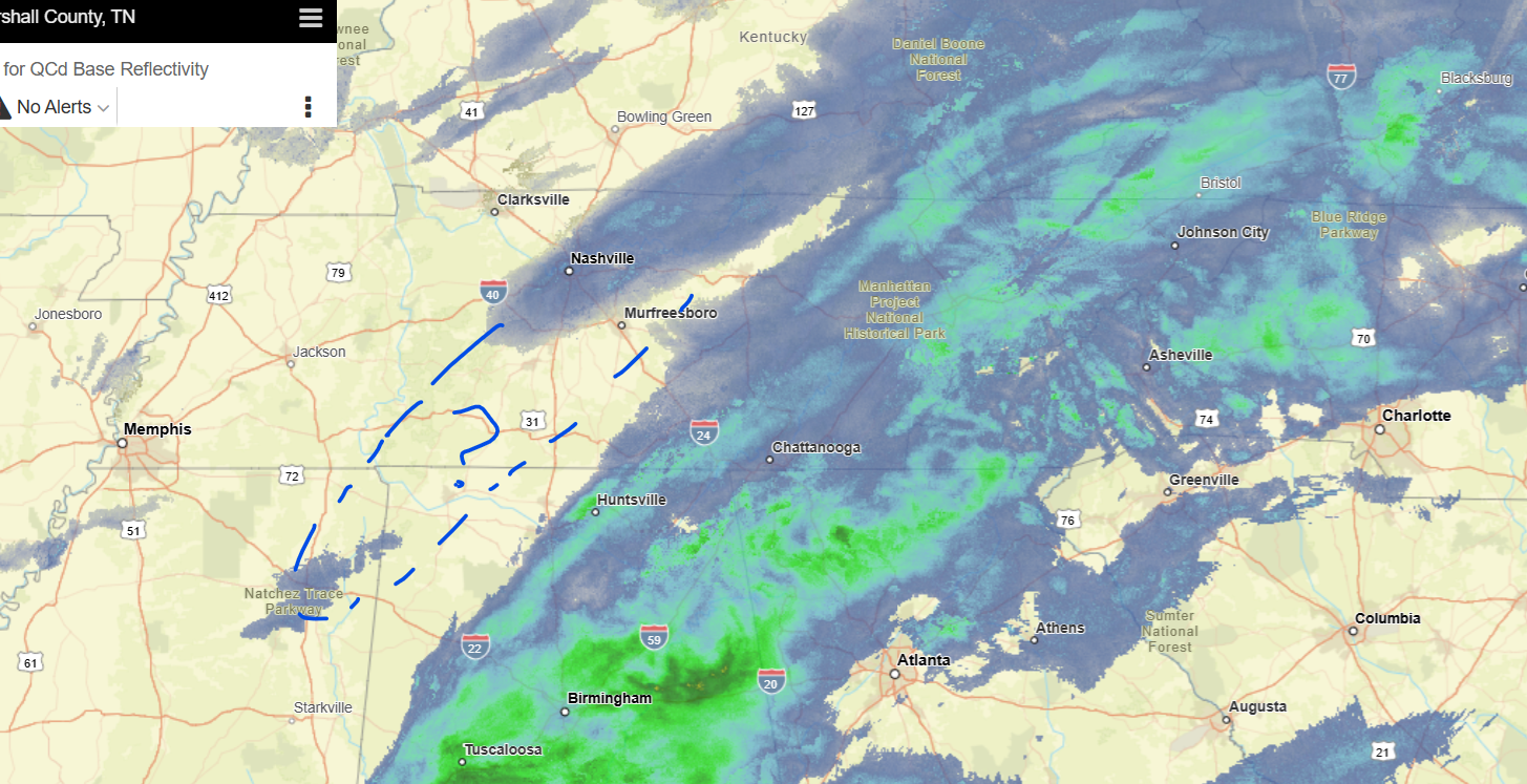
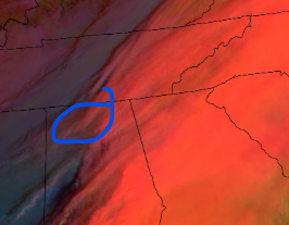
Just shy of 2 inches, and temp above freezing. Need some help in Chatty. Come on little guy, Snow Grogu, blossom and grow. You are our last great hope! Daytime cloud physics / RGB. Dark teal west of Nashville is liquid clouds, so tough to get more now. Maroon west of Clarksville is even lower clouds. Thicker clouds are intuitive and orange shades are ice or mixed.
-
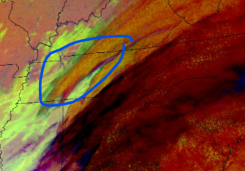
East Tennessee needs some love from that back area of lift and enhanced mid-level clouds. Likely some sort of elevated secondary frontogenesis. Some models have it filling in a bit mid-morning (later, and for East Tenn). Others (damn NAM) don't do anything for anyone. Satellite is the nighttime cloud physics. For a while I still preferred traditional IR, and it's still my goto for a quick view. Cloud physics shows greater detail though. How juicy is that in-between cloud on IR? Cloud physics helps hunting for mid-level hope!

-
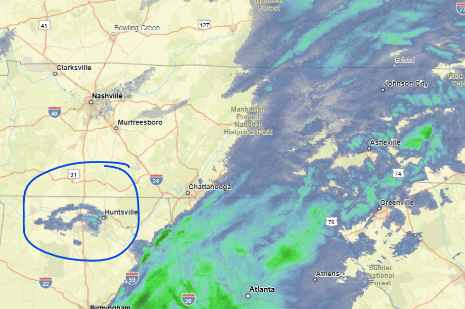
Better late than never! Chattanooga always looked good on the models to me. Not a big snow, but 1-2 inches. We have about an inch now. Looks like a pause is incoming. Could get one more encore, from which I usually don't expect much. However if enough mid-level moisture hangs around, and surface temps stay cold, maybe later today.
-
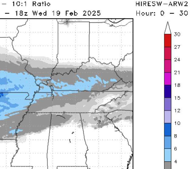
I like the models that bring snow into Chatty. Not a wish-cast, just makes sense with cold enough temperature profile and partial thickness. Surface could get up to 38 but that no problem, all else in place. Plus the surface will probably stay colder than forecast during precip. Now, the lee of the mountains. That's some cruel and unusual punishment - twice counting Jan. 10! Some high-res models agree with the snow shadow early. Then perhaps some NWFS will save last-minute when the lee becomes the windward side. Wind shift as system passes.
-
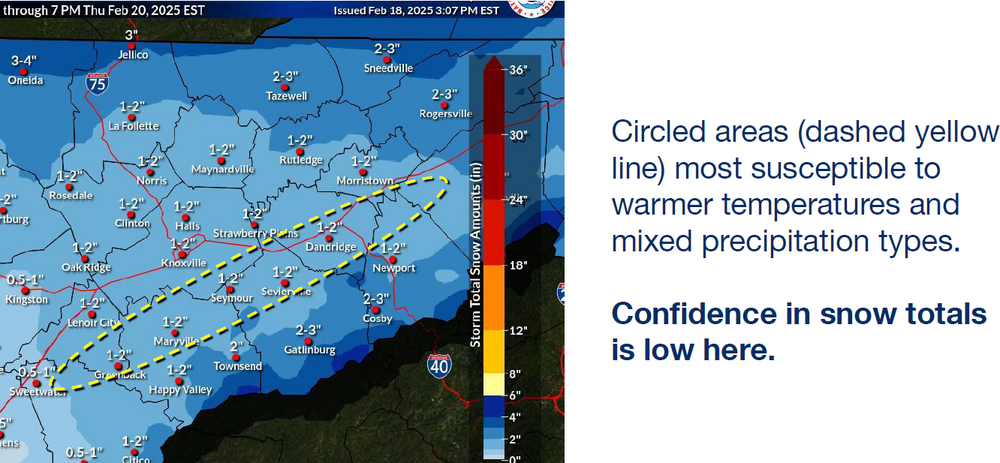
I'm at a loss why WPC and OHX/MRX almost blank southeast Tennessee. Whatever computer generated graphics HSV used has a little bit more light snow into Chatty. Seems like it'll be cold enough for several hours. Strength of cold airmass and high press should hold low level (all level) cold air. GFS and CMC do so. NAM and EC mysteriously blank Chatty. Or they're going climo. Temp profiles look as good or better than Jan. 10 when we pulled snow out of messy hat though. Yeah it's a month later - but it looks cold enough to me!
-

Fall/Winter Banter - Football, Basketball, Snowball?
nrgjeff replied to John1122's topic in Tennessee Valley
Yeah @John1122 and @Daniel Boone I miss Arctic Outbreak and Siberian Express, even cross polar flow. All this PV shit used totally opposite its true meaning is annoying AF. I can get on the SSW train, but never ever the strong PV cold. Weak PV = cold! -
Canadian got the Mid South clearing for the Eclipse. First model. It got sticking snow in Chatty Jan. 10 despite warm nose assault. Maybe it'll nail this one! Make Tennessee a Canadian province, lol!
-
Tee it up!
-
Yeah trailing energy is like chasing a stock trade that's already up 10%. It's a loser's bet. Euro is still south and kind of dry. Now that's a starting point I like over this GFS warm mid-level game again.
-
I'm woefully behind on the Forum. Missed the severe weather last week. Keeping it simple. Thunder then Snow. Tee it up! Saturday severe: Midweek hvy snow risk. They're not taking that into Chatty Day 7 (climo) but North Bama and North Ga are totally in play. :
-
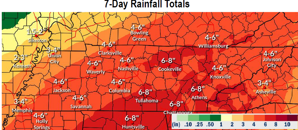
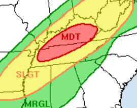
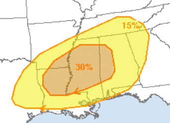
I was skeptical a few days ago but this 7-day chart may well verify. South end has received over half already. North side should get slammed over the weekend. The current (Feb. 12) for Saturday Feb. 15 WPC excessive rain is below the older QPF forecast. Today's excessive rain Feb. 12 is Slight northern MS/AL/GA and some southeast Tenn. Excessive Rain, not severe wx, for Saturday Feb. 15
-
Saturday looks like two rounds in the Deep South. A few weeks later in the season this system is strong enough to recharge for Round 2. As it is, the earlier may stabilize things north of US-82 Miss, I-20 Bama. Also looks like round 2 at night, so stable would be good! Then I-40 looks like another huge slug of rain. WPC has them getting more than southern Tennessee did early week. We'll see. Either way many folks are racking up impressive 7-day totals. Threats seem to all come together! Severe Sat. Feb. 15
-
Would have made a great time-lapse. As for 30 dBZ gettin' blanked, that's frustrating.
-
Valentines Day and Presidents Day have been good to me both in Appalachia (skiing) and back in the Plains growing up (imby). One year I failed to prep my Valentines for school. Rescued by a snow day! As for the 11-15 day period, most AI versions of Ensembles ooze the cold east eventually. GEFS does too. EPS and AIFS are a little slower and start warmer. EC warmer than USA stuff is kind of back to normal. I figure a slow go but eventually cold finds its way back in here. Favors BNAwx timing after the 11-15 day, more toward Day 20. We're also waiting for convection to gtfo the Maritime Subcontinent. When it shifts we can perhaps get more love from the MJO, again that Day 15-20 timing. Weekly models like days 15-20 also.
-
Severe thunderstorms would solve the problem. Just sayin' on Free for All Friday!
-
Virga passed over Chatty. It was actually pretty from the Interstate but I could not safely take a pic. Also not pictured, a small pile of snow remains at the shaded corner of my driveway from Fri. Jan. 10 snow. Two weeks!
-
Well Florida had its snow. SoCal be like, it's our turn! Sure beats fires. Perhaps that Western and Plains cold can ooze east to us in the 11-15 day. Guess we have to get through the thaw first. Baby steps.
-
12Z ECMWF is serving up the ol' Thunderstorms then chance of snow a few days later. Snow part is I-40 north. I'm less interested in an 11-15 day forecast than I am that I-40 is the usual routine. Even the thunderstorm part is a week or more out, and more likely Deep South than or forum. Mississippi maybe, but going into central/southern Alabama is Southeast.
-
Yeah my general rules are the following. 1. If we need cold air for snow we will get a warm nose. 2. If chasers want moisture return we will get cool dry air. Getting serious I think 2024-25 winter so far has been a wild ride from Nina to Nino influence. MJO been hoppin' and mixin' it up. Makes life like a box of chocolates.