

nrgjeff
-
Posts
4,251 -
Joined
-
Last visited
Content Type
Profiles
Blogs
Forums
American Weather
Media Demo
Store
Gallery
Everything posted by nrgjeff
-
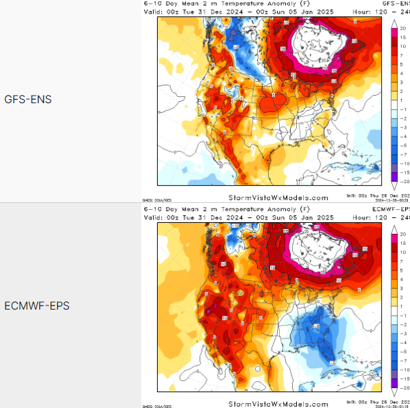
Quick look at 00Z ensembles. We can see from members and operationals that we have chances of good things, and chances of typical disappointment. Ensembles generally reflect the two less than ideal (but better than average) scenarios. Euro goes cold fast, but behind a quickly moving New Year's system. GFS has a more southern track, and a day later which makes sense south, but cold air is not in place. Either of those scenarios sound more realistic than a big ol' snowstorm, but anything is possible. It's still Day 7-8. Perhaps by the weekend we can talk about more details. Hopefully we avoid a debacle and instead escalate.
-
GFS tried to dump the cold West around Thanksgiving and it ended up barreling east. I'm normally quick to jump on the West first deal, with stubborn SER, but not this time. GFS has a history as noted above. Finally the AI versions strongly favor the Euro. Even the AI version of the GFS caves to the Euro. Merry Christmas. Happy Hanukkah. Enjoy the NBA Christmas lineup.
- 409 replies
-
- 11
-

-
They both still see that system but of course it's Day 12. Either way, evidence is building for a cold pattern starting a few days after the New Year.
-

Fall/Winter Banter - Football, Basketball, Snowball?
nrgjeff replied to John1122's topic in Tennessee Valley
Looks warm between Christmas and New Years. Warm Hanukkah. One way or another I have to use this.
-
It's a good sell signal. When they get too bullish, sell natural gas. Not trading advice! I don't trade gas. At least seasonable cold if not colder is still on tap for the first work week of January. Right during the warm holidays will be when to buy gas. Again not advice.
-
Hamilton Co. special weather statement is achieved. Guess it's not bad for December. It's not severe but it's not coal in my stocking either.
-
Rare good news from me.. AI versions have another sharp cold front around Dec. 20. Weeklies hint at it, but the AI version is full tilt cold into the East. The AI versions have been first to sniff out cold before. They typically don't just false alarm like the GFS. We'll see. If they keep stacking up wins I may have to convert to the school of machine learning. I'm just talking temps. If one wants snow in southern Tennessee... The only way to win is not to play. -Wargames
-
European Monthlies are severe all winter.
-
Wow that's the same system I thought I'd jinxed, when it cut at the Mid-South. In the last two days we've gone from severe, to blah rain, to possible winter precip. Not bad!
-
Mele Kalikimaka - Merry Christmas in Hawaiin. I'm buying into the warm pattern flip middle of December. Asian weather pattern situation is out of phase for Siberian delivery to North America. East China might get one more shot of cold. However the forecast troughing in the GOA is pretty bearish for North America.
-
Hopefully we can catch up on rainfall via severe weather. Sorry y'all that's all I have today. Required a flood light to see Chatty snow flurries last night.
-
Doughnuts in the parking lot! I really miss that. I have not seen a good snow since before the Pandemic.
-
Yes the MJO would favor another cold shot. CFS dives it down the Plains and it fails to get east. Honestly that's pretty believable. As for next week, y'all knew I was going to rattle the severe sabre.. Can we get some severe weather?
-
It'll probably cut. I should have known a Met posting jinxes it every time! In more serious topics @Daniel Boone I'm sorry for your loss, especially wife and immediate family. As for weather, we probably need to get some work done before the pattern flips warm mid-Dec. I like chances north of I-40 for two or three little events. I have no idea about the big pattern changer. Still second week, so I guess there is no reason to celebrate or lament model runs. Manic Panic Meter can be engaged in about a week, ha!
-
Happy Thanksgiving! Models have a Miller A the second Thursday of December, so day 14-15. I'm normally not interested in something beyond Day 7. However a big system would fit the conceptual model ending the cold weather pattern. Get a big snow; then, turn mild. Oh yeah thunder the following week. Can I get snow and severe in December? For now, everyone have a blessed Thanksgiving. We have sports, food and family teed up!
-
Yeah that AIFS has sniffed out trouble before and been right. That could be the final core dump before the said January thaw starts in mid-December. This could have December 2005 vibes with the cold start and then torch. I was in KCMO in 2005 and we got a great snow the middle of December. Unfortunately I see nothing like that in the cards for southeast Tenn. Never know I-40 north. Otherwise a waste of a pattern on cold and dry is a Southeast tradition right up there with the Iron Bowl.
-
View outside the window can explain a lot. Daniel has snow. I see blue sky. Both were forecast. Though my head knows, my heart remains really bearish for the entire winter. Thanksgiving we could have severe weather! I suppose that means snow the following week? Just not IMBY. It's also possible we're both right. North of I-40 could benefit from cold intrusions. South of I-40 we'll look forward to severe weather all winter. My more serious post this morning is in the December thread. Still bearish, but maybe not wall-to-wall torch. I believe the SER is the primary winter pattern. Right now we're going into the secondary pattern. Cold, with intermittent warm severe wx.
-
Four typhoons in three weeks raked the Philippines and then dissipated in the vicinity of China. All that energy is maintained - somewhere. My going thinking is that this time of year that's not a ridge over China. Instead it amped up the East Asia pattern. Trough is in China under Siberia ridge. Reflection downstream is the same for the US and Canada. It's probably temporary. I remain quite mild for the winter. Caution is that La Nina seems to have stalled or even reversed. La Nina failures would not surprise me with the warmer background state. Still, reverting to a stubborn SER is my prognosis.
-
Now the 12Z Euro Op. has an I-40 snow slider around December 3. Of course nothing in my neck of the woods. So we get a couple very cold weeks in December. Then torch bal-winter. Like 2005-2006 warm fall, cold December, January thaw starts around Christmas. For a less pessimistic experience from me, we could get a winter mid-range forecast thread going. Unless this is it? Then I'll try not to post torch thoughts past Day 15. Yeah I'm still not over the January snow. Six inches within 15 miles. Blanked IMBY.
-
Summer-Fall 2024 Weather Disco Med/Long Range
nrgjeff replied to John1122's topic in Tennessee Valley
AI versions tend to favor the colder GFS over the ECMWF. If the EC ends up winning, we can look forward to a forced line of severe thunderstorms - with zero separation of cells. Meh.- 688 replies
-
- 4
-
-

-
- heat
- thunderstorms
- (and 7 more)
-
Summer-Fall 2024 Weather Disco Med/Long Range
nrgjeff replied to John1122's topic in Tennessee Valley
Yeah the mornings are ludicrous. GFS is a little cooler than the EPS. Either way we should get the nights and mornings under control even if temps remain AN.- 688 replies
-
- 3
-
-
- heat
- thunderstorms
- (and 7 more)
-
Summer-Fall 2024 Weather Disco Med/Long Range
nrgjeff replied to John1122's topic in Tennessee Valley
I see nothing to be optimistic about in the mid-range or long-range. Getting dry again. Warm all winter.- 688 replies
-
- 2
-
-

-
- heat
- thunderstorms
- (and 7 more)
-
Yeah the primary pattern is super warm. Secondary pattern will be very subdued this year, fewer weeks and weaker anomamies. I expect 3-4 cool weeks overall, perhaps over just a couple periods. Otherwise the SER wants to lock in hard. Mid-South might get one or two winter wx events. North of I-40 and along I-81 could get things on northwest flow. I truly expect to be blanked in southeast Tenn.
-
Summer-Fall 2024 Weather Disco Med/Long Range
nrgjeff replied to John1122's topic in Tennessee Valley
Caught some flooding and desert mudslides in Israel on X. I follow one account that is 100% weather. How they managed to not comment on the war is amazing. I guess, never stop chasing? Great weather stuff straight from Israel!- 688 replies
-
- 4
-
-
- heat
- thunderstorms
- (and 7 more)
-
Summer-Fall 2024 Weather Disco Med/Long Range
nrgjeff replied to John1122's topic in Tennessee Valley
La Nina and boiling everywhere else. I have forever SER with only 1-2 weeks of cooler weather twice this winter. Wake me up for severe. SST chart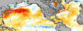
- 688 replies
-
- 4
-
-
- heat
- thunderstorms
- (and 7 more)

