nrgjeff
-
Posts
4,253 -
Joined
-
Last visited
Content Type
Profiles
Blogs
Forums
American Weather
Media Demo
Store
Gallery
Everything posted by nrgjeff
-

Fall/Winter Banter - Football, Basketball, Snowball?
nrgjeff replied to John1122's topic in Tennessee Valley
Crossville. Always. no matter what you're chasing. Snow. Tornadoes. Earthquakes? Just anything. Belated Merry Christmas and Happy New Year! We were in warm Puerto Rico. Kids had fun. We had sun. I miss the bright green landscape down there. -
Fall/Winter Banter - Football, Basketball, Snowball?
nrgjeff replied to John1122's topic in Tennessee Valley
Molten lava is bad for snow, haha! Volcano is a fountain kind, not the blow crap into the stratosphere kind. Probably no impact either way. Getting back to stress-free snow from the main pinned thread. Southeast Tenn had a fairly obvious one in 2015 I think Feb. Cold air was in place and moisture eased in from Alabama. Since then it's all blood sweat and tears - mostly tears. -
December 2023 Mid/Long Term Pattern Discussion: Let it Snow!
nrgjeff replied to John1122's topic in Tennessee Valley
Basketball metaphors are how to wake me from a coma. Asia cold is in full swing right now. China and both Koreas snow cover is much above normal. Nasty Siberian airmass is over China. High press is very robust. Nothing of note over North Ameria at this time. However some models at least jostle the Strato PV. This would be a case of working bottom up. We would look for the Urals / Scandanavia high press (esp 500 mb ridge not shown) to retrograde toward Greenland. We'll see.
-
I'll take cold rain for $400. Actually there's potential. We got a ton of family stuff this weekend, so my interest is zero. Cold season South.
-
Day two of LOW overcast and I already want to hibernate. The next few days look like crap too.
-
Fall/Winter Banter - Football, Basketball, Snowball?
nrgjeff replied to John1122's topic in Tennessee Valley
GFS and ECMWF both have severe Sunday Dec. 10. Normally that'd fall apart. However it's family nut-buster, um I mean Nutcraker weekend; so of course, I'll miss visible tornadoes in the South. I should have a better attitude after the big KU win over UConn. However it's LOW overcast day 2 in a row and I'm salty. -
Those trends are helpful. Unfortunately the IOD is going the other way on us. I expect many more crappy cold rain days like today.
-
Fall/Winter Banter - Football, Basketball, Snowball?
nrgjeff replied to John1122's topic in Tennessee Valley
CNN article looks more like a tighter PV. Climate change calls for a looser one. CNN -
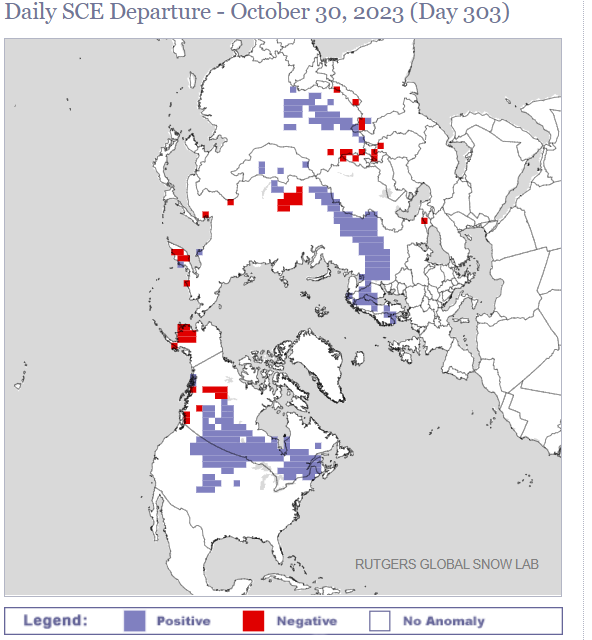
Looks mild until Christmas. Let's hope the cold is not 2022 style at Christmas. I'm dreaming white - not (rolling) blackout, ha! Pressure and Heights over the Arctic and Siberia are a warm signal for a few weeks now. Northern Hemisphere snow cover is too (Rutgers charts). Slight AN Mongolia to Manchuria, but Kazakstan and Canada are meh. If all else fails I have my alternate lyrics for Christmas in Dixie by Alabama and others. Christmas in Dixie, tornadoes in the pines.
-
Yeah I had to pinch myself. That really happened?
-
Fall/Winter Banter - Football, Basketball, Snowball?
nrgjeff replied to John1122's topic in Tennessee Valley
Good morning everyone. @PowellVolz I know cancer is scary and never routine. Sounds like they caught it early which is good. Thinking of you guys and praying for successful treatment. No praying emoji? Seriously AmWx! In lighter news Tennessee and Kansas play at 2:30 Eastern today. That's pretty early out in Hawaii. Guess they can be friends and go to the beach later! I was hoping to meet in the Maui Final, not 3rd place game. Should still be fun. If KU plays as soft as we did vs MQT then UT should win. Tennesse put up a better fight but that Purdue big is impossible. -
Monday November 20 is Outlooked. If the warm sector doesn't get a lot of rain, it has potential. SPC isn't too excited about instability, but it's shear season. Speed and turning from 850 mb to 500 by is quite impressive. Mid levels are not THAT warm. Any sunshine in the warm sector should achieve what little CAPE is required this time of year. Yes I'm a few days earlier than I normally post. But the weather has been quiet, the Champions Classic has been played, and I really need a new distraction right now.
-
Fall/Winter Banter - Football, Basketball, Snowball?
nrgjeff replied to John1122's topic in Tennessee Valley
Champions Classic was indeed a classic as usual. Kansas and Tennessee have both started seasons well. We might meet in Maui! -
Switching to 500 mb to catch the Ural Mountains ridge. One can see it in the Siberian snow cover chart too. Mongolia to Manchuria snow cover is building. This is long-term thinking, not the cold I infer from the mid-term thread. That Ural ridge could retrograde to Scandanavia. With GoA trough that'll pump warm air to the pole. Then after a warm December maybe break the PV. Or climate trend blowtorch - wake me up in May. But if the mid-term cold does not disappoint, I might believe.
-
How did you get interested in following the weather?
nrgjeff replied to Carvers Gap's topic in Tennessee Valley
I can't remember an age I did not love a good storm. Certainly by 2nd grade my career was set. I'm told I was fascinated by the Great Flood of the Country Club Plaza in KCMO 1977. I do not really remember it; only read articles later. Likely the flood planted the seeds before I could remember. Ironically flooding bores me like watching someone else derive calculus, that I don't need to know for a test or anything. I want wind, hail and tornadoes! John Hope got me interested in hurricanes mid to late 80s. My love of snow would probably be there regardless. Who doesn't' like snow? I don't chase snow or hurricanes. Snow is more fun when it comes to me, esp the challenge in the South. I'm not interested in structure only either. I want tornadoes! -
Yeah @fountainguy97 that's pillars from auroa. Twitter was lit up with debate. Does that count? I say anything cool counts at being cool! Canada has true aurora with the green curtains dancing etc. I inferred from Twitter and a Discord server nothing naked eye vis in the South. Probably true but your wx cam didn't have to dig hard. That's not a real long exposure? If it was naked eye visible, I'm going to.. Book reservations to Alaska!
-
I'm thinking Nino forcing finally makes a stand. MEI would hint at something less than strong from the pure ENSO, which would be helpful in many parts of our Region. For temperatures. Roll a pair of dice. Or see Winter Spec. I actually found a bullish story this week (for now at least).
-
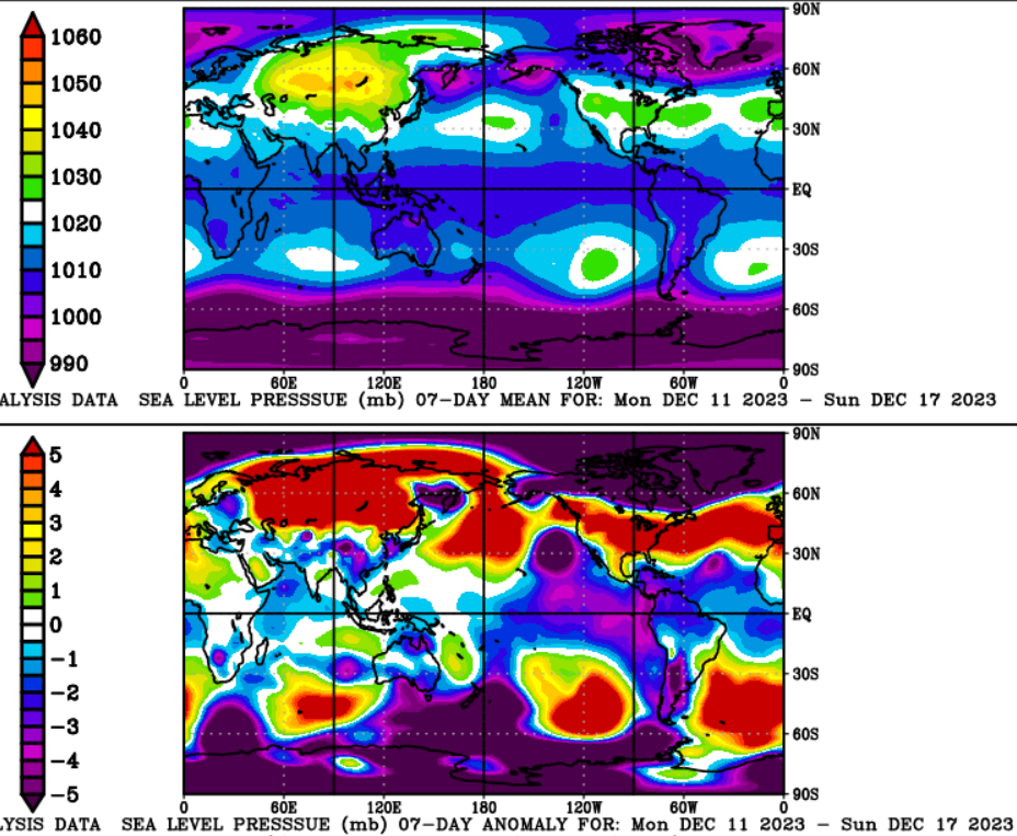
SST trends are somewhat encouraging RE the PDO. Snapshot still isn't great, but the trend. (not shown) And look what's back. HP at the pole. Even better, it's driven by a Ural Mtns high. Then the snow pattern is doing what one would expect. Ural high. Stormy south of Siberia. I love it baby!
-
To those wondering about November surface T forecasts. This is a mega-ensemble CFS/GEFS/ECMWF weeklies. I'm sorry if it violates the hate speech rule. Warm and totally uninspiring.
-
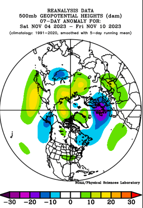
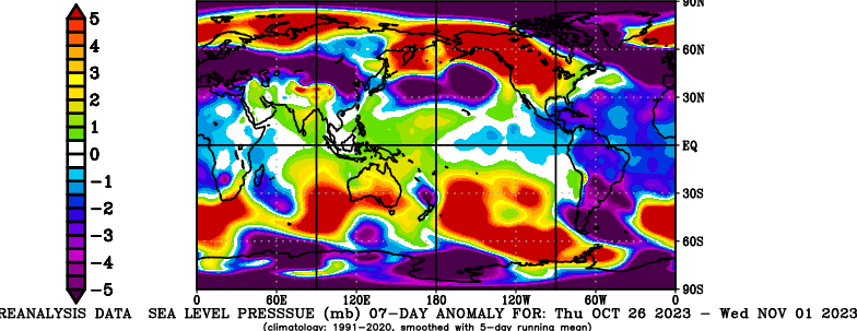
Unfortunately my Halloween post turned out not to be a treat. Pressure chart shows trick-f**k. That's a mild signal. Siberia Alaska HP runs its course. Top of the Pole is already LP - mild signal.
-
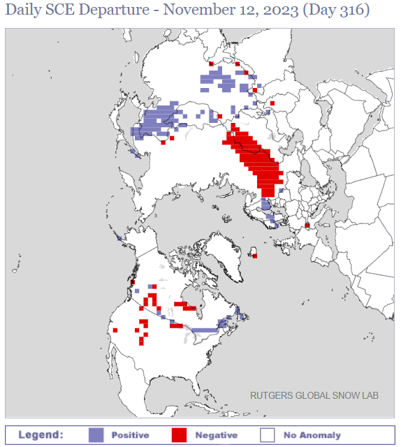
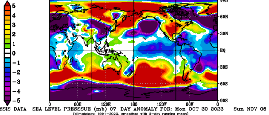
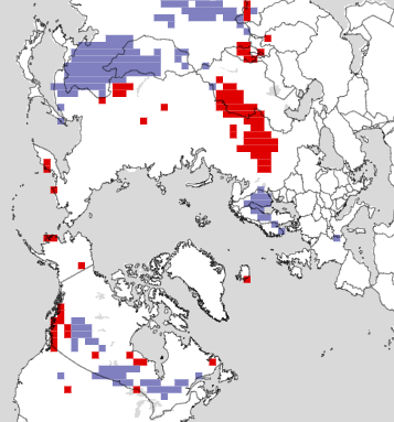
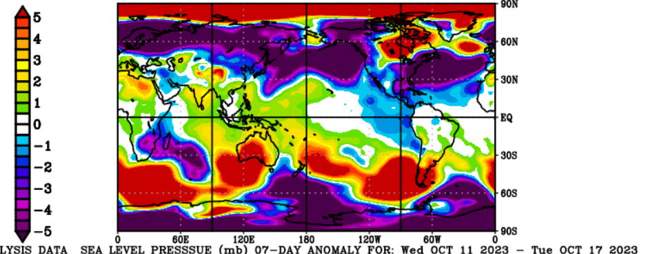
Rutgers snow chart has me about has happy as I was when Kansas beat Oklahoma. Winning! Sea level pressure (not shown) is AN in Scandanavia, Alaska, and eastern Siberia. Also helpful BN in mid-latitude China.
-
Cold forecast for Halloween has a good track record recent years. Kids trick-or-treat. Parents drink more to feel warm. Rinse repeat.
-
Need to bump one of John's thoughts. I think I first put this in the wrong thread. October does not have much correlation with winter. November definitely has a nice significant correlation with winter. It's not perfect, but odds are with November. Then in the longer-term, starting to get the look in the Arctic. AN surface press could deliver mid-latitude cold.
-
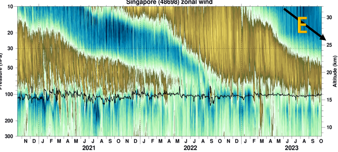
Well it's below 30 mb which is encouraging. Head fakes (2019-2020 fake is not shown) typically die above there. Fingers crossed.

-
Need to bump one of John's thoughts. First mine, October does not have much correlation with winter. November definitely has a nice significant correlation with winter. It's not perfect, but odds are with November.