nrgjeff
-
Posts
4,261 -
Joined
-
Last visited
Content Type
Profiles
Blogs
Forums
American Weather
Media Demo
Store
Gallery
Everything posted by nrgjeff
-

Summer-Fall 2024 Weather Disco Med/Long Range
nrgjeff replied to John1122's topic in Tennessee Valley
Tis the season for high-resolution models to be clueless. Today the rain was supposed to be MS/AL. It's Tenn. Love it!- 688 replies
-
- 5
-

-
- heat
- thunderstorms
- (and 7 more)
-
Summer-Fall 2024 Weather Disco Med/Long Range
nrgjeff replied to John1122's topic in Tennessee Valley
Wake me up when September comes.. Green Day is timeless. This thread should probably be pinned. Drop the pin on the Spring thread and put it out of its misery, ha. Still looks like we can avoid major heat for a good chunk of June. The more weeks we chop off the less miserable summer overall.- 688 replies
-
- 3
-
-
- heat
- thunderstorms
- (and 7 more)
-
Apparently West Tennessee had some landspouts over the weekend. I have seen few if any pictures on social media, but MEG did address questions.
-
Looks more and more like we'll escape major heat for a good chunk of June. We're all mentally prepared for a hot July and August each year; so, I'm not too concerned about those months. Yeah September nights get cooler. The lower sun angle also takes off the edge even during the day.
-
Any delay of the inevitable SER is welcome. Next week looks slightly warmer than normal, but the split flow variety so nothing too brutal. Also more precip. About a third of the way into June, a big ol' bowling ball of an upper low is progged over the Great Lakes with BN heights into the Valley. We've seen that before in June. AI versions of the ensembles concur so that's good. Eventually the Nina influence will rear its ugly head. I'm afraid a back-loaded summer would drag deep into fall. Closing on a positive, the weekly products are not in a rush to set up the SER.
-
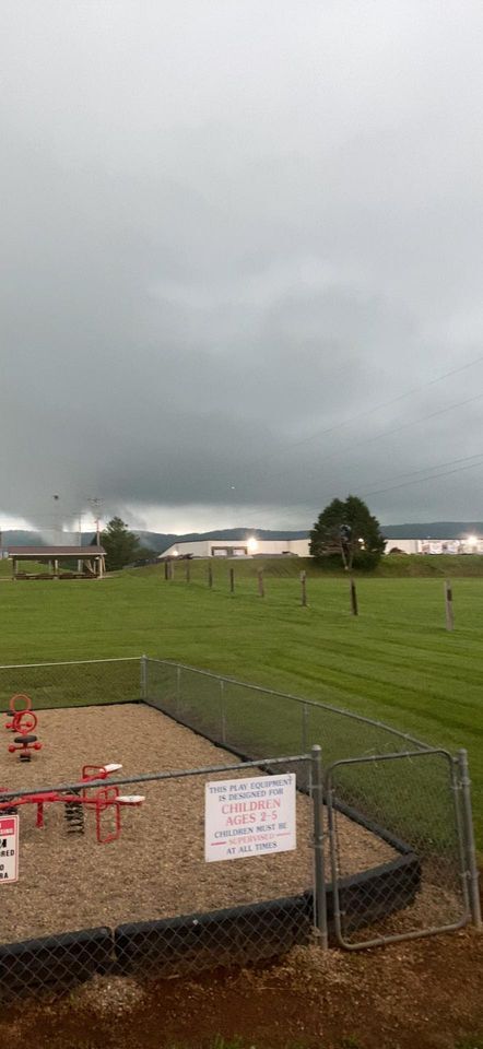
Weather went about as I expected for three Marginal risk days. We had thunderstorms. Not many were severe. Some were strong. Chattanooga got a good light show or two also. Sunday is a true Slight Risk with Enhanced north. Most of us will probably see morning and then overnight storms and straight wind. Enhanced area might be more interesting Sunday afternoon but rotation is conditional on how the outflow behaves. It's a good Enhanced for wind in my opinion. Monday things depart. How about a mid-Atlantic Slight? Watch the best storm of the week be east of the Appalachians, lol!
-
Today Northern Illinois into Chicagoland Atmo might be too overturned from the midday MCS. Models that have a robust round 2 later handle the morning MCS poorly, and one simply didn't even initialize it. Back along the Mississippi River could be a different story. As for Chicago, I'm looking forward to midday shelfies with the skyline. Sunday is my main interest. Could start out with a raging MCS too. Difference is that Sunday is a stronger system. After the MCS a second short-wave is progged by most models coming in toward 00Z. Early MCS should leave outflow boundaries. Some will drift south of the synoptic WF and such OFBs would be my main interest to a point. South of I-64 will get away from the best upper support and into questionable terrain. SPC also favors such outflow boundaries for their Sunday Enhanced risk corridor, which I interpret from the WF down to the OFBs. Could also be the most wind reports later. Lincoln, IL mentions the outflow boundaries kind of in passing before getting to the red meat part of the forecast discussion for Sunday. Lincoln, IL discussion looks good for Sunday. ..Forecast soundings (NAM/SREF) Sunday show long, cyclonically curved hodographs along with very steep (>8.5-9.0 C/km) mid level lapse rates supportive of supercells and large hail. 0-1 km bulk shear of 15-25 kt and high SRH (>200 m2/s2) are supportive of supercell tornadoes. Storms should become linear with time with wind then becoming the primary hazard.
-
Oh yeah the Wednesday evening storms looked nasty up that way. Thursday not as bad? Same boundary is hanging around Friday but lacks robust upper-level support East Tenn. I think West Tenn atmo is too overturned but there's modest upper flow that way. Attention shifts to Sunday. Outflow could get all the way into our region, though SPC has lifted that north with the models. I figure the tornado risk is north of the Ohio River on the warm front Sunday. I'll visit the Oho Valley region to discuss Sunday in more detail. Sunday night the cold front should provide a chance of linear storms here in the Mid-South and Tennessee Valley.
-
Subvorticy party. That's the most classic example I've seen on video. Looks straight out of the Dr. Fujita textbook. He'd be smiling down if ppl did not succumb to their injuries. We'll just go with, he's vindicated once again.
-
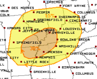
for Sunday: Although the 30% is Mid-South, the surface low and associated boundaries could very well be Illinois to Indiana. I'd love the WF to be north of I-70. At least I-64. Outflow will likely be in the Mid-South but that's hideous chase terrain. If the atmosphere can recover from morning rain and storms, instability should get north into IL/IN which is already 15%. SPC could be waiting for confidence on Atmo recovery and then destabilization farther north. Their 'concerning pattern' language is notable.
-
Wednesday through Friday we have that meandering boundary across our region with modest flow aloft. Mid-South to West Tenn have Slight risks Wed/Thu. Marginal covers much of our region. Timing short-waves and some low-level winds will determine whether storms are garden variety or something more. Then on Saturday a new system develops in the Plains and ejects east for Sunday funday. Mid-South is the focus with some through much of our region. SPC looks at concentration. Low pressure may be up in IL/IN along with the warm front and triple point. Depends on previous days precip. We'll see.
-
They are trying. AI versions and weekly products concur. We'll take it! The progression is logical after the series of Plains and Midwest troughs perhaps sets up a little Great Lakes trough. If we're lucky the trough axis would include the Tennessee Valley. Unfortunately it won't last long. I'll enjoy any mild weather we can get, because I'm concerned it'll be a true Southern summer.
-
I prefer the discrete cells shown by the RRFS and FV3. HRRR and ARW have red bows. Edit: no reason to quote for continuity. Posts are only minutes apart. Looks like the Derecho checklist won't be met. We will have the west-east boundary and moderate theta-E. However the height falls are not met. Also 700 mb is more classic CAA than the WAA associated with derechos. 850 mb is neutral-ish and probably why CAMs can't make up their mind bow or sups. Why am I hoping for sups? I'm like the only storm chaser not in the Midwest or Plains this week, haha!
-
Southern Iowa convection appears to have spit out a differential heating boundary into northern Missouri. 10:30 am Central visible showed it through Kansas City, but the target will be farther northeast. 10:15 surface chart shows differential heating around I-70 in Missouri. Hard as it is for this Jayhawk to say, Missouri has some things going for it. The mid-level and upper-level flow crosses the surface front and pre-frontal trough better than farther north. Yes a subtle wind shift is forecast in Missouri ahead of the main front. Next storm motion will be slower in Missouri. CAMs keep some cells discrete in Mizzou likely related to the cross boundary flow aloft. Key is for the little outflow along I-70 to stay intact as it lifts north. It will lift north in this strong synoptic pattern and no rain in northern Missouri. I would chase the intersection of the lifting boundary and any pre-frontal trough. While it's a mess south of I-70, Missouri terrain is chasable north of I-70.
-
I think we need dates on this thread do differentiate it from the general severe wx topic. @jaxjagman will it still let you edit? Wednesday we have that boundary likely settling over the Mid-South. Upper flow is modest at best, but sometimes that's all it takes in late May. Thursday needs that 15% into West Tenn. Probably depends too much on Wednesday. However what I see is a residual outflow under decent upper-level flow. Friday could be farther north; or, the boundary gets stuck in the Mid-South again. Moderate flow (more than Wed/Thu) ejects from the southern Plains. Saturday and Sunday switch back to synoptic pattern recognition. Saturday has the next Plains wave. By Sunday it's forecast over our direction. Yet another Monday is possible. All of this feels too late in the season, but a check back at the records indicates it's not. Guess that's one reason I'm not in the Plains this week.
-
Tue. May 14 That's a boundary intersection with modest flow aloft. 15% for wind and hail. 2% Tornado into Middle and East Tenn.
-
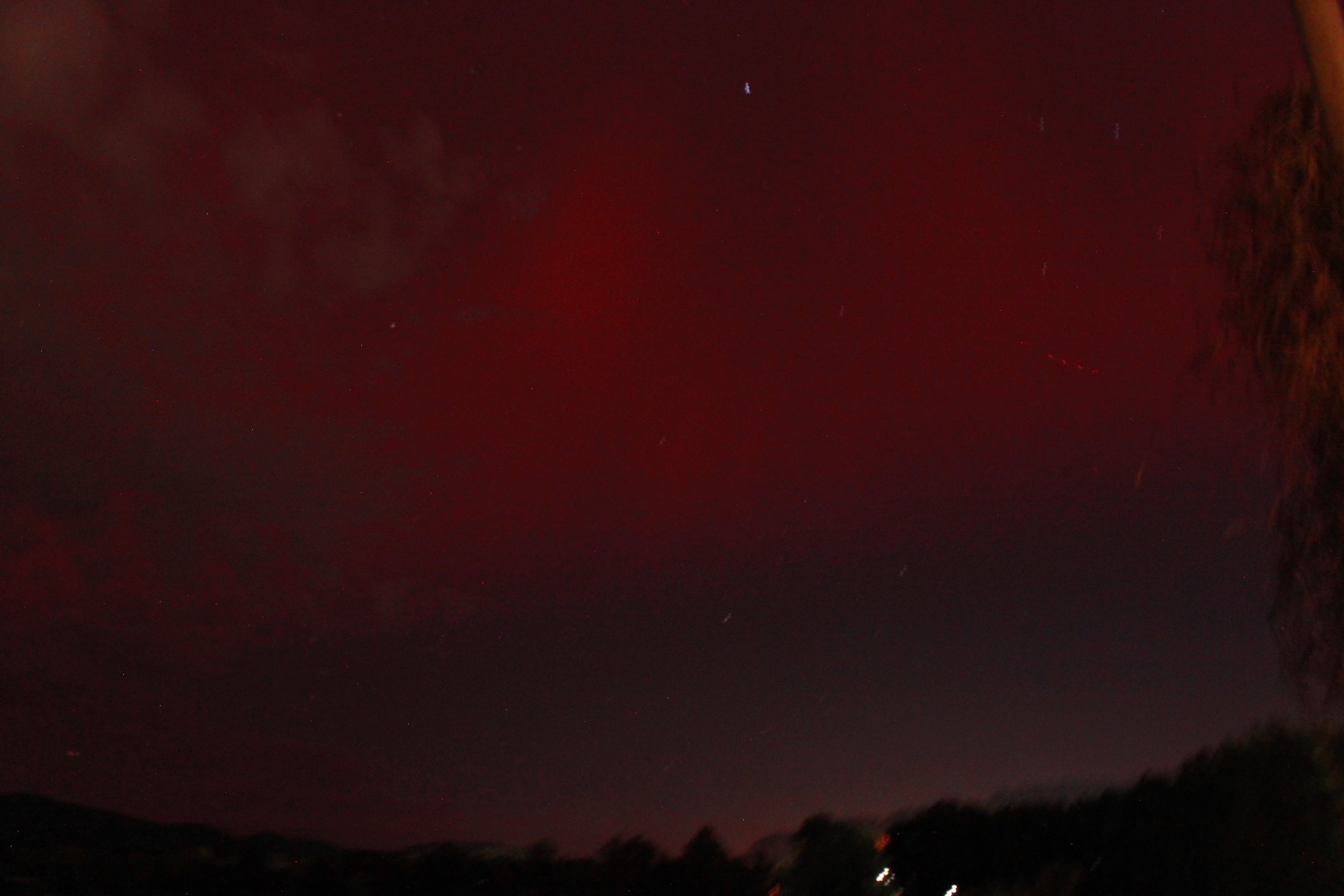
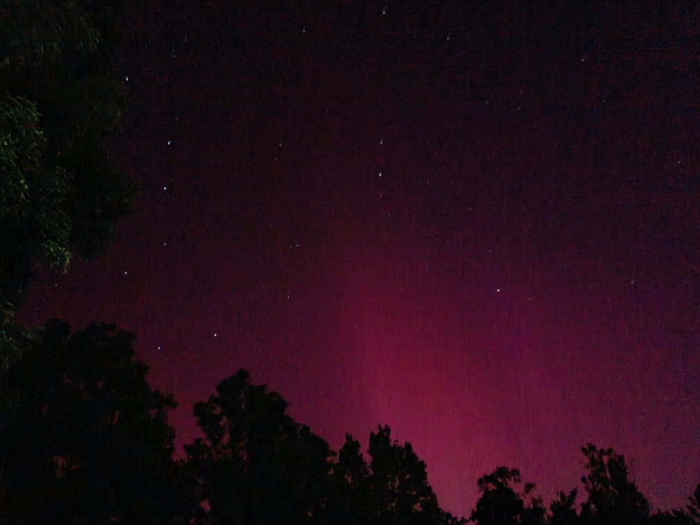
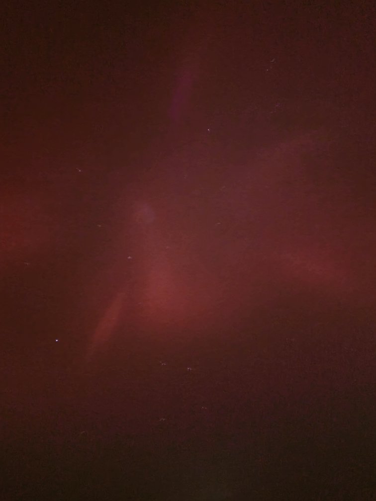
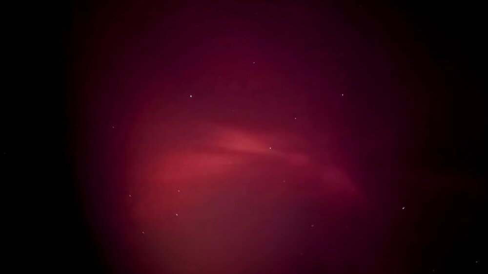
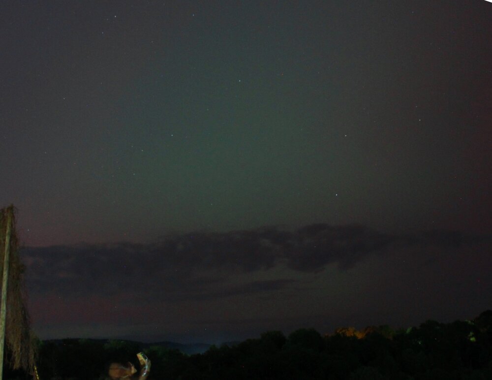
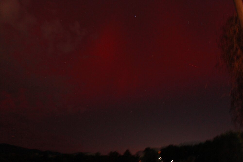
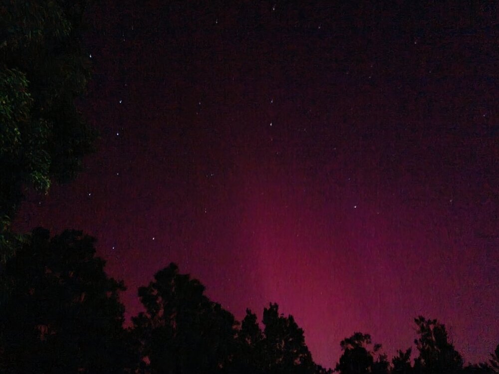
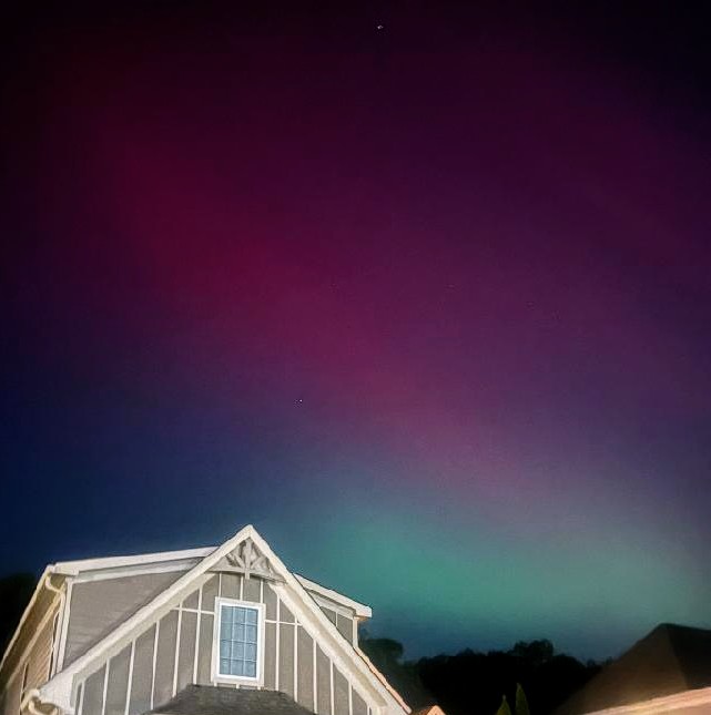
Lets see your Friday night lights! I told family to expect a little DSLR fun on the horizon. Manage expectations. Wife and kid are getting into photography. Comet Neowise planted the seed. We didn't attempt technical Photography for the Eclipse. Oh but an Aurora in the South is exactly the time to use a camera! We headed out to a rural area because I had no idea it'd be visible in town. Or you know, in Florida! I was thinking 40 deg. N best case and we ain't there. Well, geomagnetic latitude we are, but whatever. I was not expecting what happened. Got to get gas and I could see green northeast from the bright gas station canopy! We found a suitable semi-dark spot. No time to find perfect in a small town I don't know. Williamsburg, KY very friendly but not dark, ha. We settled for a building with no lights in its parking lot. Some of these pics are from there. Then the neighbor took one of it hitting our house, lol! Highlights are starbursts and the like Overhead! Aurora all-quads also has a nice ring to it! It was absolutely in the southern sky too. We had much better naked eye traveling than staying in town. Sharing with family was meaningful vs my usual chase partner (sorry dude). What a blessing!
-
- 6
-
-

-
- aurora borealis
- northern lights
- (and 4 more)
-
My eclipse and aurora season is going much better than my storm chasing. Aurora pix pending transfer from DSLR. For now, this lovely stat.
-
Something new to be hopeful for. Sky conditions will be excellent. Whether anything shows up this far south is a different matter.
-
The light show was next level all night in Chattanooga. @*Flash* very nice job with that chase in dreadful terrain. Post is previous page.
-
This is old but still relevant. About that time the finally went 15% tornado probs. Southeast Tenn. Goodie at night! Then at 10:12 pm Eastern Time. Everything is kidney bean or hook. Just wow!
-
The South is so much fun after dark, but not the weather. Seems like it's escalating juuust a bit.
-
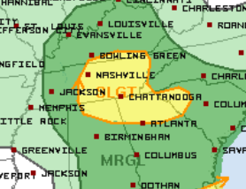
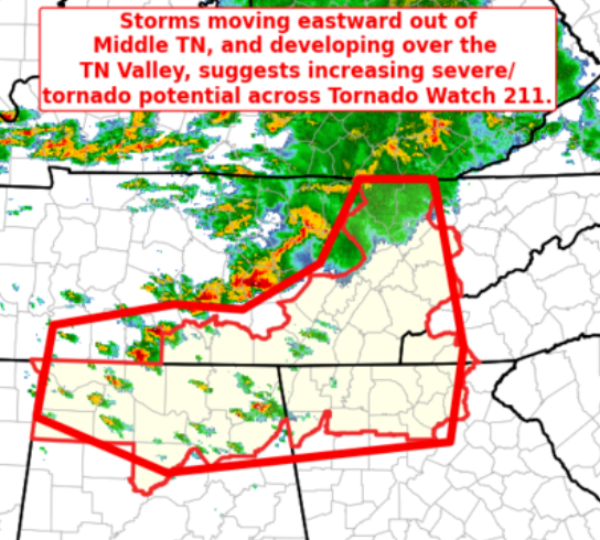
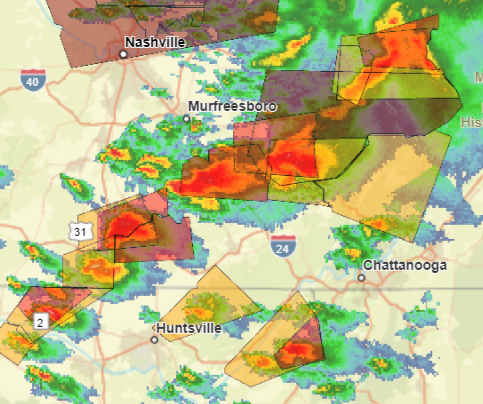
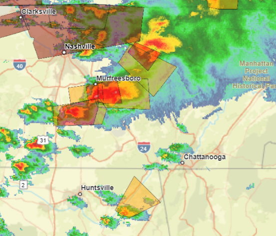
String of pearls shows little sign of congealing into a line. Oh yeah, we're in the South. We do our tornadoes at night! Normally that doesn't make it over the Plateau. Tonight unfortunately we have Great Plains parameters in place, so.. Remember southeast Tennessee tornado watch until Midnight Eastern. The cell just south of Murfreesboro caused the damaging tornado earlier. From just issued Mesoscale Discussion #716. Parameters are for the vicinity of the line of pearls. New watch will be Western and Middle Tenn. The airmass across this region remains very unstable, with mixed-layer CAPE in the 3000 to 4000 J/kg range. This should be more than sufficient to sustain vigorous updrafts, support CAM runs which increase convective coverage over the next several hours. Strong deep-layer winds will support organized convection, with an all-hazards severe risk likely to continue through the evening and into the overnight hours -- warranting new tornado watch issuance across this region.
-
Still no squall line. Just a string of pearls as the LLJ cranks up at dark. Oh yeah, we're in the South! Goodness I almost forgot. Those usually won't make it across the Plateau into Chatty. But we usually don't have Great Plains parameters in place. Oh goodie!

-
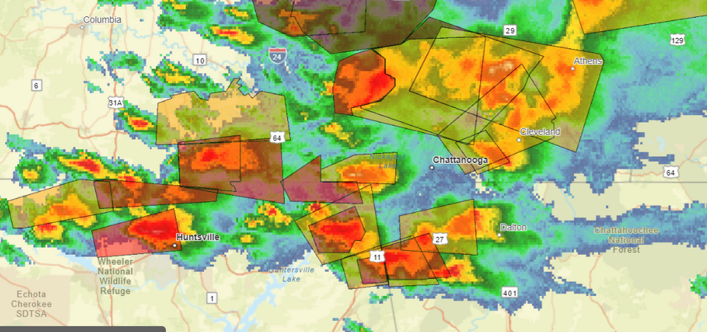
WBIR viewer Rutledge, Tenn. I believe this morning. While it has a scuddy look, I lean TOR. It's all by itself. I infer inflow from our right. It's in the correct part of the storm base. Quick note about Southern Tenn. Outflow has clearly detached from the warm front. RRFS picks up on southern Tennessee storms later.