nrgjeff
-
Posts
4,251 -
Joined
-
Last visited
Content Type
Profiles
Blogs
Forums
American Weather
Media Demo
Store
Gallery
Everything posted by nrgjeff
-
Epic model failure! How a cold forecast goes torch. I'm out until spring severe. Except Banter, always college basketball.
- 750 replies
-
- 6
-

-
- snow elk
- wooly worm
- (and 1 more)
-
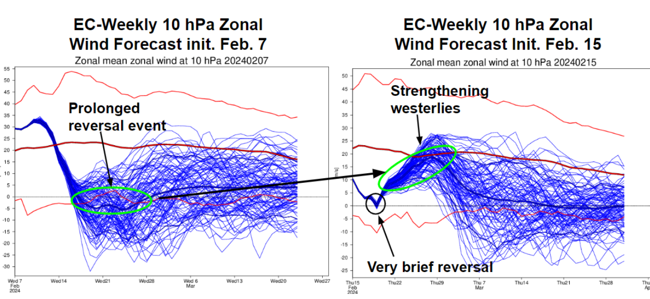
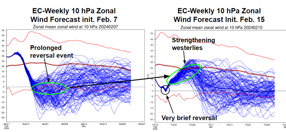
Looks to me like the Strato warmings cannot connect with the Troposphere. Modelling for late February was a total bust. There is some hope in early March, but that gets toward mid March. No true connection with Canadian air either. We would have to hope for a bowling ball. They can and do happen that late. If this does not work I'm ready for severe early and often.
- 750 replies
-
- 6
-
-
- snow elk
- wooly worm
- (and 1 more)
-
Good to read reports of lightning and thunder. We can settle the mid-term debate in the pinned thread. Snow before the season ends!
-
Indeed @Itryatgolf70 this unusual combo of -PDO and El Nino has been fickle. It's how we get a great storm track, but putting cold air in place is like pulling teeth - without Novocain.
- 750 replies
-
- 4
-
-
- snow elk
- wooly worm
- (and 1 more)
-

Fall/Winter Banter - Football, Basketball, Snowball?
nrgjeff replied to John1122's topic in Tennessee Valley
Cold core setups do weird things, but often photogenic things. Saturday on the hardwood Eve. Tennessee goes on the road in what's pretty much a must win game. Gotta get Ws on the road. Kentucky will win hosting Gonzaga. Kansas will win hosting Baylor. Alabama and Auburn are both on the road. I have no idea. Couple other Big 12 games that might be interesting are TCU at Iowa St. and Oklahoma bedlam. -
The Indo-Pacific is a mess. Convection that has come east from the Dateline is old news. Thunderstorms percolating over the Maritime Subcontinent (Indonesia / Malaysia) are a warm signal (current pattern) that was supposed to move east into colder phases again. Ope! Got new convection blowing up in the Indian Ocean. As it marches east it gets into the warm signal Maritime Subcontinent again. MJO models are not as messy as the reality I see on satellite. I suspect weather models will continue to struggle for North America. At least the southern storm track looks active.

- 750 replies
-
- 2
-

-
- snow elk
- wooly worm
- (and 1 more)
-
January Medium-Long Range Discussion
nrgjeff replied to Holston_River_Rambler's topic in Tennessee Valley
The next snow is always 3 weeks away, kind of like the next Kansas road win. -
Fall/Winter Banter - Football, Basketball, Snowball?
nrgjeff replied to John1122's topic in Tennessee Valley
South Carolina played dirty, but UT needs to play through that. Oh I have my own problems. Kansas may look invincible at home, but can't win against Q3 on the road. As for the NCAA I've long called it Nazi Commies Against Athletes. It's corrupt, power hungry, greedy, and doesn't want to share with the athletes. -
Fall/Winter Banter - Football, Basketball, Snowball?
nrgjeff replied to John1122's topic in Tennessee Valley
I thought Kansas was inconsistent. Then Kentucky is like, hold my beer! Tonight Alabama and Auburn should be interesting. Hopefully high scoring. So Tennessee has the whole week off? Should be well rested for Saturday. -
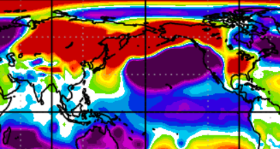
Big ol' Siberian high invaded China. They have racked up above normal snow cover now. High press extends over the Pole to Alaksa. However a big ol' GOA Low is grinding away. Could get cold again in 2-3 weeks. Fow now, Hurry Up And Wait!
- 750 replies
-
- 7
-
-
-
- snow elk
- wooly worm
- (and 1 more)
-
Yeah that's a dubious stat. Anytime from the late 60s to early 80s we had the -PDO and -AMO which is ideal for low latitude winter storms. Basically dig the jet stream south coast to coast. I agree with @John1122 something is awry. I'm on board with the consensus climate science, but the community must do better with so-called data quality control. Stuff like this seeds doubt in the data, and then doubt in future predictions. Burden of proof is still on us scientists, even if we're very confident.
-
Fall/Winter Banter - Football, Basketball, Snowball?
nrgjeff replied to John1122's topic in Tennessee Valley
Tennessee is ranked above Kansas this week! KU has played a couple dreadful road games. Tennessee really handled Alabama. Yeah it was at home, but the Vols would have smoked them on the road playing that well. Kentucky shows some high-power offense like we have not seen in a few years. Defense is TBD. Auburn could also make a statement in the SEC. Some of the best weeks of the year are upon us. Time to dig into the heart of college conference basketball season! -
January Medium-Long Range Discussion
nrgjeff replied to Holston_River_Rambler's topic in Tennessee Valley
Looks like a mild two or three weeks. Two weeks straight warm is tough to do this time of year. Perhaps a pair of 5-7 day warm periods with a cool sandwiched in between. High latitude ridging has sloshed back and fourth between Greenland and Scandanavia on a 4-6 week cycle since Thanksgiving. We'd be due for another cold period the back half of February. Cold wouldn't have the punch after 15 Feb. However it could get cold enough for winter precip. Honestly I could use the break now. Enjoy some Conference college basketball as we dig into the heart of the conference season. -
January 15th-17th 2024 Arctic Blast/Snow Event
nrgjeff replied to John1122's topic in Tennessee Valley
Last visit and post for the night. @Chattownsnow and @Uncle Nasty I think the chart above from @TellicoWx eases the Chattanooga anxiety a little bit. We should be able to avoid a Dallas Cowboys style melt-down. I'll feel better when I see snow falling. Warm air is hanging tough in KCHA but we're always the last to cool off. Already snowing in Knoxville. LOL Chatty. Back to the game! -
January 15th-17th 2024 Arctic Blast/Snow Event
nrgjeff replied to John1122's topic in Tennessee Valley
No I think you're OK. In fact that forecast is so nutty that I should feel better down here too. Cynicism aside, this snow event should work out. Pattern recognition is that the reinforcing Arctic front will anchor the cold. Isentropic lift with mid-level front is near ideal. NAM has its strengths with robust waves, but this isn't that. I may eat my words, but I think everything will work out. PS the Paul Barys post shows up now. Yeah that is about what I'm thinking locally. Time to relax for a bit. I'll be back later. -
January 15th-17th 2024 Arctic Blast/Snow Event
nrgjeff replied to John1122's topic in Tennessee Valley
KCHA Dew is 28. It should fall as the reinforcing front settles in over the Plateau. CAA is fighting downslope right now too, see the dry bulb 44. Both should improve at dark and as the cold air settles in over the Plateau. That said, this is Chattanooga. We have suffered many instances when what looked like a good wet bulb setup failed. We'll find out a lot this evening when precip starts falling enough to impact the low-level profiles. Rather than going neurotic in Chatty, I'm gonna watch this football game for a while. At least until half-time. Unless I check at the next commercial, lol! What did Paul say? Is it gonna piss me off or make me happy? -
January 15th-17th 2024 Arctic Blast/Snow Event
nrgjeff replied to John1122's topic in Tennessee Valley
Beginning of precip will provide much needed information in Chattanooga. See were our wet bulb and dry bulb go. I'm pouring a drink. Will we toast in happiness or rage drink? -
January 15th-17th 2024 Arctic Blast/Snow Event
nrgjeff replied to John1122's topic in Tennessee Valley
Chattanooga is going neurotic which is understandable. We suffer severe snow choke trauma. High-res models refuse to drop the front like the Globals. Could be initialization. KCHA was 45 at 18Z. Dew of upper 20s cuts it close on the wet-bulb. I think what's happening is the usual daytime front (reinforcing shot) CAA struggles to overcome downslope off Plateau. Chatty just needs the cold air to settle in tonight despite clouds. I believe it was Feb 2015 when a lovely isentropic setup came in from Alabama. It over-achieved. IIRC 2014 was a bowling ball. 2020 definitely was a bowling ball - more like a quidditch ball. The last cold air in place for KCHA was 2015. So, Chattanooga will either return to glory or choke on our tears. Rapid Refresh F-bomb Sh-curse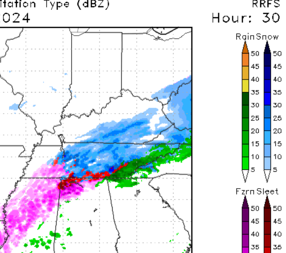
-
January 15th-17th 2024 Arctic Blast/Snow Event
nrgjeff replied to John1122's topic in Tennessee Valley
Some downslope warming is possible on the front side of the system. However I don't think it'd be a deal killer. Maybe cut rates for a couple hours. If it even happens, start snowing, ease up, then get back at it second half. Kind of like Tennessee basketball, ha! Otherwise, box to wire snow. -
January 15th-17th 2024 Arctic Blast/Snow Event
nrgjeff replied to John1122's topic in Tennessee Valley
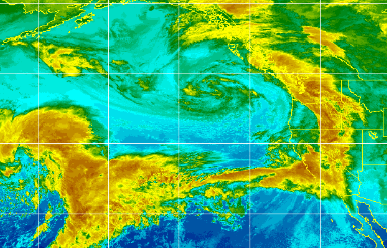
NAM seems a little off this setup. We got the gentle isentropic upglide we all been wishing for since 2015. Energy for our system is just getting onshore in the Pac NW. Looks like the 18Z NAM is a little south (John, Carvers posts above) and the NAM will get more of the Pac NW wave on the 00Z run. Hopefully the NAM will settle in with the Globals. I'm cautiously optimist about Chattanooga. Cold air should be in place. A brief mix is possible due to low level temps, but this feels like an all snow event. Energy sliding up from the Deep South with isentropic lift is hard for even KCHA to screw up. Fingers crossed Little concern elsewhere. Looks like a gem coming for much of us! -
January 15th-17th 2024 Arctic Blast/Snow Event
nrgjeff replied to John1122's topic in Tennessee Valley
Winter Storm Watch SOP allows up to 48 hours out. They're using all of it! 3-8 inches on a Day 3 forecast in the South. Though the Mid South would be the place to forecast it. Farther east I'm not particularly concerned about the NAM 60-84 hours. That far out the Globals should still offer greater value. I'm always concerned about Chattanooga, but not because of the NAM. -
Fall/Winter Banter - Football, Basketball, Snowball?
nrgjeff replied to John1122's topic in Tennessee Valley
Charts above are how to get proper snow across the entire Tennessee Valley including southeast Tenn. Take a break tonight for SEC basketball action. Tennessee leads off early. Georgia and Ole' Miss are both getting points at home. Kansas is on too, along with other Big 12. -
January Medium-Long Range Discussion
nrgjeff replied to Holston_River_Rambler's topic in Tennessee Valley
China is still cold, the surface high has settled in, and China wx/precip has quieted down. AN snow remains under clearing skies. US MIdwest has some AN snow. Otherwise the hemisphere is BN. Surface press is below. I see hurry up and wait on the next big cold push into the US. The seasonable cold South mild North should continue until then. Just with no really cold North source it's tough to be cold enough for anything good. See KCHA cold rain this am.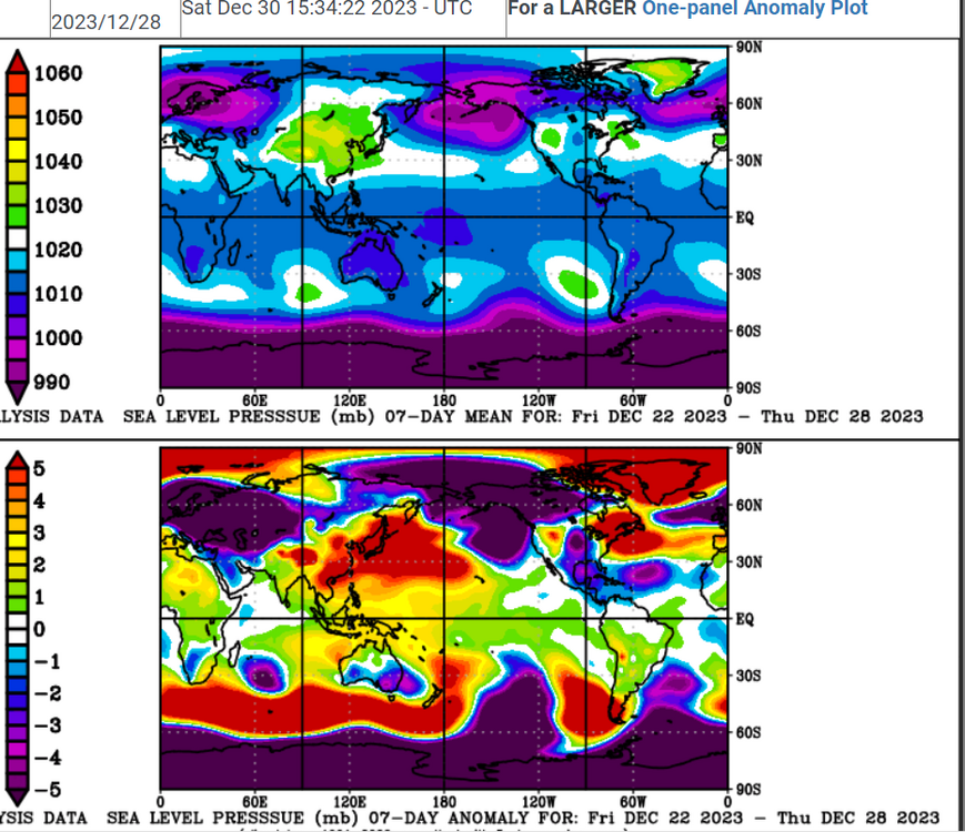
-
Fall/Winter Banter - Football, Basketball, Snowball?
nrgjeff replied to John1122's topic in Tennessee Valley
Crossville. Always. no matter what you're chasing. Snow. Tornadoes. Earthquakes? Just anything. Belated Merry Christmas and Happy New Year! We were in warm Puerto Rico. Kids had fun. We had sun. I miss the bright green landscape down there. -
Fall/Winter Banter - Football, Basketball, Snowball?
nrgjeff replied to John1122's topic in Tennessee Valley
Molten lava is bad for snow, haha! Volcano is a fountain kind, not the blow crap into the stratosphere kind. Probably no impact either way. Getting back to stress-free snow from the main pinned thread. Southeast Tenn had a fairly obvious one in 2015 I think Feb. Cold air was in place and moisture eased in from Alabama. Since then it's all blood sweat and tears - mostly tears.