nrgjeff
-
Posts
4,261 -
Joined
-
Last visited
Content Type
Profiles
Blogs
Forums
American Weather
Media Demo
Store
Gallery
Everything posted by nrgjeff
-
Before 11am @John1122 verifies. Photo Greg Williams a HAM / spotter in Crosville. May 8 Anywhere else I'd question it. On the Plateau, that's probably what it looks like.

-
Warm front is going to light up, and perhaps with supercells. It will start the day draped straight across Tennessee. You want daytime in the east? ECMWF and a couple high-res hang it up in Tennessee, which would be bad news. Most everything else lifts it into Kentucky before it goes berserk. Then of course overnight Wednesday night a huge red bow squall line is forecast to rake the state. Two rounds. We wouldn't do it any differently in the South!
-
Yeah I agree with Andy on Indiana above. Illinois boundary right now enjoys more instability. However Indiana convergence zone will have a ton of SRH. Plus it'll destabilize too. I have always preferred the eastern of two surface troughs when chasing east of the Mississippi River. Midwest, Mid-South, Deep South. Then more upper level support is over Indiana. Need to catch the right entrance/rear of the upper jet, which is somewhat departing Illinois. Now there's a Plains short-wave coming out, but that is the overnight stuff. Daytime I think Indiana. LLJ also hangs in better Indiana vs Illinois.
-
The 2% on Monday verified in Tennessee, but most of the tweets are scrubbed. Also possible she blocked me for political reasons. Layperson not media. Today we have 0% strong in North Bama. Very subtle boundary is trying to lift north. Outflow from Mid-South is oriented NE to SW; and, they may intersect later. However the LLJ is modest to meager. CAMs fire it, but it could just be blobs. SPC coveres farther north. Wednesday is the classic outflow boundary day. Models verbatim have it lifting into Kentucky, which looks reasonable with strong enough WAA. If greater precip coverage in the morning, the boundary could get stuck in Tenn. Right now only the Euro has that.
-
Yes I agree with Tuesday 10% centered around Dayton, straddles IN/OH border. From what I recall driving to Detroit, that's quite chasable territory. LLJ is forecast to be roaring into the vicinity. Right Rear/Entrance of jet streak should promote lift. The morning stuff is going to be on the Left Front/Exit. Right entrance is sometimes fickle, but an excellent boundary will sit underneath it. Tuesday looks like a classic outflow re-generation day. Then on Wednesday it could be anywhere with the rain enhanced boundary sinking south. Unfortunately, it looks like it could be Kentucky which isn't great chase terrain. Though some open ag spots are available. Wednesday could also go berserk the northern half of the Mid-South MO/IL, but that's touch and go terrain. I'm not sure how one would position after Tuesday. Probably depends on how Tuesday goes, to position for Wednesday.
-
I'm gonna need that crap to stay north of the Ohio River. Mid-South will probably invade Tennessee Wednesday evening with straight line winds though. So long as the WF or rain enhanced outflow boundary does not get into Tennessee - stays Ohio River Valley - (most of) the tornadoes should stay up there too. No reason to hype the Tennessee Valley. It's actually still peak season, early May is just more late April; however, the synoptics situation favors the Ohio River Valley. Mid-South is kind of on the borderline. Again augmented boundaries could still play a role, but the synoptic situation overall is north.
-
Tuesday looks like the convectively enhanced outflow boundary gets down toward southern Illinois. It could stay farther north in Indiana or lift north there with greater LLJ help. At any rate 500 mb flow will be robust and with a shortwave coming around 00Z after the morning one departs. It'll probably convect late afternoon. Boundary intersection between lifting outflow and synoptic front or pre-frontal trough will be the area of interest. CAPE lurks ready to recover north with the said boundary intersection. Wednesday now looks like it may have the greater kinematics. Still robust 500 mph flow, with greater LLJ. The more true short-wave at 500 mb should promote a surface low response. Key is for the strength of the system to keep boundaries north of the Ohio River. North of I-64 would be preferred. Wednesday severe wx could stretch all the way from Texas to Ohio. I feel like we were just talking about this. Oh yeah the eclipse! Anyway Wednesday will probably be most interesting just east of the surface low. Placement is TBD after prior convection.
-
I think Tuesday could be a classic Illinois Indiana day. Impressive jet stream punches in aloft. LLJ goes Plains nuts over in the Midwest. And that warm sector CAPE! Wednesday looks pretty good too. Maybe the SPC thinks boundaries are going to push the warm sector back into the Mid South. I'd much prefer things stay up in IL/IN/OH and they may if a major MCC doesn't wash out everything Tuesday night. Thursday could actually end up in the Ohio Valley or Tennessee Valley, neither of which is acceptable chase territory, though the latter is close to home. If Tue/Wed satisfy, I won't care about Thursday terrain. Oh yeah I can't make it to the Plains for Monday, so figure I'll post here in Lakes Ohio Valley.
-
I expect parts of the Mid-South and Midwest to join the SPC Day 4-8 day outlook in the next day or two; so, look Friday or Saturday. It's wild how the Great Plains could get whacked Monday, then get quiet. Then the trough slows down to gradually work through the Mid-South and Midwest (IL/IN/OH). Each day a wave slides around the base and ejects out. LLJ responds. Kentucky could get clipped next week. Feels late in the season but it's not. Early May is still the heart of the season. Most of those states peak in May too.
-
It's El Nino with La Nina characteristics. Great Plains too.
-
Yeah transition into La Nina of course gets rolling first here in SER land. I'll see y'all when football starts.
-
Forget trade wars and tariffs. USA and China want a tornado war. Well, it's better than a military war! Indeed severe season has made the shift out to the Plains. If you are weather anxious here in the South, you can start to relax. Yeah, we have more of the season to go, but the wedge outbreak season is pretty much over in the South. Now we can still get plenty of mesoscale setups, and I intend to find them. I might have used up my kitchen capital on the eclipse, so a Plains trip is questionable this year.
-
I have no dog in the hunt, because my back-up is already on vacation not related to weather. I'm not chasing, but this should be a quality sequence. Thursday the morning rain eastern KS will kick out an OFB that should stay separate (south of) the WF. It's my preferred chasing scenario OFB DL intersection. No concerns upper levels. Thursday looks lit! Friday is farther east. I'd chase outside of the KC metro because I know the area. It is not jungle outside the city. Could be a wide area though. Depends on Thursday night. Saturday the true Plains relaods. Upper levels have a kink or two. However moisture will be deeper than on Thursday. Boundaries will be around. Saturday could be a day. Sunday is kind of Friday echo, but that far out we really don't know much after 3 days of convection. At any rate this looks like a true Plains sequence. Y'all at some point you need to decide to travel to the Plains. Waiting for the perfect set-up = never going.
-
Virtual starting point: Ottumwa, IA. Virtual starting area is from Oskaloosa IA to Kirksville MO. I'm not out there this week.Ottumwa is the north side hedge (2/3 of the way) for lunch and data. Easier to adjust south than north, esp fast storm motion. Goal is to position for either the warm front WF or outflow boundary OFB. Normally we like OFB, but Iowa loves to WF. Plus they may become one diffuse boundary with all the mixing and wind today.Cell northeast of KC (at 11am Central) looks like an OFB work but it's getting close to the WF. Said cell(s) will likely maintain or create outflow. I would position closer to the WF in case that's it. No way to catch up from the south; so, be north at first. If the OFB ends up being it, adjusting south or just waiting for it would be relatively easy. Either way a classic dry line DL is coming out of Kansas. It's not just a Pacific front; it's warm and dry behind it. Moisture ahead is deeper than yesterday. Really both WF and OFB, plus other minor boundaries, could deliver at their intersections with the DL.If the WF and OFB surge north the target might have to shift more into Iowa. However, if an outflow can anchor then northern Missouri is in play. Also, I know I'd chase east from the starting points above. IIRC all that terrain is OK. It's not Kansas, but it's not the Ozarks or eastern Oklahoma either. Good luck and be safe!
-
Down South we saw more cars like yours @NoCORH4L haha! New England you have the best eclipse thread so figured I'd stop by again. I'd switched to Ohio Valley, but we ended up viewing from North Arkansas. From several pages ago @NW_of_GYX those were shadow bands on the snow. I bet that was a whole lot cooler than laying down a white sheet like we did! My longer write-up is on page 4 of the Lakes/Ohio Valley Region. Thread isn't quite as long as this one. Back to topics of this page, I agree Totality is thee premier event. Ranks. 1. Totality of a solar eclipse is the most awesome and most personal experience at the same time. 2. Aurora is a close second. It's not as emotional but it lasts longer and it's still an incredible light. 3. Tornadoes are a distant 3rd. My chase partner thinks I'm nuts. I know what I feel. 4. Bright naked eye comets might actually be better than tornadoes, but it's been a minute. Hale-Bopp and Hyakutake. 5. Switch to geology, things like Yosemite Valley and the Na Pali Coast. Bottom line: Totality is bar none the most exceptional and inspirational event witnessed from this 3rd rock.
-
I watched from Black Rock, Arkansas with my usual storm chasing partner. Totality duration 3:58. C2 1:54:31, C3 1:58:29 Central Time. Black Rock is northwest of LIT. We stationed east side of the centerline in an effort to get back to MEM ahead of traffic. LOL it worked, for the first 10 minutes! He knows the back ways through the Delta into MEM so it's all good, no traffic horror story. @eyewall Arkansas cleared out nicely. Congrats @Ridingtime did you take non-Interstates? I hope so, because the trucks ORD to DFW are horrendous. We are considering Spain; we have friends there, tour around days before, grand finale eclipse. Totality is 45 minutes before sunset, so things have to go right. It's also short 1:30 or so, but that can be an advantage. Punt the equipment, and just enjoy it all naked eye. My detailed eclipse account is in Lakes / Ohio Valley Region. We'd been discussing it for a few days. Thread got off-track on restaurants, but my post is easy to find because it's long on page 4.
-
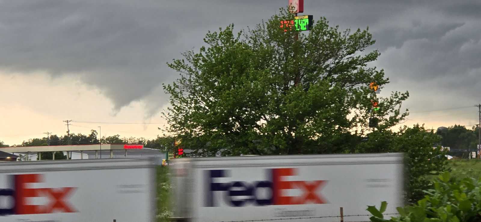
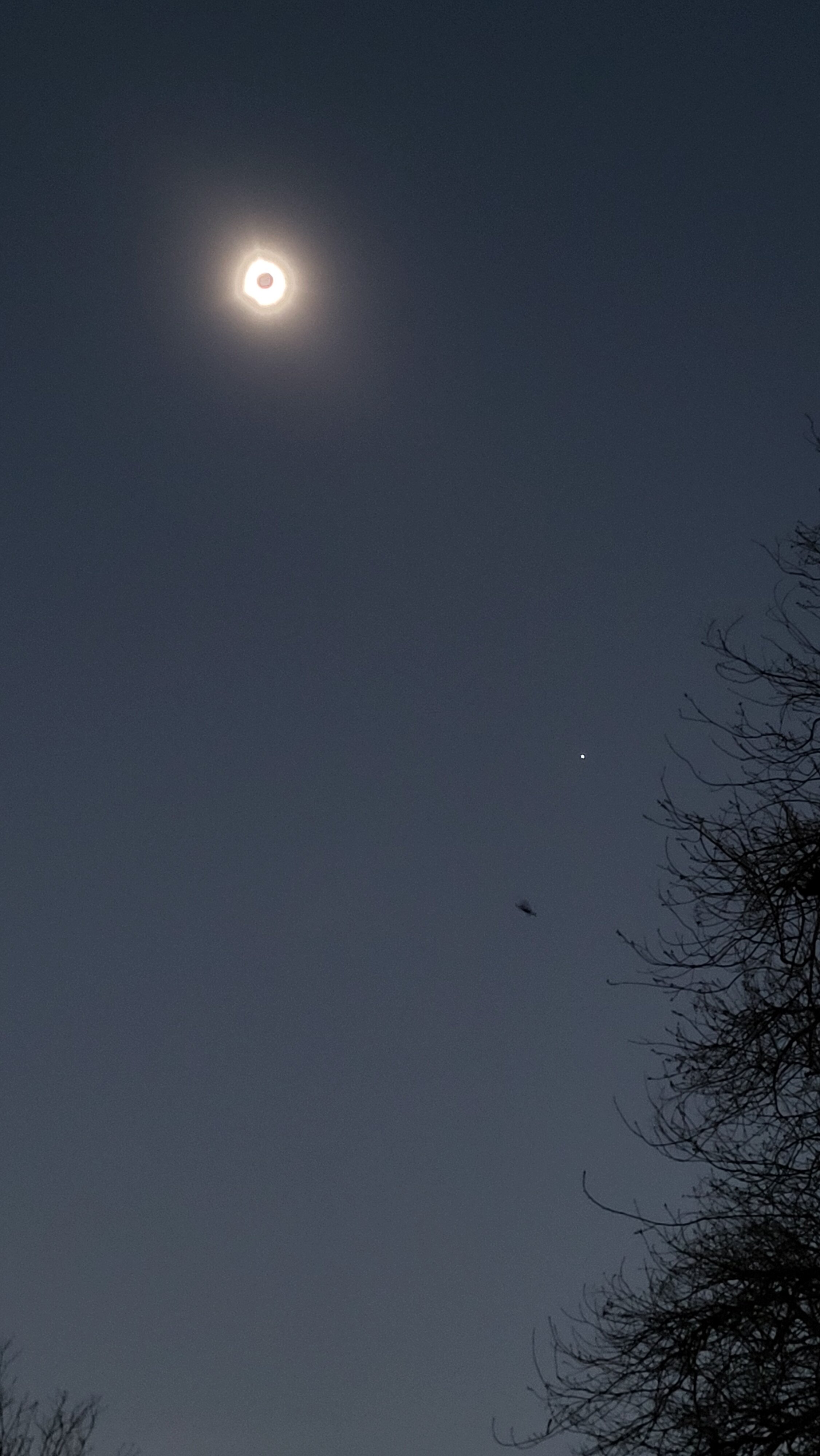
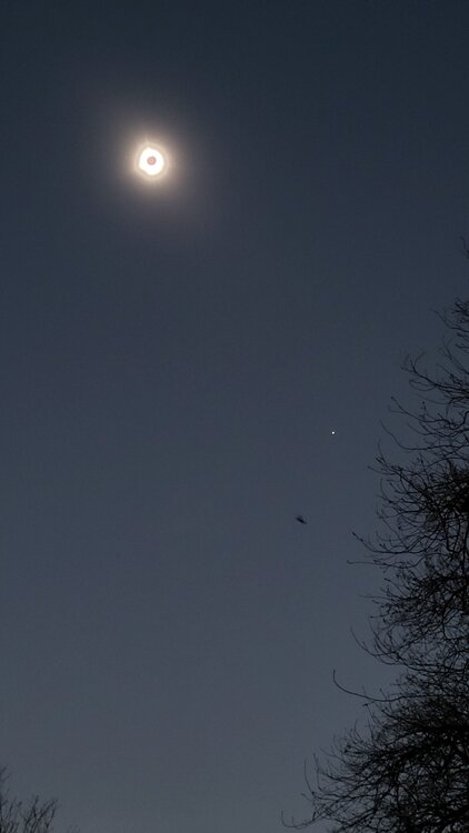
Wow most of us really lucked out on the decreasing clouds. I had to react thank-you to the satellite pics. We stationed in Arkansas, but most of my posts (and every detailed one) is here. So if you don't mind, I'll share my account here in G. Lakes / Ohio Valley. This is where I will come back to reflect on the eclipse, and our shared experience. I still do so in the Tennessee Valley 2017 thread. Sunday I went to Memphis to meet my usual storm chase partner there. Monday as we rolled through Jonesboro, AR it was evident our sky would remain clear. We stopped in Black Rock, AR. Set up in a little park across the street from a Mt. Vernon Baptist Church. It's on! Partial phase begins with little fanfare as always. Two guys are already there. A family joins. Local neighbors wave and greet us. Soon the crescents are under the trees. Deeper into partial the light gets weird. By 70% it's quite obvious. Contrast ramps up, deeper shadows. Colors change a little bit. By 95% it feels like we're on another world. No shadow bands at our location (we did 2017). Too early in the season for cicadas. However, a cat fight happens at about 98%; not sure if related, we just hear it somewhere. We get a classic eclipse breeze, beyond just cooling off. Wind flips 180 degrees to emanate from upstream totality. Oh yeah with 30 seconds to go the western sky gets deep navy blue or purple. It's not a sharp shadow, but it's obvious. It's something between a curtain and a paint job. I don't feel like it's eerie; it's majestic. We are about there! Totality arrives like someone turned off the lights. Remaining cirrus looks like noctilucent clouds (they're not). I catch the diamond ring going in. Careful rehearsal (unlike 2017) pays dividends. Right as the eclipse glasses go dark, naked eye the diamond ring. The moon is darker than I'd imagined. Intellectually I know it'll be black; but wow, it's black alright. Black button sits over the most gorgeous white light I've seen since 2017. 5-6 filaments stick out from the corona fairly evenly spaced around, two are more dominant. Smaller pink/orange prominence is visible at the bottom. Corona has that solar maximum power feel like it just wants to explode! In questionable judgement I naked eye two Bailey's Beads coming out. C2* (going into totality) is relatively safer because our eyes are sun adjusted. C3* (coming out) is risky because our pupils are wide open. Well two days later I can still see. C3 happens quicker than I'd anticipated despite my eclipse timer. Bailey's Beads are bitter-sweet; so beautiful, but totality is over. Umbral shadow fascinates me. Per rehearsed routine I just watched the umbra coming into totality. C2 goal was the diamond ring. One has to plan a little bit so we don't miss everything happening in such a short time. C3 is the time to photograph the departing umbral shadow, which can be done reasonably easily compared to the actual corona display. Ditto 360 deg. sunset/rise, which we do. * Official guidance is never to look at the sun directly. They say even the diamond ring and Bailey's Beads are not safe to look at with naked eye. On the way out we reflect on the powerful emotional experience. 2024 was a classic total solar eclipse. Corona was the power display in my opinion, near solar maximum. 2017 we were near a solar minimum. Corona was less wound up. 2017 was asymmetrical but more delicate with 3 longer streamers leaping across the sky relative to 2024 filaments. However 2024 was darker and filaments still incredible. I feel like 2024 was the classic dark total solar eclipse. @vpbob21 and @Floydbuster I figure the high clouds scattered some light your location in 2024. Your sky looks like our 2017 where the moon was farther and totality shorter, smaller shadow. Photos don't do it justice. While a picture is worth 1,000 words, our imagination is worth 1,000 pictures. Ask a professional photographer layering this thing. I have elected writing and just cell phone photos. We did not attempt technical photos. Elected minimal gadgets for maximum viewing. I double checked myself with two other eclipse accounts. Don't want to forget anything. Bob Berman. The Sun's Heartbeat. Totality; the Impossible Coincidence chapter Mabel Loomis Todd. Total Eclipses of the Sun. Description of a Total Eclipse chapter Umbra shadow, 360 sunset/rise, Totality

-
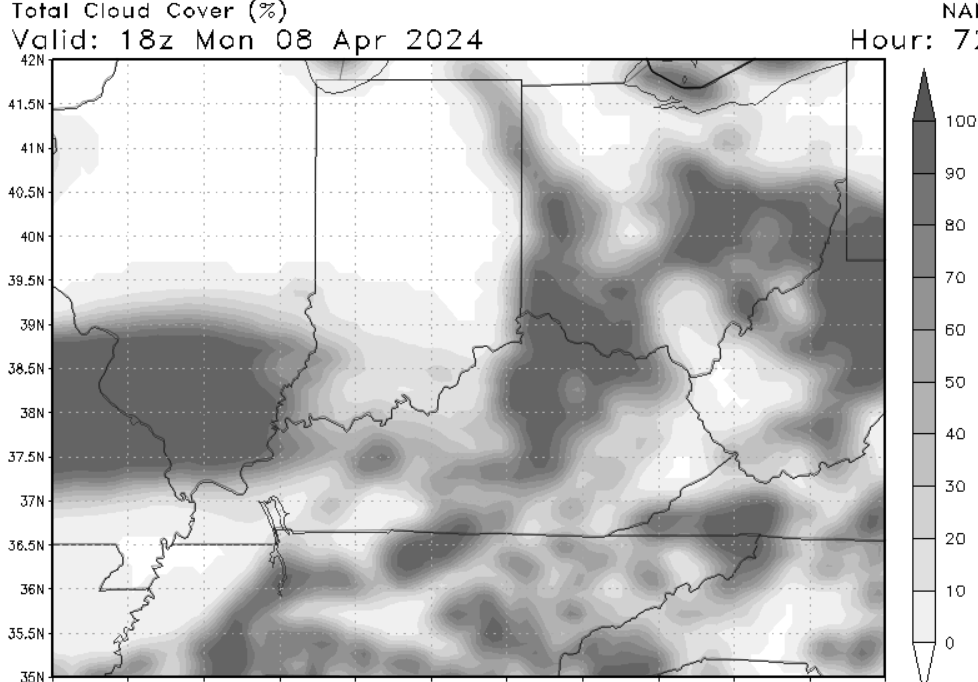
Had a thought this morning about making it work through thin cirrus. First, the chart below is solar flux. I feel like it offers a better picture than cloud forecast, which is straight coverage. Even high cloud model forecasts NAM hardly differentiates between thick and thin. Canadian does somewhat. This is from the NAM and it's similar to RRFS output. Still too many hours out for HRRR (which doesn't present high clouds well anyway) and the ARW/NSSL which will be valuable. ARW/NSSL is more precise than the NAM, but none promise accuracy. 18Z Edit this section (and other strikes italics): We'd thought about central Arkansas south of the high clouds, and hoping the increasing mid-level clouds from the south don't make it. Well that's a hell of an all-or-nothing gamble. Mid-level clouds thickening would block the show and be an utter disappointment. We are going to hedge our bets with the thin cirrus. I figure everyone reading has seen WPC and the Mid-South thread the needle chart. We concur. Chart below is different, again it's downward radiation flux. It's an hour after Totality because 19Z the high clouds didn't contrast well. New: Arkansas is looking better; we'll see how it goes, but keep met discussion to this region below.. Northeast Arkansas, Missouri Bootheel, Southern Illinois and Indiana are doable. I'm more optimistic than WPC about Western Ohio, but no promises. Note the lower values in central Indiana and western Ohio, by gentle gradient, are sun angle not cirrus. The smaller lighter areas are cirrus from Mizzou through southern Illinois to southern Indiana. Eastern Ohio of course has the departing morning wave too. Trying to dodge cirrus streaks is futile. We will lean south, but not much farther southwest than northeast Arkansas. Could be Bootheel or IL/IN. Thin cirrus would still show most of the eclipse. Think full moon at dusk, it shows through cirrus. The high clouds Monday midday will be darkened by the shadow, which helps greatly. Near a solar max the bold corona will be visible through thin cirrus. Longer delicate filaments are in question thru cirrus; however, they might be anyway near a solar max. 2017 gorgeous streamers were partly compliments of the solar minimum, though they can happen anytime. Finally the moon shadow would be a visible sharp line rapidly moving on the high clouds, like a flying saucer in a B-movie. I’d much rather the majestic navy-blue purple curtain shadow approach associated with clear skies, but the more marked shadow would actually be quite interesting. Obviously we don’t want to experiment with cirrus clouds. Hoping for clear skies. Last post before travel Sunday. By 00Z additional high-resolution products come out, and they are fairly self-explanatory. We eagerly await 18Z data and especially 00Z when the ARW and NSSL products will go through Monday afternoon. We will base from Western TN/KY Memphis. Totality destination will be firmed up Monday morning. Probably can't wait for 12Z as we need to get going early. Plan is to set up with hours to spare. In 2017 we arrived about an hour before partial phases started, but that was a layup 45 minutes from home. Looking for more cushion this time. Here in 2024 we will start south of Totality to save some bucks, and to hedge final destination in Totality.
-
Cirrus does form in a hurry, and it moves fast on jet stream level winds. It will be a forecast challenge. However it's not stopping us! Anything other than thick overcast will offer a show. We saw Totality in 2017 so the pressure is off, playing with house money. Obviously we want to see it again. One thing high clouds give that clear does not, is the sharp shadow in the sky like a B-movie alien arrival. 360 sunset colors are accented even more; think sunrise/set with high clouds. Sounds interesting but Hell No I'm not chasing that! Our goal is to sniff out some clear skies. Even broken cirrus moving along could give 1-2 minutes of full show in close to 4 minutes of totality. I think getting deep into the total path is important in case one loses time to passing clouds. Cirrus forecast looks like ribbons under an otherwise very thin (and broken) veil. Compare visible satellite earlier today with model output. Euro is definitely broad brushing high clouds and it shouldn't be that bad. Said jet stream and subtle lift could easily produce that much cirrus (a risk) but the NAM and Canadian try to get more granular - and the result is broken cirrus and/or ribbons of cirrus. This may be my last post. Saturday will be preparations, packing, and of course the higher resolutions models. Everyone can look at the hi-res stuff by then. Sunday is travel day. Example: Indiana and Ohio have workable real estate in this prog. Little patch in the Missouri Bootheel is obviously not reliable this far out, but it gives the idea of coverage. Illinois probably won't be as bad as shown. So this is not a forecast. It's just an idea of somewhat more granular presentation than the coarse Euro. High-res stuff will have even more detail.
-
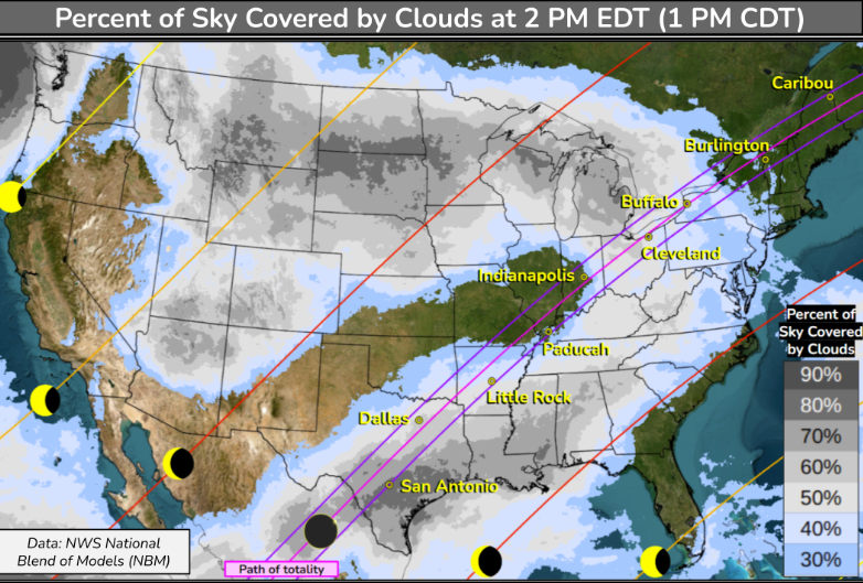
Weather Prediction Center WPC is posting charts now. Upstate NY to New England is in play. For the Heartland, Missouri and Illinois have best odds on today's models. Some EPS give northern Arkansas a little more love. Some CEPS give Indiana slightly better probability than the Multi Model Ensemble below.
-
Monday morning got out of the gate quickly, but the afternoon / evening underperformed forecasts in our region. NAM sniffed out the issue Monday afternoon and evening. LLJ didn't ever recover here. It did Ohio Valley, enough for them to overcome our cutting off moisture. Then the Deep South had some classic late evening. Severe is often a headache to forecast outside the Plains. Couple tor reports North Alabama. Of course the Tennessee Cumberland Plateau got its obligatory tor. I believe the elevation, while staying relatively flat, gets greater low level flow.
-
I recommend the short drive to Totality. It's not hard if 30 minutes or less. Remember 99% partial is like losing the National Championship by a point. Even if the forecast is a mess, a 30 minute drive is absolutely worth the try for a once in a lifetime awe inspiring phenomenon. Even at 99.9% no corona or prominences are visible. No 360 degree sunset. The shadow would be evident to your side, and you'd see shadow bands on a white surface for several minutes. Animals will react. However the difference between that and Totality is the difference between kissing and getting married (and you know). Take side roads, especially back. We did in 2017 from 45 minutes away. We were relaxing back in town over steak dinner, not caught in traffic. This applies local/close. Long distance travel will be a whip Monday afternoon/eve. We'll stay over another night there in 2024. Bottom line: If you can get to totality in 30 minutes, even with a crappy forecast, try it. Totality hype is one of the few things in our hobbies that's not over-hyped. In fact it's under-hyped. No words or photos capture the incredible everything(s) about Totality!
-
Some models show low, mid- and high cloud forecasts. Might depend on the website. Also when we get into range of high-resolution the cloud forecasts will be more precise (hopefully also accurate). Globals tend to smear out clouds. Below is downward solar flux. In contrast to clouds (all or nothing) the solar flux offers hints at cloud thickness and coverage. Still six days out so don't take it verbatim. Just sharing another tool to get another look at the situation. Red is good white is bad. Been a couple days due to severe wx at work. @RidingtimeI want to say prioritize the eclipse. Depends on how often you get back to see family. Note the Mid South is another option not too far from DFW - iff such a scenario holds. Ohio Valley has been less consistent. I'm looking fwd to hi-res models this weekend - both for precision and hopefully accuracy.
-
Tennessee could have beaten Purdue. All those 12-15 FT jumpers for 2 points were just awful shots with low expected value. And lots of time on the shot clock to boot. Yeah try a 3 if open. Otherwise go inside and get fouled. I'm pissed. Though a Kansas guy, I've gotten attached to Tennessee basketball. Still a great season for the Vols! Congratulations to Alabama first Final Four in school history! Fans just have fun and soak it in. UConn is a tough assignment. Players should not fear UConn. Fans manage expectations and enjoy it. That's easier said than done though. Wichita St. 2013.
-
I suppose April climo they gotta drop the 10% tor for Tuesday. NAM suite is quite linear and positive tilt. LLJ never restrengthens or backs late Tuesday. Now the Globals do so, and I figure CAMs like RRFS and HRRR do too; because, they go line of pearls. My gut says the NAM but it has a cool bias. That said the NAM can sniff out LLJ failures. So if you get anxious about severe, don't fret just yet. If you chase, it's conditional. I'll be tied down with work so no chase plans. Any personal forecasting is 100% eclipse right now. I hate the cloud cover forecast but some downward solar flux versions offer hope. As we saw in 2017 globals often start too cloudy due to resolution. Flux helps a bit, but of course the high-res stuff will be much more useful. We need another forecast rally in 2024!