nrgjeff
-
Posts
4,253 -
Joined
-
Last visited
Content Type
Profiles
Blogs
Forums
American Weather
Media Demo
Store
Gallery
Everything posted by nrgjeff
-
Humidity scale is expanded. Old: Humid, Ridiculous, Ludicrous. FUBAR is an additional category. 91/77 in KCHA. Welcome to the Persian Gulf, at least the Td part.
-
Carvers covers the different flavors of El Nino well, just above. John covers other hemispheric pattern drivers top of page. I prefer QBO trend to a steady value, trending down and ideally into negative. El Nino looks like it wants to stay basin wide. While I have concern about strength.. If the summer pattern can hold into fall and winter, it's of course favorable for temps Middle and East parts of our Region. Mid-South should get its turn too. We'll know more about this through Sept. and into early Oct. Note the polar source remains very warm. Canada and Alaska have MA temps this summer. In El Nino the Southeast relies on the southern stream anyway. If the current Atmo response continues into autumn, I'd be cautiously optimistic. If by wavelength or other debacle we torch, I'll just chalk it up to living in the South.
-
Mid-South portion of our Region had a summer. The rest of us enjoyed a mild summer. Indeed we may all get it next week. Looks like a pretty stout ridge building. Twitter is getting a little carried away though. Did they forget Normal temps are dropping now? Leaves look good right now. Even that heat won't be a problem before September. We need to avoid more of that crap though. I generally agree spring is more important than late summer. Exception is if that ridge parks for 3 weeks. Doubtful though. Ridges tend to be short-lived this summer before retreating to the Deep South, Texas and Southwest. Maybe we can get a hurricane under that ridge for something to track. Though I'm not rooting for that over such warm SSTs, late Aug. is when the season usually ramps up quickly.
- 295 replies
-
- 8
-

-

-
- severe weather
- frosts
- (and 5 more)
-
Sexy outflow boundary sits to my west, even with a kink. Too bad it's capped and directional shear is low. Only speed shear is there. For that 2% Upper Plateau.. gonna need that outflow boundary to lift north. Possible with a break in the action, but I'm an Under bet.
-
Feels like May lasted a day. Dewpoints today are atrocious! Also need to motivate myself to get out in the middle of the night for the Perseids which also requires a little drive out of the city. It'd be easier if the US was still in the World Cup, overnight games. Apathy may prevail because I'm tired.
-
Thank you @PowellVolz so the CC dropped. Was rotation evident on radar? If not, I could see them thinking CC was something else. If a CC drop is co-located with rotation, then it should be a tornado warning. Back to today, I think the best shot is on the afternoon Mid-South mesoscale discussion. Boundary has slipped south of Memphis which is good. For chasers that flat Delta terrain is just what the doctor ordered! Though the meteorology remains conditional.
-
Catching up, what a week. Yes @Dsty2001 I believe that's a wall cloud on the previous page. While it looks scuddy, a likely collar cloud leading into it is the giveaway. Indeed, the whole feature is probably a wall cloud. Does anyone have saved radar data from the Knoxville tornado? Especially the few minutes leading up to the event. We had a power outage in Chattanooga at the time, so my focus was elsewhere. Looking at TODAY, a boundary sits across Tennessee from northwest to southeast. Boundary should focus any MCS and line segments. Perhaps closer to Arkansas the boundary can enhance SRH. Down by Chatanooga I think it's just good to promote straight line winds. Storm mode should be more conductive where SPC has the 10%. Though I doubt much will be visible if it's HP. Some of the CAMs have beefy blobs, which could contain hail. We are truly having April in August. Storm mode does favor MCS (summer) but the jet stream and hail are out of season.
-

Fall/Winter Banter - Football, Basketball, Snowball?
nrgjeff replied to John1122's topic in Tennessee Valley
Speaking of the Vols.. New Zealand upset Norway in the FIFA Women's World Cup opener. Home field probably helped with the 1-0 win. Guess who scored the goal. Former Lady Vol Hannah Wilkinson! So in a sense, football season has started. -
Dialed down the heat forecast late week by 4-5 degrees. Looks like scattered t-storms most days vs clean ridge. Risk is that MCSs timed night and morning still allow hot afternoons. However overall, heat forecast has backed off locally. Other parts of the US it's still Pain. Still the Tennessee Valley and Oho Valley have benefitted from a hot bias in models. In other words, the forecast gets less hot as the extended becomes short-term. Very end of July into early August remains a possibility for hotter than normal. However the bias has been for those forecasts to diminish inside 10 days.
- 295 replies
-
- 3
-
-
- severe weather
- frosts
- (and 5 more)
-
Dewpoints are atrocious right now. Review of the Spaceballs scale... 65-68 humid. 70-72 ridiculous. 74-76 ludicrous. Most of us have gone plaid.
-
Yeah I think we are going to escape with a reasonable summer. It ain't over until the August lady sings, but evidence points to more of the same. Global wind has dropped*, but it's already progged to rise again (milder signal). Now it does look like a hotter than normal period late next week and early the following week, so straddling the weekend of July 22. Anomalies in our region won't be too high, but it's the hottest time of year by climo. We all knew late June would not be the only hot burst. *Note the next couple weeks could be a bigger national heat story, just thankfully not in the Tennessee Valley or Ohio Valley. Desert Southwest may set record highs. Texas goes back into the cooker. Soon it'll be football season. Training camps open in the next couple weeks! Finland getting ski season going in October? Makes sense at that latitude. Big NATO ski party, haha!
- 295 replies
-
- 5
-

-
-
- severe weather
- frosts
- (and 5 more)
-
You didn't miss much. Beach >> non-rotating storms.
-
Best chance of a rude SER is probably days 15-30. Positive global wind could go negative which would play nicely with a -PNA. Until then the Desert Southwest has their even ruder ridge with record highs forecast next week. That keeps us mild. Even weeks 3-4 all models (mid-range and weekly long range) have exhibited a sharp hot bias for us this summer. Continued benign with out a few really hot days is my feeling. Trend is our friend until it ends.
- 295 replies
-
- 5
-
-
- severe weather
- frosts
- (and 5 more)
-
ECMWF and especially CFS weeklies have punted even that one hot week in July. Seems too good to be true, but the mid-range models 11-15 day stayed the same or even backed off. They were never super hot here. Bias corrected that normal 11-15 day is BN temps Tennessee Valley and Ohio Valley. Deep South heat may creep into the Mid-South at times. Barring a sharp turn in the trend, easy ride may continue for East Tennessee. Weeklies are usually only good for two weeks. Steady patterns in peak winter or peak summer can be useful 3rd week; we are peak summer climo. So there's a chance these benign weekly forecasts are right. And we get off easy this summer.
- 295 replies
-
- 5
-
-
- severe weather
- frosts
- (and 5 more)
-
Latest models (if we care) have El Nino peaking early. Then it stays below Super for winter, esp on the EC. Spread includes anything from strong to weak, with plenty of members in the moderate to weak area going into winter. We need to see how things go for several more weeks.
-
We're gonna need these weekly charts to go ahead and be right. That would be great. (Office Space boss voice). CFS and EC both go deep into August, and none blow up a SER. Relatex to Jax's post above, they have the week of the 17th hot, but it's July 17th so.. If those forecasts are right (not usually past week 3) then that'd be it for summer. One advantage is persistence, mostly mild with just a few hot spurts. El Nino and a cranking global wind continue. Then trend is our friend until it ends. Hopefully we can hold onto the mild summer overall.
- 295 replies
-
- 6
-
-
-
- severe weather
- frosts
- (and 5 more)
-
We have the answers. @Jesse from KY Enhanced both Saturday and Sunday. SPC was likely waiting for boundary placement before forecasting corridors of more straight line wind. This is my first time on the board in a while. Work was a whip last week. I was kind of expecting a small 5% Tor Sunday since they did Saturday. Sunday has greater flow aloft, though Saturday did have the more obvious outflow boundary.
-
Regrettably I could not get on here over the weekend. Looks like the Memphis area got slammed on Sunday. Chattanooga had a good line of storms, but no major wind. Yes those MCSs are notoriously hard to predict. High-res CAMs were garbage until the night before. That's actually not bad for summer MCSs. Models just can't get a handle 36-48 hours out like synoptic winter/spring. 00Z so about 18 hours ahead, models got the East Tennessee MCS blowing on outflow out of Kentucky. Models did a little better with West Tennessee a full day and a half ahead because the focal point was a little closer to the synoptic system. In contrast East Tennessee was mesoscale driven by that outflow from previous convection. Fun forecasting.
-
The PDO could start to move with El Nino closer to fall. PDO is currently pretty stubborn to this point. QBO I believe the rate of change is most important. Falling going into winter would be a cooler signal. If the QBO bottoms too early, it could be slowly rising in winter. Super Nino looks super mild to me. I suppose northeast Tennessee and the Mountains could benefit from the storm track. Could be tough getting cold air in place from BNA to CHA and points southwest. Of course it only takes 1-2 systems well-timed with cold, but super Nino winters are usually warm vs weak/mdt Nino.
-
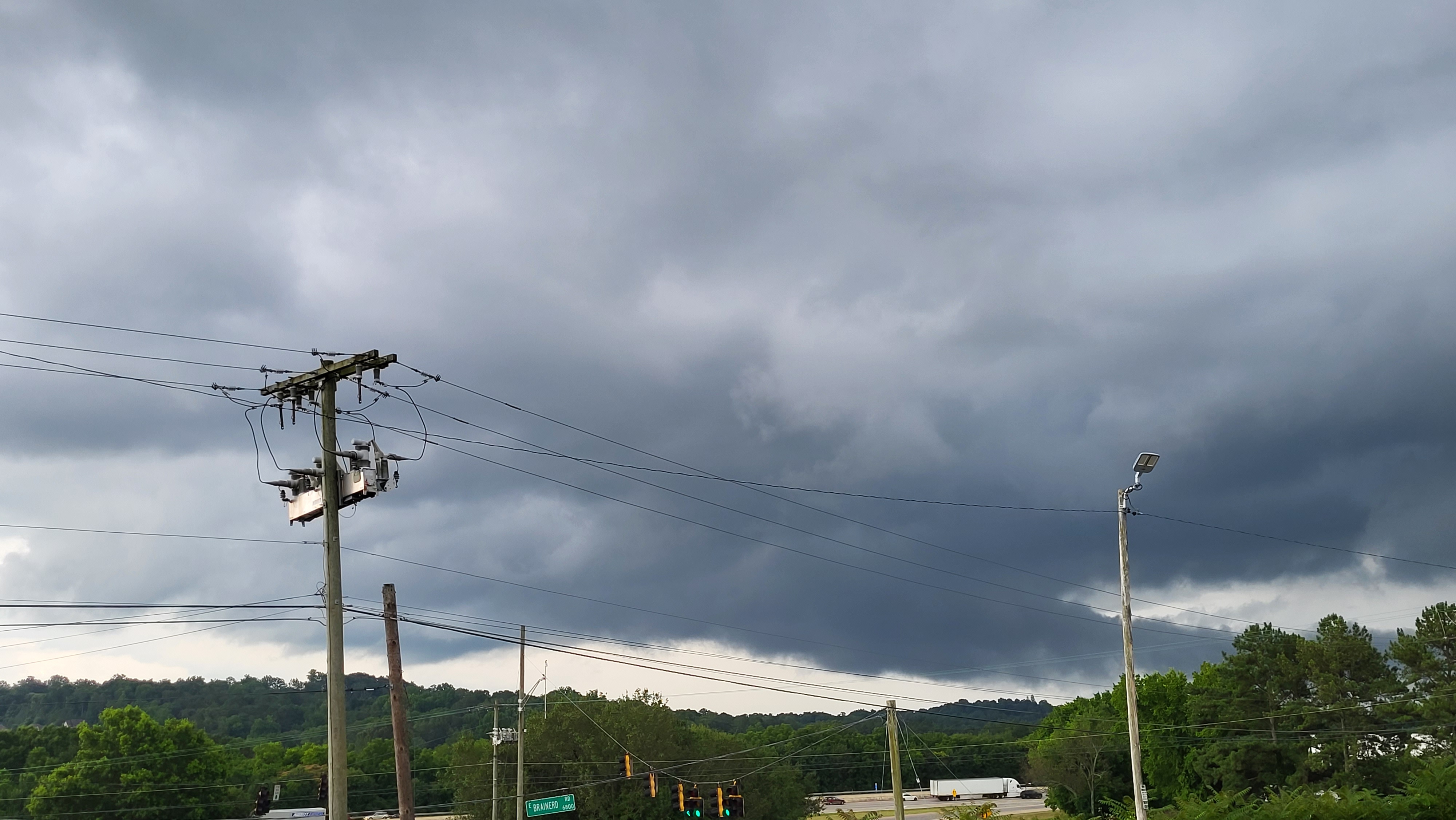
Monday the cells had slight rotation due lingering winds turning with height. Fortunately the turning was not enough, and the speed shear was weaker than on Sunday. I was doing time-lapse towering Cu just for fun near Chattanooga, and discerned some turn but only with the speed-up. It was weak, but still fun to time-lapse. This picture is actually on Tuesday. If you know the area, I was at the I-75 interchange with East Brainerd Rd. Bargain Hut parking lot offers a little perch for viewing, if one does not mind the power lines. The view is not nearly as far and wide as from US Express, but BH was on my way already. I was not chasing, but yeah I stopped for the tail-cloud like feature. No rotation was observed, at least not in real-time. Due to time constraints, I could not do a suitable time-lapse. Too cool for severe and the heavy shower didn't have lightning either.
-
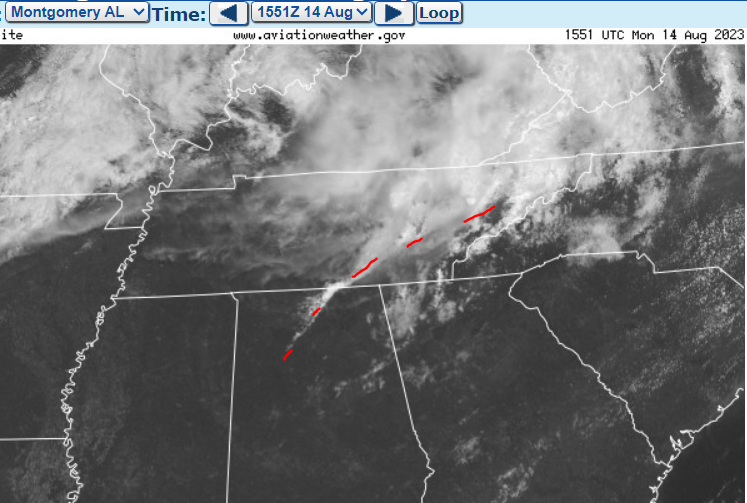
MD #1035 for central Alabama Storm Prediction Center Mesoscale Discussion 1035 (noaa.gov) kind of leaves the door open for a couple rotating storms. I would say the southern outflow boundary (green) has the most locally enhanced SRH. Northern OFB (yellow) has less direct access to the LLJ. Southern OFB also has better wind barb kinks. I used surface chart wind barbs and dewpoints along with visible satellite to place those outflow boundaries.
-
I think I follow Nadocast. It can get carried away, but it also gets things like Plateau magic. Can I say magic? Nobody got hurt. I did not know Ryan runs it though, haha! Just another tool either way. Thanks @John1122 for the reports Sunday. Glad you and yours are well. Nice pics @PowellVolz and @Holston_River_Rambler showing up the Mid-South with action in scenic East Tenn. I'm fairly confident the Cumberland Plateau over-achieves with tornadoes because it's elevated, which gets it greater low-level inflow. Wind typically increases with height. With the exception of a few areas of (scenic) bonus relief the Plateau is relatively flat compared to say the Mountains. I believe Alabama's Sand Mountain (more a plateau) gets the same effect. Areas of upslope likely play a role too. Any of the above increases local storm relative helicity SRH / low level shear LLS. Main reason chasers pick boundaries is due to greater SRH and LLS. Terrain does the same thing. High Plains chasers love terrain plays like the Palmer Divide and Raton Mesa, which also increase SRH/LLS. Palmer is also associated with the Denver Cyclone DCVZ. I'm not sure the Cumberland Plateau has anything like the DCVZ, but I believe the Plateau gets greater SRH/LLS. Combine boundary with terrain, and odds increase. If a boundary is over the Plateau, it may go!
-
Our two Hollies are slowly recovering, but it took until late May and early June. Our Japanese maple is fine. Some others dropped leaves, but had bounced back already in Feb. Chattanooga didn't get it as badly as up there though. Anyway the next week looks rainy around our region. Hopefully we can break the drought in parts of the region. Drought monitor shows dry and or moderate drought. If all goes well that's history after next week. Interesting pattern with strong 500 mb flow forecast next week. However, impulses (and LLJs) are timed night and morning, not really severe prime time. In summer one looks for MCSs not overnight severe. So, let the soaking rain begin.
- 295 replies
-
- 1
-
-
- severe weather
- frosts
- (and 5 more)
-
Yeah I'm really enjoying these dewpoints. Fetch from the ENE goes all the way to New England. I know it won't last. Next week will gradually return to reality. It'll be June! Guess the core of summer is humid either way, so hope for BN temps and AN rainfall. What I really want is some northwest flow thunderstorm action later in June. Only after that I will be ready for pop-up summer afternoon stuff. I'm not really counting on the NW flow part though. Week 3 is the wish-cast zone, lol!
- 295 replies
-
- 2
-
-
-
- severe weather
- frosts
- (and 5 more)
-
Yeah @Carvers Gap seems somebody in Riverton with my view of the world wrote that AFD, lol! Smoke has reached Tennessee, but nothing intense. Low dewpoints on the east wind is nice, but the high press up North is funneling in smoke. Sky is milky where it's blue. For a minute I was missing deep blue sky; however, the only path to that now is a pure tropical airmass. Eh, I'll take smoke (mild of course) over 70 Td.
- 295 replies
-
- 2
-
-
- severe weather
- frosts
- (and 5 more)