nrgjeff
-
Posts
4,258 -
Joined
-
Last visited
Content Type
Profiles
Blogs
Forums
American Weather
Media Demo
Store
Gallery
Everything posted by nrgjeff
-

Fall/Winter Banter - Football, Basketball, Snowball?
nrgjeff replied to John1122's topic in Tennessee Valley
USA loss to the Netherlands. Guess that's what thunder means. -
December 2022 Medium/Long Range Pattern Discussion Thread
nrgjeff replied to Carvers Gap's topic in Tennessee Valley
Relaod. Rutgers (not shown) has AN snow on the southern periphery of Asia snowcover. We patiently (or not so patiently) await the North America response. Even if SER (or more likely south-central ridge) early, the cold should eventually win out.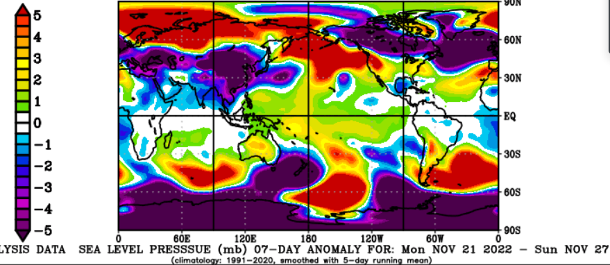
- 582 replies
-
- 4
-

-
- snow
- freezing rain
- (and 4 more)
-
December 2022 Medium/Long Range Pattern Discussion Thread
nrgjeff replied to Carvers Gap's topic in Tennessee Valley
I figure that SER, really more of a south-central US ridge, will try to hold on through early next week. Eventually the dam breaks in December*. Just too much blocking. *That's a generalization. Not a forecast. I have a long infamous history of jinxing weather patterns; so, just idle chatter.- 582 replies
-
- 7
-
-

-
- snow
- freezing rain
- (and 4 more)
-
Fall 2022 Medium/Long Range Forecast Discussion
nrgjeff replied to Carvers Gap's topic in Tennessee Valley
I don't normally just drop Twitter threads, but this one is legit. Original thread is accessible from my retweet. -
Mid-South Tuesday will depend on daytime heating. Overcast would delay thunderstorms until overnight, and Tennessee would probably escape severe. Mississippi would still face some risk Tuesday night. Greater sunshine on Tuesday would promote high temps over 65 maybe 70, and daytime severe thunderstorms. Scenario would also accompany a farther north and east warm sector for Tennessee and Alabama. Finally, the wind profiles are quite robust both speed and direction. Key to this almost winter set-up is Sunday. The weekend system won't send a front to the Gulf Coast. Sets the table for a quick and perhaps deep moisture recovery by Tuesday afternoon.

-
Fall/Winter Banter - Football, Basketball, Snowball?
nrgjeff replied to John1122's topic in Tennessee Valley
Turnovers were atrocious for both teams. Kansas needs to solve its size problem. After Duke I said it's how you work it. After Tennessee I see Kansas has a problem. Tennessee sharpened up second half. After my mental wounds heal I can get back to cheering for the Vols when they are not playing Kansas. Tennessee has a shot at winning the SEC, though it's not easy. SEC West has good teams too. Football today has offered closer more exciting games than pre-game spreads, which is nice. Later I probably don't want to watch the Sunflower State Showdown. Tennessee at Vanderbilt sounds better. -
Fall/Winter Banter - Football, Basketball, Snowball?
nrgjeff replied to John1122's topic in Tennessee Valley
Happy Thanksgiving! It has been a nice day chillin' with family in Chattanooga and watching more basketball than football. Multiple college games went into OT. Yes Kansas and Tennessee have a date Friday for the Battle for Atlantis Championship. I think we've met in that tournament before. Plus we scheduled home-and-home a couple recent years. So, Kansas and Tennessee is a wonderful holiday tradition! I'm going to try and just enjoy the game. I've come to really like Tennessee sports, but there's no place like home. My prediction, Final score within 2 either way. Cheers! -
Fall/Winter Banter - Football, Basketball, Snowball?
nrgjeff replied to John1122's topic in Tennessee Valley
GFS caught onto the two systems well before the ECMWF. Result is the Thanksgiving wave followed by that closed low later in the weekend. EC had everything coming out Thanksgiving before catching on. LOL! -
Yes in Dec. 1989 we kept 2-3 inches of snow for 2-3 weeks. It stayed pretty white, vs getting dirty, because it was so cold with little daytime melting. I can't imagine that in our current regime.
-
Oh wow Nov-Dec 1989 was ludicrous cold in the Plains. I figure the same here? December 1989 KCMO set its all-time record low two nights in a row at -22 but that's at MCI which was built in 1973. MKC got close to its all-time and it's been around much longer. MKC is in the Downtown heat island, so many went with the all-time story out of MCI.
-
2022-2023 Fall/Winter Mountains Thread
nrgjeff replied to BlueRidgeFolklore's topic in Southeastern States
European is markedly better than the GFS for a clipper right after Thanksgiving. Euro punts the midweek rain. So, the Euro shows great snowmaking followed by some natural snow showers in the Mountains. Black Friday opt outside. If the forecast holds, the choice is clear. In contrast to tracking zig-zags; usually, a big flip in the continental pattern like that holds. -
Fall 2022 Medium/Long Range Forecast Discussion
nrgjeff replied to Carvers Gap's topic in Tennessee Valley
A few days ago that was severe coming up from the Gulf. Now it's a clipper. Trends like that are bullish cold, but I remain pessimistic. Anytime I'm optimistic it's a jinx. Getting serious, two streams were always progged for Thanksgiving. Appears the northern one is now dominant vs previous southern. The obligatory Midwest winter storm for Thanksgiving is now forecast. If that holds, I'll be in the Southeast Mountains thread. -
Fall/Winter Banter - Football, Basketball, Snowball?
nrgjeff replied to John1122's topic in Tennessee Valley
Thankfully I missed all the news from Poland to Florida last night. Also did Taylor Swift have some sort of big ticket sale? It was the Champions Classic! Dickie V was back. All basketball baby! Michigan State "upset" Kentucky. MSU was already tested at Gonzaga while everyone else played small schools. No surprise MSU covered the spread, but I was surprised they won outright. Kansas upset Duke with stifling defense and coordinated (assists) efficient offense. It was a thing of beauty. Need to see the Vols do similar things. They have the talent. Colorado zone D just frustrated them, which is common early season. By January I bet Tennessee will shred any zone D. Did I mention I can't stand zone D? Unless my team is using it, lol! -
Fall 2022 Medium/Long Range Forecast Discussion
nrgjeff replied to Carvers Gap's topic in Tennessee Valley
Convection is trying to get into better (for cold) West Pac phases. However when the only Invest is in the Indian ocean, I say the muddled tie goes to the warm signal Indo Subcontinent. Keep in mind my job here is Devil's Advocate; so, I could be wrong. Except I'll be right in southeast Tenn. -
2022-2023 Fall/Winter Mountains Thread
nrgjeff replied to BlueRidgeFolklore's topic in Southeastern States
You love to see it. I'm feeling like some early Thanksgiving week -
Fall 2022 Medium/Long Range Forecast Discussion
nrgjeff replied to Carvers Gap's topic in Tennessee Valley
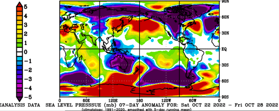
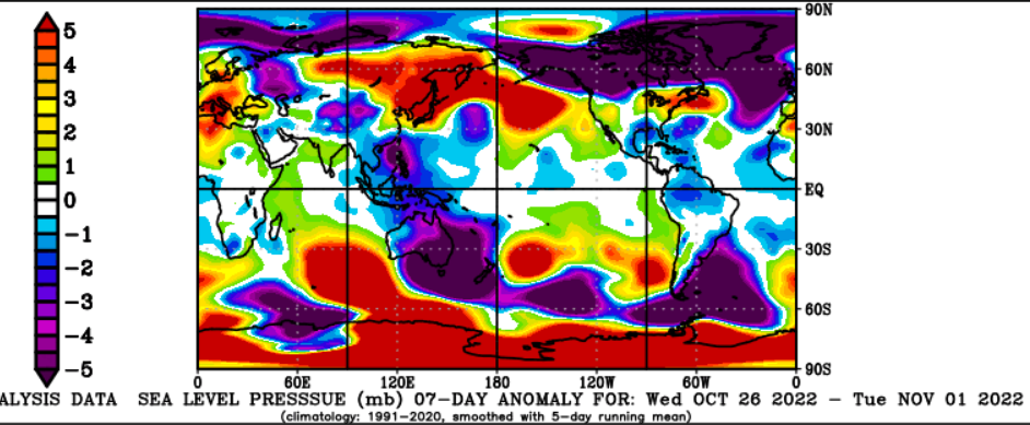
My favorite chart explains a lot today. Not shown, Rutgers snow cover is AN in the NH. Below we see high pressure all over Canada; hence, it's cold in the Lower 48. Note that Siberia is already back in low pressure. That's not just Putin's approval rating. I believe we get a mild couple weeks starting around Thanksgiving. The big question is whether this record -EPO in November (currently) foreshadows more blocking much of this winter. I'd really like to see a full cycle through both patterns. I thought we'd know more by Champions Classic Tuesday tomorrow. It'll have to be the Thanksgiving week basketball tournaments.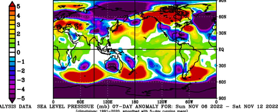
-
Fall/Winter Banter - Football, Basketball, Snowball?
nrgjeff replied to John1122's topic in Tennessee Valley
I wasn't able to watch much of the game. From what you post, and looking at the gamecast graph on ESPN I can deduce Colorado played zone D. Is that right? Vols need to penetrate that. Drive inside. High-Low is OK but don't just chuck 3s without probing. Otherwise, every team will play zone. I can't stand zone D. It should be punished with drives inside, drawing fouls, and even taking offensive fouls to establish physicality. -
If the mountains were not there, winters would be much better in East Tenn. However the Carolina cliff diving would be even worse, lol!
-
I'll take an order of Holiday severe weather.
-
Fall/Winter Banter - Football, Basketball, Snowball?
nrgjeff replied to John1122's topic in Tennessee Valley
Tennessee Football had a nice win over evil Mizzou. Today Tennessee men's basketball hosts Colorado. College basketball begins for real, vs a major. Then Tuesday is the Champions Classic! Life is better than I indicated in the main weather thread, haha. -
Fall 2022 Medium/Long Range Forecast Discussion
nrgjeff replied to Carvers Gap's topic in Tennessee Valley
The rain is needed. For southeast Tennessee the precipitation type question is answered by an old rock ballad. Cold November Rain by G&R. This overcast has me feeling very pessimistic about everything. No snow this winter, haha. -
Fall 2022 Medium/Long Range Forecast Discussion
nrgjeff replied to Carvers Gap's topic in Tennessee Valley
This helps explain the incoming cold pattern. High press eastern Siberia plays nicely with the AK 500 mb ridge forecast on models. Snow cover is also AN (Rutgers map not shown). Note snowcover is worthless without pressure context. Low press / high snow is stormy and mild. High press high snow sets the table for cold if it's delivered. Looking ahead, models don't keep the cold pattern long. However it bears watching. If the cold hangs in longer than a couple weeks, it could be the November preview of winter deal. Of course a quick strong mild recovery may also be a winter preview. We'll know more after the Champions Classic Novie 15th, because college basketball has all the answers, haha!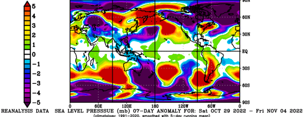
-
If the upcoming AK ridge driven cold pattern is brief; then, we can get back to a more La Nina warm pattern. It would tee up chances for late autumn and early winter severe.
-
Fall 2022 Medium/Long Range Forecast Discussion
nrgjeff replied to Carvers Gap's topic in Tennessee Valley
Please do not share the first image because it is a subscription. Does it look so familiar around here? Cold is coming, but could be very modulated into the shallow SER. Too early in the season to undercut. My favorite pressure chart is mixed signals; so of course, I'm bearish East Tenn. Maybe the Mid-South? I'm not sure if winter or severe, lol!
-
Fall 2022 Medium/Long Range Forecast Discussion
nrgjeff replied to Carvers Gap's topic in Tennessee Valley
UK Met Office just went cooler than normal UK through Jan. However they do not forecast for mainland Europe and certainly not North America. Still, their NAO forecast plays a big role, so... For EU energy security I hope Europe is mild, but we can't control any of that. US is fine either way. Yes I believe SER will be the dominant weather pattern in La Nina. However a colder secondary pattern is likely, maybe stout once or twice, esp Mid South. Nina is variable and the NAO may get negative at times. Check of my favorite 7-day mean surface pressure anomaly echos my mixed sentiment. For the most part cold and stormy is locked up Arctic. No big Arctic highs. However some is spilling into China and North America. Press chart with temperature colors.. Bonus. Australia is colder than normal with that South Pole block from hell.