nrgjeff
-
Posts
4,253 -
Joined
-
Last visited
Content Type
Profiles
Blogs
Forums
American Weather
Media Demo
Store
Gallery
Everything posted by nrgjeff
-
Yeah look for WAA at 700 mb and 850 mb. GFS and Canadian have it. Ukie too. NAM does not at 00Z Sunday and neither did the Euro. We eagerly await the 12Z Euro! Getting to root causes of forecast differences is indeed the OV PVA. We need Southern to dominate. Carvers explains very well the pitfalls. Event has a high ceiling AND high bust potential, more than usual even here. Maybe if I jawbone in the severe thread it'll help, haha!
-
Some snow north of I-40 mainly east of Nashville would not surprise me this weekend. Above progged moisture for TRI would get the job done. Upper Plateau has a good chance of sticking snow IMHO. Mountains will see some good accumulation at higher elevations.
-

Fall/Winter Banter - Football, Basketball, Snowball?
nrgjeff replied to John1122's topic in Tennessee Valley
For all you who think SEC refs are biased, Big 12 gave a clinic on poor officiating last night. Kansas was gang raped at the post and hardly any of it was called. Could have scored 4-6 extra points off free-throws. Texas got plenty of ticky tacky calls against KU. Normally officiating isn't an excuse, but this game was scripted to keep the Big 12 close for TV revenue. -
Threading the needle is the only hope for Southeast Tenn. Otherwise Carvers is right it's mostly strike-outs for the rest of the Region. What am I doing in this thread? Upper Plateau and Mountains could cash in if we can get a buffet line of clippers going. Last time I personally got snow from a clipper was probably KC circa 1990, lol! Does not count NC WV ski trips.
-
Perhaps the thunder followed by snow can verify in the mountains. Just saw another Southeast Tennessee system turn offshore snoozer. I've closed the books on winter Southeast Tenn. GFS picks up on the severe system Day 10 but there are typical questions 10 days out. Watch it slide south and snow on Chatty just to make me eat my words, haha!
-
Both! What else would one expect in the South? LOL Dear ECMWF tee up some North Alabama Day 10.5
-
I feel like this thread is missing posts. At any rate it's always a good time to jawbone severe weather early and often.
-
Fall/Winter Banter - Football, Basketball, Snowball?
nrgjeff replied to John1122's topic in Tennessee Valley
It's amazing what can happen when High Press is properly anchored north of the region. Too bad it's more than 10 days out. Tennessee showing up on the road. I know the game just started, but the tone is set! -
Yeah radar misses Plateau upslope. Most of the cloud, at least the nucleation, is below the beam from any radar site. I have settled into talking about everyone else's snow. GFS is caving to the warmer Euro. See you in the severe thread.
- 99 replies
-
- 4
-

-

-
- ice
- freezing rain
- (and 1 more)
-
Fall/Winter Banter - Football, Basketball, Snowball?
nrgjeff replied to John1122's topic in Tennessee Valley
Don't ask that question in the South, lol! My Cousin Vinny is classic South too. Tennessee, Auburn and LSU should have wins but all are on the road. UK at Bama may be more interesting than whatever spread comes out. Ole Miss at Florida and MSU at Arkansas might have tighter spreads, but who knows? Over in the Big 12, tell me which Kansas shows up and I'll tell you if they beat Baylor. It is a home game, but so was Kentucky. Bedlam (OU at OSU) will be a barn burner but I favor home team. -
With all the rain softening soil, even a marginal mountain wave event will damage trees. I concur with Matt.
-
Dyersburg is SLEET per correlation coefficient on radar. 11:37 am Central Time. Still true at Noon. Memphis airport is just above freezing but points north in the metro are 32 or lower and have 1/4 to 3/8 inch of ice.
- 99 replies
-
- 2
-
-
- ice
- freezing rain
- (and 1 more)
-
Little birdie told me Nashville knows they have a higher ice accumulation risk. They are trying to manage flash flood messaging first. I get don't confuse the public. However if there's a chance of meeting ice storm warning criteria, a WS Watch needs to be out. Advisory upgrade last-minute will make grocery stores comical tomorrow. And Memphis to Paducah. Nothing but pain. Cue up Mr. T / Clubber Lang gif. He just says one word to Rocky. Pain!
- 99 replies
-
- 7
-
-
-
- ice
- freezing rain
- (and 1 more)
-
Yeah we got the -ABNA trying to go. That's cold South China and Southeast USA if it verifies. 11-15 day did trend colder.
-
Surprised how quiet the thread has become. We don't do ice? I certainly agree ice is by far the worst kind of weather. Arctic front may surge more into Middle Tenn. OHX has been hinting at teeing up stronger winter / ice messaging after getting the public aware of the flooding first. Saw MEM occasionally above 32 on CAMs. Overmixing. Little CAD east of the Ozarks is going to keep the Delta freezing and probably also the Memphis metro. Pain. Pain. Pain.
- 99 replies
-
- 4
-
-
-
- ice
- freezing rain
- (and 1 more)
-
We need to do these boundaries in spring. When's the next chance of severe weather? Thursday sweet (adopted) home Alabama! Oh I forgot in spring the boundary hangs up south and we remain stable. In winter it surges north and we remain rain. This is the Way.
-
Fall/Winter Banter - Football, Basketball, Snowball?
nrgjeff replied to John1122's topic in Tennessee Valley
Missouri is going to get absolutely drilled with ice storm and snow storm. They don't call it the Show-Me State for nothing! Tennessee will almost certainly win tonight but I don't know about the spread. Auburn should win but Bama likes to rise to the occasion. LSU spread is ludicrous, but they will win. Kansas will lose. If Iowa state goes to say +6.5 I bet against Kansas. Texas Tech looks like the best Big 12 bet tonight. Kentucky and Duke are Final Four bound - excellent on the road. -
Classic Valley warm nose, lol! Ice storm Piedmont. You know, I'll take rain over ice any time. Maybe Chattanooga isn't so bad.
-
All the silly NWP precip algorithms aside, it's a fairly simple forecast. One inch of liquid qpf falling in below freezing air. Soundings favor freezing rain over sleet - not even close with that deep mild warm nose. I figure ice accumulations on trees and power lines averages 1/3 inch. That's much lower than those algos, but major ice storm criteria (>quarter). Half inch amounts will be common. That's a damaging ice storm. Any convective bands gets three-quarters which is truly crippling, but would be isolated to a county or two. Long duration all freezing rain events, lots of overrunning before last wave, are classic major ice storms. When was that awful Volunteer Electric ice storm, 2015? Several years ago I believe. Bottom line: First major ice storm in several years, this time West. We dodged a few bullets with scattered impacts a few years ago. I'm afraid this one is going to verify major. Pattern recognition is classic. NWP is far more consistent than the dodges a few years ago. This may be my last post of the event.
- 99 replies
-
- 4
-
-
-
- ice
- freezing rain
- (and 1 more)
-
ECMWF has much less frozen QPF out there vs GFS forever overrunning. Hopefully the Euro wins this one - impactful but not GFS major. At any rate this'll probably be my only post this week as work gets exceptionally busy. ECMWF weeklies are out and trend with CFS/GEFS weeklies. Cold through the middle of Feb. Too bad we can't buy a proper storm track or temperature profile. Perfect compliment to my sports weekend!
-
Fall/Winter Banter - Football, Basketball, Snowball?
nrgjeff replied to John1122's topic in Tennessee Valley
Cold and dry down here. I see few chances of snow southeast Tenn. Hopefully most days are sunny. Since weather is boring AS I'll be up late not waiting for models... but waiting for spreads and MLs on games like Tennessee at Texas and Kentucky at Kansas. -
I have little to add for tomorrow because I'm clearly not involved. For the Feb. 5-ish storm the GFS and ECMWF are about as close together as Russia and Ukraine negotiators. Hey, at least we're all still talking! Day 8+ Looking ahead seems to be some agreement in a warm Northern Plains cool Southeast US signal deeper into Feb. First 7-10 days of the month that's still cold enough here, before source region concerns build.
-
Fall/Winter Banter - Football, Basketball, Snowball?
nrgjeff replied to John1122's topic in Tennessee Valley
The real question of the day.. Tennessee will almost certainly beat Florida tonight. Will the Vols cover the spread? UPDATE: The question of Feb. GFS gets Chattanooga good snow almost on the exact two year anniversary. -
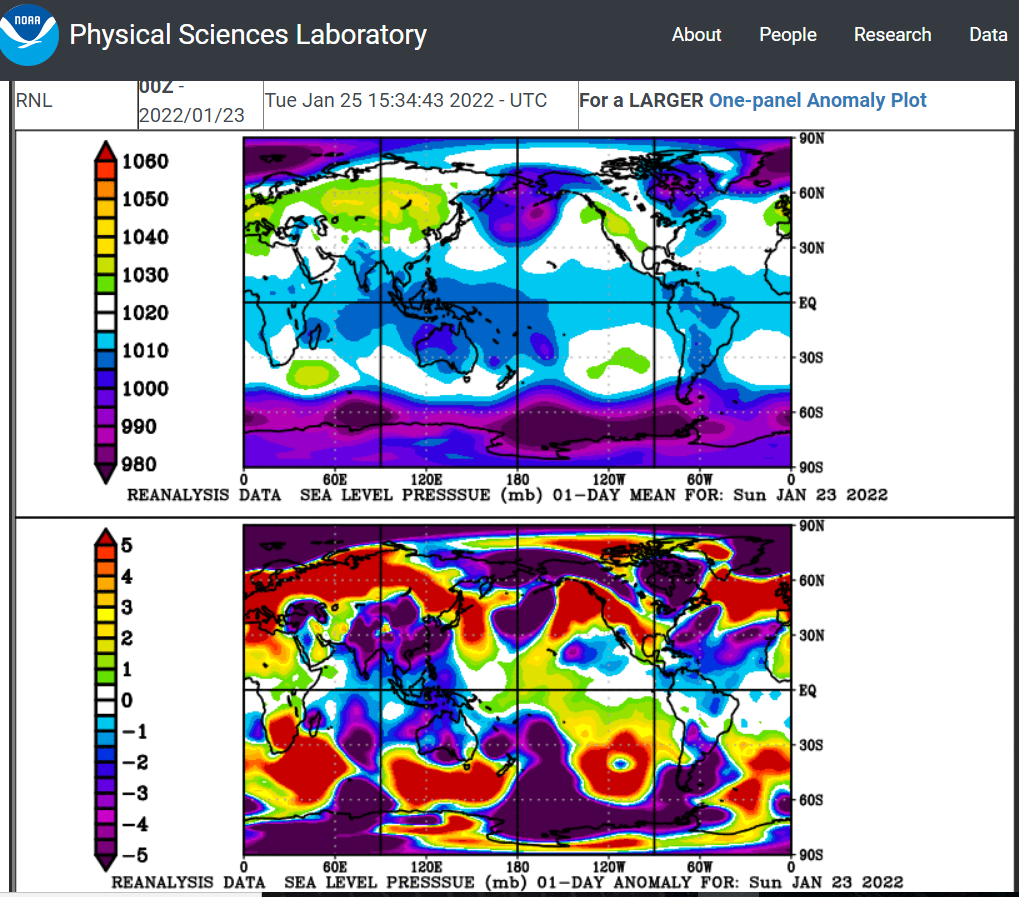
East Asia pressure charts are bullish for the Southeast US. ADDITION: @Carvers Gap longer post this page is rock solid. February is more susceptible to the NW jogs (esp La Nina) with SER attempts. Sharp blocking would keep such SER attempts modest. Honestly don't want any SER for southeast Tenn. Just the seasonal jet stream less South (Jan pattern in Feb) would help. From https://psl.noaa.gov/map/clim/glbcir.quick.shtml

-
Maybe we can get some severe weather ahead of that front.