nrgjeff
-
Posts
4,258 -
Joined
-
Last visited
Content Type
Profiles
Blogs
Forums
American Weather
Media Demo
Store
Gallery
Everything posted by nrgjeff
-
Now the 12Z Euro Op. has an I-40 snow slider around December 3. Of course nothing in my neck of the woods. So we get a couple very cold weeks in December. Then torch bal-winter. Like 2005-2006 warm fall, cold December, January thaw starts around Christmas. For a less pessimistic experience from me, we could get a winter mid-range forecast thread going. Unless this is it? Then I'll try not to post torch thoughts past Day 15. Yeah I'm still not over the January snow. Six inches within 15 miles. Blanked IMBY.
-

Summer-Fall 2024 Weather Disco Med/Long Range
nrgjeff replied to John1122's topic in Tennessee Valley
AI versions tend to favor the colder GFS over the ECMWF. If the EC ends up winning, we can look forward to a forced line of severe thunderstorms - with zero separation of cells. Meh.- 688 replies
-
- 4
-

-

-
- heat
- thunderstorms
- (and 7 more)
-
Summer-Fall 2024 Weather Disco Med/Long Range
nrgjeff replied to John1122's topic in Tennessee Valley
Yeah the mornings are ludicrous. GFS is a little cooler than the EPS. Either way we should get the nights and mornings under control even if temps remain AN.- 688 replies
-
- 3
-
-
- heat
- thunderstorms
- (and 7 more)
-
Summer-Fall 2024 Weather Disco Med/Long Range
nrgjeff replied to John1122's topic in Tennessee Valley
I see nothing to be optimistic about in the mid-range or long-range. Getting dry again. Warm all winter.- 688 replies
-
- 2
-
-

-
- heat
- thunderstorms
- (and 7 more)
-
Yeah the primary pattern is super warm. Secondary pattern will be very subdued this year, fewer weeks and weaker anomamies. I expect 3-4 cool weeks overall, perhaps over just a couple periods. Otherwise the SER wants to lock in hard. Mid-South might get one or two winter wx events. North of I-40 and along I-81 could get things on northwest flow. I truly expect to be blanked in southeast Tenn.
-
Summer-Fall 2024 Weather Disco Med/Long Range
nrgjeff replied to John1122's topic in Tennessee Valley
Caught some flooding and desert mudslides in Israel on X. I follow one account that is 100% weather. How they managed to not comment on the war is amazing. I guess, never stop chasing? Great weather stuff straight from Israel!- 688 replies
-
- 4
-
-
- heat
- thunderstorms
- (and 7 more)
-
Summer-Fall 2024 Weather Disco Med/Long Range
nrgjeff replied to John1122's topic in Tennessee Valley
La Nina and boiling everywhere else. I have forever SER with only 1-2 weeks of cooler weather twice this winter. Wake me up for severe. SST chart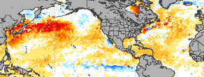
- 688 replies
-
- 4
-
-
- heat
- thunderstorms
- (and 7 more)
-
Summer-Fall 2024 Weather Disco Med/Long Range
nrgjeff replied to John1122's topic in Tennessee Valley
Re Shawn's post. These mountains are interesting every time. We really didn't have the mountain wave set-up, no inversion. Perhaps that means the mountains blocked like a good offensive line until the wind shifted. I had some 30 mph gusts of wind with the 8:30 Eastern band that went through Chatty; trees blew, carwash on the windows. Only lasted a few minutes - regrettable since I was busy. Wind has returned now but no rain, just mostly cloudy. We get that all the time in winter. Still the novelty of Helene being a TS in Tennessee is something else. It happens but it's rare. All that said our thoughts are with people facing much worse situations from the Mountains to the Coast, wind to flooding. I figure the Helene name will be retired. -
Summer-Fall 2024 Weather Disco Med/Long Range
nrgjeff replied to John1122's topic in Tennessee Valley
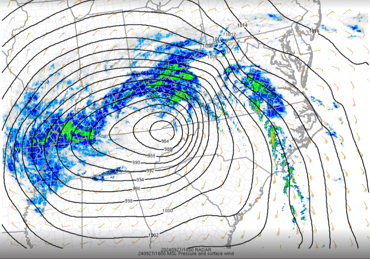
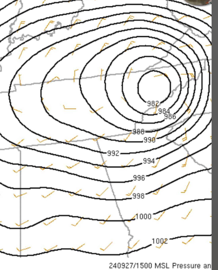
From Nashville: Latest SPC mesoanalysis shows the center of Helene is north of Knoxville, with very low pressure readings across Middle Tennessee including 989mb at Nashville and 987.8mb at Livingston. Although not records and just outside the top 10, these are still unusually low pressure readings for our area. Here's a list of the Top 10 lowest pressure readings at Nashville: https://www.weather.gov/ohx/pressure_BNA Top 10 Lowest & Highest Pressure Readings at Nashville (weather.gov)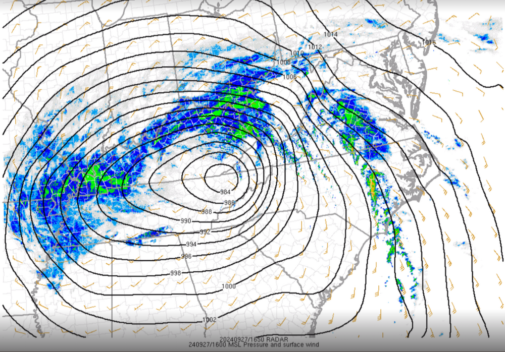
- 688 replies
-
- 3
-
-
- heat
- thunderstorms
- (and 7 more)
-
Summer-Fall 2024 Weather Disco Med/Long Range
nrgjeff replied to John1122's topic in Tennessee Valley
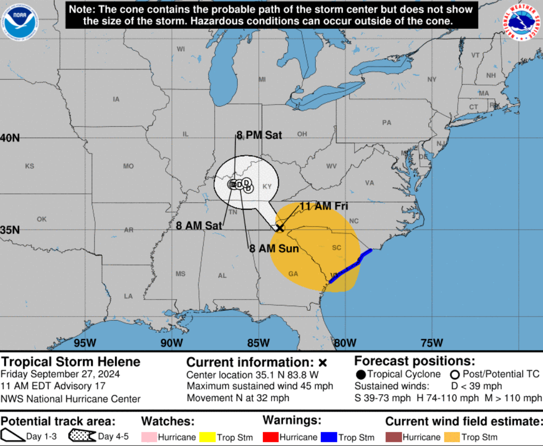
The link does not work. Here is copy and paste. TS hasn't been that close to me in several years. I also added a capture from SPC surface analysis.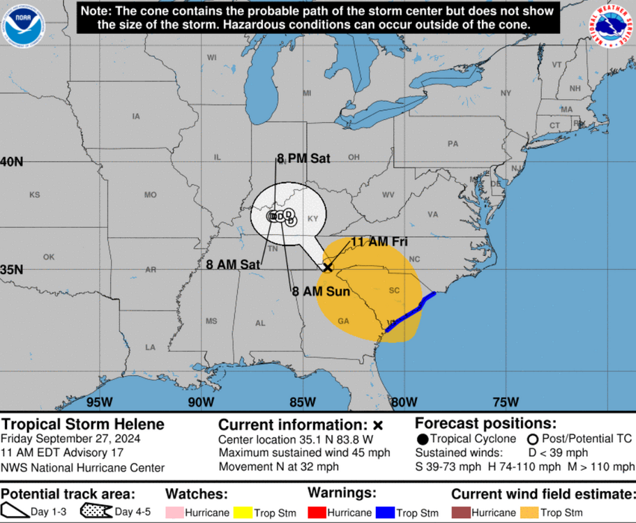
- 688 replies
-
- 3
-
-
- heat
- thunderstorms
- (and 7 more)
-
I think we had 20-25 mph about 30 minutes ago with a heavier cell. It has moved on and the wind died down in Chatty. Kind of hoping the wind picks up again, but that might have been it. I was busy and didn't record anything. While 25 mph is meh, I would like to document TS Helene. Rare to get anything greater than a TD in Tenn. We'll see maybe background wind midday.
-
Summer-Fall 2024 Weather Disco Med/Long Range
nrgjeff replied to John1122's topic in Tennessee Valley
Yes one reason they can even do hurricane recon is that the majority of the kinetic energy is horizontal. Yeah 140 mph in this case! Of course they get both vertical and horizontal turbulence. Usually even the eye wall does not have the vertical velocity of say a raging Plains supercell. Hot towers do though. And they are going to get roughed up by horizonal wind anyway. Add the vertical bumps and it's too much even for those hunters. Getting brief wind gusts to 25 mph at my house. Mostly just vertical moderate rain. Ben raining all night. Back to something @Carvers Gap wrote about the wind above the trees, I fully expected that last night but not much in Chatty. Usually at night for me, but yeah it's a thing with fall and winter systems, and then the LLJ spring systems.- 688 replies
-
- 1
-
-
- heat
- thunderstorms
- (and 7 more)
-
Summer-Fall 2024 Weather Disco Med/Long Range
nrgjeff replied to John1122's topic in Tennessee Valley
Well now my friends, this is very unusual. Mr. Teasdale from the original Red Dawn. High wind warning in Vols orange. TS warning in Alabama more than Georgia color. Does that mean anything for Saturday? Then there are models with a narrow swath of 50-60 mph winds between Chatty and Knox. Is that the PNG above that does not open? I'll believe it when I see it.. But for work, I have adjusted the Def Con accordingly. Good night to read A Wrinkle in Time. On a dark and stormy night.. Book specifically says it's a tropical system. It's ON!!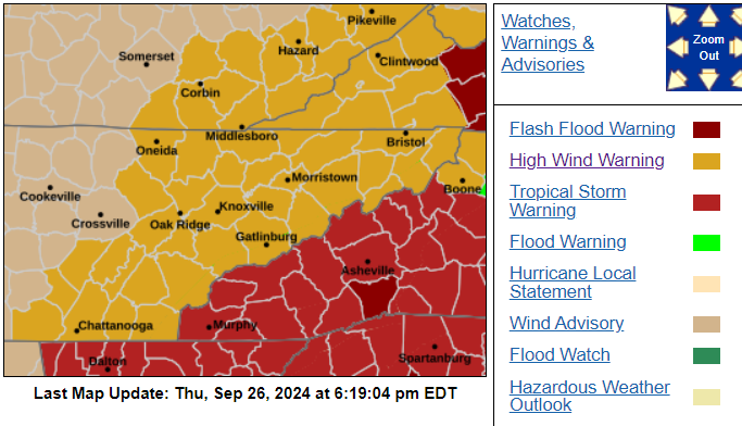
- 688 replies
-
- 10
-
-
- heat
- thunderstorms
- (and 7 more)
-
I figure the rainy falls were amplified and unsettled patterns, vs dry northwest flow or ridge. Helene is just one event and from the tropics. I'd kind of like to see mid-latitude drivers. For now I have warm La Nina. Secondary cold push pattern might benefit the Mid South more than the Eastern Valley. I'm mentally prepared to get blanked again. I mean Heather last year, six inches in Soddy Daisy and nada East Brainerd. My level of jaded remains off the charts!
-
Nice @Holston_River_Rambler looks like an impressive trip! Bonus Aurora in the Southwest, ha. Lots of stars at night. You drove the Million Dollar Highway? No guard rails it's white knuckles.
-
Summer-Fall 2024 Weather Disco Med/Long Range
nrgjeff replied to John1122's topic in Tennessee Valley
Reasons why I have not been on much recently.. They got the hole over East Brainerd, east of downtown Chattanooga. The totally whacked thing is that it's probably right!
- 688 replies
-
- 2
-

-

-
- heat
- thunderstorms
- (and 7 more)
-
Summer-Fall 2024 Weather Disco Med/Long Range
nrgjeff replied to John1122's topic in Tennessee Valley
After reasonable dewpoints, Debby finally dragged in the soup for Chattanooga today. Hopefully the last of the truly nutty dews. Temps and humidity will ebb and flow, more to the hot side than hot through August. I just see a hint of the light at the end of the tunnel. Next week will depend on where that boundary and scattered t-storms develop. Then the central US ridge gets more nibbles on both edges, which would help us esp. East Valley. Mid-South may still be closer to mid summer for a couple weeks. I have been out for a while. No trouble just lots at work and a last family trip end of summer break. Back to it now. Hope all are doing well here!- 688 replies
-
- 8
-
-
- heat
- thunderstorms
- (and 7 more)
-
Summer-Fall 2024 Weather Disco Med/Long Range
nrgjeff replied to John1122's topic in Tennessee Valley
Omaha was hawt Monday night! Of course Tennessee won in the Vols way. Let them almost come back and give fans heart failure. Likely watered my lawn for the last time of the season too. We have a chance of rain on Wednesday. Then per usual tough love intensifies into July. Might water it one more time, but frequency drops from every other night to every 3-4 nights (longer though). If this crap continues after July 4 it's a lost cause. Declare independence from watering. It'll come back in Sept. Some of the long-range models and weeklies have temps closer to normal the 3rd week of July. Oh great, when it's hot anyway.- 688 replies
-
- 2
-
-
- heat
- thunderstorms
- (and 7 more)
-
Summer-Fall 2024 Weather Disco Med/Long Range
nrgjeff replied to John1122's topic in Tennessee Valley
Yes so far temps are under achieving the hype. Core ridge is north, so I guess it's their problem. Lack of rain is verifying though. I have a feeling Sunday front attempt will be dry; first attempt often is dry. Then by midweek maybe the second try. Looks like front vs soft underbelly. Probably same result this time of year, more humid. Front would have pooling moisture. Yard could use the drink though. By next week yards will be very thirsty. Then we have hints at a hot 4th of July week. Weeklies are a little more reliable week 3 in mid-summer vs spring and fall. Guess from there we grind it out until football starts.- 688 replies
-
- 4
-
-
- heat
- thunderstorms
- (and 7 more)
-
Summer-Fall 2024 Weather Disco Med/Long Range
nrgjeff replied to John1122's topic in Tennessee Valley
Sunday we specialized in orphaned anvils around here. Finally got a shower Sunday evening. Coming on midweek we just have too much ridge in the Valley. Farther west the Mid-South has a little moisture fetch coming around the west side of the ridge. Might take until the middle of next week to break the ridge. Looks like it'll come from the soft underbelly. Front, what's that?- 688 replies
-
- 4
-
-
- heat
- thunderstorms
- (and 7 more)
-
Summer-Fall 2024 Weather Disco Med/Long Range
nrgjeff replied to John1122's topic in Tennessee Valley
Rocky Mountain and Northern High Plains things. I'll confess I'm jealous. Feel free to react- 688 replies
-
- 2
-
-
- heat
- thunderstorms
- (and 7 more)
-
Summer-Fall 2024 Weather Disco Med/Long Range
nrgjeff replied to John1122's topic in Tennessee Valley
Been a nice early June. Dewpoints are quite lovely today. Feels very comfortable outside. Unfortunately the gig is up starting about this weekend. Temps will bounce Thursday and Friday, but the humididy might lag a day. This weekend one needs to be near water. By late June looks like a true heat ridge will be sloshing around the US. Oh goodie!- 688 replies
-
- 3
-
-
-
- heat
- thunderstorms
- (and 7 more)
-
Summer-Fall 2024 Weather Disco Med/Long Range
nrgjeff replied to John1122's topic in Tennessee Valley
Tis the season for high-resolution models to be clueless. Today the rain was supposed to be MS/AL. It's Tenn. Love it!- 688 replies
-
- 5
-
-
- heat
- thunderstorms
- (and 7 more)
-
Summer-Fall 2024 Weather Disco Med/Long Range
nrgjeff replied to John1122's topic in Tennessee Valley
Wake me up when September comes.. Green Day is timeless. This thread should probably be pinned. Drop the pin on the Spring thread and put it out of its misery, ha. Still looks like we can avoid major heat for a good chunk of June. The more weeks we chop off the less miserable summer overall.- 688 replies
-
- 3
-
-
- heat
- thunderstorms
- (and 7 more)
-
Apparently West Tennessee had some landspouts over the weekend. I have seen few if any pictures on social media, but MEG did address questions.