nrgjeff
-
Posts
4,261 -
Joined
-
Last visited
Content Type
Profiles
Blogs
Forums
American Weather
Media Demo
Store
Gallery
Everything posted by nrgjeff
-
I'm woefully behind on the Forum. Missed the severe weather last week. Keeping it simple. Thunder then Snow. Tee it up! Saturday severe: Midweek hvy snow risk. They're not taking that into Chatty Day 7 (climo) but North Bama and North Ga are totally in play. :
-
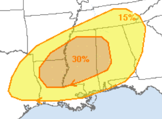
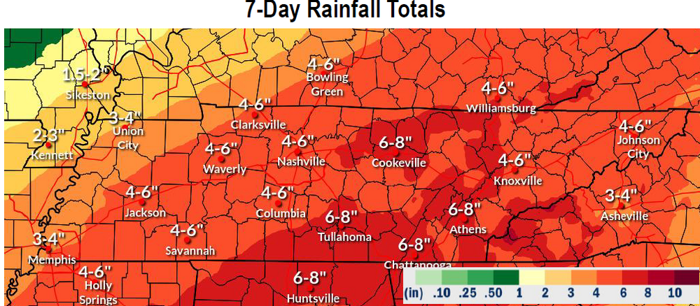
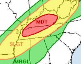
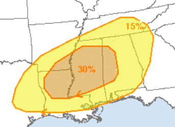
I was skeptical a few days ago but this 7-day chart may well verify. South end has received over half already. North side should get slammed over the weekend. The current (Feb. 12) for Saturday Feb. 15 WPC excessive rain is below the older QPF forecast. Today's excessive rain Feb. 12 is Slight northern MS/AL/GA and some southeast Tenn. Excessive Rain, not severe wx, for Saturday Feb. 15
-
Saturday looks like two rounds in the Deep South. A few weeks later in the season this system is strong enough to recharge for Round 2. As it is, the earlier may stabilize things north of US-82 Miss, I-20 Bama. Also looks like round 2 at night, so stable would be good! Then I-40 looks like another huge slug of rain. WPC has them getting more than southern Tennessee did early week. We'll see. Either way many folks are racking up impressive 7-day totals. Threats seem to all come together! Severe Sat. Feb. 15
-
Would have made a great time-lapse. As for 30 dBZ gettin' blanked, that's frustrating.
-
Valentines Day and Presidents Day have been good to me both in Appalachia (skiing) and back in the Plains growing up (imby). One year I failed to prep my Valentines for school. Rescued by a snow day! As for the 11-15 day period, most AI versions of Ensembles ooze the cold east eventually. GEFS does too. EPS and AIFS are a little slower and start warmer. EC warmer than USA stuff is kind of back to normal. I figure a slow go but eventually cold finds its way back in here. Favors BNAwx timing after the 11-15 day, more toward Day 20. We're also waiting for convection to gtfo the Maritime Subcontinent. When it shifts we can perhaps get more love from the MJO, again that Day 15-20 timing. Weekly models like days 15-20 also.
-
Severe thunderstorms would solve the problem. Just sayin' on Free for All Friday!
-
Virga passed over Chatty. It was actually pretty from the Interstate but I could not safely take a pic. Also not pictured, a small pile of snow remains at the shaded corner of my driveway from Fri. Jan. 10 snow. Two weeks!
-
Well Florida had its snow. SoCal be like, it's our turn! Sure beats fires. Perhaps that Western and Plains cold can ooze east to us in the 11-15 day. Guess we have to get through the thaw first. Baby steps.
-
12Z ECMWF is serving up the ol' Thunderstorms then chance of snow a few days later. Snow part is I-40 north. I'm less interested in an 11-15 day forecast than I am that I-40 is the usual routine. Even the thunderstorm part is a week or more out, and more likely Deep South than or forum. Mississippi maybe, but going into central/southern Alabama is Southeast.
-
Yeah my general rules are the following. 1. If we need cold air for snow we will get a warm nose. 2. If chasers want moisture return we will get cool dry air. Getting serious I think 2024-25 winter so far has been a wild ride from Nina to Nino influence. MJO been hoppin' and mixin' it up. Makes life like a box of chocolates.
-
If the above does not work out we may have to wait a while. Below reeks of plenty of column moisture but too stable, poor low-level return. Apps surface high blunts the goods. Oh but the said high would tempo weaken and allow a damn warm nose if we want snow. So, color me pessimistic snow to severe. Sorry Default Jeff is back.
-
 When it's very cold I think you can get it to snow up there if you sneeze in the right direction.
- 207 replies
-
- 3
-

-

-
- obs
- light snow
- (and 2 more)
-
I used to live on the southeast corner of the US-59 and I-610 interchange, some apartments tucked in there. That building was out my window from the other direction. Never imagined I'd see something like this! How about 27 deg. SN+ at Hobby! That's not Southern slush. That's Midwest powder, and a lot of it!
-
Mid-level clouds Chattanooga. Houston Hobby (middle of town) 27 deg. SN+ which is unbelievable down there. Not wet snow. Dry blowing Midwest snow and 4+ inches coming. Isolated 6 at those ratios. Then 6+ is coming to Nola. Time to live vicariously in the Central/West region. Blizzard Warning Gulf Coast Beaumont to Lake Charles! This a truly special event down there.
-
Fall/Winter Banter - Football, Basketball, Snowball?
nrgjeff replied to John1122's topic in Tennessee Valley
Excellent. We need to look out for our neighbors in NE Tennessee and WNC still left out in the cold (literally by FEMA) after Helene. Yeah that's weather related. Our church partners with another down the street when disaster strikes Chattanooga or the region. We must help! As for sports, snow both NFL games today. Winning! -
Chatty had flurries and snow showers during the 4:00 pm hour. Not much attm. Oh yes, everyone please post more slow-motion snow videos. Slo-Mo is the new obligatory deck photo, haha!
- 207 replies
-
- 10
-
-

-

-
- obs
- light snow
- (and 2 more)
-
Keep getting well BuCoVaWx. Perhaps a wild winter will bring cheer. I joke about Chattanooga, but we're playin' with house money after January 10th.
- 207 replies
-
- 6
-
-

-
-
- obs
- light snow
- (and 2 more)
-
Guess what's happening in Chattanooga. Cloudy, windy, and cold. Nothing more than a few snow grains.
- 207 replies
-
- 7
-
-

-
-
- obs
- light snow
- (and 2 more)
-
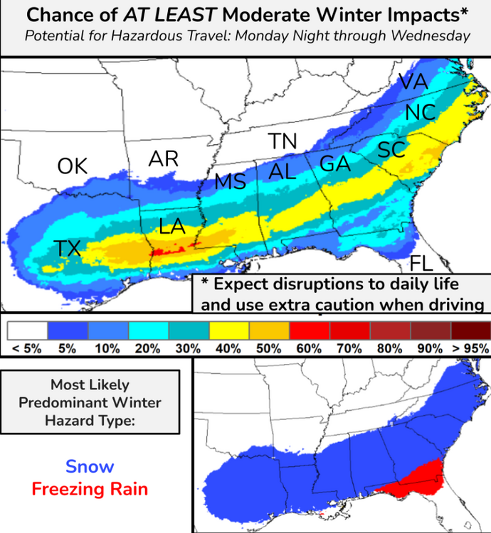
Severe weather baby! ^^ Alright to Tuesday. Gonna let Sunday live in the Jan. 19 RGEM thread though I know it's flexible. Looks like more like moisture will be around for light snow in more places on Sunday, but it's covered in that thread. For Tuesday I share the probability of WS Warning from WPC. The cut-off at Tennessee isn't a jinx, haha. Alabama and Georgia have that low 2-inch criteria. So if there's nearly a 30% chance up on the Tennessee border; then, maybe a little light fluffy snow East Tenn. Again this is for Tuesday and Tuesday night. End of NAM (I know lol) hints at a little more moisture up our way like the Canadian. Otherwise we'll be happy for the Deep South. I'd pick Birmingham over ATL because nothing ever goes right in ATL. Also be north side of centerline, but yeah ATL looks good this time too.
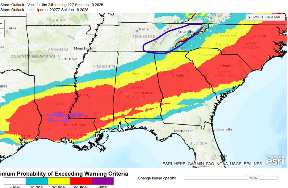
-
WPC tease me and maybe even please me. That's moderate impacts. Light impacts probs are likely higher. Fluffy snow doesn't do much except for roads. Reel it in! Then North Florida Red Alert. Icemageddon!
- 207 replies
-
- 3
-
-
- obs
- light snow
- (and 2 more)
-
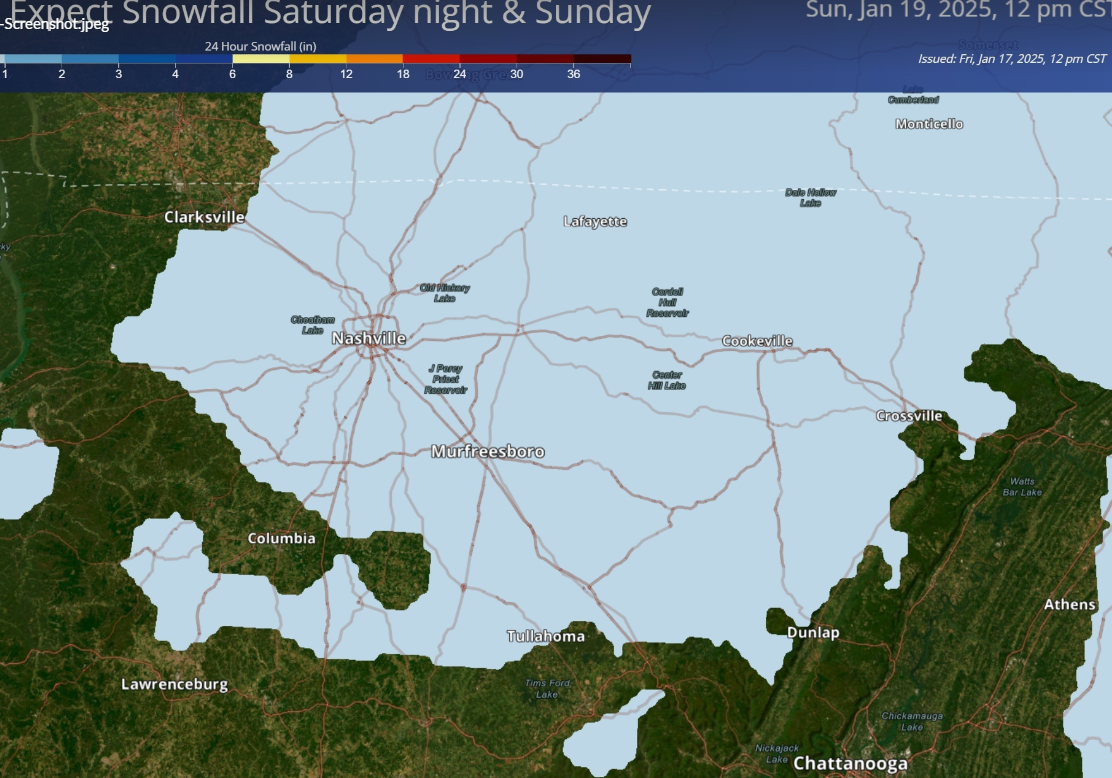
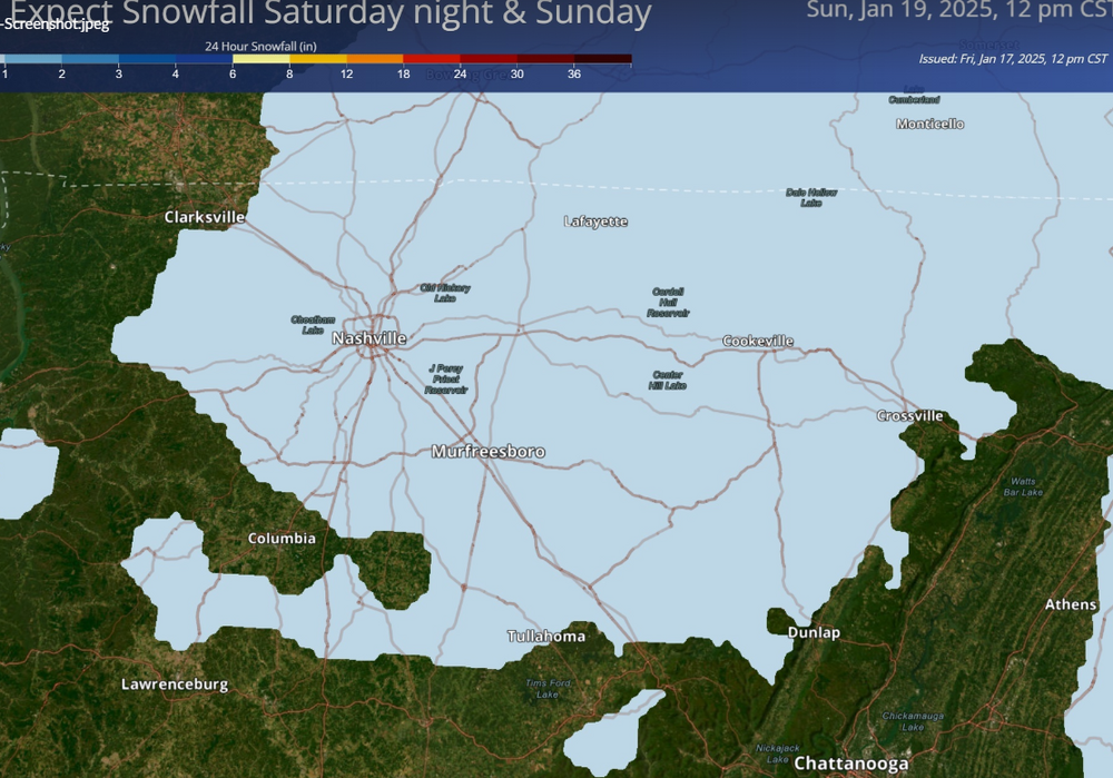
Nashville just dropped higher snow probs. Surely this is coming to their public site soon. Ope! I cut off the scale, inch or less.
- 207 replies
-
- 5
-
-
-
- obs
- light snow
- (and 2 more)
-
Indeed it's nice to be playin' with house money. Southeast Tennessee certainly is, even if other parts of the forum don't feel the same (yet). If we get it great! If not I'll be happy for the Deep South. But yeah, I think we have a shot still. I figured you were. Great stuff! Soon, maybe as early as in February, we can focus on the Dark Side of the Force.
-
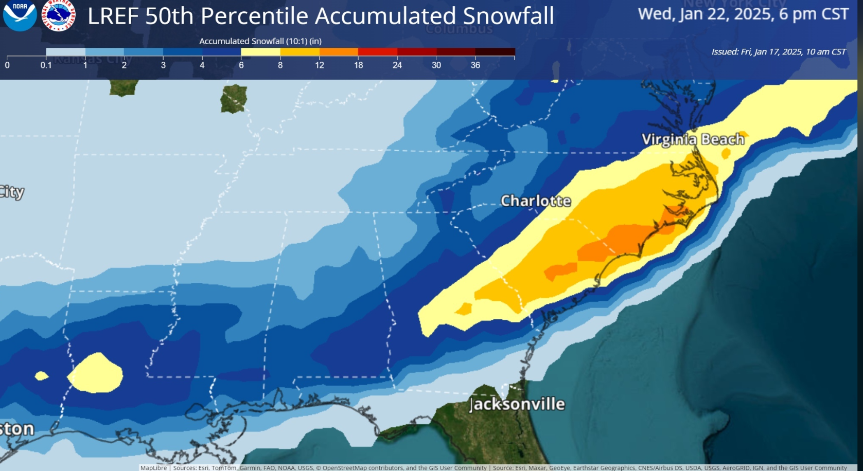
Let's try this. It might be fixed last page too. Model trends are south for Tuesday. Sometimes the Deep South gets it and we don't, so we can be happy for them. I don't even want to look at the late week mess. There is still a chance Tue/Wed though. LREF from NWS. I'm not sure where this lives on their website so I'll share.

-
Yes because we are buried in Arctic high pressure during the middle of the cold wave. Model trends are south for Tuesday. Sometimes the Deep South gets it and we don't, so we can be happy for them. I don't even want to look at the late week mess. There is still a chance Tue/Wed though. LREF from NWS. I'm not sure where this lives on their website so I'll share. PS. other Pinned thread is just for Sunday right?

-
Don't worry I'm still Snow Jeff. I was just lmao to see others jawboning severe. My favoring the Canadian model is for that snow up into Chattanooga, and elsewhere in our Region. Oh Canada!