nrgjeff
-
Posts
4,251 -
Joined
-
Last visited
Content Type
Profiles
Blogs
Forums
American Weather
Media Demo
Store
Gallery
Everything posted by nrgjeff
-
Wednesday looks meh. Later in the season I'd hope for a mesoscale accident, but NCAA play-in games look like a better option. Sunday Deep South is looking more poorly oriented. Still early in the season, but I have concerns SSW could kill the first half of April. Later in the season a -AO can help get the jet stream going. This early, it's crap.
-
My device almost didn't survive the last two posts. Absolutely hideous for storm interests! In 7-10 days the window slams shut for perhaps a while.
-

Fall/Winter Banter - Football, Basketball, Snowball?
nrgjeff replied to John1122's topic in Tennessee Valley
Auburn will be prepared though. I have Auburn and Duke on two brackets. Alabama depends on who shows up mentally. Kansas will lose round 1, probably won't even get to the weekend. Tennessee will probably make the Sweet 16 and then break Vols hearts. -
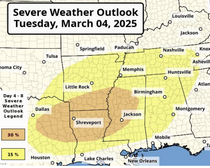
High Risk and PDS boxes are warranted. Ugly afternoon on tap.
-
If chasing it's a good idea to pick a side of the Mississippi River (or Missouri River, any river) and stick to it. Don't get into a safety jam because of the River. Always have TWO escape routes. I like east and south. River typically cuts off one, but I can't accept that. So, chase is done before the river. Otherwise one can wait on the Illinois side (other side of whatever river) and let the storms come. Better yet, stay home and enjoy college basketball.
-
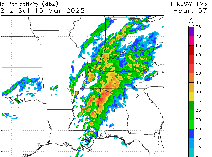
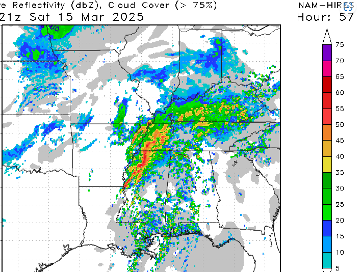
Hopefully it busts like May 20, 2019. That HRRR isn't gonna be good for anybody. Image below.

-
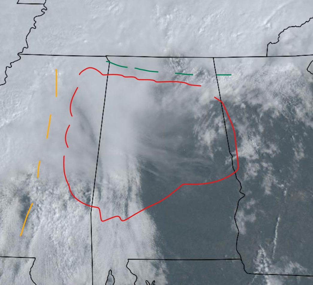
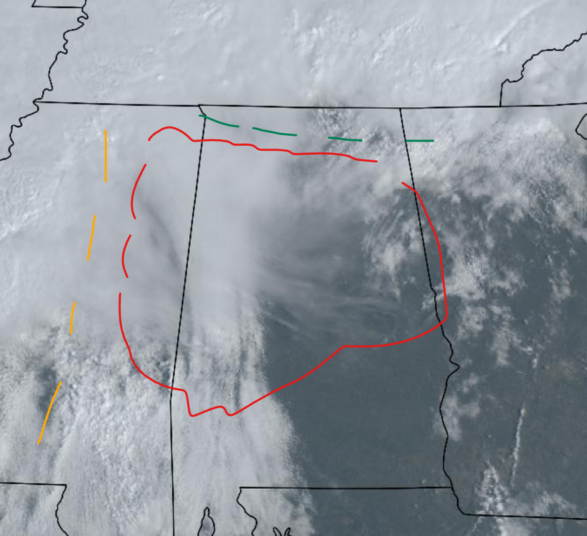
Latest data indicates quite a day around here on Saturday. Andy and David are right about the model biases, but even considering that, the 12z Thursday suite looked pretty ragged. 00z Friday is a different story. Thunderstorms continue or develop predawn Saturday. They may start rotating right then. However it's really sloppy. Then by midday - with no diurnal pause - everything just starts rotating. We'll see. It's happened before and it'll happen again in the South. Looks hideous for chasing. Looks even worse for the general public. Saturday is lookin' like college basketball for me. Sky stayed clear for the total lunar eclipse. 2025 is starting like 2024. Punting storms and enjoying astronomical events and the night sky. Lunar eclipses are underrated. It's not solar spectacular - but it's beautiful! and Peaceful.
-
The CAMs I see scream, watch college basketball. GFS is just as messy and the Euro is near rainout. Nothing here looks like chase material. Good news if you are storm anxious though. For chasing Flash probably has the best plan on Friday.
-
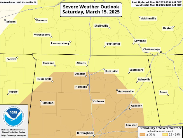
Southern Illinois isn't great south of I-64 but improves markedly toward I-70. Any of it is better than central Alabama. My most likely TOR threat Saturday is wherever the outflow sets up. Right now I think the north border of MDT with ENH. So that's south of the favorable part of North Bama. I'll be shocked if Tennessee clears out.
-
Tough to reply. What model is that? I was actually starting to get bearish for Saturday slop, but Andy showed up. Stop by more often. That's usually a bullish sign! ECMWF LLJ is more backed which gets t-storms going earlier and more widespread. That's a messy no chase scenario for me. GFS appears to have more just right parameters including destabilization. 12Z CAMs go out 60 hours and none are too inspiring for chasing. For those with storm anxiety, perhaps we can get a big sloppy line to cut down the supercell risk. The other scenario we've seen is that these models key in on more breaks of sun, destabilization and just right (breakable) caps. Might look for those trends tonight or even 06/12Z Friday. This is all for Saturday. Friday night looks pretty straight forward. Broken line out of Missouri will blast into IL and KY. Decay of that into the South will determine much on Saturday. It is no 2011. We'll see if it even becomes anything.
-
A look at the 84 hr. NAM - not yet reliable for surface beyond 60 hr. - shows an upper level regime somewhere between that of the GFS and that of the Euro. Note the globals are 06Z. GFS has robust instability, and still enough turning with height. Euro is not quite as unstable, but the turning with height is greater. 850 is about 10-20 deg. backed from straight south. Others are not. So two paths are offered to high overall parameters. All have a distinct Saturday short-wave. Surface is still TBD. Friday night into Saturday morning convection evolution is TBD. Without those pieces I don't consider siggy severe locked in. It's on the table though.
-
If the 12Z Tuesday forecast holds. Saturday is going to be a day. CSU model is probably keying in on outflow in Bama. Plus that surface low. Mass response (LLJ other levels) has trended up on Saturday due to the more obvious 2nd wave at the upper levels. Also the reason for the surface low. It's all connected.
-
Saturday the South is going to get its own short-wave. Vort lobe should eject from the Plains trough. If trends hold we have less morning rain forecast. First short-wave is long gone over the Great Lakes. Two in a row is usually heavy rain, but not with this separation by almost a day. Instead we may have a couple outflow boundaries cooking all morning. Seems early in the season, but that's what might happen. Then by Saturday afternoon.. I will be very interested in any intersection of outflow boundary and pre-frontal trough. Such surface details can't be discerned 5 days out, but the background parameter space will be robust. Outlook for Saturday
-
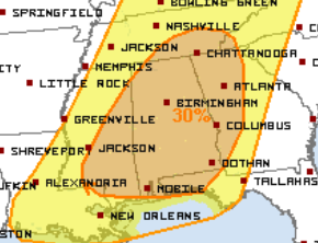
I'm putting in an order for an outflow boundary in North Alabama. Sure as hell is not a forecast 6 days out! Reality is we get what we get and we don't pitch a fit. Could still be a Deep South MCS nixes Saturday. Though Friday looks robust into the Mid-South, Saturday is my main interest. Looks like two pieces of energy. Friday lobe ejects from the Mid-South to the Midwest. Another jet streak and lobe of energy is forecast into the Deep South on Saturday. Outflow placement is highly dependent on Friday - which is still Day 5. Honestly I would have waited on 30% for Saturday. Friday is legit 30% though. I know parameters are nuts, but the other solution is MCS rainout. Upside of course is less am rain and reload.
-
Models refuse to connect the warm Strato with the 500 mb level. Could be yet another one that just fires blanks. Next path to cod might be the MJO and increasing GLAAM. However by late March I don't want that. Who really wants that? We're ready for spring. I'm ready for other things associated with spring too!
-
Time period from about March 15 looks active. Some models have a classic Southern slam. Others bring it out in two pieces with slow moving heavy rain. 10 days out there is little else to discuss yet.
-
Sorry y'all I brought the synoptic wind from Kansas.
-
Indeed we have more cold fronts coming. I may be over 32 but it's not over for the Valley. Start with later this week. Then the strato forecast is back after a flop. See how that goes later in March. In between the two? See severe wx thread for next week too.
-
Yeah I'm over talking about 32 deg. Let's talk about Td 68 deg. And off to the severe wx thread.
-
Tuesday will likely be intense along and south of US-82 where breaks in clouds prime things. Even possible up to I-22. Basic pattern recognition shows Tuesday will be an event. Details are TBD. NAM will become useful inside 36 hours. Same with the ARW. Should be 24-36 hours for FV3. I'd wait until 12-24 hours for the HRRR and RRFS (if it even updates).
-
Well then, getting right into the heart of our Regional forum. Need the Western Crew to join the party!
-
Yeah the SSW busted. Now there is talk about an MJO driven event from below, with strato reflection. That's a lot that has to go right. MJO convection is split, so I'm very skeptical.
-
Tee it up! South is probably appropriate with multiple rounds. Wherever the outflow sets up, is gonna light up!
-
Following some cold this weekend and again late next week.. All weekly charts have a marked shift to trough west SER for the middle of March. Fly in the ointment is an attempted active strato. Otherwise it could be stormy Too early to know if that's the MId-South or MIdwest early season chasing, but buckle up!
-
I chase at night. I chase in the jungle. I chase in the hills. I buy stocks during bear markets. All about risk tolerance. Oh but 3/4 are not true above. Also it's too early to time it.