

nrgjeff
-
Posts
4,261 -
Joined
-
Last visited
Content Type
Profiles
Blogs
Forums
American Weather
Media Demo
Store
Gallery
Everything posted by nrgjeff
-
Y'all are starting to sound like me! Welcome to the Dark Side. AI versions pretty much followed their ops versions. Whatever. I'm going with the Canadian. Sounds good, eh?
-
Canadian was first to sniff out Mid South clearing for the total solar eclipse. Oh Canada baby!
-
Laugh. Cry. Throw the device. One reality check is Tennessee Valley temps are not forecast as cold as with Heather and Elliott. Perhaps that's less support for a snow down on the Gulf Coast. Of course they could get a bowling ball in the southern stream. Then if we get something as the jet stream lifts back north, I will vomit if we get warm nosed. Still holding onto a middle scenario with light snow for Tennessee midweek.
-
Model spread has gotten worse the last 12-18 hours, but that does not necessary decrease our odds of success. Appears the middle solution is still a chance of snow. Between Deep South blanks Mid-South, and that atrocious warm nose crap late week, there is a mid-point of light snow southern Tennessee midweek. Of course, all of our Region is clearly within the bell curve. If all else fails. Shit my brain is oat-meal from looking at models. WPC has a 30% chance of snow in the Deep South Days 6-7. North side clips us. One would have to include all of us in the 10% north side. The other 10% is snow south of I-20 and Deep South mayhem. My professional focus has to be temperatures next week; so, I'm not drilling down the snow forecasts more than once a day. We are watching temperature forecasts like hawks. If this thing develops, I'll have a lot more on snow this weekend.
-
The PWAT charts above do not kill Tennessee snow chances. Remember snow, especially dry snow, carries very little liquid compared to rain. I hope central Mississippi can score. It's even more magical in the Deep South. Then I want to get TROWAL'ed over here in East Tenn. TROWAL me! Talk dirty to me.
-
The 18Z GFS can go to Hell! Meanwhile AI versions of both continue to improve and jog north. If we go from I-20 to cutter before it gets here, I'm going to quit the forum. I believe one wave will settle in well over us. I still think the Deep South could get one before us too. This far south jet stream would be their pattern. On the retreat north we can score as long as it's not too north like 18Z. Consensus remains good or even south - right where I like it a week out.
-
Solid until - unlikely we receive much. Though at 25 deg. a tenth inch QPF is 2-3 inches of snow.
-
Models have been improving the last 12 hours since my last post. Looking at Ops AI and ensembles. 06/12Z GFS have a true TROWAL behind the main WAA later this week - a recipe for several inches of snow. Other models have light overrunning. Few blank us now. Few details. Work is really busy. I'm also following current events - but for that you'll have to visit Randy's hood to see my thoughts.
-
Model trends encouraged me today. Per my last post, I'm much more interested in midweek than Sunday. Southeast Tennessee needs a new system, not one chasing the Saturday rain. Ensemble members and some ops and AI runs are delivering a midweek system. Others keep it buried in the Deep South. Again I'd much rather be concerned about moisture getting north, rather than warm noses and cutters. That's all for today. Long day at the office, but I was watching trends. I'll sleep happy tonight.
-
12Z Canadian shows ice! What is that Trudeau's retaliation? GFS and Euro I see Sunday as the first chance of winter precip. Perhaps late Saturday night northwest so that's still Day 7 as of this writing. I like the Peachtree discussion. At the same time the ensemble snow means are increasing per Carvers above. Personally I'm hoping for something the middle of next week to show up in the flow. Sunday is way too soon after the rain system for KCHA. We'll be fighting subsidence behind the first system; plus, anafrontal is DOA for Chatty snow.
-
Strange. Hall is never bullish about anything. Chattanooga probably has reached our half-way point even if the good models verify. Other parts of the forum may be just gettin' started. We'll see.
-
Even that 12Z GFS verbatim, buried in the Deep South, more snow than progged would get up and over us. Northern stream, maybe instead of warm nosing us, could do something productive (for once) in that setup.
-
November snow in Florida! per a few posts up. Guess anything can happen in this business. Quick look at the medium range models and most bury any waves. I'd much rather see that than cutters. Perhaps one will develop in our sweet spot. A couple AI versions have just that. Right after the Saturday rain, but separated enough to develop, second wave Sun/Mon.
-
Maybe we can get some severe weather going on Saturday. OK I'll be good! Oh the EC for Tuesday Jan. 21 is lovely. Full thickness is 522 low lower. You wouldn't think we'd get a warm nose, lol! Partial thickness lines are buried in the Deep South - where they belong. 700 mb is a proper -10 to -15. That's Day 10 counting Sunday as Day 1. Long way to go. Broad theme is waves will continue on a buried southern jet vs all NW flow.
-
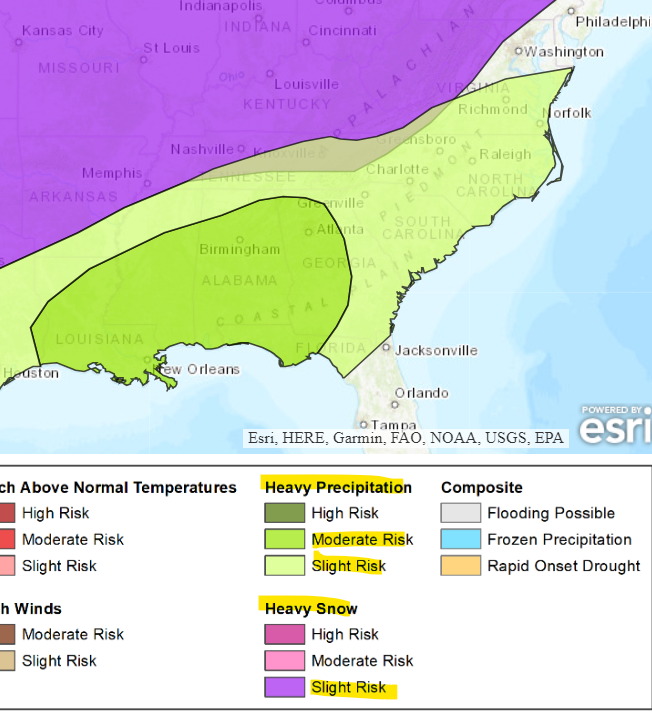
WPC/CPC risks at the same time periods Jan 18-24. What could go wrong? Please no ice overrunning. Can we order up more snow? With the jet stream buried and roaring, things may show up inside 5 days at any time.
-
 Either that or they check at 11:59 pm in which case everything got compacted. Yeah I see the snow and snow on ground, but I got 5.5 inches in three very different spots in our 'hood. This was at peak fluff and quarters ripping. It immediately settled with the dreaded sleet and then light freezing rain. That said, we hit snow stretch goal before the mixer mayhem, so I'm happy with the event in KCHA
 -
Euro is generally better with the MJO but it struggles in a couple phases. Always a trade off with NWP. Regardless they both stay cold CFS/EC weeklies. Friday was terrific in Chattanooga*, but I still want more snow! *yes the sleet was disappointing and ate up QPF, but we hit our snow stretch target first!
-
We needed much thicker multi-layered clouds like this morning @midwoodian behind the dry slot to get it to change back to snow. Most of the afternoon junk fell from a layer of lower clouds, below the snow production zone. The other storm thread (whopper) has a good discussion of this matter pages 13-14. DGZ dendrite growth zone, and an MRX discussion. Thankfully we got a good snow before the ice to dry slot. If you're getting snow this evening on Signal it's probably the ol' Signal microclimate. It's 33 and drizzle in town. I'm signing off for the night. Cheers to all!
-
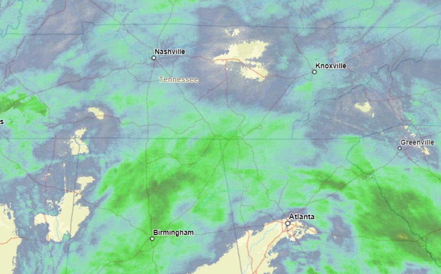
Dry slot over I-75 southeast Tenn. CHA-TYS at this moment. Late afternoon break or end of storm? Looks like it wants to fill in again west, and/or sink south from the Nashville shear band. Trouble is a lack of middle level clouds (upstream). We need a deeper cloud deck to produce snow. Clouds won't have to be as deep as before, but we need more than what's incoming. Might even be a break north of I-40 east of the Plateau but that area has a better chance of refilling. It's still snowing in Nashville.
-
Yes I got 5-6 inches measured in three places while it was still rippin quarters and some half dollars. When it stopped it settled about an inch. Then the sleet really beat it down. Glad we got out at peak snow rates, just down the street.
- 475 replies
-
- 16
-

-

-
Nah we're golden! Big slug of moisture, isentropic lift and CSI incoming.
-
Moderate snow in Chattanooga with 2 inches on the ground. Need the precip type to hold the line.
-
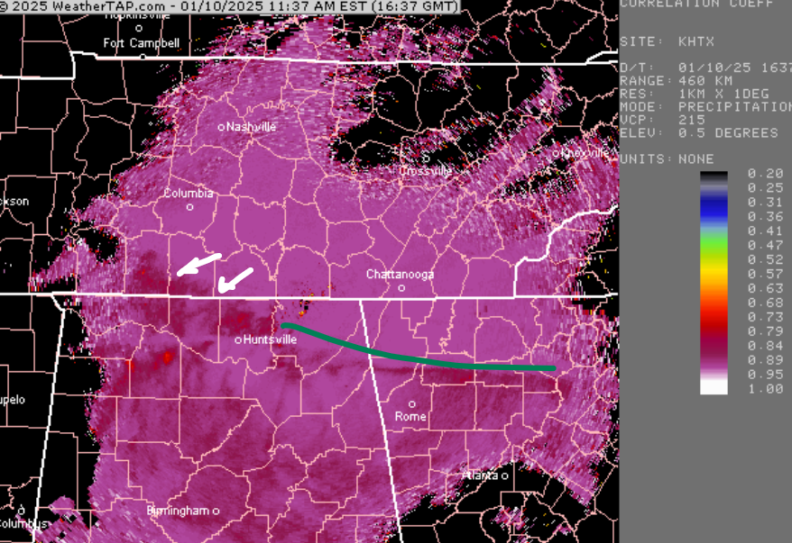
Getting on 2 inches Chatty. Excellent news out of Hytop. Though the green line is trying to advance, snow is holding the line east of I-65 in southern Middle Tenn. When the mix tries to advance snow pokes southwest.
-
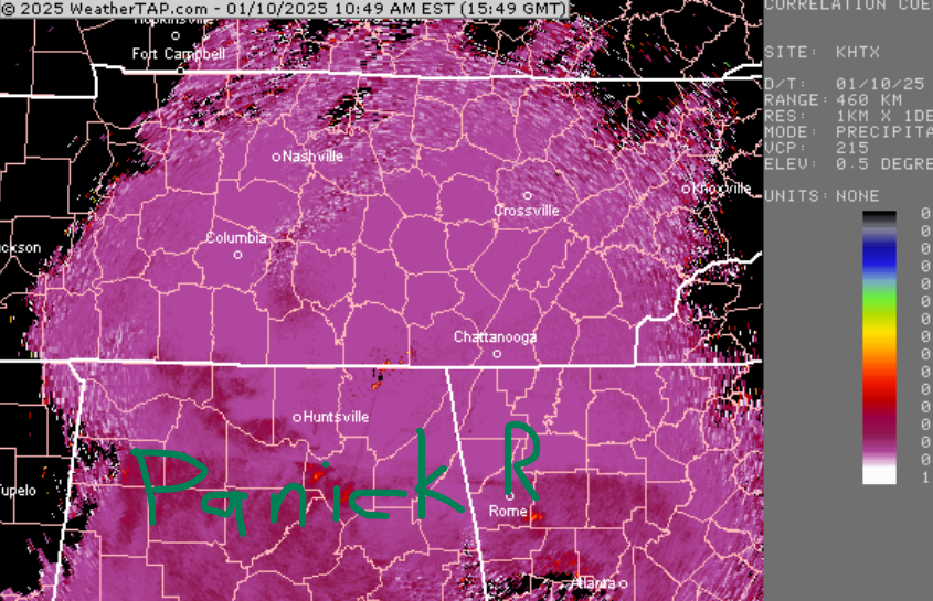
I'm pretty sure the earlier week snow was produced at lower levels, and John know this already. But yeah these traditional snows are like waiting for the big game to start. Northwest Alabama, no. Chatty flakes are still not the phat quarters I'd imagined. Correlation coefficient is still PANIC ROOM like nursing a 3 point lead with 8 minutes left in the game.
-
Yes Chatty is getting light but solid snow. Moderate SN is incoming. Huntsville 30 and all snow is very encouraging up our way. Thank you!


