All Activity
- Past hour
-

May 2024 Discussion - Welcome to Severe Season!!!!
Sn0waddict replied to weatherwiz's topic in New England
Sun is trying to poke through. Hoping we clear out in the afternoon. -
Pollen cleaner Looks like 0.75 - 1.00 inch next 3 days. Then later next week/weekend more rain. Dry streak washed away the next 10 days. Lets see if it goes from regular to deluge.
- 124 replies
-
- 1
-

-
- spring
- dry weather
- (and 3 more)
-

New England Met Spring 2024 Banter
Damage In Tolland replied to HoarfrostHubb's topic in New England
What are you into besides tracking rain events in winter? -
It is good sleeping weather but temps in the 50's and low 60's during the day (in house) is a tad cold.
-
More muck. 53 and cloudy.
- 124 replies
-
- 1
-

-
- spring
- dry weather
- (and 3 more)
-
My heater is on right now. Getting ready for the weekend.
-
59 and mostly cloudy east/onshore flow. Wetter cloudier period the next 10 days. Next warm day or day and half would be Tue (5/4)-Wed (5/5) next week.
-
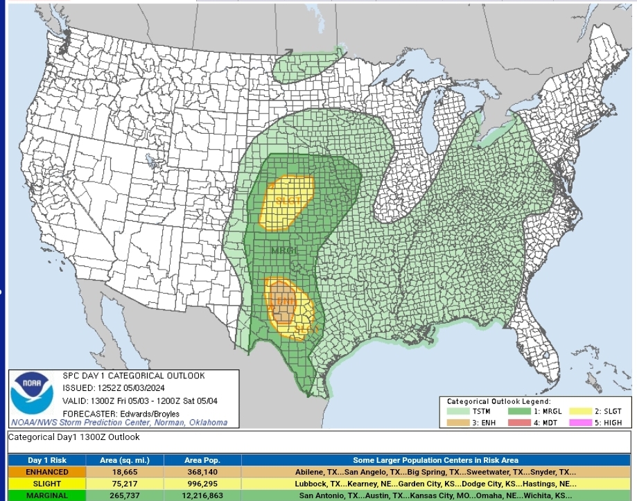
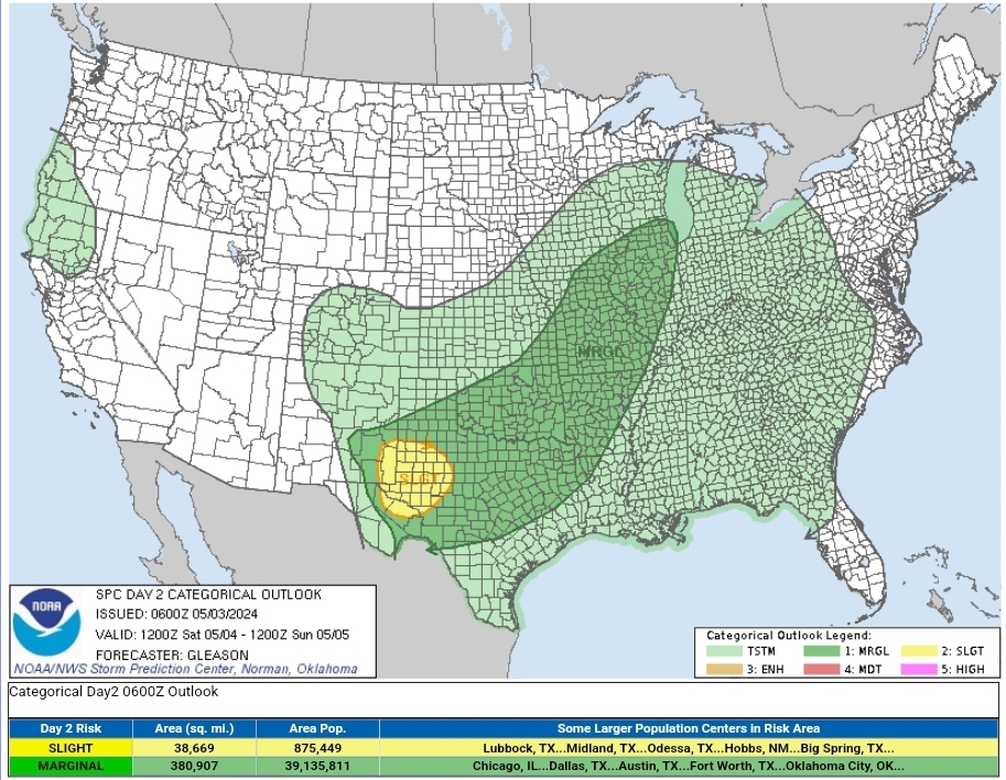
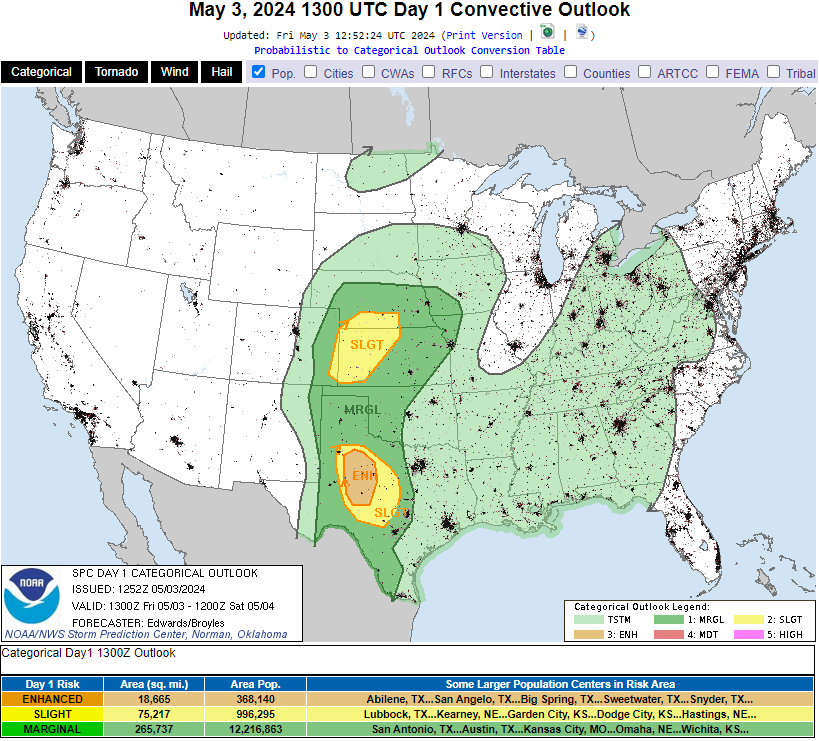
Added today's threat to this thread as well. Looks like a repeat of yesterday for Texas, with an added slight risk to western KS/southern NE.
-
Spongy moth hellscape around here
-
perfect sleeping weather
-
The heat will be on here tomorrow with temps in the 40's during the day.
-

Extended summer stormlover74 future snow hole banter thread 23
snowman19 replied to BxEngine's topic in New York City Metro
Here comes La Niña. We already have the strong -PDO….only question remaining….do we flip to a -IOD by fall, which will really kick this into overdrive? -
if i attemped to lght a fire my daughter would beat my ass. We both like it cool/cold
-
i knew i'd get some feedback for that, didn't think it would be that fast i was only kidding
-
This blurb from LWX sure sounds like next week could be stormy From Tuesday through the remainder of the long term period, the forecast area will be in the warm sector allowing for an increasing threat for strong to severe thunderstorms.
-
Start the fire!
-
100% Truth!
-

Central Pa. Spring 2024
Itstrainingtime replied to mahantango#1's topic in Upstate New York/Pennsylvania
Oh my. Say it isn't so, Jon... -
yeah, i was thinking of bringing a little wood in to take the chill off.
-
Central Pa. Spring 2024
Itstrainingtime replied to mahantango#1's topic in Upstate New York/Pennsylvania
I would just like to say publicly that as one of Joel Hans Embiid's biggest critics, I thought he played very well last night. A couple of careless turns, but last night certainly wasn't on him. I'm not one to hide when he plays well. Having said that - I do still fully believe that this team will not win with him. I've read too many accounts from people within the organization and guys like Pat Bev who have shared that Embiid is more concerned about his personal numbers than the team's success. Obviously, I can't verify all of that. However, when he raises his hands and turns them inwards towards himself...makes me think that all of those reports are accurate. The Sixers might have slightly better overall talent compared to NY, but what really stood out in that series was heart...will...desire...effort...outside of the 2nd quarter last night, we never matched the Knicks intensity on the floor. Loose ball? Going to NY. Hitting the glass? NY all the way. I don't like any NY team but if I was a fan of the Knicks I would absolutely love my team. Man, do they play with energy and effort. All the time. They're relentless. -
Yep, that's why I've been so hyped on this week. This is a gift. Our base state has generally been cloudy, though looks like we might get back into the warm side once the front lifts north again early next week. Hopefully, that leads to partly sunny and better storm chances.
-

May 2024 Discussion - Welcome to Severe Season!!!!
Typhoon Tip replied to weatherwiz's topic in New England
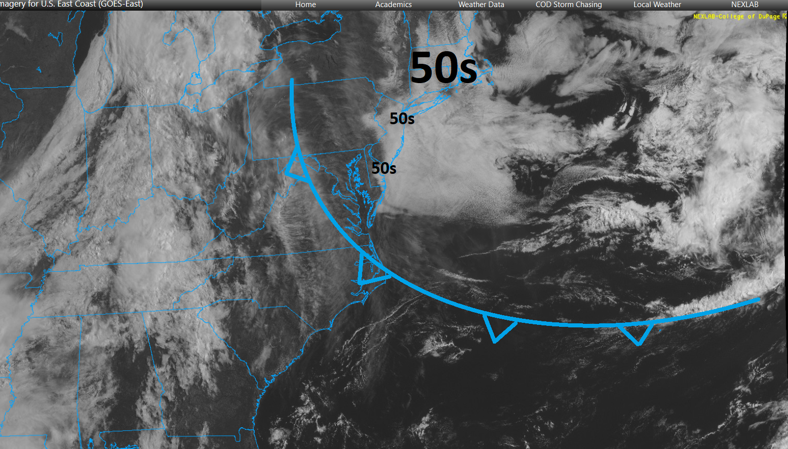
Man, this is may be a record breaking BD - if there were such a tracking... in terms of mass alone this thing is HUGE https://weather.cod.edu/satrad/?parms=regional-eastcoast-02-24-1-100-1&checked=map&colorbar=undefined
-

May 2024 Discussion - Welcome to Severe Season!!!!
NoCORH4L replied to weatherwiz's topic in New England
It's shitty from now through next weekend, let's just face the music. We now live in NL. - Today
-
Still a severe signal for a threat or two in the Tue-Fri timeframe. I'm not "super enthused" for our area. But stuff can sneak up on us. For now just bears watching. One of those days (or more) could perform. CIPS still has some indication.
-
Bi-modal D1 risk with the southern section upgraded to ENH. D2 slight for the Permian Basin area Day 1 Convective Outlook NWS Storm Prediction Center Norman OK 0752 AM CDT Fri May 03 2024 Valid 031300Z - 041200Z ...THERE IS AN ENHANCED RISK OF SEVERE THUNDERSTORMS FROM NEAR THE WEST TEXAS CAPROCK ONTO ADJOINING LOW ROLLING PLAINS... ...THERE IS A SLIGHT RISK OF SEVERE THUNDERSTORMS SURROUNDING THE ENHANCED AREA...AND OVER PORTIONS OF THE CENTRAL PLAINS... ...SUMMARY... Large hail and damaging gusts are possible over parts of the central/southern Great Plains from southern Nebraska to west Texas, along with some tornado potential over parts of west Texas. ...Synopsis... Today's transitional mid/upper-level synoptic pattern is a tale of two cyclones -- one astride the Upper Midwest/Canadian border, and another digging southeastward out of the Gulf of Alaska. The broad, complex leading cyclone will eject northeastward over MB and northwestern ON through the period. A trailing shortwave trough -- apparent in moisture-channel imagery over parts of southern ID and northern NV -- will move east-northeastward to eastern SD and central NE by 12Z tomorrow. The strong, well-developed Pacific cyclone will proceed southeastward to just off the coast of OR by the end of the period. Southwest flow aloft will be maintained with weak synoptic-scale height rises over most of the central/southern Plains. Still, sufficient moisture, buoyancy, lift and shear are apparent for a couple relative maxima in severe potential as discussed below. At the surface, 11Z analysis showed a low attached to a cold front over south-central WY. The front should proceed southeastward through the day, extending from southeastern SD to western NE an central CO by 00Z, with the low over northeastern CO. By 12Z tomorrow, the front should extend from a low over IA to south- central KS, the northern TX Panhandle, and north-central NM. This front will overtake a developing dryline over the central High Plains from north-south, with the dryline position at 00Z over eastern CO, the western TX Panhandle, and Permian Basin. A weak/ residual, nearly stationary front extended from a low near FST northeastward across northwest TX, eastern OK and the Ozarks, and should continue to lose definition amidst considerable convective outflow. The southern rim of that outflow was evident from southeast TX (between GLS-BPT) across the HOU metro then west- northwestward to near SJT. The western part will shift northward slowly through the day toward the front, which itself should drift northward up the Caprock. ...West/southwest TX... Widely scattered to scattered thunderstorms are expected to form this afternoon near the dryline and the residual outflow boundary over the South Plains to Low Rolling Plains/Concho Valley regions. Isolated to widely scattered convection possible farther south off the dryline past the Rio Grande, and into strongly heated/CINH- minimized higher terrain of the Serranias del Burro range in northern Coahuila. This activity should move eastward across areas below the Caprock and around the Big Country to Edwards Plateau, with potential for some of the Mexican convection to cross the Rio Grande this evening as well. Supercells -- with large to very large hail and at least isolated potential for tornadoes -- will be more probable in and near the 30%/"enhanced" hail area. Dryline and orographic activity to the south will be an early hail/wind threat. Some of this activity may aggregate into clusters offering mainly strong-severe gusts, with one or two small MCSs possible this evening into the early overnight hours. Despite multiple days of MCS and smaller-scale convective activity to the east and southeast, a reservoir of rich low-level moisture remains not far upstream across south-central TX and into the southern Edwards Plateau, where upper 60s to low 70s F surface dewpoints and PW commonly 1-1.5 inches. When advected northwestward amid diurnal heating and beneath steep midlevel lapse rates, 3000-4000 J/kg MLCAPE should become common. Though low-level flow should not be particularly strong, it will be backed, contributing to elongated hodographs ad around 30-40 kt effective-shear magnitudes. Splitting storms may be common early, offering the greatest hail potential (size and coverage). The damaging-wind threat will be maximized on the mesoscale where organized cold pools can develop, and should extend farther east at greater density than the hail potential this evening into tonight. In the absence of substantial large-scale support, tornado potential will be locally maximized with any supercells that can interact favorably with outflow boundaries or each other. ...Central Plains... Large hail and severe gusts are possible from mid/late afternoon into tonight, from thunderstorms shifting eastward across portions of the central Plains. Though nowhere nearly as moist as the TX outlook area, a diurnally destabilized plume of moist advection should support a secondary relative max in severe potential along/ahead of the cold front and dryline from parts of eastern CO to western/northern KS and southern NE. Convection should develop by mid/late afternoon in a regional convergence maximum near and northeast of the surface low, with MLCINH weakened by favorable diurnal heating. Surface dewpoints in the 40s to low 50s F should be common, with steep surface-500-mb lapse rates, 500-1000 J/kg MLCAPE and well-mixed subcloud layers. Effective-shear magnitudes around 40-50 kt indicate potential for organized convection -- both in quasi-linear form near the front and initially discrete (but later merging upscale) off the dryline. Though activity will encounter a more-stable boundary layer with time and eastward extent across KS/NE, at least marginal severe-gust potential may last overnight as far eastward as parts of the Missouri Valley region. ..Edwards/Broyles.. 05/03/2024 Day 2 Convective Outlook NWS Storm Prediction Center Norman OK 0100 AM CDT Fri May 03 2024 Valid 041200Z - 051200Z ...THERE IS A SLIGHT RISK OF SEVERE THUNDERSTORMS ACROSS PARTS OF WEST TEXAS AND SOUTHEASTERN NEW MEXICO... ...SUMMARY... Scattered severe thunderstorms posing a threat for very large hail, damaging winds, and perhaps a few tornadoes should occur across parts of the southern High Plains Saturday afternoon and evening. Isolated strong to severe thunderstorms may occur across a broader portion of the southern Plains into the Ozarks, mid Mississippi Valley, and Midwest. ...Synopsis... A closed upper low will move east-southeastward over the western states on Saturday. Downstream, a shortwave trough will advance quickly east-northeastward across the Upper Midwest through the day. A related weak surface low should develop from IA towards IL in the same time frame. A cold front will extend southwestward from this low across parts of the mid MS Valley into the southern Plains. A subtle/low-amplitude shortwave trough is forecast to move across northern Mexico and the southern High Plains by late Saturday afternoon. This feature may provide sufficient lift to support isolated to scattered severe thunderstorms across parts of the southern High Plains Saturday afternoon/evening. ...Southern High Plains... A weak surface low should be in place over parts of far west TX and north-central Mexico through the day, with a dryline extending southward from this low. A southward-moving cold front should eventually intersect the dryline by late Saturday afternoon. Diurnal heating of a very moist low-level airmass and steep mid-level lapse rates will contribute to moderate/locally strong instability across west TX and southeastern NM. Convective initiation appears likely along both boundaries Saturday afternoon and evening. Although low-level flow should remain rather weak through the day, a favorably veering and slowly strengthening wind profile with height through mid levels will support around 35-45 kt of deep-layer shear. Robust thunderstorms that develop should quickly become supercellular and pose a threat for very large hail. Occasional severe/damaging downdraft winds may also occur. The tornado threat should be modulated to some extent by weak low-level flow and modest 0-1 km shear through much of the afternoon. Still, a few tornadoes appear possible towards Saturday evening with any persistent supercell as an easterly low-level jet strengthens. A Slight Risk has been introduced across parts of west TX and southeastern NM where confidence is greatest in supercells occurring. ...Midwest/Mid Mississippi Valley to the Ozarks/Southern Plains... A line of strong to locally severe thunderstorms may be ongoing at the start of the period Saturday morning along or just ahead of the cold front, extending from IA into eastern KS. Even with a nocturnal minimum in instability, occasional damaging winds may occur with this line before it eventually weakens by late morning. Eventual redevelopment appears probable across parts of the mid MS Valley/Midwest by Saturday afternoon, as daytime heating ahead of the front fosters weak to moderate MLCAPE. Deep-layer shear appears marginal to support organized convection (around 25-30 kt). But, some small clusters may consolidate and pose an isolated threat for damaging winds and hail as they spread eastward across parts of the Midwest through Saturday afternoon, before slowly weakening Saturday evening with the loss of daytime heating. There also appears to be some chance for convection across west TX to spread eastward across much of OK/TX Saturday evening/night as the weak shortwave trough continues eastward across these areas. With moderate to strong MUCAPE present along/south of the cold front, some of this activity could pose a continued threat for isolated severe hail and gusty winds. ..Gleason.. 05/03/2024