All Activity
- Past hour
-
Legit derecho
-

Central Pa. Spring 2024
Itstrainingtime replied to mahantango#1's topic in Upstate New York/Pennsylvania
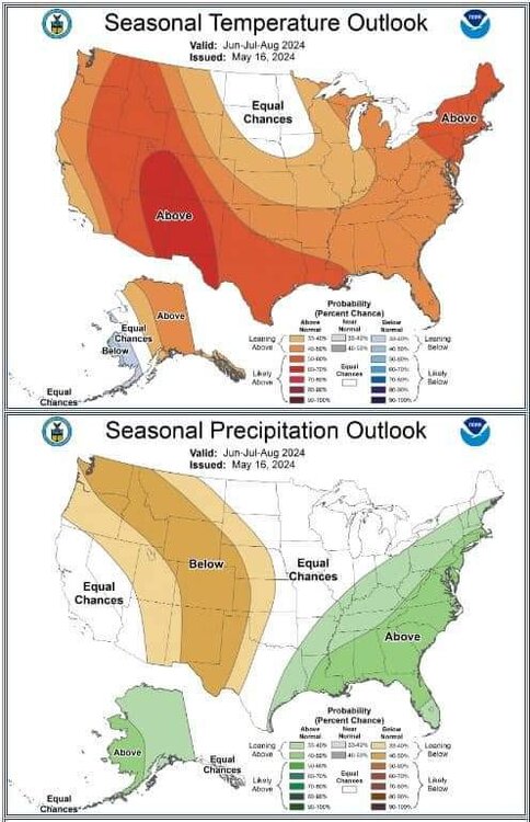
MU: Following showers and periods of light rain tonight and tomorrow, an upper-level ridge, or northward bulge in the #JetStream, will return to the eastern U.S. next week. The sinking motion under the ridge will promote lots of sunshine and above-average temps from Monday-Thursday! -

2024-2025 La Nina
40/70 Benchmark replied to George001's topic in Weather Forecasting and Discussion
If anything, this is likely to be a case in which the ONI may peak at say 1.4, but the MEI/RONI are like 1.7. Same page. -
That’s pretty much a persistence forecast based on the summer patterns since the 15-16 super El Niño. The rainfall is based on the record warm Atlantic and extremely active tropical cyclone potential plus persistence since 15-16.


- 863 replies
-
- 1
-

-
- spring
- cool temps
- (and 3 more)
-
I know it sounds not good for the Police Officer I believe they say he is hurt. There is a Felony charge as well.
-

May 2024 Discussion - Welcome to Severe Season!!!!
Typhoon Tip replied to weatherwiz's topic in New England
All seriousness ... ( and tedium ), it's a nice out there today. 70 here. I'm noticing that the CU trajectory and the llw wind is actually more NE were I am here in N . Middlesex in east central Mass. That's technically not a marine flow here. With sat presentation showing only micro fluffies getting in the way of the sun, we're probably going to be just fine this mid day. Maybe the s-breeze mechanics overwhelm late in the day. I also noticed the 12z NAM is a little better for Sunday. It's probably going to be cooler coast, warmer deep interior type thing. Could see that being 63 here and 53 at Logan. ...75 in ALB. With sun around. That's a better scenario than prior run. -
Warm overnight lows and above average highs like Florida
-

Texas 2024 Discussion/Observations
Powerball replied to Stx_Thunder's topic in Central/Western States
-
Central Pa. Spring 2024
Itstrainingtime replied to mahantango#1's topic in Upstate New York/Pennsylvania
I'm watching. I don't have a clue how he can even concentrate after what happened. I'd be a train wreck. -
Sure it does. In the summer you can get rounds of storms drop 3-5” in a day or two while a heat wave or two on other days pushes temps overall well above average.
-
He is playing and birdie the first hole.
-
Tropical moisture?
-
Starting to clear out here.
-
hot and wet makes no sense...
-
Too bad we haven’t been able to get a great +IOD pattern like this during recent winters with the Western IO forcing dominant over the Maritime Continent.


-
A flood watch down here ? Wow - That's about the same as a winter storm watch for the I95 corridor... These things dont happen much anymore...
-
lol The base state is proving once again to be a force. Next week does look intriguing, though.
-
May 2024 Discussion - Welcome to Severe Season!!!!
Typhoon Tip replied to weatherwiz's topic in New England
Fixed
-
63 cloudy and some drizzle. Some clearing/sun in eastern sections as the onshore pushes clouds and moisture inland. more of the same tomorrow before clearing our later on Sunday. Warmup Tue (5/21) - Wed (5/22). Overall, warmer progression but tendency for rain / onshore into next weekend.
-

May 2024 Discussion - Welcome to Severe Season!!!!
WxWatcher007 replied to weatherwiz's topic in New England
Hot, humid, and east coast tropics threats. -
Thank God
- 863 replies
-
- 1
-

-
- spring
- cool temps
- (and 3 more)
-
Where ? Not on the coast up here.
-
Strongly agree. And the earlier “This Niña isn’t going to couple well and strengthen because of the +IOD” argument by some on twitter is very rapidly falling apart like the IOD is
-

May 2024 Discussion - Welcome to Severe Season!!!!
SouthCoastMA replied to weatherwiz's topic in New England
There will probably be a violent snap to heat and humidity once the junky onshore pattern subsides. The pukey flow has been tough to get rid of, like a stage 5 clinger -
Hot Hot Hot