All Activity
- Past hour
-
 Gorgeous out. 59F.
 -
Next week looks pretty chilly. My highest forecast is 52. Tuesday will be a struggle to hit 40. More 20's to come.
-
True, that’s another difference…+QBO back in 2010
-

Central PA Fall Discussions and Obs
Itstrainingtime replied to ChescoWx's topic in Upstate New York/Pennsylvania
Very heavy thunderstorm in progress. -
(002).thumb.png.6e3d9d46bca5fe41aab7a74871dd8af8.png)
Central PA Fall Discussions and Obs
ChescoWx replied to ChescoWx's topic in Upstate New York/Pennsylvania
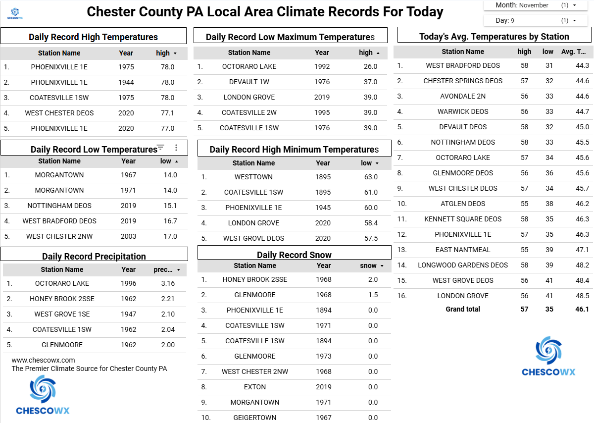
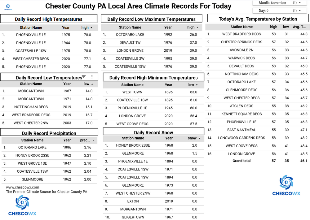
Some sun this morning, but showers are possible almost anytime today and tonight. We could see between 0.15" to 0.25" of rain by late tonight. Today will be our last mild day with temperatures a couple of degrees above normal with low 60's in the valleys. A strong cold front moves through late tonight and we fall back to near 40 degrees by morning. Our high temperature tomorrow will occur at midnight tonight with temperatures only rising a couple of degrees tomorrow morning before falling to freezing by tomorrow evening. Tuesday will likely see the higher spots remaining in the 30's for high temperatures. We will moderate a bit by Wednesday but temperatures for the rest of the week will remain well below normal for mid-November with highs struggling to escape the 40's through the week.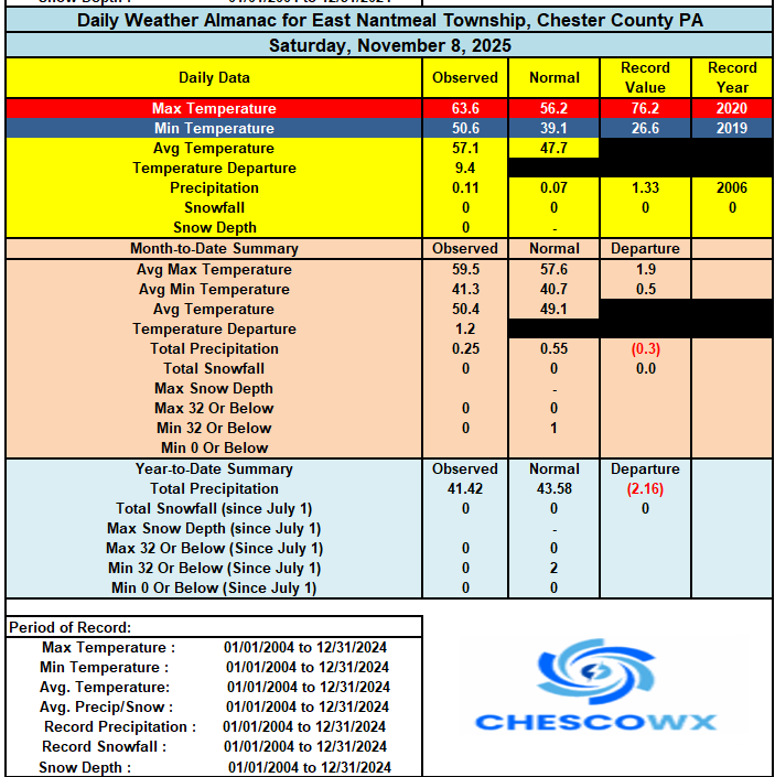
-
E PA/NJ/DE Autumn 2025 Obs/Discussion
ChescoWx replied to PhiEaglesfan712's topic in Philadelphia Region
Some sun this morning, but showers are possible almost anytime today and tonight. We could see between 0.15" to 0.25" of rain by late tonight. Today will be our last mild day with temperatures a couple of degrees above normal with low 60's in the valleys. A strong cold front moves through late tonight and we fall back to near 40 degrees by morning. Our high temperature tomorrow will occur at midnight tonight with temperatures only rising a couple of degrees tomorrow morning before falling to freezing by tomorrow evening. Tuesday will likely see the higher spots remaining in the 30's for high temperatures. We will moderate a bit by Wednesday but temperatures for the rest of the week will remain well below normal for mid-November with highs struggling to escape the 40's through the week.
-

11/8-11/10 First Snow and Lake Effect Event
ChiTownSnow replied to Geoboy645's topic in Lakes/Ohio Valley
My thoughts exactly.. I'm just happy I could enjoy first flakes this morning and not just some overnight mix -

November 2025 general discussions and probable topic derailings ...
dendrite replied to Typhoon Tip's topic in New England
Looks like the snow line is from Gene to N Conway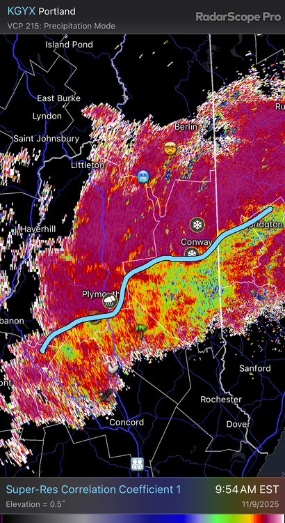
-
It’s possible I’m mistaken? But I thought that happened last December? Maybe it was the year before?
-

11/8-11/10 First Snow and Lake Effect Event
donsutherland1 replied to Geoboy645's topic in Lakes/Ohio Valley
Yes, I agree. I don't see O'Hare getting the top-end accumulations. I still think 4" or above is reachable, but not guaranteed given this setup. -

11/8-11/10 First Snow and Lake Effect Event
Chicago Storm replied to Geoboy645's topic in Lakes/Ohio Valley
If it works out perfectly, you’re getting Buffalo-ed. As you well know, odds say it won’t. But, if it does… -

2025-2026 New England Snow Recordkeeping Thread
MarkO replied to bristolri_wx's topic in New England
Welp, it's currently snowing at my cabin, so time to start my season totals. -

November 2025 general discussions and probable topic derailings ...
wxeyeNH replied to Typhoon Tip's topic in New England
33.9F Moderate catpaws -
This is your winter.
-

11/8-11/10 First Snow and Lake Effect Event
homedis replied to Geoboy645's topic in Lakes/Ohio Valley
Overall short term guidance seems pretty consistent with the snow band. 12z suite came a touch west with the main band compared to 06z, but only time will tell. Nevertheless, trying to not get my hopes up too much as we know how these setups can easily pull out of NE IL and into NE IN pretty fast -

11/8-11/10 First Snow and Lake Effect Event
magoos0728 replied to Geoboy645's topic in Lakes/Ohio Valley
If any of this verifies in lakeshore areas around the city, the mess it'll cause will be off the charts. I lived in Cobb County GA during a early December snowstorm and it took down power lines across the area. The night of the snowfall was lit up by transformers blowing across the area -

November 2025 general discussions and probable topic derailings ...
dryslot replied to Typhoon Tip's topic in New England
Speaking in front of an empty chalice. -

11/8-11/10 First Snow and Lake Effect Event
A-L-E-K replied to Geoboy645's topic in Lakes/Ohio Valley
Taking the under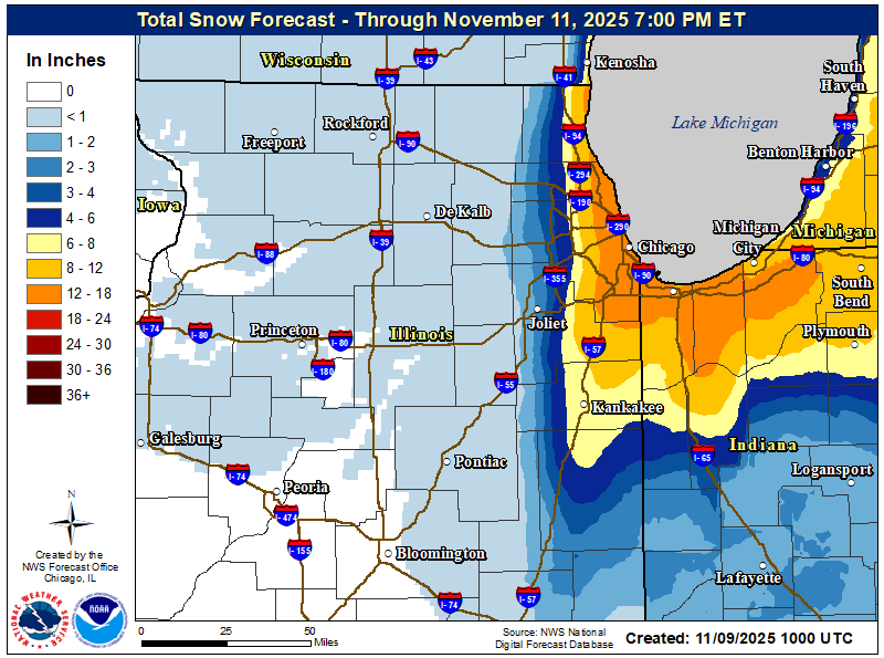
-
11/8-11/10 First Snow and Lake Effect Event
Chicago Storm replied to Geoboy645's topic in Lakes/Ohio Valley
The problem re: Chicago snowfall records… The core of activity will likely be east of ORD. So, in the end, it may be tough to see any sort of record falls, unless best activity is surprisingly further west. Orientation may even keep MDW out of the absolute best as well, but we’ll see. Better shot there than ORD. Of course, nothing there would be official, but it would be documented at least. -

Mid to long range discussion- 2025
WinstonSalemArlington replied to wncsnow's topic in Southeastern States
There’s a chance -

11/8-11/10 First Snow and Lake Effect Event
Brian D replied to Geoboy645's topic in Lakes/Ohio Valley
I've been having snow shwrs in my area since yesterday. Dusting in town this morning. -

November 2025 general discussions and probable topic derailings ...
SJonesWX replied to Typhoon Tip's topic in New England
aside from yesterday, what day(s) have been “warm”? -

Fall 2025 WX Discussion Thread
Save the itchy algae! replied to Carvers Gap's topic in Tennessee Valley
Sounds like the local office is going to expand advisories in the pm update. We’ll see! Getting my leaves situated by the road hoping the cold front blows them down the street later.. . -
The current and recent KCHS NWS forecasts for KSAV have been for 30 on 11/11 in a windy freeze. If that were to verify, it would be the earliest 30 or colder since way back in 1976! However, latest and recent model consensus is suggesting that 30 is on the low end (Icon). ICON actually warmed some from 27s on Sat runs. Latest ICON/GFS/CMC/Euro/UKMET (through 6Z/0Z 11/9 runs) have 30/32/33/33/34. If this were a radiational cooling night, I’d likely favor the low end per slight warm bias of consensus. But with it being windy, I’m currently thinking near the model avg of 32. However, if the model consensus were to cool, I’d adjust colder. Even just getting to 32 would mean the earliest freeze since 2010!
-
Beautiful day again