All Activity
- Past hour
-
We also had this kind of situation here on November 7, 2012 in the snowstorm after Sandy. 8-10 inches of snow and hazardous driving conditions with tree branches down everywhere. 14 inches south of us in Freehold, NJ. A very different winter from 2002-03 of course.
-
You mean 2002. That wraparound was amazing. I had about 8 inches but like 2 miles east were reports of almost 10 inches. I was driving a rear wheel drive stick shift car with performance tires not equipped for winter conditions. That evening was a crash course in winter driving lol. Car actually got stuck in the parking spot that I somehow managed to get it into.
-
Lets roast Tuesday and Wednesday. Bring it on!
-
A few normal days with warm temperatures then back down to low 80’s & chances of rain. Sat outside under our lights on the porch last night. No skitters or bugs. Quite cool & loved it. Have also been sitting on our screen porch a lot. These temps are fantastic & everything is so green! Winning summer so far!
-
If they're tent caterpillars you'll see webs in the v of trees.
-
Upton’s AFD for today, NEAR TERM /UNTIL 6 PM THIS EVENING/... Winds have been increased with this update to account for gusts that have occurred higher than expected. Moderate to heavy rainfall is beginning to taper with the low moving into the Lower Hudson Valley and SW CT. A Flood Watch remains in effect for the Lower Hudson Valley through 11 am. This area has racked up 1-3" inches of rain with many of the higher amounts in Orange county. Some wrap-around precipitation will move through mid to late morning through much of the area as the low exits north and east. As we get into late morning and early afternoon, the low will continue to exit northeast of the area. This brings in drier air & cuts off most of the more intense precip. Spotty to isolated showers may still occur into the early afternoon. Another chance for brief downpours with showers and thunderstorms may occur with a frontal passage behind the departing low late this afternoon into early tonight. Instability is marginal, so only a few rumbles of thunder are expected. Flood impacts will be minimal given the quicker progression of these showers with the front and given coverage will be less compared to this morning. Ahead of and with the front, a LLJ with move through west to east, which could lead to a spike in winds, leading to gusty conditions.
-
The 500mb low closed off in the right spot. The front end was ruined because the storm hugged the coast, but the closed off low kicked the low east and wrapped moisture around to the west to create the backlash heavy snow band.
-
Same. Let's go!
-
That would be my guess too. You're not going to really notice tent caterpillars.
-
A section of Upton’s AFD, NEAR TERM /UNTIL 6 PM THIS EVENING/... Winds have been increased with this update to account for gusts that have occurred higher than expected. Moderate to heavy rainfall is beginning to taper with the low moving into the Lower Hudson Valley and SW CT. A Flood Watch remains in effect for the Lower Hudson Valley through 11 am. This area has racked up 1-3" inches of rain with many of the higher amounts in Orange county. Some wrap-around precipitation will move through mid to late morning through much of the area as the low exits north and east. As we get into late morning and early afternoon, the low will continue to exit northeast of the area. This brings in drier air & cuts off most of the more intense precip. Spotty to isolated showers may still occur into the early afternoon. Another chance for brief downpours with showers and thunderstorms may occur with a frontal passage behind the departing low late this afternoon into early tonight. Instability is marginal, so only a few rumbles of thunder are expected. Flood impacts will be minimal given the quicker progression of these showers with the front and given coverage will be less compared to this morning. Ahead of and with the front, a LLJ with move through west to east, which could lead to a spike in winds, leading to gusty conditions.
-
02-03 was my second most favorite winter after 1995-96. It had everything-- the Christmas Miracle, the February 20"+ KU snowstorm and the April snowstorm too.
-
Happy belated!
-

E PA/NJ/DE Spring 2025 Obs/Discussion
MGorse replied to PhiEaglesfan712's topic in Philadelphia Region
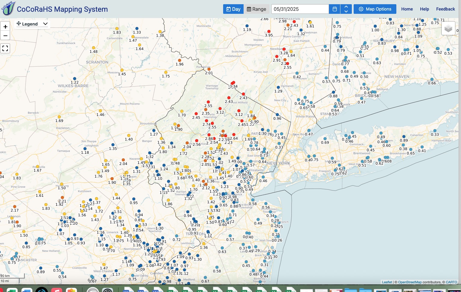
1.04 inches of rain. -
amazing to have it happen at the last possible moment and on Christmas lol. That was an out and out amazing winter, haven't had a beginning to end winter like that since (I rank it higher than 09-10, 10-11, 13-14 and 14-15 because of the 20 + inch big KU snowstorm in February a big snowstorm in April and the Christmas miracle snowstorm of course.)
-
More of the same old. The extensive high pressure across the North Pacific is indicative of a continued -PDO regime. It’s definitely taking longer to switch modes than I thought it would. My guess is that we have at least another year to go before there is a full scale decadal change….
-
and the "Storm will make it's own cold air" actually worked out too. It was in the low 50's here that morning with heavy rain-by midafternoon it was 30 with heavy snow
-
Yeah that’s a big part of it. From my memory that storm was bombing out as it passed overhead. Likely very strong dynamics were able overcome drying.
-
That 2.28 in Chester makes sense based on my wheelbarrow. Last of it lifting out now.
-
 DCA: +2.4 NYC: +2.4 BOS: +2.0 ORD: +1.4 ATL: +1.2 IAH: +1.0 DEN: +0.7 PHX: +2.5 SEA: +0.2
 -
I really liked the calls for under 1 inch for the city and points east. 0.75 was the highest near me, about what I expected.
-
Most guidance and WPC were all over the location of potentially max rainfall for the last 2 days and it worked out well.
-

Central PA Spring 2025
Itstrainingtime replied to canderson's topic in Upstate New York/Pennsylvania
Current totals: 0.17" since midnight 1.11" so far for the event 10.37" so far in May. -
The one time back end snows actually worked out.
-
we bottomed out at 29.16 now slowly rising as the winds increase.
-
Odd weather down here....feels like we went through the 'eye' of the storm, winds went calm, sun came out. Now we are getting into the 'SW quadrant' with heavy rains and pretty gusty too