All Activity
- Past hour
-
Yikes.
-

12/14: Sunday funday? Will the south win again?
NorthArlington101 replied to TSSN+'s topic in Mid Atlantic
works for me!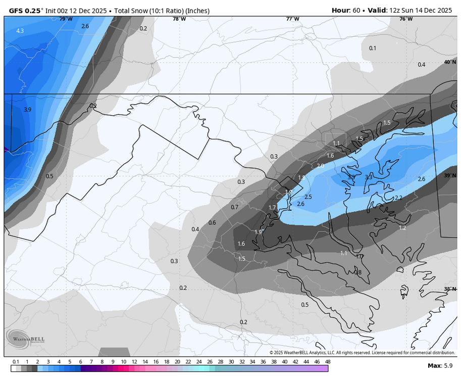
-

Saturday night/Sunday 12/13-12/14 Jawn
LVblizzard replied to Ralph Wiggum's topic in Philadelphia Region
I went with 2-4” for the Lehigh Valley on my page. Not buying the GFS (which stubbornly held serve at 0z), it’s always lost in the short to medium range and doesn’t catch on until the day before. -
The GFS will not budge
-

Minor snow possible sunday 12/14/25
MJO812 replied to WeatherGeek2025's topic in New York City Metro
Gfs.thumb.png.ba46dfdb212df796437ca6862a8c7c31.png)
-

December 11th - 12th clipper potential
John1122 replied to Holston_River_Rambler's topic in Tennessee Valley
Special Weather Statement National Weather Service Morristown TN 1020 PM EST Thu Dec 11 2025 TNZ012>018-035>047-070-121100- Scott TN-Campbell-Claiborne-Hancock-Hawkins-Sullivan-Johnson- Morgan-Anderson-Union-Grainger-Hamblen-Northwest Cocke- Cocke Smoky Mountains-Northwest Greene-Southeast Greene- Washington TN-Unicoi-Northwest Carter-Southeast Carter-Jefferson- Including the cities of Big South Fork National, Oneida, Smokey Junction, Elgin, Huntsville, Norma, Slick Rock, Fincastle, La Follette, Elk Valley, Jellico, White Oak, Caryville, Royal Blue, Lone Mountain, Sandlick, Springdale, Arthur, Harrogate-Shawanee, Clairfield, Howard Quarter, Evanston, Sneedville, Treadway, Kyles Ford, Mooresburg, Kingsport, Bristol TN, South Holston Dam, Doeville, Mountain City, Neva, Shady Valley, Trade, Laurel Bloomery, Pine Orchard, High Point, Petros, Oak Ridge, Clinton, Maynardville, Norris Lake, Paulette, Rose Hill, Sharps Chapel, Luttrell, Bean Station, Alpha, Morristown, Russellville, Bybee, Newport, Hartford, Greeneville, Cedar Creek, Johnson City, Erwin, Unicoi, Limestone Cove, Elizabethton, Hampton, Jefferson City, Strawberry Plains, Chestnut Hill, Dandridge, and White Pine 1020 PM EST Thu Dec 11 2025 ...Bands of Snow Through Early Friday Morning... Bands of snow will move across the northern Plateau and northeast Tennessee through early Friday morning. The heaviest band may quickly produce 1/2 to 1 inch of snow mainly areas near the Kentucky and Virginia state line. Travel impacts will be possible through early morning especially elevated surface such as bridges and overpasses. Drive with caution and slow down. $$ -

12/12: The little Friday clipper that could? Or won't.
wxdude64 replied to dailylurker's topic in Mid Atlantic
Unless it 'rounds the bend' soon Boone and Greensboro might have a better shot of some flakes. -

December 2025 Short/Medium Range Forecast Thread
Golf757075 replied to John1122's topic in Tennessee Valley
The WCS does a daily PDO number compared to CPC, which only does a monthly reading. Its been extremely negative, but has risen pretty good -
Looks like it extends to the south shore of Nassau. Long Beach/5 Towns probably snowing in that band.
-

December 2025 regional war/obs/disco thread
TauntonBlizzard2013 replied to Torch Tiger's topic in New England
Gfs looks a tad worse through 42. I wouldn’t expect much help from that model -
The junction of I-287 and I-80 looks like it got into that band pretty good. I bet it dropped a quick 1/2" plus in that area.
-
Right before a lull. New round about to come through.
-
12/12: The little Friday clipper that could? Or won't.
wxdude64 replied to dailylurker's topic in Mid Atlantic
Yep, I was a 2" or less thinker from the start of this. BUT, sometimes a surprise happens, and we've been hot lately...... -

December 2025 regional war/obs/disco thread
WinterWolf replied to Torch Tiger's topic in New England
So, you think cuz the icon shows nothing, then that’s the final forecast? Hard to figure you out? -
December 11th - 12th clipper potential
Kentucky replied to Holston_River_Rambler's topic in Tennessee Valley
.png.c964da26dba7a623a2d008bfa9c1077e.png)
-
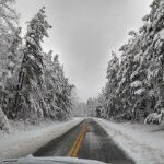
It even reached here. About an inch. Not as much as you but it all adds up.
-
Rgem still is gross but way better than 18z. Gets a couple inches to the M/D line. If it was a little colder it would be great. Pretty wet.
-
You live in the Mid Atlantic your Jonesing for snow. Head to the Alleghenies and Snowshoe! This place has been getting shellacked for DAYS! https://www.snowshoemtn.com/media-room/skidder-slope-live-cam
-

December 2025 regional war/obs/disco thread
powderfreak replied to Torch Tiger's topic in New England
It's not accumulating very fast, but there's some steady gusty small flake (arctic sand) falling. It covers things up quickly but doesn't stack very well. Cold shallow moisture continues to stream into the region on NW flow. Nocturnal inversion is trying to squeeze out all remaining moisture from an arctic airmass.
-

December 11th - 12th clipper potential
Jed33 replied to Holston_River_Rambler's topic in Tennessee Valley
Fine flakes but pretty steady to occasionally moderate here now. Light dusting on car and grass -
Love the OZ ICON. How's the 0z lookin?
-

December 11th - 12th clipper potential
Reb replied to Holston_River_Rambler's topic in Tennessee Valley
Got a couple quarters mixing in now in Seymour -
Let a man dream
-
You are now obligated to change your name to Jenkins Jinxes when this actually happens.
-
Special weather statement for tonight for nyc


.png.8a9428a0777e4947b3746be1d6f22ffd.png)


