All Activity
- Past hour
-
-13 here and still dropping. Dew is down to -25.
-

Possible Record Breaking Cold + Snow Sunday 1/25 - Tuesday 1/27
jm1220 replied to TriPol's topic in New York City Metro
Good thing I don't have to commute there. -

Possible Record Breaking Cold + Snow Sunday 1/25 - Tuesday 1/27
lee59 replied to TriPol's topic in New York City Metro
NYC has a chance to break their record of longest stretch of below 32 temperatures. -

Possible Record Breaking Cold + Snow Sunday 1/25 - Tuesday 1/27
NJwx85 replied to TriPol's topic in New York City Metro
The piles of black and yellow snow in Brooklyn are going to look great next week. -
As crazy this storm has been to track, who knows.
-
I think there is almost a diving line in the Lehigh Valley between who sees 8+ and who doesn’t when all the trending and everything is said and done. My expectations for Allentown/Bethlehem etc is these areas top out around 7/8in and then get dosed with slop
-

Possible Record Breaking Cold + Snow Sunday 1/25 - Tuesday 1/27
SnoSki14 replied to TriPol's topic in New York City Metro
We might set some modern snow pack longevity records with no warm ups in sight after the storm. That glacier will last a very long time -

Central PA Winter 25/26 Discussion and Obs
AccuChris replied to MAG5035's topic in Upstate New York/Pennsylvania
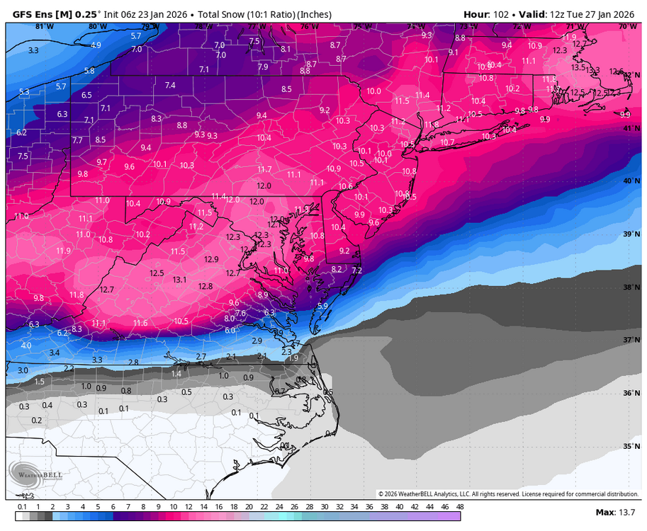
Excellent write up by NWS State College in their AFD: “All in all, the probability of snowfall amounts exceeding 12 inches has increased to 60-80 percent across much of central PA. The probability of more than 18 inches ranges from 15 to 40 percent. Amounts near 24 inches can`t be ruled out (10 percent chance) especially if the comma head sits over central PA Sunday night. Always prepare for the worst case scenario and continue to check the forecast as it evolves. Now is the time to prepare. Think snow blowers, re-arranging travel plans to avoid travel during the storm, what to do in case of a power outage, etc. Remember it will be very cold before, during and after the storm. Never run a generator indoors due to carbon monoxide. Now if you really enjoy meteorology and want to know *why* we are predicting the most significant accumulations in the past 5+ years, feel free to read on through the remainder of this KEY MESSAGE 2 discussion. We`ve had our fair share of cold snaps this winter season, and tomorrow (Friday) will be no exception after the next Arctic front pushes through. A large factor driving all this cold weather has been the Polar Vortex displaced from the North Pole, with a tendency for the vortex to find itself over Hudson Bay and northern Quebec. With displacement that far south, we`ve gotten plenty of cold air, but it`s also nudged the storm track south of our area for many of the recent events. If you`ve ever heard people say "it`s too cold to snow", it`s not that it`s physically too cold to snow, it usually just means that the storm track has shifted far enough to the south that we end up under dry high pressure while our temps are cold. One key difference this time is the influence of a Pacific storm, located off the coast of southern California this evening, and a strengthening subtropical jet to its south. Over the next 24 hours these features will cross the Baja Peninsula of Mexico and then into Texas. Southwesterly flow out ahead of this southern stream feature will pump warmer air into the Gulf Coast and Southeastern US Saturday night into Sunday. At the same time, a northern stream shortwave trough coming down from western Canada into the Great Plains will bring a reinforcing shot of cold air to the back side of the northern longwave trough. The increasing temperature gradients will result in an overall increase in wind speed aloft at jet stream altitude, and an amplification of the northern stream trough and ridge. By Sunday, the right entrance region of the northern jet and the left exit region of the southern jet will align to produce enhanced upward motion through the troposphere. Remaining uncertainty in the forecast largely depends on the degree of phasing of these two jets, the angle at which they align, and how much amplification there is of the ridge out ahead of the deepening trough. The very cold air in place ahead of this system also plays other crucial roles to increase impacts. At 00Z Sunday, model consensus depicts a 1040+ mb high over New York State, which only slowly moves northeastward across New England over the next 24 hours. The deep, cold blocking high to the northeast of a winter storm is a textbook feature that supplies a stream of cold air down the Alleghenies and provides a cold dome for warmer, less dense air parcels streaming in from the southwest to ascend over. That upward motion is key to production of hydrometeors - in this case snow. And then there is the key role that cold temperatures have on ice crystal habits. The so called "dendritic growth zone" exists where temperatures are between roughly 0F and 10F. Given low temperatures Saturday night in the single digits, some spots might start off with a DGZ that extends from the ground up 10,000 to 15,000 feet which is pretty remarkable for a large synoptic storm in this region. As long as the column saturates quickly enough, any snow that falls late Saturday night and into early Sunday morning could be very high ratio, fluffy, rapidly accumulating snow that consists of many pristine dendrites (SLRs 15-20:1, could be even higher if the column saturates faster but there is dry air at low levels to overcome at onset). So after a few hours of virga, accumulations have the potential to begin with a vengeance in the predawn hours Sunday, especially from I-80 south.” . -

Possible Record Breaking Cold + Snow Sunday 1/25 - Tuesday 1/27
BoulderWX replied to TriPol's topic in New York City Metro
NAM should give pause. I hate the model but I think it’s very good at detecting warm noses. -
It’s been sooooo stubborn the past 2-3 days.
-
Is there a rogue member or two stretching the mean?
-

“Cory’s in LA! Let’s MECS!” Jan. 24-26 Disco
bristolri_wx replied to TheSnowman's topic in New England
LOL I reported that because one day I thought my ability to click on a map correctly/accurately was impaired! Took me a few minutes to figure it out. -

Possible Record Breaking Cold + Snow Sunday 1/25 - Tuesday 1/27
psv88 replied to TriPol's topic in New York City Metro
Models look great! Nice to see icon and RGEM snowier -
and next two panels, snow-Sandy ... won't happen.
-
I don’t know I think it will cap out at about route 44 line
-
What makes this hard to believe is because it's showing snow down to what looks like Orlando FL. That would be crazy.

-
One thing that will help with Ice is the current warm ground temps. I have seen heavy rain falling into temps in the low 20s and none of the ice accumulating on the roads. I remember being shocked at how it just refused to build up where the tires of cars made contact with the road. Of course, bridges and overpasses had patches, Because they had not been frozen before the onset of the freezing rain the falling precipitation and action of the tires friction kept the roads free of ice. This may help us in the East Tennessee Valley. NOT SAYING IT WILL NOT BE DANGEROUS BUT IT MAY HELP.
-
LR EPS doesn't even get above freezing until after hr 300. Ridiculous
-
Possible Record Breaking Cold + Snow Sunday 1/25 - Tuesday 1/27
jm1220 replied to TriPol's topic in New York City Metro
Oh yeah. Sleet has more bang for its buck-doesn't pile up like snow obviously but will thicken up the snowpack and be a huge pain to move. After 3/14/17 the snow/ice piles were crazy. I remember the Feb 2007 storm in central PA with 10-11" of thick snow/sleet that hardened up into cement. A week from now even though we shave a few snow inches off for sleet I doubt people will be complaining if they like snowpack staying around like me. -

January 25-26 Winter Storm Potential
MickeyTim6533 replied to Ralph Wiggum's topic in Philadelphia Region
geez, gfs at hour 228....wow -
I’ve decided to just pretend the GEFS knows WTF it’s doing
-
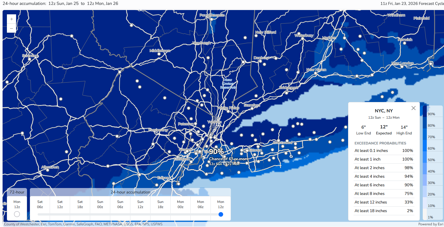
 Latest NWS probabilistic estimate of 6" or more snow for New York City: 90% Islip was at 81% and Newark was at 88%.
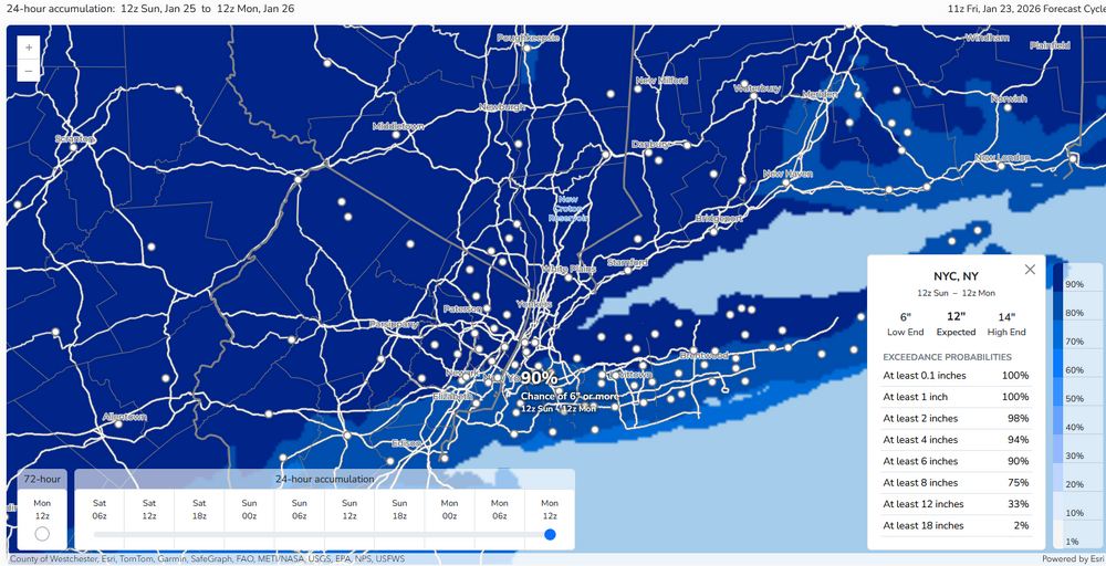
-

January 24-26: Miracle or Mirage JV/Banter Thread!
H2O replied to SnowenOutThere's topic in Mid Atlantic
Oh and lol to come back this morning to people fucking fighting over snow maps -
Btw….to anyone using the Beta site on Pivotal be careful when clicking soundings. When I’m in landscape mode the lat/long is correct, but when I flip the view to portrait it’s shifting my longitude off by a solid 1°.
-
January 24-26: Miracle or Mirage JV/Banter Thread!
H2O replied to SnowenOutThere's topic in Mid Atlantic
If it sleet bombs like the models show then I say fucking bring it. Gimme a ton of it. I’ll take sleet over ZR and plain rain all day, every day